![]()
![]()
![]()
![]()
![[thunderstorm cloud]](thunderstorm_noaa.jpg)
|
| Mature thunderstorm with typical anvil shaped cloud. |
Thunderstorms are violent weather systems. Fortunately, most thunderstorms are spatially small and temporally short-lived. Only a small fraction of all thunderstorms are classified as severe thunderstorms.
Thunderstorms form when moist, unstable air is lifted vertically into the atmosphere. The processes that initiate the vertical lifting were previously discussed. These are unequal heating of the Earth's surface (surface heating and free convection), orographic (mountain) lifting, dynamical lifting, which occurs near areas of lower level convergence and/or upper level divergence, and lifting because of the presence of a frontal zone -- each of these can initiate thunderstorm development. You may want to review the Conditions which force air to rise as each of these can initiate thunderstorm development.
Immediately after lifting begins, a rising parcel of warm moist air begins to expand and cool. At a certain elevation the parcel will reach saturation with respect to water vapor resulting in condensation and the formation of a cumulus cloud. During condensation, large quantities of latent heat are released. Much of the energy used in thunderstorm development comes from the release of latent heat. It is the heat released by condensation within a cloud that permits the rising air to stay warmer than its surroundings, and thus to be buoyant through great depths.
With the vertical extension of air parcels, the cumulus cloud grows into a cumulonimbus cloud. Cumulonimbus clouds can reach heights of 20 kilometers above the Earth's surface. Severe weather associated with thunderstorms includes hail, strong winds, lightning, intense rain, flash flooding, and tornadoes. A picture of a large thunderstorm is shown on the left. Shallow clouds in the foreground have not reached the unstable layer. The tall cumulonimbus cloud traces the path taken by unstable parcels of air. The anvil at the top of the cloud indicates where rising parcels become stable and begin to spread out horizontally.
Thunderstorm development requires an unstable atmosphere. The more unstable the atmosphere, the more violent the potential thunderstorm. There are three basic ways to make the atmosphere more unstable. You should understand how each of these changes to the atmosphere tend to make it more unstable.
Three changes that can make the atmosphere more unstable:
It is estimated that more than 40,000 thunderstorms occur each day throughout the world. Annually, this adds up to nearly 15 million thunderstorms per year across the surface of the Earth. The figure below shows the spatial density of annual lightning flashes around the world as measured with satellite instrumentation.
![[Worldwide lightning flashes from satellites]](global_lightning_new.png)
|
| Average number of lightning flashes per year (per square km). Color key is at the bottom of the image. Data are based on satellite-borne optical lightning detectors LIS and OTD. (Image courtesy of NASA.) |
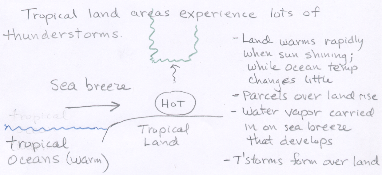
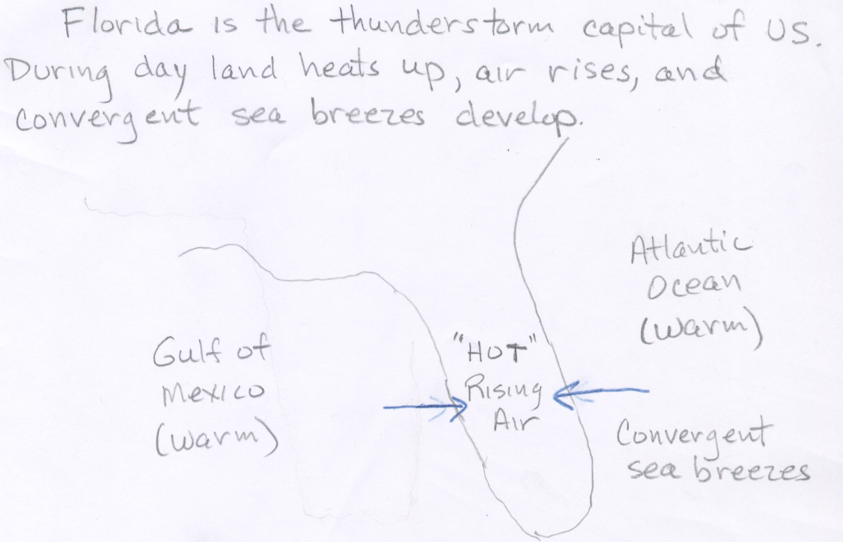
Thunderstorms form from the equator to as far north as northern Alaska and Siberia. Thunderstorms are most common over land areas in and near the tropics, with the global hot spot over central Africa. Tropical regions receive intense sunshine all year round, and the heating contrast between the land and ocean surface causes warm unstable air over land to rise up and form thunderstorms (see this hand drawn diagram.) Thunderstorm formation over tropical oceans far from land areas is less frequent because ocean surfaces do not warm as rapidly as land surfaces. In general, thunderstorms are more common over land areas and over oceans adjacent to land than over the oceans far from land. Outside the tropics, thunderstorm formation is more seasonal occurring most often in those months where heating from the sun is most intense (late spring through early fall). While tropical areas do produce the most thunderstorms per year, the most common place for severe thunderstorms is in the middle latitude regions of the Earth. In these regions, warm moist tropical air can mix with cold polar air, which sets the stage for severe thunderstorms.
![[thunderstorm frequency - US]](US_Tstormdays_new.PNG)
|
| The average number of days each year on which thunderstorms are observed thoughout the United States. Taken from Koehler, T. L., (2020). Cloud-to-Ground Lightning Flash Density and Thunderstorm Day Distributions over the Contiguous United States Derived from NLDN Measurements: 1993 – 2018. Mon. Wea. Rev., 148, 313 – 332, https://doi.org/10.1175/MWR-D-19-0211.1. |
The figure above describes the annual average number of thunderstorm days across the United States. This figure includes all thunderstorms. Most thunderstorms are not severe thunderstorms. You should be familar with the thunderstorm characteristics of three distinct regions, labeled (1) - (3) below.
![]()
![]()
![]()
![]()