![]()
![]()
![]()
![]()
We do not have time to emphasize everything on this page. You will be expected to know the lifecycle of a single cell thunderstorm. You are expected to understand what thunderstorm updrafts and downdrafts are and basically how they form. The formation of updrafts requires the release of latent heat during condensation (cloud formation) in order for air parcels to become warmer than the surrounding air (unstable) and accelerate upward, since a warm parcel of air is lighter and less dense than the surrounding, cooler air. The formation of downdrafts requires evaporation of rain, which cools the air in air parcels since liquid rain must absorb energy from the air in order to evaporate. If this evaporatively cooled air becomes colder (and thus heavier and more dense) than the surrounding air, it accelerates down toward the ground as a downdraft and spreads outward along the ground as a gustfront. You should also know what hail is and how it forms and what microbursts are and how they form. You should know what a gust fronts are and that they can lead to dust storms in desert regions. Hopefully, you will be able to follow other items discussed on this page, though there will not be specific exam or homework questions about the other material. I hope you enjoy some of the pictures and links to pictures of thunderstorms provided.
A thunderstorm is simply a storm that produces lightning and thunder. Some thunderstorms never produce precipitation. Thunderstorms are sometimes classified by type as shown in this document, Types of thunderstorms. This classification system is somewhat arbitrary, though, and not every thunderstorm will fit exactly into a single category. Most thunderstorms are not severe and would be classified as the single cell type. Fortunately, the most severe thunderstorms, the mesoscale convective complexes and supercells, are relatively rare. These most severe storms are quite complex and not fully understood. There would be no way to cover the details of those storms in a class like this. We will instead focus on the lifecycle of a typical single cell thunderstorm, then go on to discuss a couple of the mechanisms that allow some thunderstorms to become more organized and severe. The material should provide a basic understanding of thunderstorm development, however, you need to realize that not every thunderstorm will fit the idealized descriptions presented.
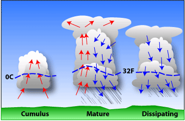 |
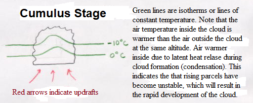
| Simplified model depicting the life cycle of an ordinary thunderstorm that is nearly stationary. (Arrows show vertical air currents. Dashed line represents freezing level, 0°C isotherm.) |
As the surface air is lifted to its condensation level, condensation begins and latent heat is released, enhancing the buoyancy of the rising air. Much of the energy for thunderstorm development comes from this release of latent heat as this is what allows parcels to remain warmer than the surrounding air over great vertical depths. Once the rising parcel is able to pass the transition level from stable to unstable, rising air within the cloud becomes warmer than the surrounding air and it accelerates upward, which helps to bring in more air from below. These rising air currents are called updrafts. Thus, a phase change of water (condensation during cloud formation) that explains how updrafts form. A growing cumulus cloud is observed in this stage. See picture for the cumulus stage. Note that in the picture, the 0°C isotherm (line of constant temperature) bows upward inside the cloud to indicate that the updraft air is warmer than the air surrounding the cloud at the same altitude. Early stages of thunderstorm development are dominated by updrafts. Hand-drawn picture for cumulus stage
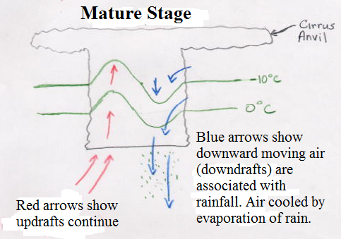
Eventually, the processes that transform a cloud of small droplets into precipitation-sized drops take over and the cloud particles (liquid droplets and ice) get so large that the updraft can no longer hold them up and they begin to fall. As precipitation falls below the cloud base, it encounters a region of the atmosphere that is unsaturated. Thus, some of the liquid water and ice evaporates on the way down to the ground. Falling air parcels, containing precipitation, can become colder than the surrounding environmental air due to this evaporative cooling. In a sense this is opposite to the unstable updraft. Falling air parcels that become colder (and more dense) than the surrounding environmental air will accelerate downward, causing more air from above to follow. This evaporatively cooled air, which accelerates downward, is called a downdraft. Notice in the picture of the mature stage that the 32°F isotherm bows down near the downdraft to indicate that the downdraft air is colder than the air surrounding it. Again it is a phase change of water that explains how downdrafts form. Most thunderstorms produce downdrafts, and if conditions are right, they can be quite strong and destructive. When downdraft air hits the ground it spreads outward and moves along the ground, as a gust front. You may have experienced a gust front as a blast of cold air hitting you just before thunderstorm rains begin. Gust fronts are like mini cold fronts as they are the dividing line between cold downdraft air spreading out and the warm, humid air surface air present when the thunderstorm started to form. At this time when precipitation (possibly heavy) is falling from part of the cloud with updrafts and downdrafts both occurring marks the mature stage of a thunderstorm, when it is most powerful. Hand-drawn picture for mature stage
![[microburst]](microburst.jpg)
|
| Rain shaft and spreading gust front in the desert. |
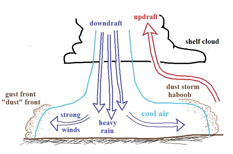
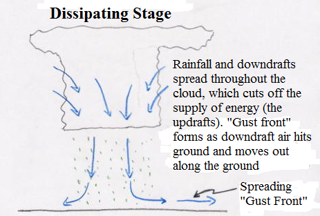
In its weakening phase, thunderstorm downdrafts dominate throughout much of the cloud. The downdrafts hit the surface and spread cold air outward, eventually shutting off the updrafts. This kills the storm because it cuts off its energy supply of warm, humid air. Lighter rain may continue to fall for a short time as updrafts are no longer holding up the larger cloud particles. Sometimes the spreading cold air at the surface (gust fronts) can initiate new thunderstorms tens or even hundreds of miles away. Under the right conditions gust fronts can result in dangerous dust storms with little rain, especially in desert regions. Hand-drawn picture for dissipating stage and showing gust front. As mentioned above the spreading gust front is like a mini cold front as it is the leading edge of cold downdraft air pushing into warm surface air that was needed to get thunderstorms started.
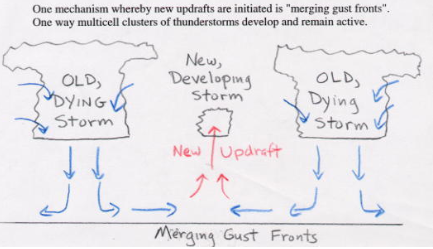
A single cell thunderstorm dies when its energy supply of warm humid air in the updrafts is cut off. In order for thunderstorms to live longer than a single cell thunderstorm and possibly become severe, there must be some sort of organization to the storm (or clusters of storms) that allow updrafts to continue. One way for that to happen is a mechanism known as merging gust fronts (see conceptual picture of merging gust fronts). Where gust fronts meet, there is an area of covergence at the surface, which forces air to rise. If the atmosphere is unstable at this convergence, a new thunderstorm may be initiated. This mechanism can produce multi-cell clusters of thunderstorms.
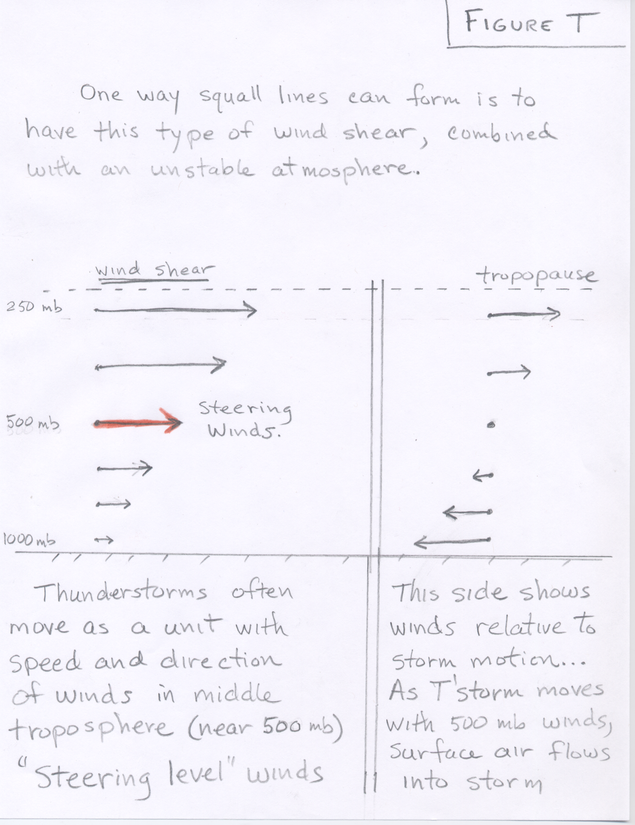
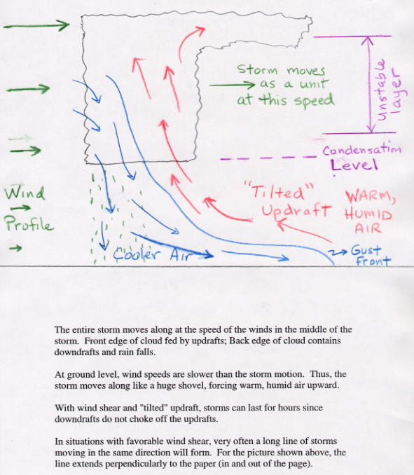
Most often severe thunderstorms require vertical wind shear to form. Vertical wind shear is a situation where the winds change in speed and/or direction at different altitudes. This is something that can be visualized using a skew-T diagram. Favorable types of vertical shear, or the change of winds with height, interact dynamically with thunderstorms to enhance and maintain vertical draft strengths. Therefore, vertical wind shear is an important item for meteorologists to consider when forecasting the possibility of severe thunderstorms. Thunderstorm squall lines can form in regions where the vertical wind shear is such that the wind speed increases with increasing altitude. This type of wind shear is shown in this two panel diagram of speed shear. To understand how this works, you need to consider that individual thunderstorms are typically moved or steered along by the winds in the middle troposphere, close to where the air pressure is 500 mb. Thus the right panel shows the wind profile relative to the storm motion or the winds at 500 mb. Since the thunderstorm will move in the same direction as the surface winds, only faster, a steady supply of warm, humid surface air flows into the storm. Please see this instuctive drawing of a squall line. You are not expected to be able to explain how squall lines form, though you should know that they often produce gust front lines that can produce strong and damaging winds along the ground. Repeating again, the spreading gust front is like a mini cold front as it is the leading edge of cold downdraft air pushing into warm surface air that was needed to get thunderstorms started.
Squall lines and mesoscale convective complexes can develop over huge areas if conditions are favorable (see Satellite images of a squall line and an MCS). I am unsure of the difference between an MCC (mesoscale convective complex) and an MCS (mesoscale convective system).
Organized squall lines often produce rather strong surface winds in association with the gust front. In desert regions, the squall lines can act to create dust storms. Below is a picture of a dust storm along the leading edge of a gust front taken in the Phoenix area on August 2, 2018. Dust storms like this are often called haboobs.
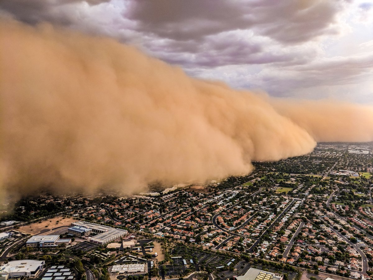 |
| Dust storm in Phoenix, AZ on August 2, 2018 |
The picture below shows some of the features at the base of a thunderstorm. The cold downdraft air spilling out of a thunderstorm hits the ground and begins to move outward from underneath the thunderstorm. The leading edge of this outward moving air is called a gust front. Desert residents think of it as a dust front because the gust front winds often stir up a lot of dust.
 |
If you search, you will find lots of dust storm videos posted on the web. Here is a link to a short article, What are haboobs? Amazing pics and videos, which contains pictures and videos.
The US National Weather Service defines a severe thunderstorm as a storm that is producing 3/4 inch diameter or larger hail and/or surface wind gusts of 50 knots (58 mph) or greater. Hail is a type of precipitation consisting of balls or irregular clumps of ice. Hail formation requires a thunderstorm with strong upward motion of air over a large vertical extent, which must include a large region of below freezing air temperature. All hailstones begin as a seed or nuclues around which the hailstone will grow. The seed is typically a piece of ice, but it can be solid debris carried up by a thunderstorm, such as insects. In order to understand hail formation, you must realize that in the region of a cumulonimbus (thunderstorm) cloud, where the air temperature is between 0°C and -40°C, it is common for many of the cloud droplets to be in the form of supercooled water, i.e., liquid water droplets that have a temperature below the normal freezing point of water. If a supercooled droplet of water collides with a piece of frozen material (ice crystal or growing hailstone), the supercooled water will rapidly freeze around the outside of the ice. As a growing hailstone moves up and down through the supercooled region of the cloud, it grows by accretion of new ice with each collision (see hail formation diagram above). You should be able to understand and explain how hail forms as described and shown in the figure above. Large hail can be quite destructive. On average hail is responsible for over 1 billion dollars in property damage each year in just the United States alone. To make large hail very strong updrafts are required to hold up the growing hailstone against the force of gravity. The largest hailstone recovered in the U.S. fell in Vivian, SD on June 23, 2010 with a diameter of 8 inches and a circumference of 18.62 inches. It weighed 1 lb 15 oz (Image). Link to Google Images for large hailstones where many claim to be the largest. Be careful as several images are faked.
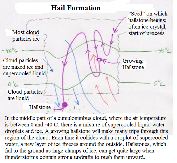
Hail formation diagram. |
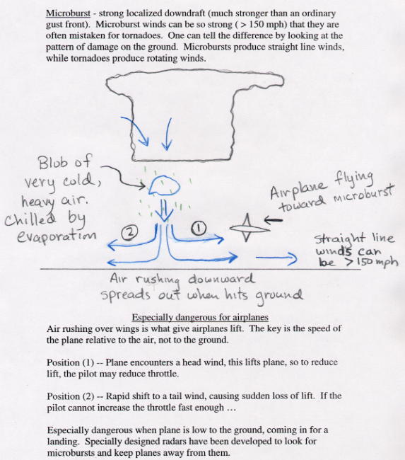
Microburst diagram. |
A microburst is a small very intense downdraft that descends to the ground, then spreads out along the ground as a strong gust front moving away from the microburst core (see diagram above). Microbursts can produce wind speeds of greater than 150 miles per hour and thus are capable of causing significant damage. Microburst winds can be stronger than the winds observed in some hurricanes and tornadoes. Because microbursts and tornadoes are both associated with severe thunderstorms, it is common for people to mistake microburst wind damage for tornado wind damage. The pattern of the wind damage can be used to distinguish the two since tornadoes produce rotational winds while microburst winds move out linearly (straight line wind damage) from the microburst core. The total size of the microburst is typically less than a few miles in diameter and tend to last on the order of a few to ten minutes. Microbursts form in the same way as ordinary downdrafts. However, while downdrafts occur with most thunderstorms, damaging microbursts are relatively rare. When rain falls below cloud base or is mixed with dry air, it begins to evaporate and this evaporation process cools the air. When the evaporatively cooled air becomes colder and more dense than the surrounding air, it accelerates downward. As this cold air approaches the ground, it spreads out in all directions and this divergence of the wind is the signature of the microburst. Micorbursts are particularly dangerous for air travel as described in the picture above.
Some excellent weather videos and stills of Arizona thunderstorms, including microbursts and duststorms, have been taken by Brian Snider over the years. Brian captured an amazing video of a thunderstorm with "wet" microbursts over Tucson on August 8, 2015. Here is a link to Original Footage taken by Brian Snider. I recommend this very well done annotation using Brian's video. As mentioned in the video, a wet microburst contains rain. In dry microbursts all of the rain evaporates before the downdraft reaches the ground. Remember these videos and pictures have copyrights. A still picture of a thunderstorm with a spreading gust front, perhaps a weak microburst, is shown above on this page.
All thunderstorms require instability (potential) and lift. The lift is the mechanism that releases the instability. Lift is produced by such things as fronts and low pressure troughs or by air rising upslope or possibly surface heating and free convection.
We say that the atmosphere is unstable when air rising in a cloud is warmer than its environment, like a hot-air balloon. It is the heat released by condensation within a cloud that permits the rising air to stay warmer than its surroundings, and thus to be buoyant through great depths. This heat release leads to the formation of thunderstorm updrafts.
In the same way, air that is cooler than its environment tends to sink as long as it can stay cooler than its surroundings. This can happen when falling precipitation evaporates and cools air, which forms thunderstorm downdrafts.
The upward moving air in a thunderstorm is known as the updraft, while downward moving air is the downdraft. The atmosphere can be unstable for updrafts but stable for downdrafts, stable for updrafts but unstable for downdrafts, stable for both, or unstable for both. The degree of atmospheric instability is one of the two major factors in determining the strengths of thunderstorm updrafts and downdrafts.
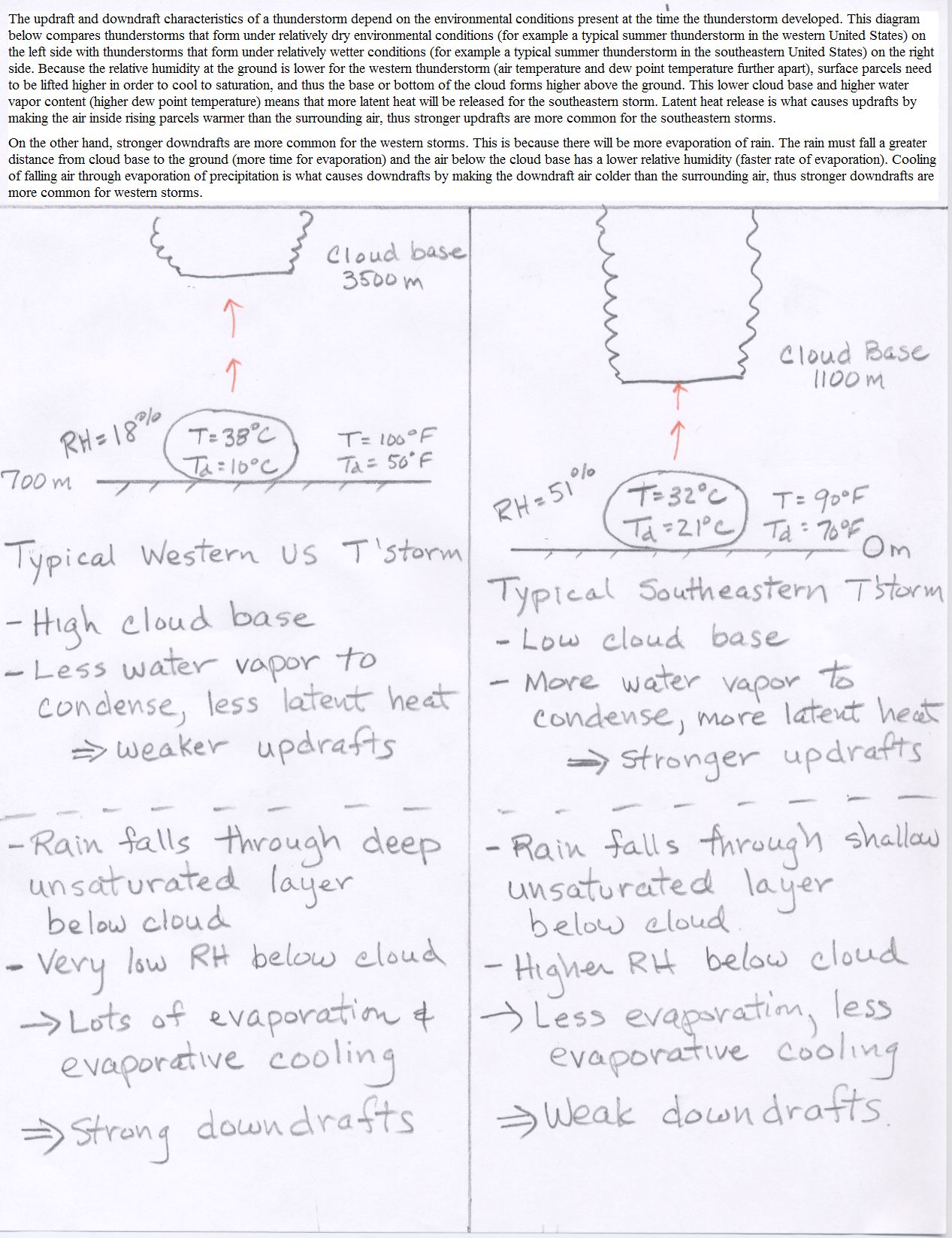
When the low-level air is unstable but relatively dry, a storm may develop with a weak updraft but a strong downdraft with the latter the result of strong negative buoyancy and cooling through evaporation of precipitation into the dry air. This high-based storm resembles high terrain, western U.S. storms which occasionally produce dry microbursts. Significant hail and heavy rain are unlikely (see Figure comparing a typical Western US thunderstorm with a typical Southeastern US thunderstorm). You are expected to understand the comparison and the reason why storms with weak updrafts and strong downdrafts are common with thunderstorms that develop under relatively dry surface conditions.
A storm which contains a strong updraft and weak downdraft will not produce wind damage, but can foster heavy rains and/or damaging hail. Single and multicell storms comprise this category. They include storms that dump heavy rain, but little or no hail because of warm conditions aloft, and multicell storms that are capable of producing hail because of lower environmental freezing levels. Strong updraft, weak downdraft storms often form in very moist atmospheres where there is little, if any, dry air and evaporational cooling to drive downdrafts. Storms with strong updrafts and weak downdrafts are common in the southeastern part of the United States. Again, please refer to the Figure comparing a typical Western US thunderstorm with a typical Southeastern US thunderstorm).
Relatively weak updrafts and downdrafts are found with non-severe showers and thunderstorms. The last possible combination is a storm with strong updrafts and downdrafts. These storms frequently produce destructive downbursts, hail, heavy rain, and tornadoes. As one would expect, the most severe storms, including supercells, have strong vertical updrafts and downdrafts and occur in the most unstable atmospheres.
 |
| Supercell thunderstorm. The powerful main updraft can be seen by the presence of an overshooting top above the anvil (the dome cloud). Photo by Howard Bluestein. |
Extremely severe thunderstorms most often form in areas with strong vertical wind shear. Vertical shear, or the change of winds with height, interacts dynamically with thunderstorms to either enhance or diminish vertical draft strengths. Vertical wind shear is a critical factor in the determination of thunderstorm type and potential storm severity.
Thunderstorms which occur in weak vertical wind shear usually have an erect appearance. These storms don't last as long as strong storms in a sheared environment since the rainy downdraft quickly undercuts and chokes off the updraft. If any severe weather occurs with these weak-shear storms, it will be brief, occurring just prior to dissipation.
We refer to storms in sheared environments as organized convection. Organized storms are longer-lived, usually have preferred areas of new updraft development, and often allow for some predictability of periodic severe weather events.
When the atmosphere is extremely unstable with just the right type of wind shear, supercell thunderstorms can form. In most supercell thunderstorms, the strong updraft will rotate counterclockwise as the air rises. This is favored when the wind shear is such that the wind direction rotates counterclockwise with increasing altitude. Updraft speeds may reach over 100 mph. The storm organizes itself so that the rain, hail and subsequent downdrafts remain isolated from the rotating updraft, which allows the storm to remain violent for an extended period of time. Supercell thunderstorms often produce damaging microbursts, large hail, and torrential rains. Most monster tornadoes are born in supercell thunderstorms. Supercell storms can often be identified by the presence of a "dome cloud" extending above the main cloud mass (see picture on left). The dome is the result of strong updrafts "overshooting" the level where it would otherwise stop rising (i.e., where temperature of lifted parcels are no longer warmer than the surrounding air).
Instructive diagrams of supercell thunderstorms are shown below. The figure on the left side looks down on a supercell thunderstorm. The main updraft region is ahead of the gust front. Under the unstable atmospheric conditions and the vertical wind shear environment, the strong updrafts rotate as shown in the side view diagram on the right side. A dome cloud is depicted above the main updraft core. The area of heaviest rain and possible hail is located behind the updraft with respect to the overall motion of the storm. Tornadoes are common with supercell thunderstorms. As can be seen in the figure on the left side, some of the rain can start to get wrapped around the rotating updraft. The interaction of the rotating updraft and colder downdraft associated with the rain acts as a trigger for tornado development, though the exact physical mechanism is far from fully understood. Notice the green "hook" of rain and the marked location of a possible tornado in the figure on the left. The red triangle marks the most likely position for a tornado to occur in the figure on the right. Meterologists tracking supercell thunderstorms will issue a tornado warning when a "hook echo" is seen on weather radar. Don't worry, you are not expected to understand the details in the diagrams below.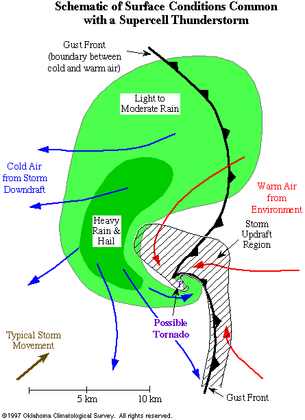 |
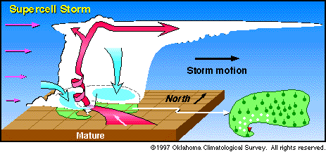 |
| This schematic looks down from above and displays typical surface conditions associated with a mature supercell thunderstorm. Note that the updraft and downdraft (rain area) regions are separated physically. In this manner, the supercell can exist in a quasi-steady-state for a few hours. | This diagram shows the structure of a mature "supercell" thunderstorm. (The vertical scale is exaggerated so that details of the cloud structure can be shown.) Pink arrows indicate the winds at various heights in the atmosphere. Red arrows are updrafts; blue arrows are downdrafts. Note that because wind speeds increase with height, rain falls away from the updraft, allowing the storm to be maintained for hours. Supercell thunderstorms are significantly more destructive than ordinary thunderstorms. |
Meteorologists responsible for forecasting where thunderstorms will form and how severe they may become pay close attention to two main factors: stability of the atmosphere, and wind shear. In order for thunderstorms to form, air parcels must rise up and become unstable. The larger the vertical extent of the unstable layer and the warmer rising parcels are relative to the temperature of the surrounding atmosphere, the stronger the storms can become. Vertical wind shear, changes in wind direction and windspeed with increasing altitude, can allow convection to become organized, longer-lived, and more violent (as opposed to the rapid life cycle of single-cell storms). In organized convection, the updraft region of a storm is able to remain isolated from the precipitation and subsequent downdrafts. In single-cell thunderstorms, rain and downdrafts falling into the updraft cut off the storm's fuel supply of warm, humid air.
The temperature, water vapor, and wind profiles of the atmosphere are measured twice daily (at 00Z and 12Z) from each weather station around the globe. This includes the Tucson airport, which is a weather station site. Measurements are taken by instruments attached to weather balloons that are released from the ground and rise upward. Between the routine observations, the temperature, water vapor, and winds are estimated by computer weather forecast models. Meteorologists must assess this available information when forecasting the possiblity of severe thunderstorms.
![]()
![]()
![]()
![]()