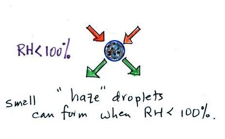
Thursday, Oct. 24, 2019

Amadou and Mariam "Senegal Fast Food" (4:20); Playing for Change "With My Own Two Hands" (4:06), "Tenia Tanto Que Darte" (4:31), "Minor Rag - Spanish Rag Medley" (4:11), "Clandestino" (3:47), "Satchita" (4:16)

We'll use page 84, page 86b, page 87, page 88, page 91 and page 92 from the ClassNotes packet in class today.  Page 89 and page 90 are part of a supplementary reading section that I will probably mention but not cover in class.

The Online Grades have been updated and now include estimates of your overall grade.  Here are some additional details about how the overall grades are computed (the details also provide some idea of  how PackBack participation can affect your overall average).

A new Optional Assignment was handed out in class today.  You had the option of handing it in at the end of class today or at the start of class next Tuesday (Oct. 29).


Here's a short review of humidity variables that also contains answers to the In-class Optional Assignment from Tuesday (Oct. 22)

I usually include the following example in the Lecture Notes but don't go through all the details in class.

Humidity example problem #3

Tair = ?
r = 10.5 g/kg
RH = 50% Td = ?


You're given the the mixing ratio = 10.5 g/kg and a relative humidity of 50%.    You need to figure out the air temperature and the dew point temperature.  Give it a try before you have a look at the step by step solution below:


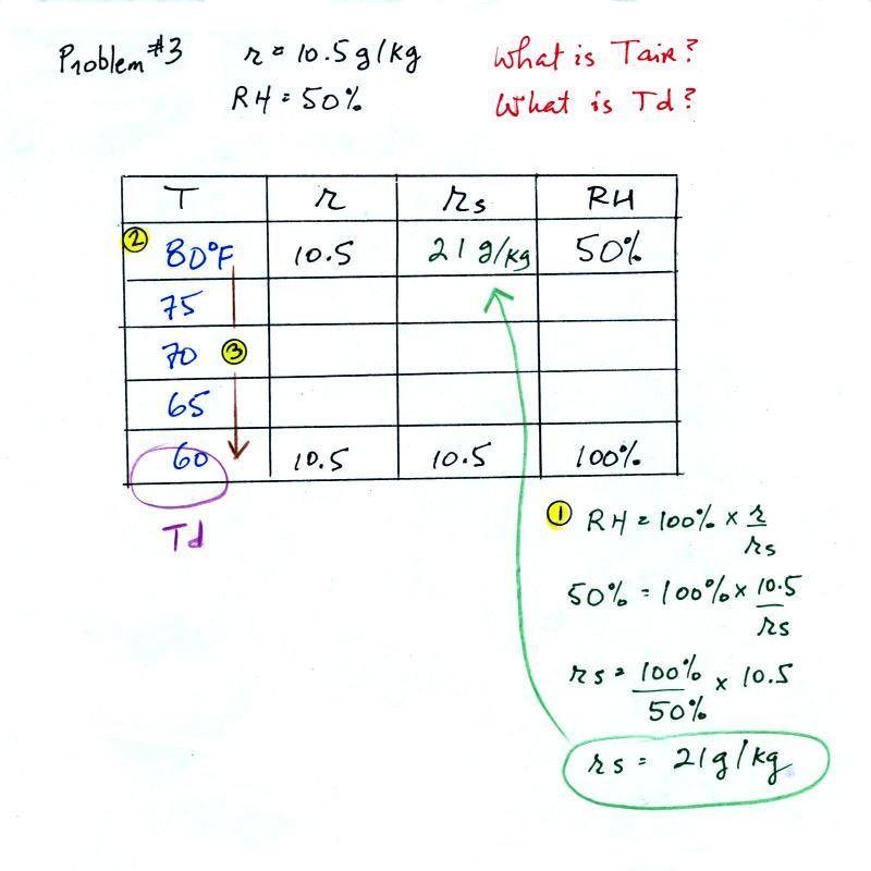
(1) The air contains 10.5 g/kg of water vapor.  This is 50% (half) of what the air could potentially hold.  So the air's capacity, the saturation mixing ratio must be 21 g/kg (you can either do this in your head or use the RH equation following the steps shown above). 

(2) Once you know the saturation mixing ratio you can look up the air temperature in a table (80 F air has a saturation mixing ratio of 21 g/kg)

(3) Then you imagine cooling the air until the RH becomes 100%.  This occurs at 60 F.  The dew point is 60 F


Humidity example problem #4

One of the "jobs" of the dew point, to give you an idea of the actual amount of water vapor in the air, is the same as the mixing ratio.  The next problem will demonstrate that if you know the dew point temperature you can quickly figure out the mixing ratio and vice versa.

Tair = 90 F
r = ?
RH = ?
Td = 50 F


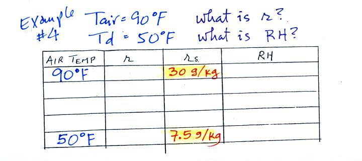
We enter the two temperatures given on a chart and look up the saturation mixing ratio for each.


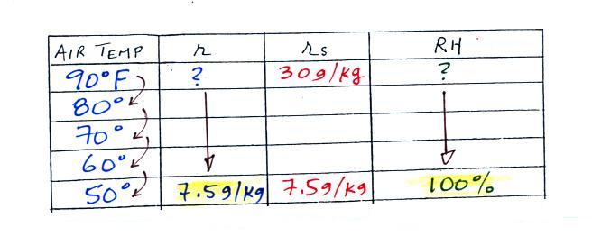
We ignore the fact that we don't know the mixing ratio.  We do know that if we cool the 90 F air to 50 F the RH will become 100%.  So on the 50 F row, we can set the mixing ratio equal to the value of the saturation mixing ratio at 50 F, 7.5 g/kg.  The two have to be equal in order for the RH to be 100%.


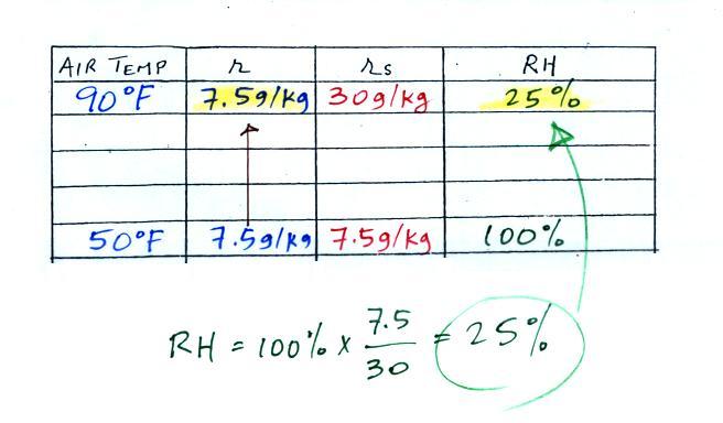
Remember back to the three earlier examples.  When we cooled air to the the dew point, the mixing ratio didn't change.  So the mixing ratio must have been 7.5 all along.   Once we know the mixing ratio in the 90 F air it is a simple matter to calculate the relative humidity, 25%.
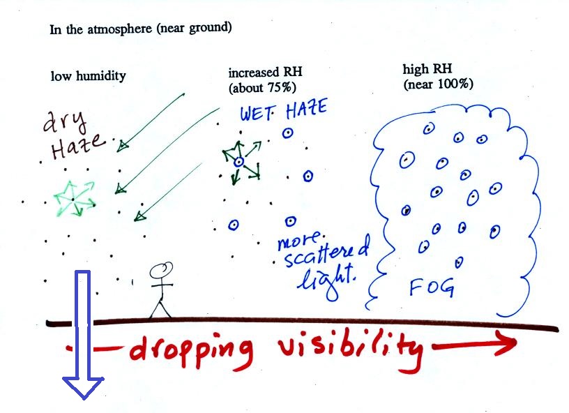
Drying moist air
The figure below has been squeezed into the left side of page 87 in the ClassNotes.  It explains how you can dry moist air.  This is something that Mother Nature does all the time.


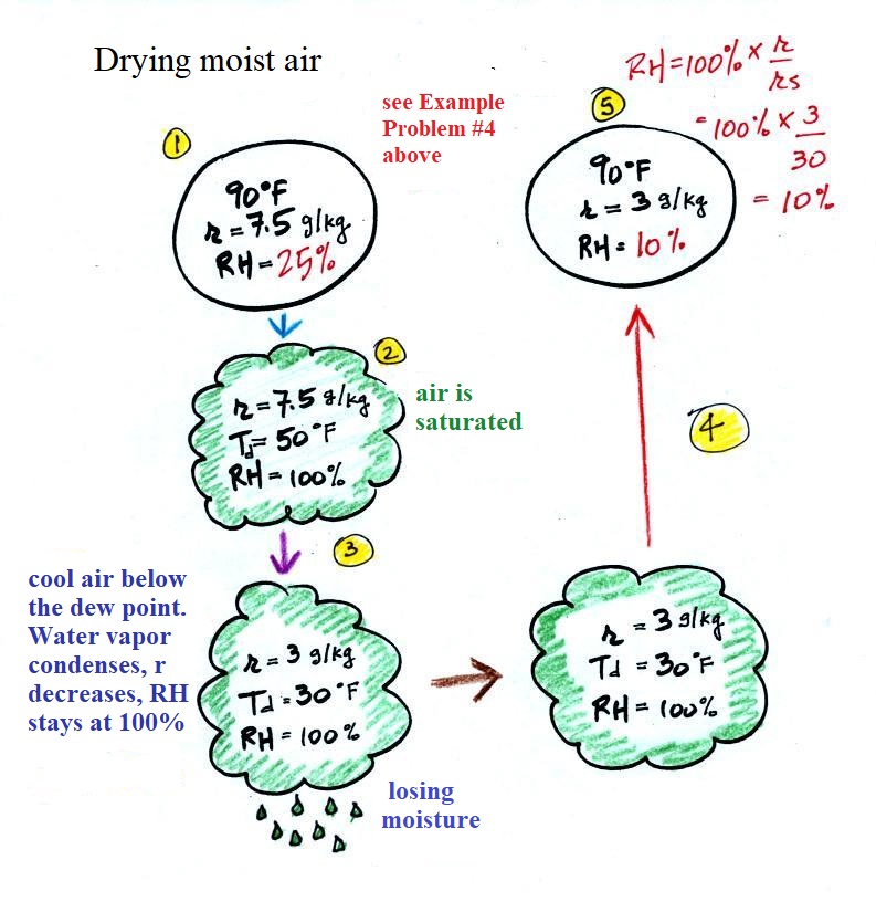
At Point 1 we start with some 90 F air with a relative humidity of 25%, fairly dry air.   These are the same numbers that we had in Example Problem #4.  We imagine cooling this air to the dew point temperature, 50 F.  While doing that the mixing ratio, r, would stay constant.  Relative humidity would increase and eventually reach 100%.  A cloud would form (Pt. 2 in the figure above). 

Then we continue to cool the air below the dew point, to 30 F.  Air that is cooled below the dew point finds itself with more water vapor than it can contain.  The excess moisture must condense (we will assume it falls out of the air as rain or snow).  Mixing ratio will decrease, the relative humidity will remain 100%.  When air reaches 30 F it contains 3 g/kg, 40% of the moisture that it originally did (7.5 g/kg). 

The air is being warmed back up to 90 F along Path 4. 
As it warms the mixing ratio remains constant.  Cooling moist air raises the RH.  Warming moist air, as is being done here, lowers the RH.  Once back at the starting temperature, Point 5, the air now has a RH of only 10%.

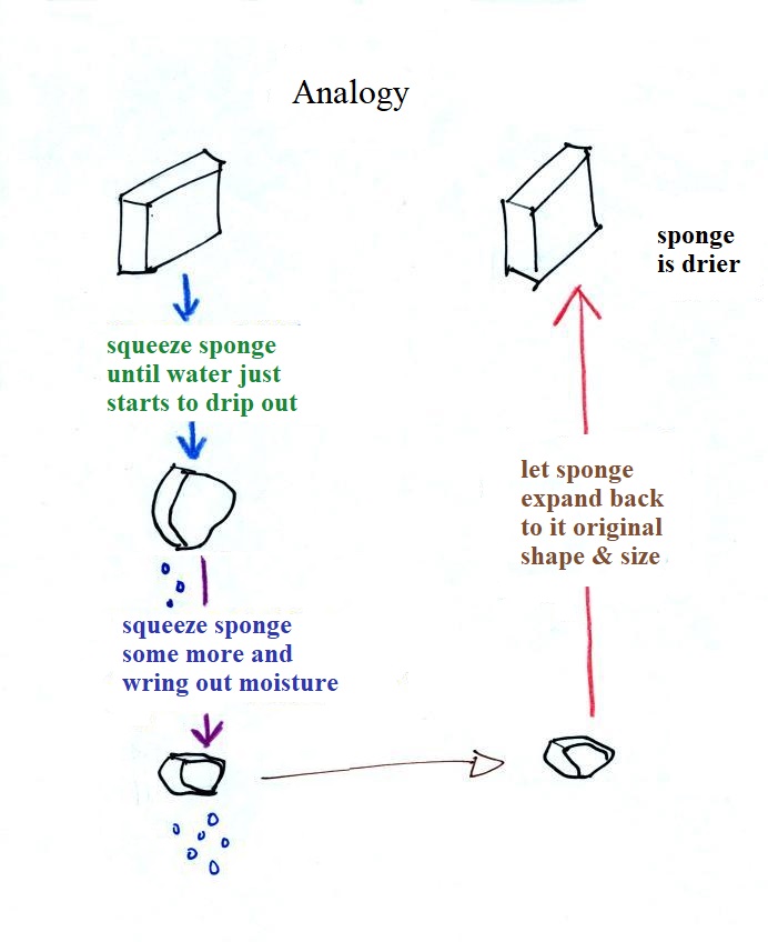
Drying moist air in this way is basically like wringing moisture from a wet sponge.


You start to squeeze the sponge and it gets smaller.  That's like cooling the air and reducing the saturation mixing ratio, the air's capacity for water vapor.  At first squeezing the sponge doesn't cause anything to happen (that's like cooling the air, the mixing ratio stays constant as long as the air doesn't lose any water vapor).  Eventually water will start to drop from the sponge (with air this is what happens when you reach the dew point and continue to cool the air below the dew point).  Then you let go of the sponge and let it expand back to its original shape and size (the air warms back to its original temperature).  The sponge (and the air) will be drier than when you started.


Dry air indoors in the winter
The air indoors in the winter is often quite dry (low values of the mixing ratio and relative humidity).


In the winter, cold air is brought inside your house or apartment and warmed.  Imagine foggy 30 F air (with a RH of 100% this is a best case scenario, the cold air outdoors usually has a relative humidity less than 100% and is drier). Bringing the air inside and warming it will cause the RH to drop from 100% to 20%..  This can cause chapped skin, can irritate nasal passages, and causes cat's fur to become charged with static electricity. 


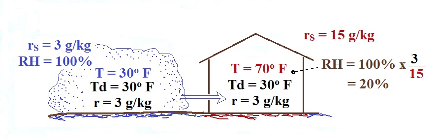
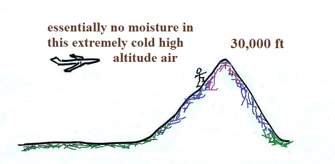
The air in an airplane comes from outside the plane.  The air outside the plane can be very cold (-60 F perhaps) and contains very little water vapor (even if the -60 F air is saturated it would contain essentially no water vapor).  When brought inside and warmed to a comfortable temperature, the RH of the air in the plane would be essentially 0%.  The RH doesn't get this low because the airplane adds moisture to the air to make to make the cabin environment tolerable.  Still the RH of the air inside the plane is pretty low and passengers often complain of dehydration on long airplane flightsThis may increase the risk of catching a cold (ref)

The rain-shadow effect

Next a much more important example of drying moist air (see page 88 in the ClassNotes).


We start with some moist but unsaturated air (the RH is about 50%) on the left (the air and dew point temperatures would need to be equal in order for the air to be saturated).  As it is moving toward the right the air runs into a mountain and starts to rise (this is an additional way of causing rising air motions).  Rising air expands and cools.   Unsaturated air cools 10 C for every kilometer of altitude gain (this is known as the dry adiabatic lapse rate but isn't something you need to remember).  So after rising 1 km the air will cool to 10 C which is the dew point.

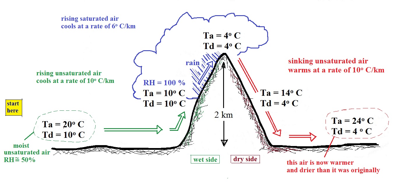
The air becomes saturated mid way up the mountain (the air temperature and the dew point are both 10 C).  Would you be able to tell if you were outdoors looking at the mountain?  Yes, you would see a cloud appear. 

Now that the RH = 100%, the saturated air cools at a slower rate than unsaturated air (condensation of water vapor releases latent heat energy inside the rising volume of air, this warming partly offsets the cooling caused by expansion).  We'll use a value of 6 C/km (an average value).  The air cools from 10 C to 4 C in next kilometer up to the top of the mountain.  Because the air is being cooled below its dew point, some of the water vapor will condense and fall to the ground as rain.  Moisture is being removed from the air and the value of the mixing ratio (and the dew point temperature) decreases.

The air starts back down the right side of the mountain.  Sinking air is compressed and warms.  As soon as the air starts to sink and warm, the relative humidity drops below 100% and the cloud disappears.  The sinking unsaturated air will warm at the 10 C/km rate. 

After passing up and over the mountain, the air ends up warmer (24 C vs 20 C) and drier (Td = 4 C vs Td = 10 C) than when it started out.  The downwind side of the mountain is referred to as a "rain shadow" because rain is less likely there than on the upwind side of the mountain.  Rain is less likely because the air is sinking and because the air on the downwind side is drier than it was on the upslope side.


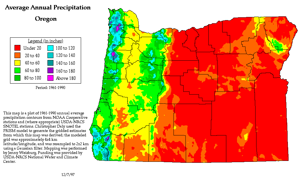
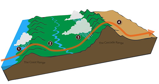
We can see the effects of a rain shadow illustrated well in the state of Oregon.  The figure above at left shows the topography (here's the source of that map).  Winds generally blow from west to east across the state. 

Coming off the Pacific Ocean the winds first encounter a coastal range of mountains.  On the precipitation map above at right (source) you see a lot of greens and blue on the western sides of the coastal range.  These colors indicate yearly rainfall totals that range from about 50 to more than 180 inches of rain per year.  Temperate rainforests are found in some of these coastal locations.  The line separating the green and yellow on the left side of the precipitation map is the summit, the ridgeline, of the coastal mountain range.

That's the Willamette River valley, I think, in between the coastal range and the Cascades.  This valley is somewhat drier than the coast because air moving off the Pacific has lost some of its moisture moving over the coastal range. 

What moisture does remain in the air is removed as the winds move up and over the taller Cascades. 
The boundary between yellow/green and the red is the ridgeline of the Cascade Mountains.  Yearly rainfall is generally less than 20 inches per year on the eastern side, the rain shadow side, of the Cascades.    That's not too much more than Tucson which averages about 12 inches of rain a year.


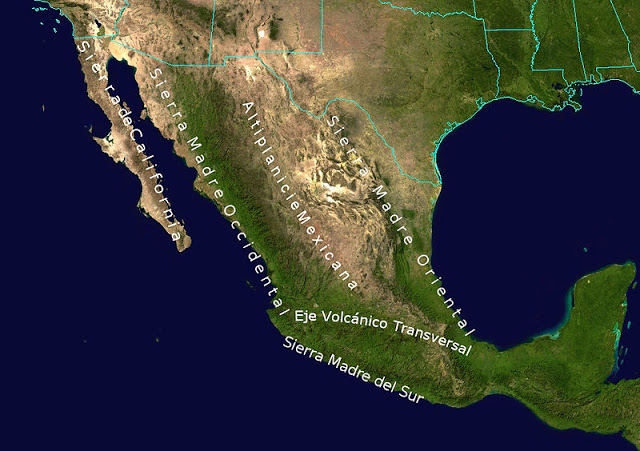
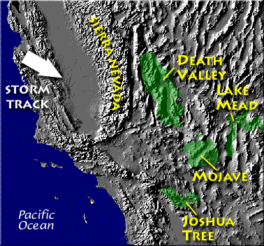
Death valley is found on the downwind side of the Sierra Nevada mountains (source of left image)The Chihuahuan desert and the Sonoran desert are found downwind of the Sierra Madre mountains in Mexico (source of the right image)Mexico might be a little harder to figure out because moist air can move into the interior of the country from the east and west at different times of the year.  It does appear that the eastern slopes of the two mountain ranges are the wettest so much of that precipitation must come from moist air moving in from the east (rising air motions on the eastern mountain slopes).

Most of the year,  the air that arrives in Arizona comes from the west, from the Pacific Ocean (this changes in the summer).  It usually isn't very moist by the time it reaches Arizona because it has traveled up and over the Sierra Nevada mountains in California and the Sierra Madre mountains further south in Mexico.  The air loses much of its moisture on the western slopes of those mountains.   Beginning in early July in southern Arizona we start to get air coming from the south or southeast.  This air can be much moister and leads to development of our summer thunderstorms.

Just as some of the world's driest regions are found on the downwind side (the rain shadow side) of mountain ranges, some of the wettest locations on earth are on the upwind sides of mountains.  There seems to be some debate whether Mt. Wai'ale'ale in Hawaii or Cherrapunji India gets the most rain per year.  Both get between 450 and 500 inches of rain per year.


Processes that cause air to rise
You might not have noticed that while covering the rain shadow effect we came across another process that causes rising air motions.  Rising air expands and cools.  Now you should know that if you cool moist air to its dew point, the relative humidity increases to 100% and clouds form.   Here's a pictorial summary of the four processes that cause rising air motions.


The newest process is called orographic or topographic lifting.

The drinking bird
Evaporative cooling and the dependence of saturation mixing ratio on temperature are both involved in the "drinking bird".


I'm very proud of the bird I found online.  It is about twice as big as what you normally find.  The bird is filled with a volatile liquid of some kind (ether?).  Initially the bird's head and tail are the same temperature.  The liquid inside the bird evaporates and saturates the air inside with vapor.

Next you get the bird's head wet.  Instead of water I cheat a little bit and use isopropyl alcohol (rubbing alcohol) because it evaporates more rapidly than water.  The evaporation of alcohol, just as with water, cools the bird's head.

As we saw last week, the saturation mixing ratio (saturation vapor concentration) of water depends on temperature.  Warm air can contain more water vapor than colder air.  The same applies to the ether vapor in this case.  The head is still saturated with vapor but there is less vapor in the cool head than there is in warm saturated air in the bird's tail.


The differences in amounts of vapor produce pressure differences.  The higher pressure at the bottom pushes liquid up the stem of the bird.  The bird becomes top heavy and starts to tip.

At some point the bottom end of the stem comes out of the pool of liquid at the base.  Liquid drains from the neck and the bird straightens up.


You can arrange the bird so that when it tips its beak dips into a small cup of water (or alcohol).  This keeps the head moist and cool and the dipping motion could go on indefinitely.
  Here's a video.

We took away the bird's supply of alcohol, the bird warmed up and stopped tipping.


Condensation nuclei and the formation of dew, frost, haze, fog, and clouds
Here's a visual summary of a part of what we'll be covering next.


A variety of things can happen when you cool air to the dew point and the relative humidity increases to 100%.  When moist air next to the ground becomes saturated (RH reaches 100%) water vapor condenses onto (or, in the case of frost, is deposited onto) the ground or objects on the ground.  This forms dew, frozen dew, and frost. 

When air above the ground cools to the dew point, it is much easier for water vapor to condense onto small particles in the air called condensation nuclei.  It would be much more difficult for the water vapor to condense and form small drops of pure water.  Both the condensation nuclei and the small water droplets that form on them are usually too small to be seen with the naked eye.  We can tell they are present because they scatter sunlight and make the sky hazy.  As humidity increases dry haze turns to wet haze and eventually to fog.  We'll try to make a cloud in a bottle and you'll be able to better appreciate the role that condensation nuclei play. 


Condensation nuclei and the role they play in cloud droplet formation

The air next to the ground cools during the night.  Sometimes it cools enough to reach the dew point.  Water vapor condenses onto objects on the ground and you find everything covered with dew (or frost) the next morning.  When this happens in the air up above the ground you might think that water vapor would simply condense and form little droplets.  This is not the case; we will find that small particles in the air called condensation play an essential role in cloud (and fog) formation.

it is much easier for water vapor
to condense onto small particles
called condensation nuclei
it would be much harder for water vapor
to just condense and form
small droplets of pure water


We won't go into all of the details that follow in class, though they aren't hard to figure out and understand.  You're free to just skip the details, but do remember that particles make it much easier for cloud droplets and clouds to form. 

When the air is saturated with water vapor (the relative humidity is 100%) the rates of evaporation and condensation above a flat surface of water will be equal.


There's no real reason for picking three arrows each of evaporation and condensation, the important point is that they are equal when the RH is 100%.

It's hard for water vapor to condense and form a small droplet of water because small droplets evaporate at a very high rate.  This is known as the curvature effect and is illustrated below.


The surface of the smallest droplet above at left has the most curvature and the highest rate of evaporation (6 arrows).  If a small droplet like this were to form, it wouldn't stay around very long.  With it's high rate of evaporation it would quickly evaporate away and disappear. 

The middle droplet is larger and would stick around a little longer because it does not evaporate as quickly.  But it too would eventually disappear.

The drop on the right is large enough that curvature no longer has an effect.  This drop has an evaporation rate (3 arrows) that is the same as would be found over a flat surface of water.  A droplet like this could survive, but the question is how could it get this big without going through the smaller sizes with their high rates of evaporation.   A droplet must somehow reach a critical size before it will be in equilibrium with its surroundings.

Particles in the air, cloud condensation nuclei (CCN), make it much easier for cloud droplets to form.  The figure below explains why.


By condensing onto a particle, the water droplet starts out large enough and with an evaporation rate low enough that it is in equilibrium with the moist surroundings (equal rates of condensation and evaporation). 

There are always lots of CCN (cloud condensation nuclei in the air) so this isn't an impediment to cloud formation. 

Now back to material that we will cover in class.
The following information is from the bottom of page 91 in the ClassNotes.


Note that condensation onto certain kinds of condensation nuclei and growth of cloud droplets can begin even when the relative humidity is below 100%.   These are called hygroscopic nuclei.
  Salt is an example; small particles of salt mostly come from evaporating drops of ocean water.

I might try to show a video tape, not a digital video but video recorded on a magnetic tape.  It will depend first of all on there being a VCR in the classroom.

Here are some more of the details that we won't cover in class. 

To understand how condensation onto particles can begin even before the RH has reached 100% we first need to learn about the solute effect


solution droplet
pure water droplet

Water vapor condensing onto the particle in the left figure dissolves the particle.  The resulting solution evaporates at a lower rate (2 arrows of evaporation).  A droplet of pure water of about the same size would evaporate at a higher rate (4 arrows in the figure at right).  Note the rates of condensation are equal in both figures above.  This is determined by the amount of moisture in the air surrounding each droplet.  We assume the same moist (the RH is 100%) air surrounds both droplets and the rates of condensation are equal. 

The next figure compares solution droplets that form when the RH is 100% (left figure) and when the RH is less than 100%.


the droplet is able to grow
the droplet is in equilibrium with its surroundings
even when the RH is less than 100%


The solution droplet will grow in the RH=100% environment at left.  You can tell the RH is less than 100% in the figure at right because there are now only 2 arrows of evaporation.  But because the solution droplet only has 2 arrows of evaporation it can form and be in equilibrium in this environment.


We should remember that much of what we see in the sky is caused by scattering of light.  There was a pretty good demonstration of light scattering during one of the music videos played earlier in the semester ("Strak ha pak" from a group called Startijenn).


The figure below is at the bottom of page 91 in the ClassNotes and illustrates how cloud condensation nuclei and increasing relative humidity can affect the appearance of the sky and the visibility.

The air in the left most figure is relatively dry.  Even though the condensation nuclei particles are too small to be seen with the human eye you can tell they are there because they scatter sunlight.  When you look at the sky you see the deep blue color caused by scattering of sunlight by air molecules mixed together with some white sunlight scattered by the condensation nuclei.  This changes the color of the sky from a deep blue to a bluish white color.  The more particles there are the whiter the sky becomes.  This is called "dry haze."  Visibility under these conditions might be anywhere from a few miles up to a few tens of miles.


(source of the image above)

A photograph of fairly severe air pollution in Paris that illustrates an extreme case of dry haze (this is more common and more severe in China and India).   In Paris cars with even numbered license plates weren't allowed into the city on certain days of the week, odd numbers were banned on other days.  Public transportation was free for a short time to try to reduce automobile use. 


The middle picture below shows what happens when you drive from the dry southwestern part of the US into the humid southeastern US or the Gulf Coast.  One of the first things you would notice is the hazier appearance of the air and a decrease in visibility.  It isn't that there are more particles.  The relative humidity is higher, water vapor begins to condense onto some of the condensation nuclei particles (the hygroscopic nuclei) in the air and forms small water droplets.  The water droplets scatter more sunlight than just small particles alone.  The increase in the amount of scattered light is what gives the air its hazier appearance. This is called "wet haze."  Visibility now might now only be a few miles.


Thin fog (perhaps even wet haze)
with pretty good visibility

(source of the image)

Thick fog
(visibility was less than 500 feet)

(source of the image)


Pictures of fog like we sometimes get in Tucson (maybe once a year).  The picture at left is looking east from my house and was taken early in the morning at the start of the spring semester in 2015.  The picture at right is the view to the west.  Visibility was perhaps 1/4 mile.


Finally when the relative humidity increases to 100% fog forms and water vapor condenses onto all the condensation nuclei.  Fog can cause a severe drop in the visibility.  The thickest fog forms in dirty air that contains lots of condensation nuclei.  That is part of the reason the Great London Smog of 1952 was so impressive.  Visibility was at times just a few feet!