On average, clouds cover about 60% of the Earth at any one time, yet a large fraction of these clouds are not producing precipitation. You should realize that precipitation-sized particles of liquid water or ice are much larger than the tiny droplets and ice crystals that make up clouds. An average sized cloud droplet is about 0.015 mm in diameter (subvisible), while an averaged sized raindrop is about 2 mm in diameter. In fact, it takes about 1 million cloud droplets to make an average sized raindrop.
The physical processes involved in transforming a cloud of very tiny droplets to much larger precipition-sized particles that fall to the ground are quite complex and not fully understood. In warm clouds, those that contain only liquid water, droplets grow by a process known as collision and coalescence, in which colliding droplets grow by merging together or coalescencing. Larger droplets fall faster than smaller droplets and thus continue to grow as they fall through the smaller droplets. Just as with hail, strong updrafts (rising air currents) can form large rain drops because they allow heavier drops to remain suspended in the cloud. In cold clouds, precipitation-sized particles form by the Bergeron process. When the temperature in a cloud is between 0°C and -40°C, there exists a mixture of ice crystals and supercooled water droplets. Supercooled water is water that remains liquid even though the temperature of the water is below the normal freezing point of 0°C. The reason for this is that tiny water droplets generally do not freeze until the temperature drops below -40°F unless they contain a special type of cloud condensation nucleus (called an ice condensation nucleus). Often there is a scarcity of ice condensation nuclei in the atmosphere. Therefore, when the in-cloud temperature is between 0°C and -40°C, there are usually many more supercooled liquid droplets than ice crystals. This observation is also important in the formation of lightning and hail. In the Bergeron process, ice crystals grow as water vapor deposits onto the crystal, while the supercooled liquid water droplets evaporate. This occurs because the saturation vapor pressure for water is higher than the the saturation vapor pressure for ice. The result is that the ice crystals grow large enough to begin falling from the cloud. On the way down, the crystals may grow even larger as they contact supercooled droplets or other ice crystals. In past classes, I covered the Bergeron Process in some detail and even asked exam questions about it. You will not be asked exam questions about the Bergeron Process this semester.
Cloud seeding experiments, which aim to get clouds to begin precipitating (transform tiny cloud droplets to precipitation) or enhance precipitation that is already occurring, have shown little success. This probably reflects the fact that we do not fully understand precipitation processes. In spite of the lack of success, work in this area continues because of the potential benefits. For example, droughts could be alleviated if we were able to make non-precipitating clouds produce precipitation or enhance precipitation from clouds. The most commonly tried method is to inject ice condensation nuclei into a cloud, either by dropping them from aircraft of exploding a rocket full of them in the cloud. The small particles act as sites where water vapor will deposit directly to ice and not liquid water. The idea is to get precipitation to begin by the Bergeron Process with ice crystals growing at the expense of the liquid droplets.
Once the precipitation particles become large enough to fall toward the ground, they move through an unsaturated region of the atmosphere (below the cloud) and begin to evaporate. Some researchers estimate that at least half of the precipitation headed toward the ground evaporates on the way down. If the air below the cloud is very dry (low relative humidity), the precipitation particles may completely evaporate before hitting the ground. This is called virga. Virga is common here in the desert because the air below the bottom of clouds is often very dry with low relative humidity. Virga can be seen as ragged cloud bottoms or streaks coming from the bottom of clouds that fade away before reaching the ground.
Rain
Rain is obviously liquid water drops that hit the ground. Because the air temperature in clouds is often well below freezing, it is very common that rain on the surface left the cloud as snow, especially in the winter before melting on the way down to ground. Evidence for this can be observed in mountainous areas, when the same storm system produces snow on the mountains and rain in the valleys.
Depending on a complex combination of microphysical processes and larger-scale atmospheric conditions, such as relative humidity and updraft speeds, raindrop sizes range from small drops of drizzle or mist (less than 0.1 mm in diameter) to large drops over 5 mm in diameter.
Snow
Snowflakes are simply aggregates of ice crystals that collect to each other as they fall toward the surface. The size and shape of snowflakes are quite varied depending upon the atmospheric conditions under which they formed. If you are interested in learning more, check out this snowflake primer, which has many additional links including the physics of snowflake formation and a snowflake photo gallery. Don't worry, you will not be tested on the contents of the article.
![[snow]](snow_crystal_noaa.jpg) |
![snow2]](snow2.gif) |
| Close-up photograph of a snowflake. | Environmental conditions for snowfall |
| The diagram above right shows a possible temperature profile for snow with the red line indicating the atmosphere's temperature at any given altitude. The vertical line in the center of the diagram is the freezing line. Temperatures to the left of this line are below freezing, while temperatures to the right are above freezing. The temperature profile need not look exactly like the example shown. As long as the temperature of the atmosphere below the cloud level is below freezing, snow will fall to the ground. However, the temperature can be above freezing for part of the path of a falling snowflake and snow can still be observed at the ground as long as it doesn't melt on the way down. |
Freezing Rain
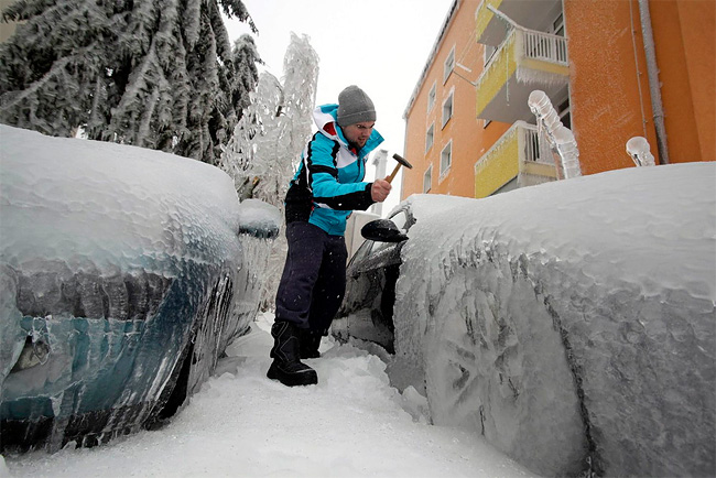
When you hear news of an ice storm, it is freezing rain. Ice storms can be the most devastating of winter weather phenomena and are often the cause of automobile accidents, power outages and personal injury.
Ice storms result from the accumulation of freezing rain, which is rain that becomes supercooled and freezes upon impact with cold surfaces.
![[freezing rain]](frz2.gif) The
diagram on the left shows a typical temperature profile for
freezing rain with the red line indicating the atmosphere's
temperature at any given altitude. The vertical line in the center
of the diagram is the freezing line. Temperatures to the left of
this line are below freezing, while temperatures to the right are
above freezing.
The
diagram on the left shows a typical temperature profile for
freezing rain with the red line indicating the atmosphere's
temperature at any given altitude. The vertical line in the center
of the diagram is the freezing line. Temperatures to the left of
this line are below freezing, while temperatures to the right are
above freezing.
Freezing rain develops as falling snow encounters a layer of warm air deep enough for the snow to completely melt and become rain. As the rain continues to fall, it passes through a thin layer of cold air just above the surface and cools to a temperature below freezing.
However, the drops themselves do not freeze. When the supercooled drops strike the frozen ground (or power lines, tree branches, etc.), they instantly freeze, forming a thin film of ice, hence freezing rain. A prolonged period of freezing rain, results in a thick layer of ice covering everything.
An intense ice storm can paralyze a region in a matter of hours, greatly affecting the people who live there. Freezing rain is dangerous because it is almost invisible on smooth surfaces and consequently, people are often unaware of its presence. Sidewalks and roadways become extremely slick and car accidents are common during an ice storm. Tree limbs and power lines, weighted down by accumulating ice, can snap.
![[freezing rain]](home1.gif) |
 |
| Freezing rain on tree branches | |
![[freezing rain2]](home2.gif) |
|
| Freezing rain on clothes line | Heavy Freezing Rain |
Sleet
Sleet is less prevalent than freezing rain and is defined as frozen raindrops that bounce on impact with the ground or other objects.
![[sleet]](slt3.gif) The diagram on
the left shows a typical temperature profile for sleet with the
light blue line indicating the atmosphere's temperature at any
given altitude. The difference here is that melted or partially
melted snowflakes fall through a much deeper layer of below
freezing air near the ground and freeze into little balls
of ice before hitting the ground.
The diagram on
the left shows a typical temperature profile for sleet with the
light blue line indicating the atmosphere's temperature at any
given altitude. The difference here is that melted or partially
melted snowflakes fall through a much deeper layer of below
freezing air near the ground and freeze into little balls
of ice before hitting the ground.
Sleet is more difficult to forecast than freezing rain because it develops under more specialized atmospheric conditions. It is much less troublesome than freezing rain because it is easy to see and is already frozen before hitting the ground.
Hail
Hail is precipitation in the form of spherical or irregular pellets of ice that fall from cumulonimbus clouds (thunderstorms). Hail does not form in the same way as sleet. Hailstones can become quite large and destructive. We will cover hail in assoication with the topic of severe thunderstorms.
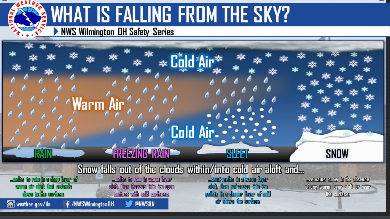
Below is a nice graphic from the NWS summarizing the below cloud conditions that lead to rain, freezing rain, sleet, and snow.