![[Home]](../../icons/home.jpg)
![[Lectures]](../../icons/lectures.jpg)
![[Previous]](../../icons/previous.jpg)
![[Next]](../../icons/next.jpg)
Hurricane Energetics
Hurricane Formation and Dissipation
The formation of tropical cyclones is still a topic of intense research
and is not fully understood, although research has shown that certain factors must
be present for cyclones to intensify to hurricane strength.
Hurricanes form over tropical waters where the winds are light,
the humidity is high in a deep layer, and the surface water
temperature is warm, typically 26.5°C (80°F) or greater,
over a vast area. Moreover, the warm surface water must extend
downward to a depth about 200 m (600 ft) before hurricane
formation is possible.
Hurricanes are powered by the latent heat energy released from
condensation. To form and develop they must be supplied with a
constant supply of warm humid air for this process. Surface air
with enough energy to generate a hurricane only exists over oceans
with a temperature greater than 26.5°C. Moreover,
the atmosphere above a developing storm must be unstable, i.e., the
temperature must decrease rapidly with increasing altitude. This is
condusive to thunderstorm formation in general.
Hurricanes cannot develop on or very near the Equator. In fact they do not form
in the region within 4° latitude either
side of the equator. Within this region Coriolis force is
negligible. Coriolis force is required for the initiation of
rotation. In fact it is relatively rare for hurricanes to form within 10°
of latitude from the Equator.
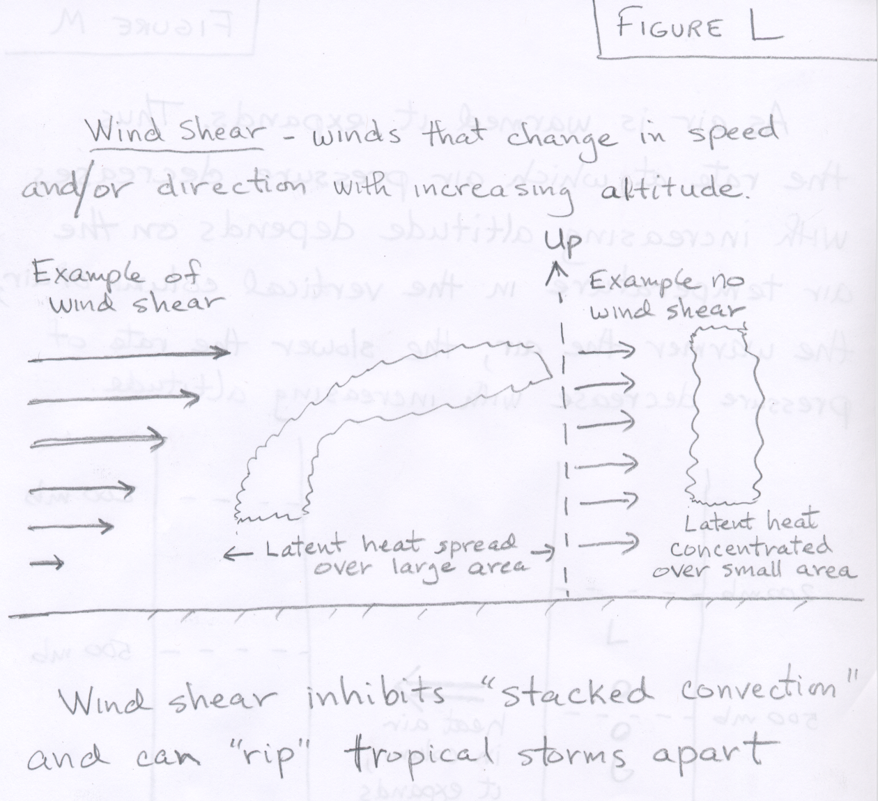
Finally, hurricanes will not form if there is significant wind shear, which
is a change in wind velocity and/or direction with increasing altitude
Hurricanes grow stronger as long as the air aloft moves
outward away from the storm center more quickly than the surface
air moves in toward the center.
They dissipate rapidly when they move over colder water
or over a large landmass as these conditions cut-off the supply of warm, humid air.
Hurricanes will also weaken if they move into an area that has strong
vertical wind shear.
Below is a summary list of five requirements for tropical storm
development and intensification.
- Warm, humid surface air and an unstable atmosphere
- Latent heat release during condensation is the driving energy for
tropical storm intensification.
- (a)Warm ocean surface waters (Temperature > 26.5°C [80°F]). This is
the "fuel" for hurricanes.
(b)Depth of warm water > 60 m (200 ft)
- As cyclone develops, winds churn up water, bringing up water from below the
ocean surface. If this water is too cold, hurricanes cannot develop.
- The warm water requirement explains why hurricanes are most common in the late
summer and early fall ... the time of the year when sea surface temperature is
greatest in the oceans where tropical storms originate.
- Pre-existing large-scale surface convergence and/or upper-level divergence
- For example, an area of low level convergence is present with easterly waves.
- Must be further than 4° Latitude away from the Equator
- In order to get winds to rotate counterclockwise around an area of low
pressure, there must be a Coriolis effect. The Coriolis force at the equator
is zero and gets larger as one moves toward the poles.
- Absence of strong vertical wind shear ( Figure L contains a
definition and sample picture of vertical wind shear).
- Wind shear inhibits deep convection, essentially ripping tropical storms apart.
Generally, tropical storms are best able to strengthen when the rising warm air near the
center of the storm goes straight up. Wind shear can cause the updrafts to bend
over, which is not favorable for the storm to strengthen.
- In contrast, vertical wind shear is necessary for the development of severe thunderstorms.
Only when all of these conditions are met do tropical cyclones develop into hurricanes.
In addition, once a hurricane has developed, if one or more of these five conditions go away,
the storm will usually weaken.
The Strengthening of hurricanes via a positive feedback loop
In this section, the energetics of how tropical cyclones
intensify to become hurricanes is discussed using a simple process diagram.
When conditions are just right, tropical storms intensify
via a positive feedback loop. Before looking at the process diagram, there are a couple of pieces
of background material to review. One concerns the relationship between horizontal convergence
and divergence of air flow and forced rising and sinking motion, which is described in this
scanned version of dynamical forcing handout.
The important concepts are that converging air at surface and diverging air near the top of the
tropopause both force rising vertical air motion.
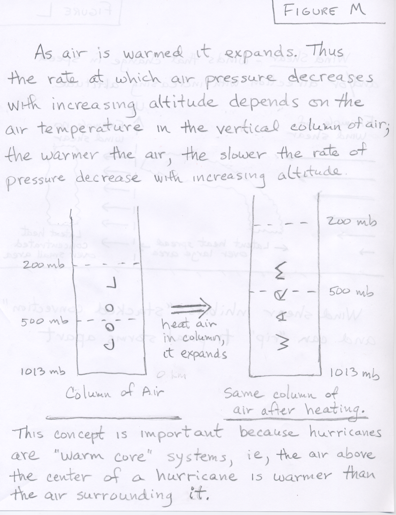
Additionally, let's review the relationship between the air temperature in a
vertical column of air the rate of pressure decrease with height in that column
(See Figure M). Remember air pressure must decrease as you move upward.
The rate at which pressure decreases (for example pressure drop per 1000 meters of moving upward) is
smaller in warm air (warm core of a hurricane for example) compared with colder air.
We should now have enough background knowledge to understand the figure below and the basic
description of some of the energetics of hurricane strengthening beneath the figure
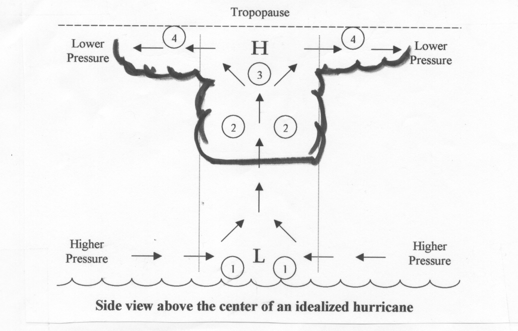
This is a simplified sequence describing some of the energetics involved in hurricane strengthening.
The numbers in the diagram above correspond with the steps listed.
- Assume a pre-existing area of low level convergence. The 'L' represents a region of surface low pressure.
The air flow near a surface low is counterclockwise and converging. The converging part is indicated by the
arrows just above the ocean surface. We also assume that ocean water is warmer than 80°F to a depth of
at least 200 feet and there is little vertical wind shear.
- As surface air converges, air is forced to rise. As air rises upward, it expands and cools.
Once the air is cooled to saturation, clouds begin to form. This condensation releases tremendous
amounts of latent energy, warming the air in the column above the surface low. This forms the warm core of the system.
- As the column of air above the surface low warms, the rate at which pressure falls with increasing altitude decreases.
Thus, relatively high pressure forms in the upper troposphere, labeled with 'H'.
(Note that outside of this warm column, pressure falls more rapidly with increasing altitude).
- This relatively high pressure at the top of the troposphere compared to the lower pressure surrounding it,
results in strengthening divergence (outflow) at the top of the storm.
- When outflow (divergence) of air at the top of the column is greater than the inflow (convergence) of air at the bottom
of the column, more air is being removed from column (at top)
than is added (at bottom). This results in a loss of weight of air in column.
Thus, surface pressure lowers at the bottom of the column,
since the air pressure at the surface is caused by the weight of air above.
- Lower surface pressure means the storm is intensifying as this results in stronger surface winds.
- Stronger surface winds bring in more "fuel" (water vapor) to the storm. The lower surface pressure increases
convergence and rising motion. In addition, higher winds increase the net rate of evaporation from the ocean. As
winds and waves increase, a lot of sea spray is kicked up into the air.
This provides additional surface area for evaporation.
- As more water vapor is brought into storm, more latent heat released, further warming column of air above the surface low.
This step feeds back to step #3 above, and the storm can continue to strengthen in this manner
through a positive feedback cycle.
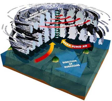
This simplified positive feedback cycle cannot continue indefinitely. Strong hurricanes tend to go through
cycles of intensification and weakening during their lifetimes. The figure below shows a more
realistic look at anatomy of a hurricane. As opposed to the
simple explanation for intensification which only showed a central updraft, real hurricanes
have banded structures of rising and sinking motion.