![]()
![]()
![]()
![]()
![[tornado]](tornado.jpg)
|
![[tornado]](tornado2.jpg) |
Each year, tornadoes take the lives of many people. The yearly average is about 100 (60 in the United States), although over 100 may die in a single day. The deadliest tornadoes are those that occur in families; that is, different tornadoes all spawned within a region with favorable atmospheric conditions for tornado development.
When a large number of tornadoes (typically 6 or more) forms over a particular region, this constitutes a tornado outbreak. One of the most violent occurred on April 3 and 4, 1974. During a 16 hour period, 148 tornadoes cut through parts of 13 states, killing 307 people, injuring more than 6000, and causing an estimated $600 million in damage.
Tornadoes occur in many places of the world, but no country experiences more tornadoes than the United States, which averages more than 1000 annually and experienced a record 1424 tornadoes during 1998. Surprisingly, central Florida experiences the greatest number of tornadoes. However, most of the tornadoes that occur in Florida are weak and cause relatively minor damage and few deaths.
While tornadoes have occurred in every state the greatest number of strong tornadoes, those that cause extensive damage and are responsible for the largest share of deaths, occur in the tornado belt or tornado alley of the Central Plains, which streches from central Texas northward through Oklahoma and Kansas to Nebraska and includes parts of Colorado, Iowa, Illinois, Missouri, and Arkansas.
About three-fourths of all tornadoes in the United States develop from March to July. Although tornadoes have occurred at all times of the day and night, they are most frequent in the late afternoon, when the surface air is most unstable.
Tornado days per year![[all tornadoes]](ttor8094.gif)
|
Significant (F2 or larger Tornado days
per century![[significant tornadoes]](sigt2195.gif)
|
Violent (F4 or larger) Tornado days
per millennium![[violent
tornadoes]](viot2195.gif)
|
The strong winds of a tornado can destroy buildings, uproot trees, and hurl all sorts of lethal missiles into the air. Our earlier knowledge of the furious winds of a tornado came mainly from observations of the damage done and the analysis of motion pictures.
In the late 1960s, the late Dr. T. Theodore Fujita, a noted authority on tornadoes at the University of Chicago, proposed a scale (called the Fujita scale for classifying tornadoes according to their rotational wind speed based on the damage done by the storm.
| Scale | Category | Mi/Hr | Expected damage |
|---|---|---|---|
| F0 | Weak | 40-72 | light: tree branches broken; sign boards damaged |
| F1 | 73-112 | moderate: trees snapped, windows broken | |
| F2 | Strong | 113-157 | considerable: large trees uprooted, weak structures destroyed |
| F3 | 158-206 | severe: trees leveled, cars overturned, walls removed from buildings | |
| F4 | Violent | 207-260 | devastating: frame houses destroyed |
| F5 | 261-276 | incredible: structures the size of autos moved over 100 meters, steel reinforced structures highly damaged |
| Characteristic | Most Common | Extreme / Possible |
|---|---|---|
| Location on Earth | United States | Nearly Anywhere |
| Time of year (USA) | May - July | Any month |
| Time of day | 4 - 6 PM | Any time |
| Size (diameter) | 50 yards | > 1 mile |
| Movement-speed | 30 mph | 0 - 70 mph |
| Movement-direction (USA) | Toward Northeast | Any Direction |
| Length of Ground Path | < 2 miles | > 300 miles |
| Time on Ground | < 5 minutes | > 6 hours |
| Wind Speed | < 100 mph (F0,F1) | > 300 mph (F5) |
Most tornado-related deaths and injuries are caused by flying debris, so the most important consideration is to shelter yourself from flying debris. If possible go to a sturdy structure. Your best bet is to move into a basement or underground storm shelter. If these are not available go to an interior closet away from windows. Cars and mobile homes are not sturdy structures and are dangerous locations to wait out a tornado. If you are caught outside, you want to get as low to the ground as possible. Your best bet is to lie flat in a ditch or depression in the ground.
Ingredients necessary for tornado formation:
1. An unstable atmosphere that is capable of producing strong thunderstorm updrafts and downdrafts.
2. A lifting force. The most common lifting forces are heating of air near the surface and weather fronts.
3. Vertical wind shear to provide rotation.
The exact sequence of events that lead to tornadoes are not fully understood. Although meteorologists can locate regions where the conditions are more favorable for tornado development (based on the ingredients above), the exact location and time cannot be predicted accurately. When favorable conditions are present over a particular region, a tornado watch may be issued.
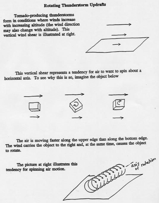
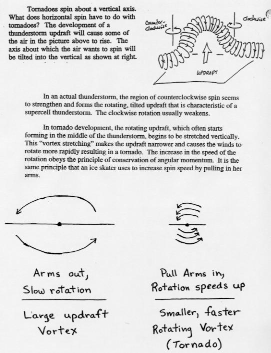
The leading theory of tornado formation involves rotating thunderstorm updrafts. The two pages listed below will also be distributed as part of an in-class handout. ( formation page 1, formation page 2).
Tornadoes come and go so quickly and are so small that predicting where and when one will hit more than 15 to 30 minutes ahead of time is not possible. The average warning time for a tornado with winds of 158 miles an hour or faster - the type that accounts for most deaths - is 18 minutes. Of course if the tornado forms right on top of you, then in some cases no warning can be given. Tornadoes can be detected with Doppler Radar and when they are, tornado warnings are issued. All weather radars work by measuring the reflected (or more correctly backscattered) radiation coming from large particles such as raindrops and hail. Doppler radars can also detect whether the reflecting particles are moving toward or away from the radar site. Thus, the rotating winds around a tornado can show up very well on Doppler Radars. Sometimes the rotation can be observed at cloud level,and a tornado warning issued, before the tornado circulation touches down on the ground.
Why is the favored region for strong tornado formation in the central plains states (often referred to as TORNADO ALLELY)? Severe tornadoes often form when three very different types of air come together in a particular way. Near the ground surface southerly or southeasterly transport warm, humid air from the Gulf of Mexico into the Plains.
![[capmap]](capmap2.jpg) |
The existence of the mid-level convective cap, which will be referred to as an inversion layer, is a key ingredient. An inversion layer is a layer in the atmosphere where the temperature increases with increasing height. Recall that typically temperature decreases with increasing height. An inversion layer is extremely stable for rising motion. At first an inversion layer will inhibit thunderstorm formation because rising parcels from the surface will not be able to penetrate through this layer. However, as the day progresses and the atmosphere gradually warms from below the inversion layer erodes away, and surface parcels become warm enough to "break through" the old inversion layer and reach the unstable atmosphere above. All day the sun's energy was used to heat the lower atmosphere and increase the water vapor content by evaporation essentially adding more energy to the lower atmosphere. When parcels are finally able to "break through", it is like blowing the lid off of a pressure cooker. An illustrative diagram of a convective cap will be drawn in lecture.
A very comprehensive explanation behind the formation of tornadoes is given in the NOAA web page: tornadoes... Nature's Most Violent Storms A PREPAREDNESS GUIDE Including Safety Information for Schools U.S. DEPARTMENT OF COMMERCE National Oceanic and Atmospheric Administration National Weather Service September 1992 (NOAA, FEMA, The American Red Cross).
Links to the Historical Tornado Data Archive hosted by the STORM PREDICTION CENTER
![]()
![]()
![]()
![]()