![]()
![]()
![]()
![]()
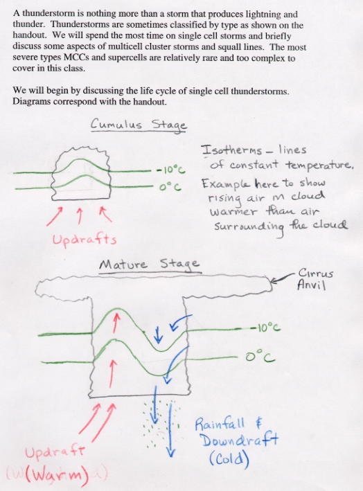
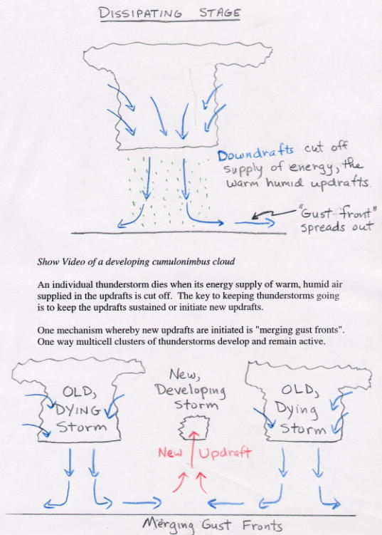
A thunderstorm is simply a storm that produces lightning and thunder. Some thunderstorms never produce precipitation. Thunderstorms are sometimes classified by type as shown on an in-class handout. This classification system is somewhat arbitrary, though, and not every thunderstorm will fit exactly into a single category. Most thunderstorms are not severe and would be classified as the single cell type. Fortunately, the most severe thunderstorms, the mesoscale convective complexes and supercells, are relatively rare. These most severe storms are quite complex and not fully understood. There would be no way to cover the details of those storms in a class like this. We will instead focus on the lifecycle of a typical single cell thunderstorm, then go on to discuss a couple of the mechanisms that allow some thunderstorms to become more organized and severe. The material should provide a basic understanding of thunderstorm development, however, you need to realize that not every thunderstorm will fit the idealized descriptions presented.
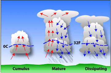 |
| Simplified model depicting the life cycle of an ordinary thunderstorm that is nearly stationary. (Arrows show vertical air currents. Dashed line represents freezing level, 0°C isotherm.) |
All thunderstorms require instability (potential) and lift. The lift is the mechanism that releases the instability. Lift is produced by such things as fronts and low pressure troughs, or by air rising upslope.
We say that the atmosphere is unstable when air rising in a cloud is warmer than its environment, like a hot-air balloon. It is the heat released by condensation within a cloud that permits the rising air to stay warmer than its surroundings, and thus to be buoyant through great depths.
In the same way, air that is cooler than its environment tends to sink as long as it can stay cooler than its surroundings.
The upward moving air in a thunderstorm is known as the updraft, while downward moving air is the downdraft. The atmosphere can be unstable for updrafts but stable for downdrafts, stable for updrafts but unstable for downdrafts, stable for both, or unstable for both. The degree of atmospheric instability is one of the two major factors in determining the strengths of thunderstorm updrafts and downdrafts.
When the low-level air is unstable but relatively dry and adequate mid-level moisture is present, a storm may develop with a weak updraft but a strong downdraft with the latter the result of strong negative buoyancy and cooling through evaporation of precipitation into the dry air. This high-based storm resembles high terrain, western U.S. storms which occasionally produce dry microbursts. Significant hail and rain are unlikely.
A storm which contains a strong updraft and weak downdraft; will not produce wind damage, but can foster heavy rains and/or damaging hail. Single and multicell storms comprise this category. They include storms that dump heavy rain, but little or no hail because of warm conditions aloft, and multicell storms that are capable of producing hail because of lower environmental freezing levels. Strong updraft, weak downdraft storms often form in very moist atmospheres where there is little, if any, dry air and evaporational cooling to drive downdrafts.
Relatively weak updrafts and downdrafts are found with non-severe showers and thunderstorms. The last possible combination is a storm with strong updrafts and downdrafts. These storms frequently produce destructive downbursts, hail, heavy rain, and tornadoes. As one would expect, the most severe storms, including supercells, have strong vertical updrafts and downdrafts and occur in the most unstable atmospheres.
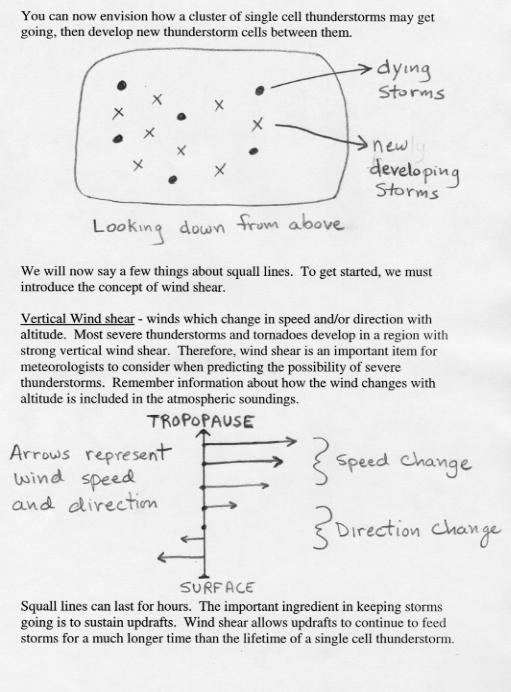
Severe thunderstorms most often form in areas with strong vertical wind shear.
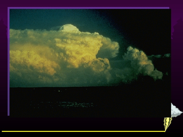 |
| Supercell thunderstorm. The powerful main updraft can be seen by the presence of an overshooting top above the anvil. Photo by Howard Bluestein. |
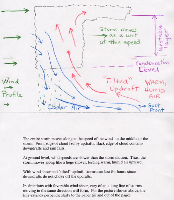
Vertical wind shear is the second critical factor in the determination of thunderstorm type and potential storm severity. Vertical shear, or the change of winds with height, interacts dynamically with thunderstorms to either enhance or diminish vertical draft strengths.
Thunderstorms which occur in weak vertical wind shear usually have an erect appearance. These storms don't last as long as strong storms in a sheared environment since the rainy downdraft quickly undercuts and chokes off the updraft. If any severe weather occurs with these weak-shear storms, it will be brief, occurring just prior to dissipation.
We refer to storms in sheared environments as organized convection. Organized storms are longer-lived, usually have preferred areas of new updraft development, and often allow for some predictability of periodic severe weather events.
When the atmosphere is extremely unstable with just the right type of wind shear, supercell thunderstorms can form. In most supercell thunderstorms, the strong updraft will rotate counterclockwise as the air rises. Updraft speeds may reach over 100 mph. The storm organizes itself so that the rain, hail and subsequent downdrafts remain isolated from the rotating updraft, which allows the storm to remain violent for an extended period of time. Supercell thunderstorms often produce damaging microbursts, large hail, and torrential rains. Most monster tornadoes are born in supercell thunderstorms. Supercell storms can often be identified by the presence of a "dome cloud" extending above the main cloud mass (see picture on left). The dome is the result of strong updrafts "overshooting" the level where it would otherwise stop rising (i.e., where temperature of lifted parcels are no longer warmer than the surrounding air). A good, non-technical article about supercell formation is available from USA Today: Supercells are the Kings of Thunderstorms. Schematic diagrams of supercell thunderstorms are shown below. Don't worry, you are not expected to understand the details in the diagrams.
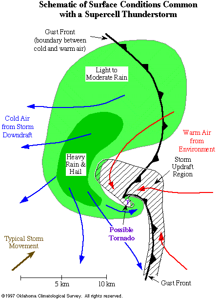 |
| This schematic looks down from above and displays typical surface conditions associated with a mature supercell thunderstorm. Note that the updraft and downdraft (rain area) regions are separated physically. In this manner, the supercell can exist in a quasi-steady-state for a few hours. |
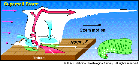 |
| This diagram shows the structure of a mature "supercell" thunderstorm. (The vertical scale is exaggerated so that details of the cloud structure can be shown.) Pink arrows indicate the winds at various heights in the atmosphere. Red arrows are updrafts; blue arrows are downdrafts. Note that because wind speeds increase with height, rain falls away from the updraft, allowing the storm to be maintained for hours. Supercell thunderstorms are significantly more destructive than ordinary thunderstorms. |
Meteorologists responsible for forecasting where thunderstorms will form and how severe they may become pay close attention to two main factors: stability of the atmosphere, and wind shear. In order for thunderstorms to form, air parcels must rise up and become unstable. The larger the vertical extent of the unstable layer and the warmer rising parcels are relative to the temperature of the surrounding atmosphere, the stronger the storms can become. Vertical wind shear, changes in wind direction and windspeed with increasing altitude, can allow convection to become organized, longer-lived, and more violent (as opposed to the rapid life cycle of single-cell storms). In organized convection, the updraft region of a storm is able to remain isolated from the precipitation and subsequent downdrafts. In single-cell thunderstorms, rain and downdrafts falling into the updraft cut off the storm's fuel supply of warm, humid air.
The temperature, water vapor, and wind profiles of the atmosphere are measured twice daily (at 00Z and 12Z) from each weather station around the globe. This includes the Tucson airport, which is a weather station site. Measurements are taken by instruments attached to weather balloons that are released from the ground and rise upward. Between the routine observations, the temperature, water vapor, and winds are estimated by computer weather forecast models. Meteorologists must assess this available information when forecasting the possiblity of severe thunderstorms.
![[microburst]](microburst.jpg)
|
| Spreading microburst in the desert. |
![]()
![]()
![]()
![]()