![]()
![]()
![]()
![]()
The Earth contains many different climate types. From the teeming tropical jungles to the frigid polar wastelands, there seems to be an almost endless variety of climatic regions. There are many factors that determine or control the climate in any given place. Perhaps the most obvious and strongest influencing factor on climate is the yearly variation in the amount of solar energy received from the sun. This varies with latitude and time of year giving rise to what are termed "seasonal changes". Click here for a simple picture of latitude on Earth. The severity of seasonal changes during a year, from summer to winter, depends strongly on the latitude where you live. There are only small seasonal changes in temperature at lower latitudes (near the equator) with increasingly larger seasonal changes in temperature at higher latitudes (toward the north and south pole).
Two observable "seasonal changes" that take place during a calendar year at a given location on Earth (latitude) are: (1) changes in the intensity of sunshine received and (2) the changes in length of daylight hours. These astronomical changes give rise to variations in temperature throughout the year. The severity of seasonal changes is not the same at all latitudes. Seasonal changes in temperature at the equator and throughout the tropics are minor. As you move further away from the Equator, seasonal changes become more severe, and the largest seasonal changes occur at the north and south poles and throughout the Arctic and Antarctic regions. The explanation for seasonal changes is based on the geometry of Earth's yearly orbit about the Sun relative to the Earth's daily rotation. Surprisingly, most people in the United States (including college graduates) cannot explain it.
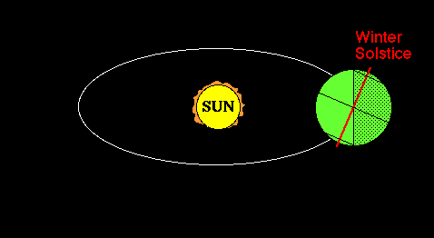
If you trace the path of the Earth as it orbits the Sun, it falls within a plane called the ecliptic plane. Don't be scared by the terminology. All this means is that the Earth remains in a plane as it orbits around the sun. Each time around takes one year (about 365.25 days). The second thing we need to define is the Earth's axis of rotation. The axis of rotation is an imaginary line which extends through the Earth's north and south poles. The Earth spins (or rotates) about this axis, making one complete rotation each day (24 hours). Seasons on Earth occur because the axis of rotation is not perpendicular to the ecliptic plane since this causes the distribution of solar energy around the globe to change during the year. Currently, the axis of rotation is 23.5° away from perpendicular (see Figure 16). This is what is meant by the statement: "the Earth is tilted on its axis". To understand how this results in seasonal changes, you must realize that the orientation between the ecliptic plane and the axis of rotation does not change as the Earth orbits the Sun. I suggest that you check out the following Earth revolution animation. The animation shows that the Northern Hemisphere is tilted toward the sun on the summer solstice and that the southern hemisphere is tilted toward the sun on the winter solstice, which indicate the seasonal extremes. On both the Vernal (Spring) and Autumnal (Fall) Equinoxes, the earth is not tilted toward or away from the sun, the sun shines directly on the equator and both hemispheres receive equal sunshine.
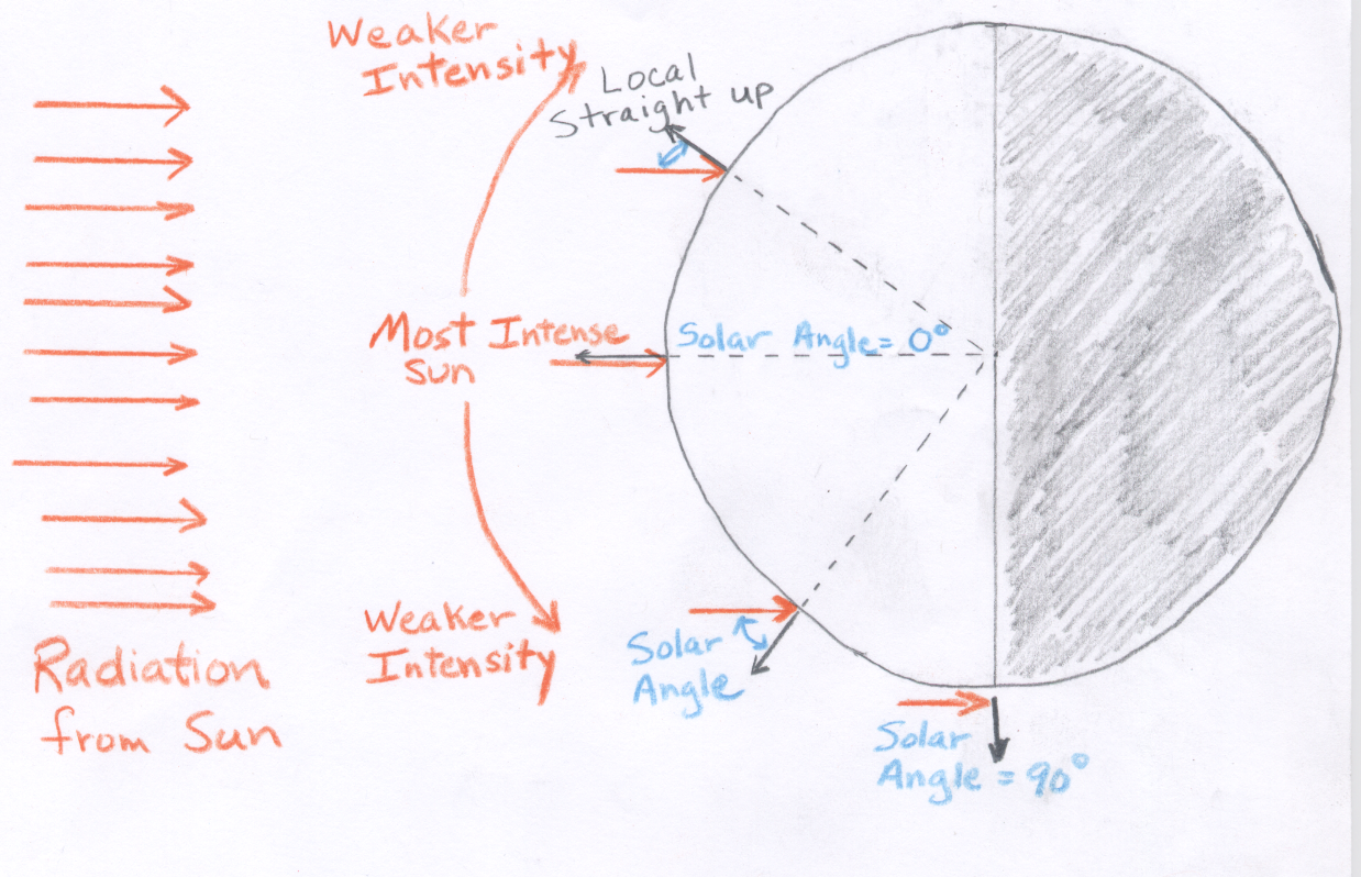
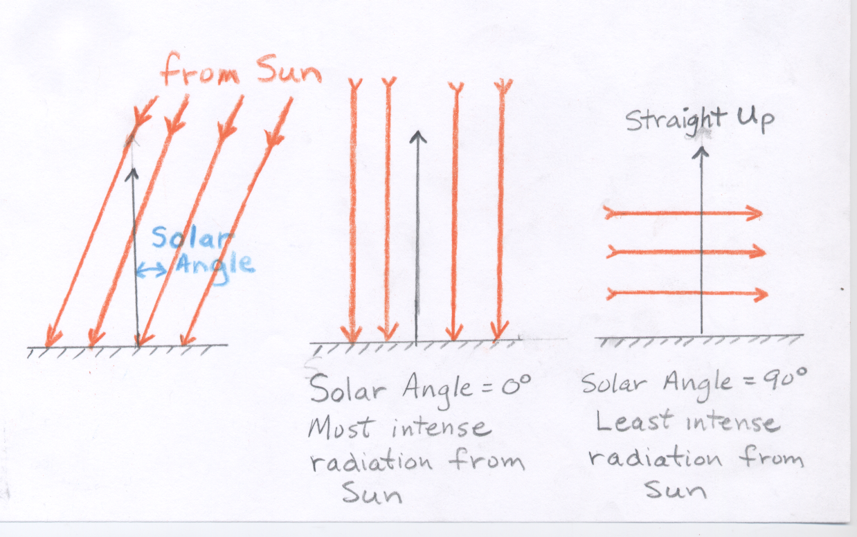
Because the Sun is so far away from the Earth and the Earth intercepts only a tiny fraction of all the radiation energy coming from the Sun, it is a fairly good approximation to say that all the energy from the Sun is coming from a single direction. Since the Earth is a sphere this means that at any given instant, there is only one point on the Earth where the Sun's rays are striking perpendicular to the surface (See Figure 15). In other words, at any given instant there is only one place (point) where the Sun is directly overhead or straight up. The further you move away from this one point, the further away you need to look from straight up to see the Sun. In this class, we will use the term solar angle to define the angle between the direction to the Sun and straight up (See Figure 14). Therefore, when the Sun is straight up, the solar angle is 0°, and when the Sun is on the horizon, the solar angle is 90° .
Solar angle is important because the energy received from the Sun is most intense where it hits perpendicular to the surface (solar angle = 0°). As the solar angle gets larger, the energy received from the Sun becomes less intense. Again, don't be confused by the terminology. We experience this effect each day. Think of how "strong" the Sun feels at sunrise (when the solar angle is large), compared to noon (when the solar angle is much smaller). At any day and location Solar Noon is defined as the exact middle of the daylight period or when the sun is halfway between sunrise and sunset. At solar noon, the Sun is aligned with true north and south. Note that solar noon does not necessarily occur at precisely 12 PM local time, though it is usually close. No matter where you are on Earth, solar noon is when the solar angle reaches its daily minimum. Outside of the tropics, you know that the noon-time sun "feels stronger" in summer as compared to winter. Therefore, the solar angle must be smaller in summer as compared to winter. This seasonal change results from the geometry of Earth-Sun orientation described above. The changes of sun angle with time of year and latitude are quantified below.
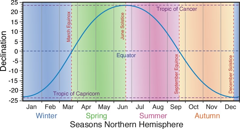
The solar declination or sub-solar point (shown graphically above) is defined as the LATITUDE at which the sun is directly overhead at solar noon. The solar declination is found at only one latitude each day. The solar declination changes slowly from day to day and ranges from 23.5°N Latitude (called the tropic of Cancer) on the summer solstice, which happens around June 21 each year, to 23.5°S Latitude (called the tropic of Capricorn) on the winter solstice, which happens around December 21 each year. This latitudinal boundary defines the tropics, which is the region between 23.5°N Latitude and 23.5°S Latitude, where the noontime sun is directly overhead at least one day per year. Other notable dates include, the spring equinox, which happens around March 21 each year, and fall equinox, which happens around September 21. On these days the noon-time sun is directly overhead at the equator. You should know the position of the solar declination on the equinox and solstice dates as indicated in the diagram above. You should be able answer these questions:
You should understand the following observations.
It is easy to compute the solar angle at noon for any latitude and any day of the year (and you may be asked to do this in exam or homework material). At local solar noon, the sun is always located along a north-south line. The solar angle at noon is simply equal to the number of degrees of latitude between your latitude (your position on Earth) and the latitude of the solar declination. If the solar declination is to the north of your location, then you will have to look toward the north to see the sun at solar noon; if the solar declination is to the south of your position, the you will have to look toward the south to see the sun at solar noon.
Example.
What is the noon-time solar angle in Tucson (latitude = 32°N) on the following three dates:
(a)the Summer solstice;
(b)the Spring Equinox;
(c)the winter solstice?
ANSWERS:
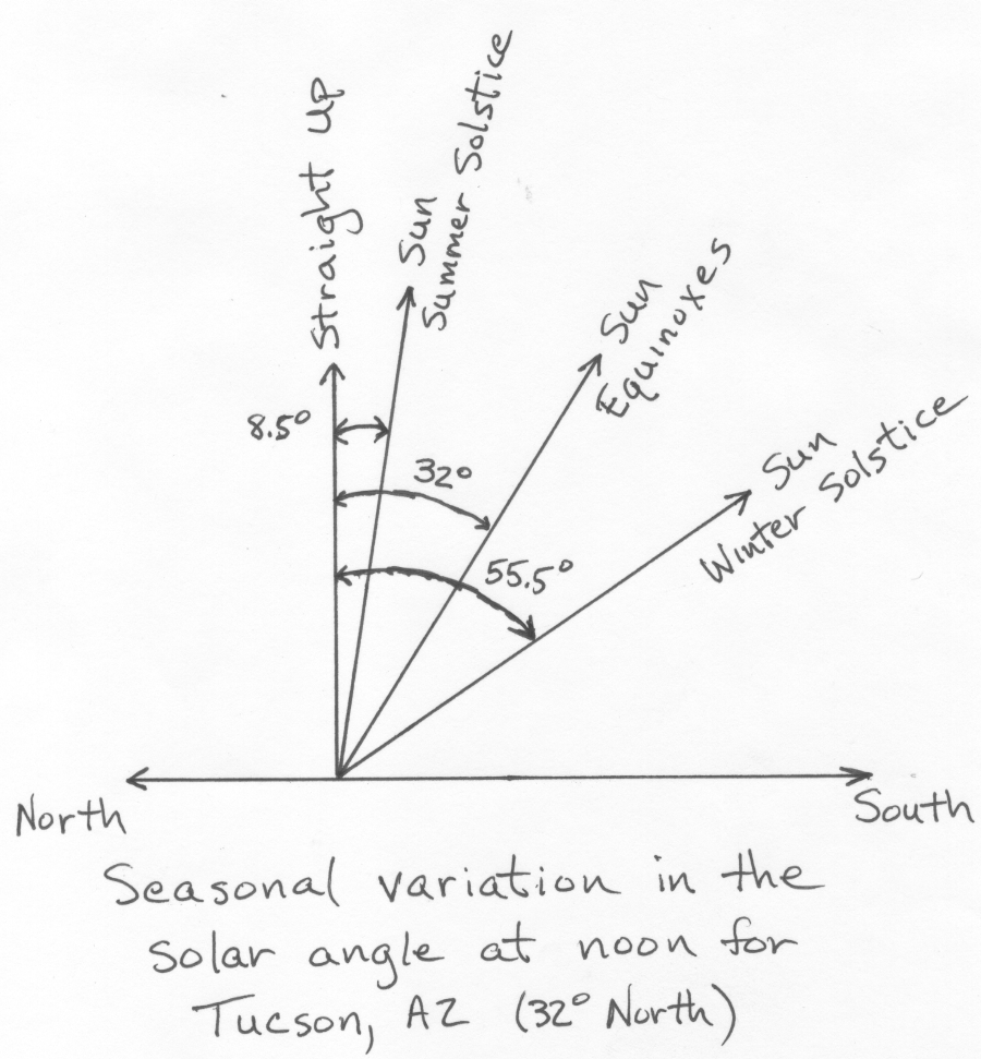
(a)8.5° toward the south (there are 8.5° of latitude
between 32°North and the position of the solar declination at 23.5°North)
(b)32° toward the south (there are 32° of latitude between Tucson
and the Equator, which is the position of the solar declination on Equinox days at 0° latitude)
(c)55.5° toward the south (One has to move 32° of latitude to get from Tucson to the Equator, then another
23.5° to get to the solar declination which is located over the tropic of capricorn at 23.5° South latitude).
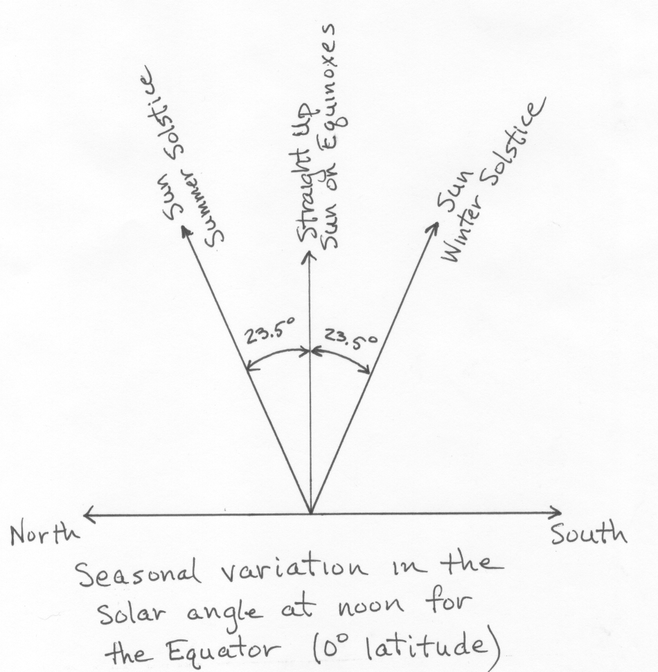
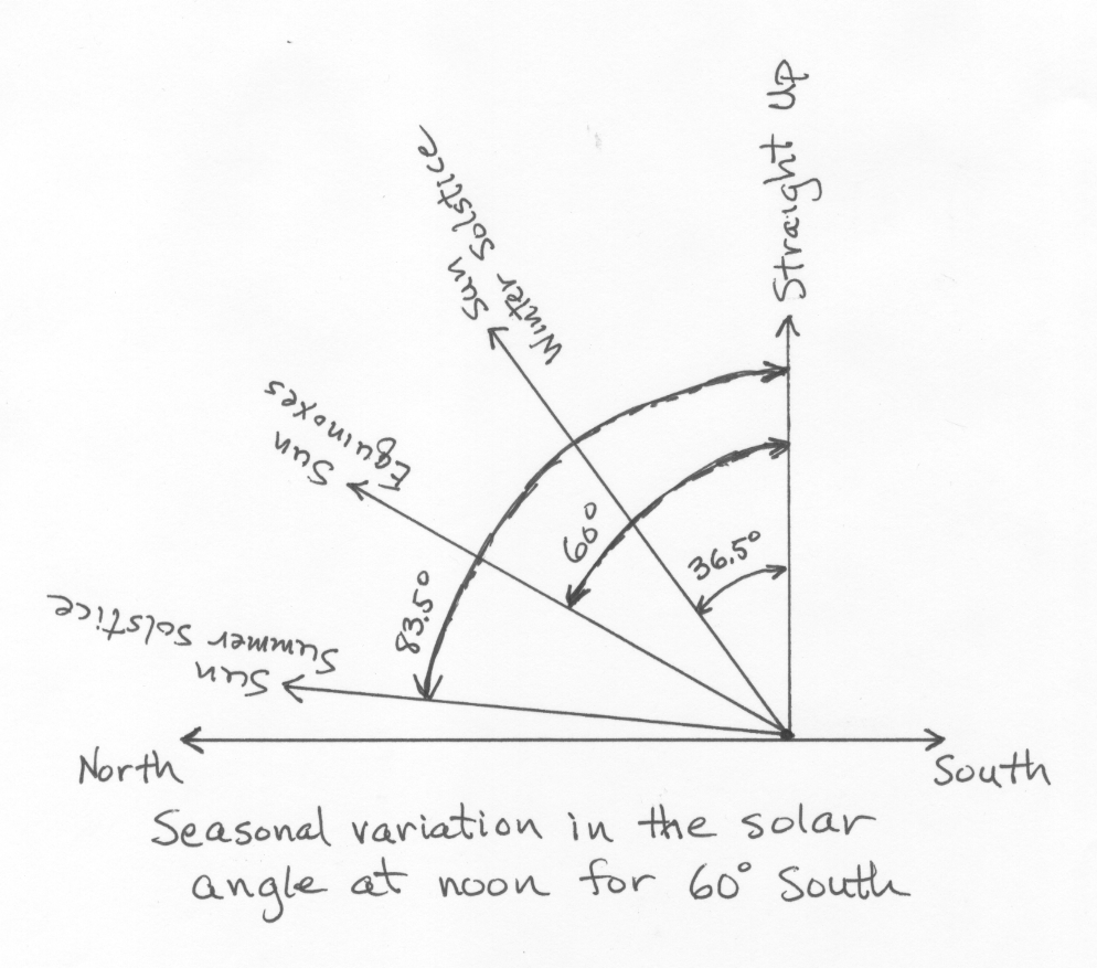
Because the solar declination is always located to the south of Tucson, the position of the sun at solar noon will always be south of straight up (Figure showing the seasonal variation in solar angle at noon for Tucson). The seasonal variation in solar angle at noon depends upon your latitude. You should be able to verify the yearly extremes in solar angle at noon for the Equator (0°Latitude) and for a location at 60°South latitude as shown in the following figures: Seasonal variation in solar angle for the Equator and Seasonal variation in solar angle for a location at 60°South latitude.
The yearly change in the solar angle at noon at a given latitude results in a corresponding change in the intensity of the sunlight received. The intensity of the sunlight is reduced by the cosine of the solar angle. (If you do not understand the last sentence about the cosine of an angle, don't worry, it is not something that I will test you on. You need to know the result given in bold below.) The seasonal or yearly change in the intensity of the sun at solar noon at a given latitude can be determined by comparing the intensity on the day of minimum solar angle at noon (largest cosine and greatest intensity) to the day of maximum solar angle at noon (smallest cosine and least intensity). The result is seasonal (yearly) changes in the intensity of the sun (and hence heating from the sun) are smallest at the Equator and get larger toward the north and south poles. This means that in the lower latitude tropics, there are only slight changes in solar heating and temperature during the year, and there are not distinct warm summers and cold winters. At higher latitudes the temperature difference between summer and winter becomes more distinct. Near the north and south poles, the change in solar intensity and temperature between summer and winter is extreme. You do not need to be able to do these calculations, but if you compute the ratio of maximum to the minimum cosine of the solar angle at noon for the three latitudes in the figures above, you can easily see that seasonal changes in the intensity of the sun and therefore in temperature are small at low latitudes and large at high latitudes. For Tucson (32° latitude) this ratio is 1.74 [cosine(8.5°)/cosine(55.5°)], which means the sun is 1.74 times (almost twice as much) more intense on the summer solstice as compared to the winter solstice, which is a 54% variation over the year relative the the average. For a latitude of 60° the ratio is 7.27 [cosine(36.5°)/cosine(83.5°)], which means the sun is more than 7 times more intense on the summer solstice as compared to the winter solstice and there is 151% yearly variation relative to average. Finally, at the Equator the ratio is 1.09 [cosine(0°)/cosine(23.5°)], which is a variation of less than 9% over the year.
The second factor which regulates seasonal changes in the amount of solar radiation energy that strikes a particular location (latitude) is the length of daylight or the number of hours from sunrise to sunset. I'm sure most of you know that the number of hours of daylight is longer in the summer as compared to the winter. More hours of daylight translates to more hours of heating from the sun. As with solar angle at noon, there are mathematical formulas which one can use to calculate the number of daylight hours at any latitude for any day of the year, but the calculations for length of day are complex, and we will not use them. It is important that you understand the this general statement the seasonal (yearly) changes in length of daylight hours are smallest at the Equator and get larger toward the north and south poles. In the northern hemisphere the longest day of the year is the summer solstice and the shortest day of the year is the winter solstice, while in the southern hemisphere the dates of the longest and shortest days are reversed. The figure below shows how the length of day changes at several different latitudes. At the Equator every day of the year is exactly 12 hours long. At 35° latitude the longest day is 14.5 hours and the shortest day 9.5 hours. At 50° latitude the longest day is 16.5 hours and the shortest day 7.5 hours. At latitudes of 66.5° and higher, the longest day of the year is 24 hours and the shortest day has 0 hours of sunlight. Note that at 90°N (north pole) the length of day is zero hours from September 21 to March 21 and 24 hours from March 21 to September 21 (unfortunately, the magenta line for 90°N did not show up on the plot in that section, but it should connect the ends and run across the graph at 24 hour days). In a sense this is like one long day per year ... 6 months of darkness followed by 6 months of sunlight.i Please also note that March 21 (Spring or Vernal Equinox) and September 21 (Fall or Autumnal Equinox), every latitude on Earth has exactly 12 hours of sunshine and 12 hours of darkness. The happens on these two specific dates when the axis of rotation does not point at all toward or away from the Sun. In fact the term "equinox" means equal day and night.
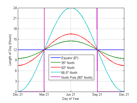
On the summer solstice, all places north of 66.5°N latitude (called the Arctic circle) have 24 hours of sunshine, while all places south of 66.5°S latitude (called the Antarctic circle) have 24 hours of darkness. Look at the animation below. Three lines of latitude are shown on the Earth, the Equator, the Arctic circle in the northern hemisphere and the Antactic circle in the southern hemisphere. Notice that on the summer solstice the entire Arctic region from the Arctic circle to the north pole is completely in sunshine, while the entire Antarctic region from the Antarctic circle to the south pole is completely in darkness even as the Earth rotates around its axis of rotation. Converselsy, on the winter solstice, all places north of 66.5°N latitude (called the Arctic circle) have 24 hours of darkness, while all places south of 66.5°S latitude (called the Antarctic circle) have 24 hours of sunshine. This is also shown in the animation below. Notice that on the winter solstice the entire Arctic region from the Arctic circle to the north pole is completely in darkness, while the entire Antarctic region from the Antarctic circle to the south pole is completely in sunshine even as the Earth rotates around its axis of rotation. In fact, this defines the Arctic and Antarctic regions, which are regions between 66.5° and 90° latitude where there is at least one day with 24 hours of sunshine and one day with 24 hours of darkness each year.
You should understand the following general observations about the length of day:
The last two observations are shown in these links:
longest day and longest night at different latitudes and
length of day during year for different latitudes.
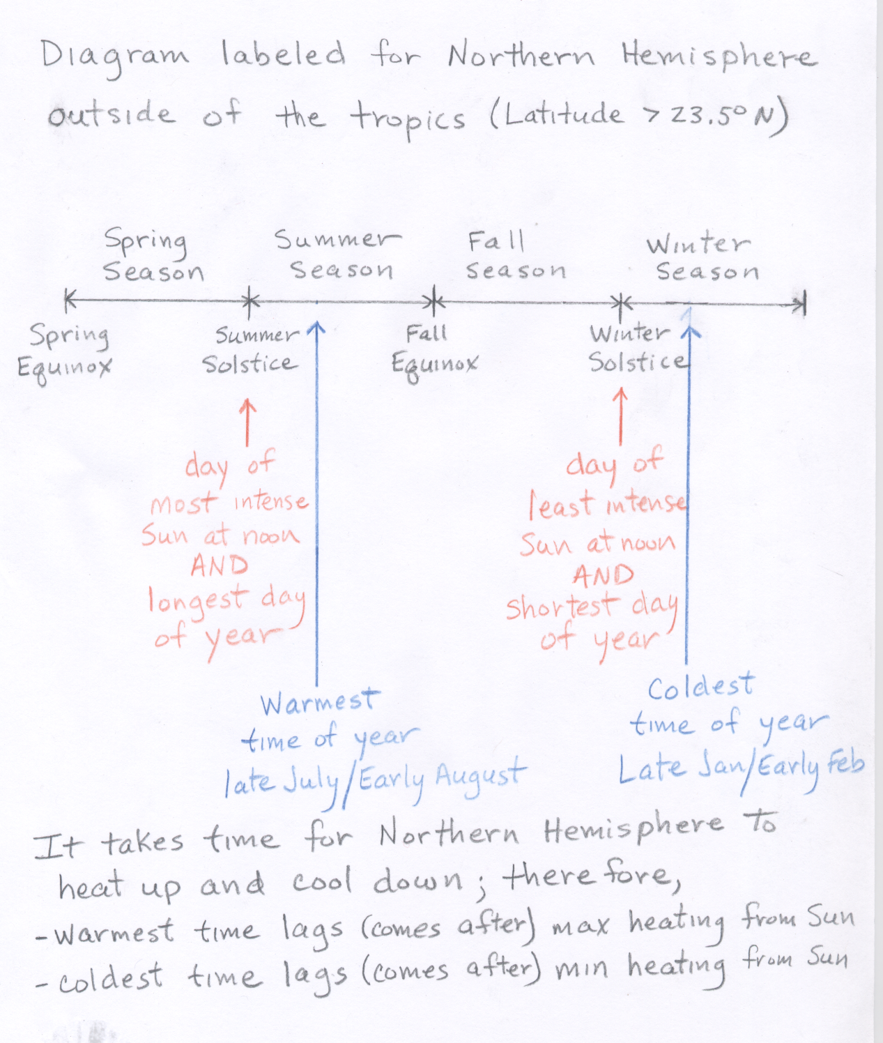
The above description of seasonal changes in the intensity and duration of sunshine are probably different from what you are used to. For example, the "summer season" is popularly defined as the season extending from the summer solstice (around June 21) through the fall equinox (around September 21). (See Declination and Northern Hemisphere Seasons) As we have seen, the day of maximum solar intensity (or maximum solar heating) in the northern hemisphere occurs on the summer solstice. You may wonder why summer solstice is not typically the warmest time of the year. The reason is that there is a lag between the maximum solar heating and the warmest time of the year. In the northern hemispere, the warmest temperatures generally occur near the end of July and the beginning of August, even though the maximum heating from the sun happens on the summer solstice (around June 21).
To understand the lag between maximum solar heating and maximum temperatures, you must consider our simple relationship between energy transfer and temperature that we covered in a previous lecture, which states that when energy input is greater than energy output, an object will warm. It takes some time for Earth's surface (land and ocean) to warm up from winter to summer. This is especially true for the oceans, which have a large thermal inertia, where temperature changes are slow in response to changes in radiational heating and cooling. Even though the Sun's heating is most intense on the summer solstice, energy input to the northern hemisphere remains greater than energy output until about the beginning of August. Therefore, the warmest time of the year in the northern hemisphere does not happen on the summer solstice, but lags the summer solstice by just over one month. This lag includes both ocean and land temperature. There is even a larger lag between maximum heating the the maximum temperature for the northern hemispheric oceans. The maximum heating is June 21, but the maximum ocean surface temperature happens in early September. Recall that this corresponds with the time of year when tropical storm formation is most common in the North Atlantic Ocean.
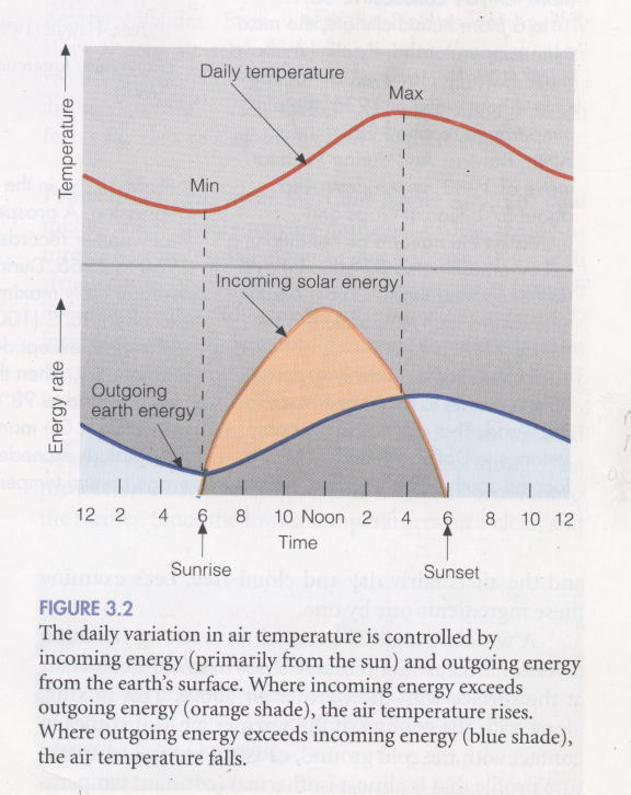
By the way, there is also a lag each day between the time of maximum solar heating (solar noon) and the time of the high temperature, which usually happens in the late afternoon (2:30-4:30 PM). Even though heating is maximum at noon, energy input from the sun remains greater than energy output (mainly in the form of radiation energy lost by the Earth) until late afternoon each day (see this figure showing typical daily temperature changes taken from Ahrens, Essentials of Meteorology, third edition).
Similar arguments can be applied to understand the lag between the day of minimum solar heating in the northern hemisphere (winter solstice around December 21) and the coldest time of the year in the northern hemisphere which occurs around the end of January. In this case, the energy output from the northern hemisphere is greater than the energy input from the sun until the end of January.
Thus the commonly used "summer season" contains the warmest time of the year in the northern hemisphere and the "winter season" contains the coldest time of the year in the northern hemisphere, even though they do not correspond with the astronomical terms "summer solstice" and "winter solstice" (see figure 17).
EXAMPLE: For Tucson, compare the differences in solar heating, average temperature, and trends in average temperature on the Spring Equinox (March 21) with the Fall Equinox (September 21).
ANSWER: The solar heating is the same on both dates. The solar declination is located at the equator on both dates, so the solar angle at noon in Tucson is 32° south of straight up. In addition, there are 12 hours of daylight on each date. The average temperature is much warmer on Sept 21 compared with Mar 21 because Sept 21 is much closer to the time of highest temperatures (end of July / beginning of August) than Mar 21. (For Tucson ave high is 74°F on Mar 21 and 93°F on Sept 21.) The trend on Mar 21 is for increasing temperatures as time moves forward (from the lowest temperature of the year (end of Jan) to the highest (end of July)). The trend on Sept 21 is for decreasing temperatures as time moves forward (from highest at end of July to lowest at end of January).
![]()
![]()
![]()
![]()