![]()
![]()
![]()
![]()
A region's climate is shaped by influences operating on all scales of space and time from microscale to global. Many factors work together to shape the climate of any locality.
This page lists and describes some of the factors that control or help determine the climate of a particular region. There are certainly others. Some of these factors can also be used to explain differences from one day to the next at one given location. For example, a humid, cloudy climate zone will generally have less variability in temperature during the year than a dry, sunny climate zone (the reasons are provided below). For the same reasons, a dry, cloud-free day will generally have a bigger difference between the nighttime low and daytime high temperature than a humid, cloudy day.
Latitude is the most important climatic control, due to the effect it has on the amount of solar radiation reaching the Earth's surface. The seasonal changes in incoming solar radiation, as well as the length of the day, vary with latitude. In general, tropical regions experience little seasonal changes in temperature since the amount of solar radiation received changes little during the year. Seasonal changes in temperature get more pronounced the further you move away from the tropics toward the polar regions. The largest seasonal changes are found in the Arctic and Antarctic regions because this is where there are the largest changes in the amount of solar radiation received during the year. If you consider the average temperature over one year, in general areas nearer to the equator are warmer than areas farther from the equator.
|
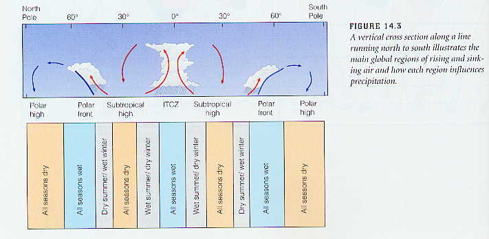
The figure above shows the general pattern of precipitation at different latitudes. This is related to where areas of rising and sinking motion are most likely based on the general circulation patterns around the globe. We have previously considered the ITCZ (Intertropical Convergence Zone) and subtropical high pressure areas when covering hurricanes. Recall that the polar front is the idealized boundary between warm and cold air masses and that its position at any given time can be estimated from the 500 mb trough/ridge height pattern. Keep in mind that the positions of the ITCZ (Intertropical Convergence Zone), subtropical highs, and the polar fronts move with the seasons. For example, in Northern Hemisphere Summer, the ITCZ moves north of the equator because the maximum solar heating moves north of the equator AND the positions of the subtropical high, and polar front moves north since the warm/cold boundary is further north. In the Northern Hemisphere winter these features move toward the south. Thus, since the favored regions for rising and sinking air move during the year, many places on Earth experience dry and wet seasons over the course of a year. This is quite pronounced for many tropical areas. Rainy seasons correspond with the times of the year when the ITCZ is located over an area, while dry seasons correspond with the times of year when the ITCZ is not located over an area.
Consideration of the movement of these features can help explain the seasonal changes observed in Tucson. During most of the year, the largest influence on our weather is the subtropical high, which results in sinking air and fair weather. In the wintertime, we are sometimes affected by the polar front, i.e., when troughs are able to dig as far south as Tucson, and this gives us some winter rains. In the summertime, the subtropical high moves to our north, which allows tropical air to move in, and gives us monsoon season rains. The ITCZ remains well south of Tucson, thus Tucson is on the northern edge of the tropical air, so our monsoon rains are spotty. Note that these generalizations concerning temperature and precipitation are due to changes of latitude alone, while the actual climate of a region also depends on some of the other factors listed below.
Elevation influences air temperature (since temperatures usually decrease with height by about 6.5°C per 1000 meters or 3.6°F per 1000 ft). Therefore, higher elevation locations are generally colder than lower elevation locations throughout the year, assuming that latitude and other climate control factors are the same. Elevation can also influence whether precipitation falls in the form of rain or snow. A local example is provided by the differences in temperature and precipitation between Tucson and Mount Lemon. Often in the winter precipitation in the valley is in the form of rain, while over the mountains it is in the form of snow. Generally speaking, higher elevation regions get more precipitation than nearby lower elevation regions since the mountain slopes force air to rise, which favors the formation of clouds and precipitation. Thus, higher elevation sites are generally cooler and wetter (experience more precipitation) than nearby lower elevation sites.
Another difference between high altitude locations (mountains) and low altitude locations (sea level) is that the daily temperature extremes between day and night are typically greater at higher elevations. This is mainly because there is so much less atmosphere above high elevation locations (i.e., less air molecules). During the day, less atmosphere means that it is easier for the Sun's energy to reach the surface and heat it. At night, less atmosphere means fewer greenhouse gases and a weaker greenhouse effect, so the ground surface cools more rapidly.
A location's proximity to Mountain Ranges relative to the prevailing air flow can be an important factor. Mountain ranges can affect the climate for considerable distances by stimulating cyclone formation. Another way to state this is that large mountain ranges in the middle latitudes have some influence on the large-scale weather pattern, i.e., the trough/ridge pattern on 500 mb maps.
|
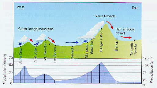
| The effect of topography on average annual precipitation along a line running through California from the Pacific Ocean into western Nevada. (Figure taken from Ahrens, Essentials of Meteorology, 2nd Edition, Copyright © 1994 by West Publishing Co.) |
Locally, orographic clouds and precipitation form on windward facing slopes, while a rain shadow is often found on the leeward slopes. An example of the effect of topography on precipitation is shown in the figure above. The figure shows an east to west transect across the state across the state of California from the Pacific coast on the left to Great Basin area of Nevada on the right. The prevailing wind flow during the winter months is westerly, i.e., from the Pacific coast toward the Great Basin. Where the mountains force the prevailing flow upward, clouds and precipitation occur, while where mountains force the prevailing flow downward, skies are clear with little precipitation.
| Substance | Specific Heat |
|---|---|
| Water | 1.00 |
| Air | 0.24 |
| Granite | 0.19 |
| Sand | 0.19 |
| Iron | 0.11 |
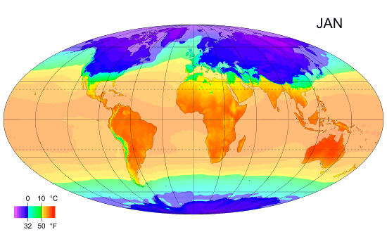
Therefore, over the course of a typical day (daily cycle), the land heats more rapidly and to a higher surface temperature than surrounding water during the daytime, and it cools more rapidly and to a lower surface temperature than surrounding water during the nighttime. Over yearly time scales, ocean temperatures are slow to change with the seasons. Compared to the continental land areas, ocean surface temperatures change little between summer and winter (see the animation below). Notice in the animation that during the winter months, the continental interiors are colder than the surrounding ocean (at the same latitude), while during the summer months, the continential interiors are warmer than the surrounding ocean. The closer a land area is to the ocean, the more it is influenced by the ocean, and the more moderate the climate. On even longer timescales, such as those considered in global warming studies, the oceans can slow down the rate of warming that may come about due to increases in greenhouse gases.
|
| Animated map of monthly mean surface air temperature |
The circulation of the ocean is a another key factor in air temperature distribution.
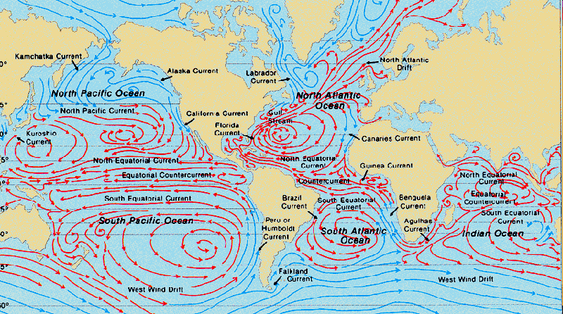
Ocean currents that have a northward or southward component, such as the warm Gulf Stream in the North Atlantic or the cold Humboldt Current off South America, effectively exchange heat between low and high latitudes. Recall the influence that these ocean currents have on US climates. The southeastern US experiences many thunderstorm days per year due to the destabalizing influence of the warm surface waters of the Gulf of Mexico and Atlantic Gulf Stream, while the west coast experiences few thunderstorms due to the stabalizing influence of the cold Pacific surface waters associated with the California Current.
|
| The circulation of the ocean. |
A good example of the effect of a warm current is that of the Gulf Stream in January, which causes a strong east-west gradient in temperatures across the eastern edge of the North American continent. The relative warmth of the Gulf Stream affects air temperatures all the way across the Atlantic, and prevailing westerlies extend the warming effect deep into northern Europe. As a result, January temperatures of Tromsø, Norway (69°40'N), for example, average 24°C above the mean for that latitude.
|
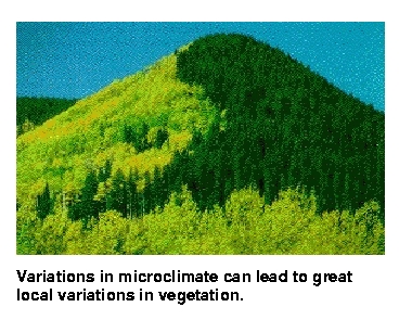
| Notice the vegetation patterns on the mountain pictured above. |
The most important influence of water vapor in the atmosphere on surface temperature happens at night. At night, places with higher amounts of water vapor in the atmosphere tend to stay warmer because water vapor is a greenhouse gas. During the day, water vapor absorbs some of the radiation energy from the sun keeping the ground surface cooler. High relative humidity also causes aerosol particles to swell so that they absorb and reflect more radiation from the sun before it reaches the ground. Therefore, dry desert regions like Tucson tend to have relatively large temperature swings between day and night compared with a location that has more water vapor and higher relative humidity.
Variations in the slope of the ground affects the absorbed sunlight, exposure to winds, and runoff. An example of this effect is shown in the figure on the right where different types of vegetation are favored on the opposing slopes of a mountain. For mountains in the middle latitudes of the Northern Hemisphere, southward facing slopes face toward the midday sun, which results in more direct sunshine received and more heating, compared with northward facing slopes, which face away from the midday sun and remain cooler. In the moutains around Tucson, saguaro cacti are most dense on south facing slopes and can be found at higher altitudes on south facing slopes compared with north facing slopes.
Many of the above factors influence the amount and type of cloud cover experienced by a local region. In general, clouds are a cooling influence during the day by reflecting solar radiation, and a warming influence at night because they emit infrared radiation (same principle as greenhouse effect for gases). Thus, locations with high amounts of cloud cover tend to experience less temperature variation over a day (cooler days, warmer nights) compared with a location with clear conditions.
Local surface conditions might shape climate to a considerable extent. Consider the where would you choose to sit (or even stand) on a sunny day in July... Have you noticed differences in temperature as you drive out of Tucson city limits on a summer evening? Some examples:
Agriculture and other human induced changes in the amount and type of vegetation will have variable effects on local climate. For example, in places where forests are replaced with crops, less vegetation cover means the surface has less moisture available for evaporation. As a result, it experiences higher temperatures than a forested region. However, the opposite effect will be experienced when dry lands are converted to irrigated fields. Another factor is that urban areas become "heat islands", i.e., warmer than the surrounding countryside for two main reasons: (1) The asphalt, bricks, roofing materials, etc. of which modern cities are constructed better absorb solar radiation than soils and vegetation; and (2) Human activities (power generation, transportation, etc.) generate heat, which warms cities.
There are various ways to categorize the diverse climate zones around the world. The link below is just one example. Unfortunately, we don't have time to cover this topic in detail. The Koppen Climate Zones
![]()
![]()
![]()
![]()