![]()
![]()
![]()
![]()
![[thunderstorm cloud]](thunderstorm_noaa.jpg)
|
| Mature thunderstorm with typical anvil shaped cloud. |
Thunderstorms are violent weather systems. Fortunately, most thunderstorms are spatially small and temporally short-lived. Only a small fraction of all thunderstorms are classified as severe thunderstorms.
Thunderstorms form when moist, unstable air is lifted vertically into the atmosphere. The processes that initiate the vertical lifting were previously discussed. These are unequal heating of the Earth's surface (surface heating and free convection), orographic (mountain) lifting, dynamical lifting, which occurs near areas of lower level convergence and/or upper level divergence, and lifting because of the presence of a frontal zone -- each of these can initiate thunderstorm development. You may want to review the Conditions which force air to rise as each of these can initiate thunderstorm development.
Immediately after lifting begins, a rising parcel of warm moist air begins to expand and cool. At a certain elevation the parcel will reach saturation with respect to water vapor resulting in condensation and the formation of a cumulus cloud. During condensation, large quantities of latent heat are released. Much of the energy used in thunderstorm development comes from the release of latent heat. It is the heat released by condensation within a cloud that permits the rising air to stay warmer than its surroundings, and thus to be buoyant through great depths.
With the vertical extension of air parcels, the cumulus cloud grows into a cumulonimbus cloud. Cumulonimbus clouds can reach heights of 20 kilometers above the Earth's surface. Severe weather associated with thunderstorms includes hail, strong winds, lightning, intense rain, flash flooding, and tornadoes.
Thunderstorm development requires an unstable atmosphere. The more unstable the atmosphere, the more violent the potential thunderstorm. There are three basic ways to make the atmosphere more unstable:
It is estimated that more than 40,000 thunderstorms occur each day throughout the world. Annually, this adds up to 14,500,000 thunderstorms per year.
![[Worldwide lightning flashes from satellites]](lightningmap_world.gif)
|
| Distribution of world-wide lightning strikes from satellite-based optical sensors. Units are #flashes per square kilometer per year. Figure provided by NSSTC lightning team. |
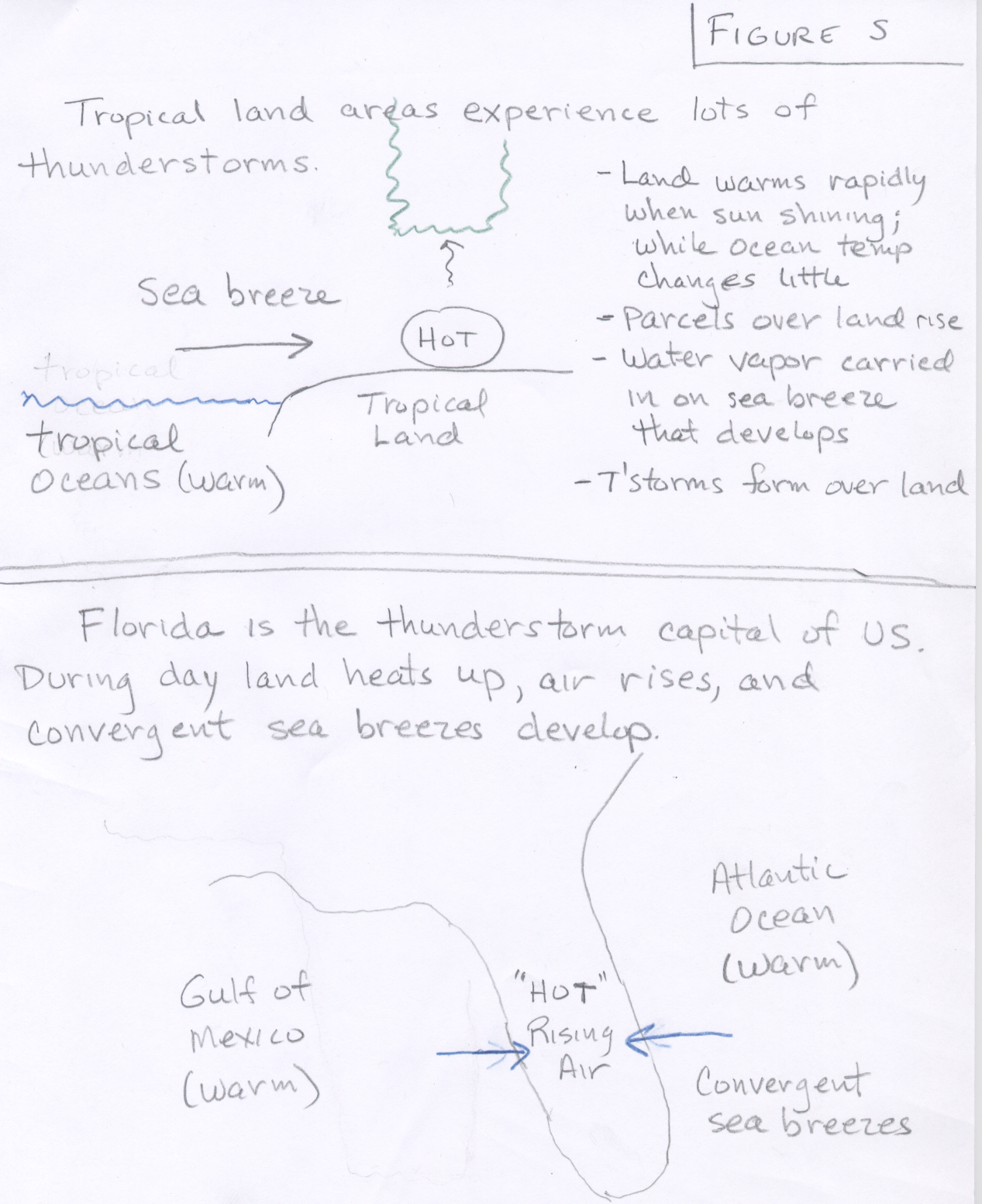
Thunderstorms form from the equator to as far north as Alaska. They occur most commonly in the tropics where the intense sunshine strongly heats the moist surface air all year round. Many tropical land based locations experience over 100 thunderstorm days per year (see Figure S (top)). Thunderstorm formation over tropical oceans is less frequent because ocean surfaces do not warm as rapidly as land surfaces. Thus, in general, thunderstorms are much more common over land areas than over the oceans. Outside the tropics, thunderstorm formation is more seasonal occurring most often in those months where heating from the sun is most intense. While tropical areas do produce the most thunderstorms per year, the most common place for severe thunderstorms is in the middle latitude regions of the Earth. In these regions, warm moist tropical air can mix with cold polar air, which sets the stage for severe thunderstorms.
The figure bellow shows the average number of days each year having thunderstorms in various parts of the United States. Note that this figure includes all thunderstorms. Most thunderstorms are not severe thunderstorms.
![[thunderstorm frequency - US]](TstormFreq.gif)
|
| The average number of days each year on which thunderstorms are observed thoughout the United States. (Due to the scarcity of data, the number of thunderstorms is underestimated in the mountainous west.) |
The figure above describes the annual average number of thunderstorm days across the United States. You should be familar with the thunderstorm characteristics of three distinct regions, labeled (1) - (3) in the text. (1) According to this map, the greatest incidence of thunderstorms occurs in the southeastern United States. This particular spatial distribution suggests that extreme solar heating is not the only requirement for thunderstorm formation. Another important prerequisite is the availability of large quantities of water vapor at the surface. The southeastern states are surrounded by the warm ocean waters of the Gulf of Mexico and the warm Gulf Stream Current along the east coast, which supplies vast quantities of water vapor for the adjacent land areas. The atmosphere is often relatively unstable, particularly during the day when the ground is warmed by the sun, quickly forming cumulonimbus clouds when surface heating is intense. Florida is the thunderstorm capital of the United States as it is surrounded on three sides by warm ocean water (see Figure S (bottom)). (2) A secondary maximum in thunderstorm days is found in Colorado, Arizona, and New Mexico. In this region the mountainous terrain is an important factor. Mountain slopes that face the sun absorb more direct solar radiation and become relatively warmer creating strong updrafts that form into cumulus clouds. These areas are much less humid than the southeastern United States, thus the thunderstorms in these areas are characterized by higher cloud bases and less rainfall. During the summer monsoon season, east winds bring some tropical moisture resulting in a strong seasonal increase in thunderstorm frequency. (3) Few thunderstorms occur along the west coast of the United States. The main reason is that this region is adjacent to the cold surface ocean water of the eastern Pacific Ocean. The cold air in the lower atmosphere makes the atmosphere stable and not conducive to thunderstorm formation. In other words, the atmosphere along the west coast of the United States is typically stable because surface air usually comes from the relatively cold eastern Pacific Ocean.
![]()
![]()
![]()
![]()