![]()
![]()
![]()
![]()
Most clouds form as air rises and cools. There are several mechanisms that force surface air to rise. We briefly looked at the most common and important mechanisms that force air to rise. At the moment lets assume that we are in a region of the atmosphere where the surface air is being forced to rise upward. This page explains the concept of atmospheric stability and how it influences the size and shapes of clouds. An important reason for discussing atmospheric stability is that thunderstorms, tornadoes, and hurricanes form when the atmosphere is unstable. The more unstable the atmosphere, the higher the potential for severe weather. There are two general types of clouds:
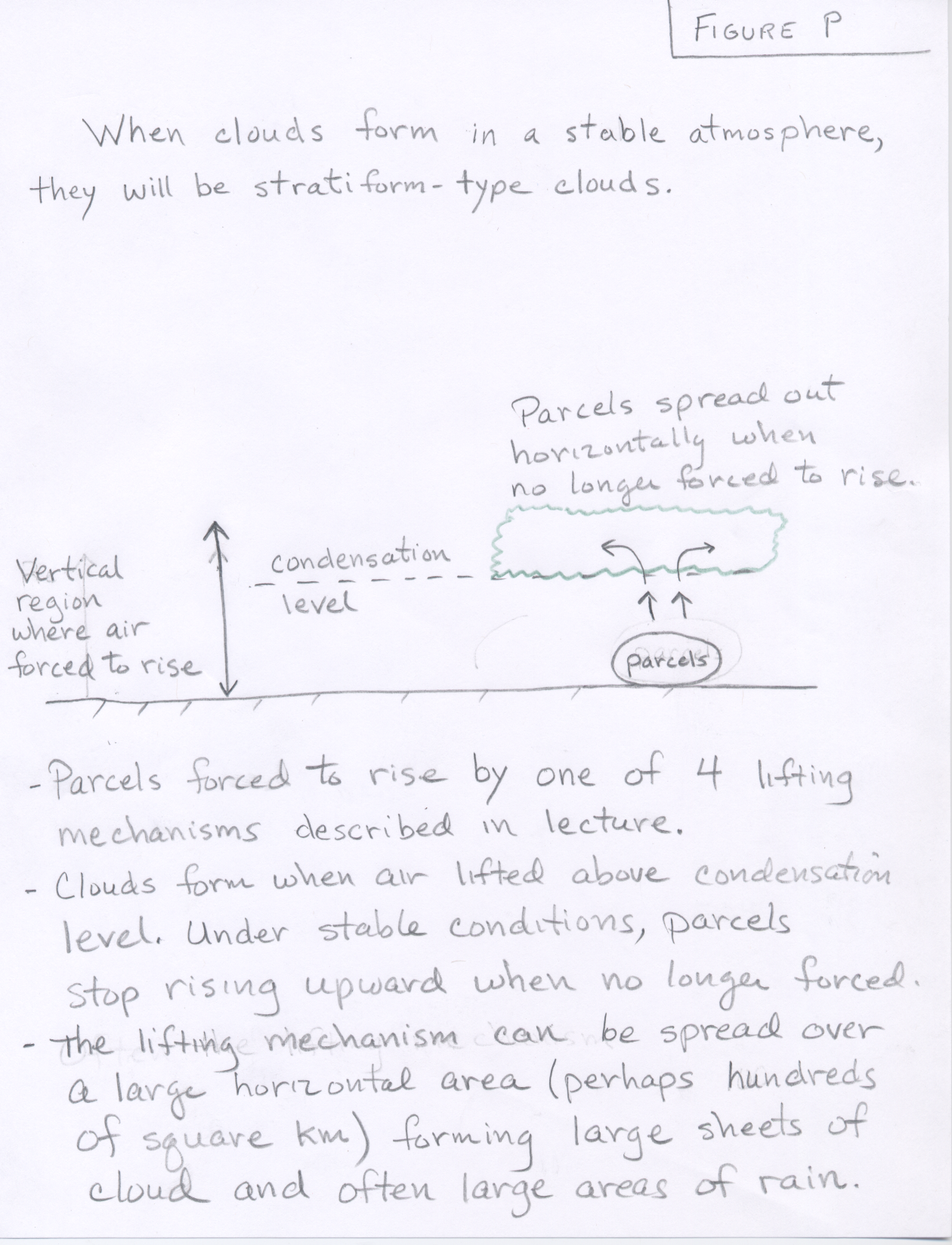
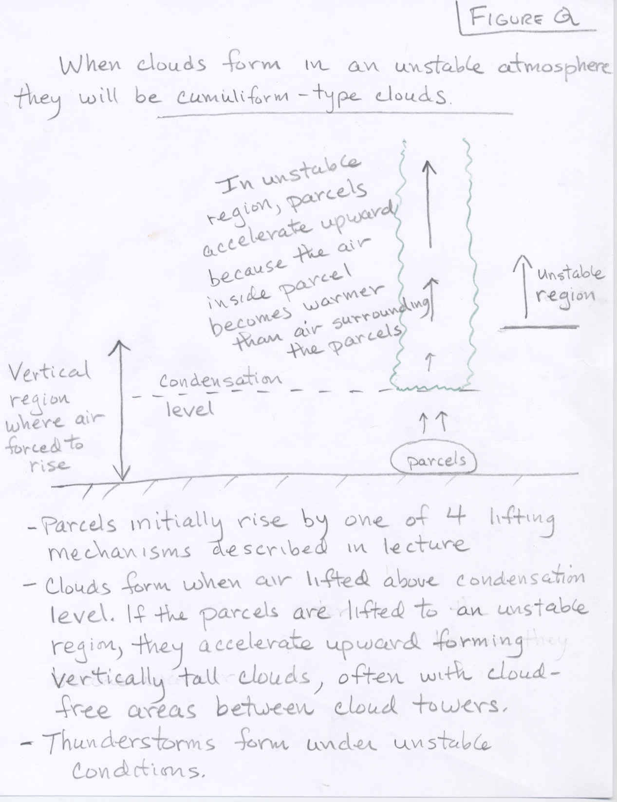
These drawings of stratiform-type and cumuliform-type clouds should help you to understand the differences between these general cloud types.
Although we are going to spend most of this class talking about the weather that occurs under unstable atmospheric conditions, you should realize that most of the time the atmosphere is not unstable. A good portion of the clouds and precipitation that form on Earth happen when the atmosphere is stable, including many episodes of heavy rain and flooding. We are focusing on unstable conditions since much of the more interesting severe weather, like thunderstorms, tornadoes, lightning, and hurricanes, only happens when the atmosphere is unstable. Please understand that the atmosphere does not need to be unstable for clouds and precipitation to occur and most often the atmosphere is stable. Clouds and precipitation commonly form under stable atmospheric conditions where air is forced upward.
If the temperature of the air in a parcel becomes warmer than the surrounding envrionmental air, the air parcel becomes buoyant, and accelerates upward. Again, the surrounding environmental air refers to the air surrounding the parcel, which is at the same pressure and altitude as the parcel. In other words, a warm parcel is less dense than the cooler air surrounding it, so the parcel gets forced upward by the more dense surrounding fluid. When rising air parcels become warmer than the surround air, we say the atmosphere is unstable. Thus, the atmosphere is said to be unstable if the temperature of a lifted parcel becomes warmer than the surrounding air.
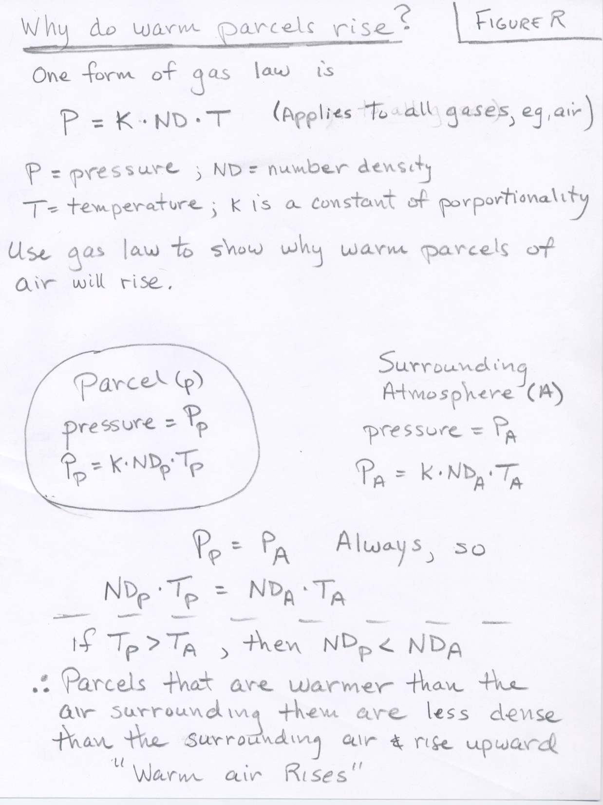
This is similar to what happens if you place a block of wood at the bottom of a pool of water and let it go. The block will be forced upward because it is less dense than the surrounding fluid. Parcels which are warmer than the environmental air surrounding them are less dense than the surrounding fluid and are forced to rise upward. We can use the kinetic model of gases to explain why warm parcels are less dense than the cooler air surrounding them. Rememeber gas pressure is caused by collisions of countless numbers of gas molecules on a surface. Consider a parcel of air that is originally at the same temperature and pressure of the air surrounding the parcel. Now heat the air in the parcel. This will temporarily increase the air pressure inside the parcel becuase the gas molecules begin moving faster and thus collide more forcefully with the sides of the parcel. Since the air pressure inside the parcel must always come into balance with the pressure of the air surrounding the parcel, the parcel expands. Now we have the same number of gas molecules in a larger volume, thus the number density of air in the parcel has lowered. This makes the warmer parcel less dense (lighter) than the surrounding air, so it is forced to rise up in the same way that a block of wood rises up when surrounded by a water (a more dense fluid).
This can also be easily shown using the gas law. Recall that parcels in the atmosphere adjust their size so that the air pressure inside the parcel equals the air pressure outside the parcel (This is always the case). If the air temperature inside a parcel is warmer than the air temperature of the air surrounding the parcel, the number density inside the parcel is lower than the number density outside the parcel. Thus, the air parcel weighs less than an equal volume of air outside the parcel and it will rise upward (see Figure R).
In the atmosphere, beside the mechanism of surface heating and free convection, the only other way in which parcels become unstable is when the latent heat released during cloud formation (water vapor condensing to liquid cloud droplets) is enough to make the temperature of the parcel warmer than the surrounding environmental air. Meteorologists assess and compute the stability of the atmosphere by lifting hypothetical parcels of air upward from the surface and comparing the parcel temperature with the temperature of the surrounding air. The temperature of the surrounding air from ground level upward is measured twice each day by releasing weather balloons with instruments attached. If the atmosphere is found to be unstable for lifted parcels, there is the possibility of thunderstorms; however, if the atmosphere is found to be stable for lifted parcels, thunderstorms will not form.
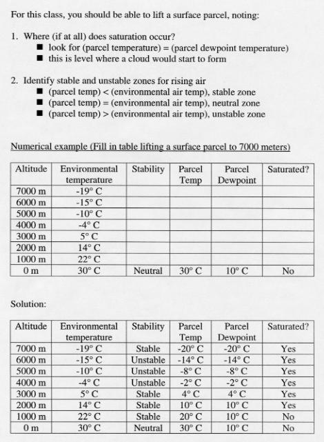
In this class, we will illustrate the concepts of cloud formation and stability using simplified numerical examples. The basic problem will be given the vertical temperature structure of the atmosphere and the water vapor content of air at the surface, lift a hypothetical parcel upward to determine (a) at what altitude will a cloud start to form and (b) at what altitude, if at all, will the parcel become unstable.
Recall the rules we already discussed for lifting air parcels:
Now we add the concept of stability. To determine stability, compare the parcel temperature with the temperature of the surrounding air and think about what would happen if the parcel was "let go" or no longer forced upward.
An example of a "blank" table is given below. You are expected to use the rules for moving air parcels to keep track of the temperature and dew point temperature (water vapor content) in an air parcel that is moved upward from 0 meters to 8000 meters above sea level. The designation "neutral" is used to indicate that the parcel temperature is the same as the air temperature of the surrounding atmosphere and thus the parcel is the same density as the surrounding atmosphere.
|
Altitude (meters above Sea level) |
Environmental Temperature (°C) |
Stability? |
Parcel Temperature (°C) |
Parcel Dew Point Temperature (°C) |
|
8000 |
-15 |
|
|
|
|
7000 |
-12 |
|
|
|
|
6000 |
-9 |
|
|
|
|
5000 |
-2 |
|
|
|
|
4000 |
5 |
|
|
|
|
3000 |
12 |
|
|
|
|
2000 |
20 |
|
|
|
|
1000 |
28 |
|
|
|
|
0 |
35 |
Neutral |
35 |
25 |
The rules for keeping track of the temperature and dew point temperature were given on the previous page. Now we add the concept of stability. We are specifically checking to see if a rising parcel becomes warmer than the surrounding environmental air. The next table has been filled in up to the lowest altitude where the air parcel becomes unstable.
|
Altitude (meters above Sea level) |
Environmental Temperature (°C) |
Stability? |
Parcel Temperature (°C) |
Parcel Dew Point Temperature (°C) |
|
8000 |
-15 |
|
|
|
|
7000 |
-12 |
|
|
|
|
6000 |
-9 |
|
|
|
|
5000 |
-2 |
|
|
|
|
4000 |
6 |
Unstable |
7 |
7 |
|
3000 |
14 |
Stable |
13 |
13 |
|
2000 |
21 |
Stable |
19 |
19 |
|
1000 |
28 |
Stable |
25 |
25 |
|
0 |
35 |
Neutral |
35 |
25 |
You should realize that the rising parcel reaches saturation (its temperature cooled to equal its dew point temperature) at an altitude of 1000 meters. This is the level where a cloud would start to form in the parcel. You should realize that once condensation begins and a cloud starts to form, the rate of cooling changes from 10°C per 1000 meters to 6°C per 1000 meters to account for the latent heat realeased by the condensation of cloud formation. At an altitude of 4000 meters, the temperature of the air in the lifted parcel is warmer than the temperature of the air surrounding the parcel, which is specified in the column "Environmental Temperature." This is the unstable situation for a parcel moving upward. For the atmospheric coniditions specified in the table, if an air parcel were forced upward to 4000 meters, it would become unstable, i.e., warmer and less dense than the surrounding air. An unstable parcel will accelerate upward as long as it remains warmer and less dense than the surrounding air. The remainder of the table is filled in below.
|
Altitude (meters above Sea level) |
Environmental Temperature (°C) |
Stability? |
Parcel Temperature (°C) |
Parcel Dew Point Temperature (°C) |
|
8000 |
-15 |
Stable |
-17 |
-17 |
|
7000 |
-12 |
Unstable |
-11 |
-11 |
|
6000 |
-9 |
Unstable |
-5 |
-5 |
|
5000 |
-2 |
Unstable |
1 |
1 |
|
4000 |
6 |
Unstable |
7 |
7 |
|
3000 |
14 |
Stable |
13 |
13 |
|
2000 |
21 |
Stable |
19 |
19 |
|
1000 |
28 |
Stable |
25 |
25 |
|
0 |
35 |
Neutral |
35 |
25 |
Note that the parcel was unstable over the altitude range from 4000 to 7000 meters above sea level and then it became stable again. If an air parcel were forced up to 4000 meters, it would then accelerate upward from 4000 to 7000 meters over the altitude range where it is warmer than the surrounding air, and stop accelerating upward by 8000 meters when the parcel becomes colder and more dense than the surrounding air.
Here is another numerical example. The first table shows you what you would know about the atmosphere before performing the stability analysis. You would have to fill in the blanks. The second table shows the solution. You will be asked to perform similar problems in homework. Click Here to view the example.
When the atmospheric is unstable, time-lapse videos of developing clouds can be quite interesting. The videos placed under the link below are quite large (file size), and if you cannot view them that is ok. I suggest looking at the one dated 20070823 as a good example of a day when it was unstable and storms formed. Once parcels are pushed up to the level where they become unstable, they accelerate upward, trailing towers of cumulus clouds.
(Cloud annimation videos taken from the roof of the PAS building at the University of Arizona
Meteorologists use a similar method to assess the potential for thunderstorms and severe weather:
If analysis shows that the atmosphere is unstable, it means that there is the potential for thunderstorms to form, however, it does not guarantee that thunderstorms will form. An unstable atmosphere means that there is potential energy available for thunderstorms to develop, but this potential energy will not be realized unless air parcels are lifted up to the altitude where they become unstable. When thunderstorms do form, this potential energy is converted to kinetic energy. This is why some meteorologist say that a lifting mechanism is required to "release the instabily" or unleash the potential energy available under the given atmospheric conditions.
![]()
![]()
![]()
![]()