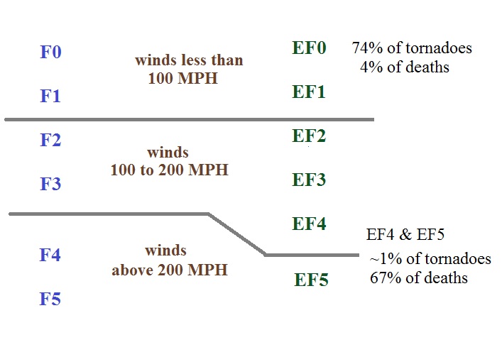
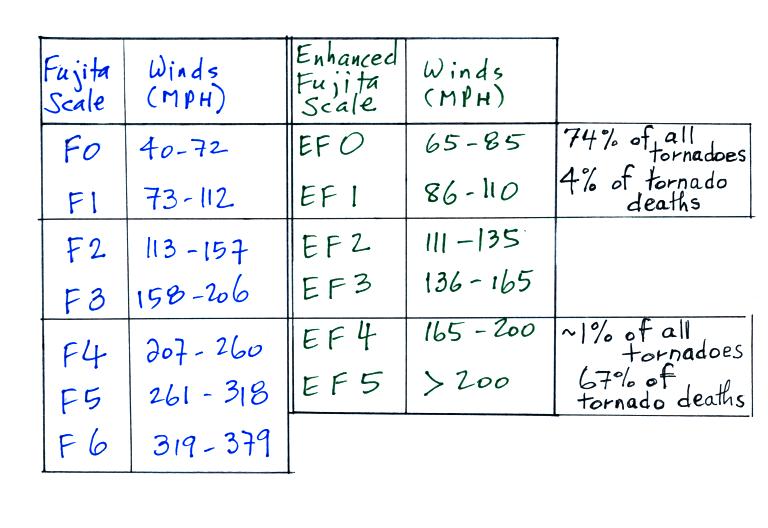
Here is a comparison of the
actual scales
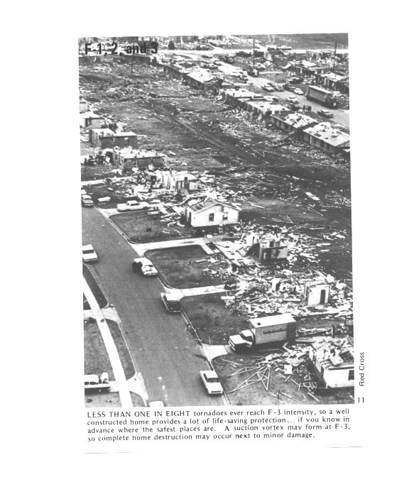
There's also a much more detailed set of guidelines for determining the EF scale rating from a survey of tornado. Different objects and structures react differently when subjected to tornado (or microburst) strength winds.
The EF scale has 28 "damage indicators" that can be examined to determine tornado intensity. You can think of these as being different types of structures or object that could be damaged by lightning.. Examples include:
| Damage
Indicator |
Description |
| 2 |
1 or 2 family
residential home |
| 3 |
Mobile home (single
wide) |
| 10 |
Strip mall |
| 13
|
Automobile showroom |
| 22
|
Service station
canopy |
| 26 |
Free standing light
pole |
| 27 |
Tree (softwood) |
Then for each indicator is a standardized list of "degrees of damage" that an investigator can look at to estimate the intensity of the tornado. For a 1 or 2 family home for example
| degree of damage |
description |
approximate wind speed (MPH) |
| 1 |
visible
damage |
65 |
| 2 |
loss
of roof covering material |
80 |
| 3 |
broken
glass in doors & windows |
95 |
| 4 |
lifting
of roof deck, loss of more than 20% of roof material,
collapse of chimney, garage doors collapse inward,
destruction of porch roof or carport |
100 |
| 5 |
house
slides off foundation |
120 |
| 6 |
large
sections of roof removed, most walls still standing |
120 |
| 7 |
exterior
walls collapse (top story) |
130 |
| 8 |
most
interior walls collapse (top story) |
150 |
| 9 |
most
walls in bottom floor collapse except small interior
rooms |
150 |
| 10 |
total
destruction of entire building |
170 |
You'll find the entire set of damage indicators and lists of degrees of damage here.
Here's some recent video of damage being caused by a tornado as it happened (caught on surveillance video). The tornado struck West Liberty, Kentucky on March 2, 2012.
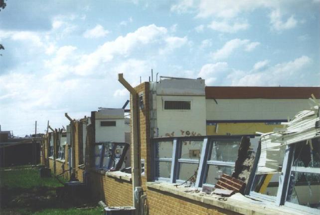
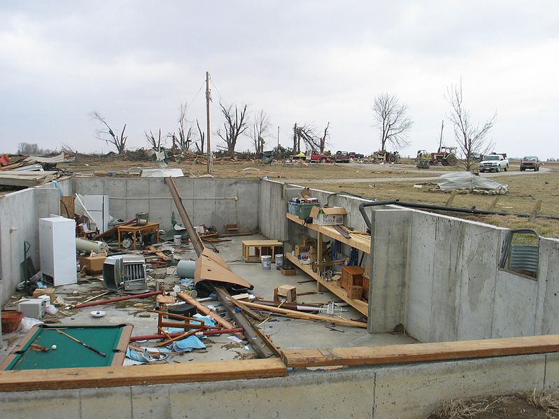
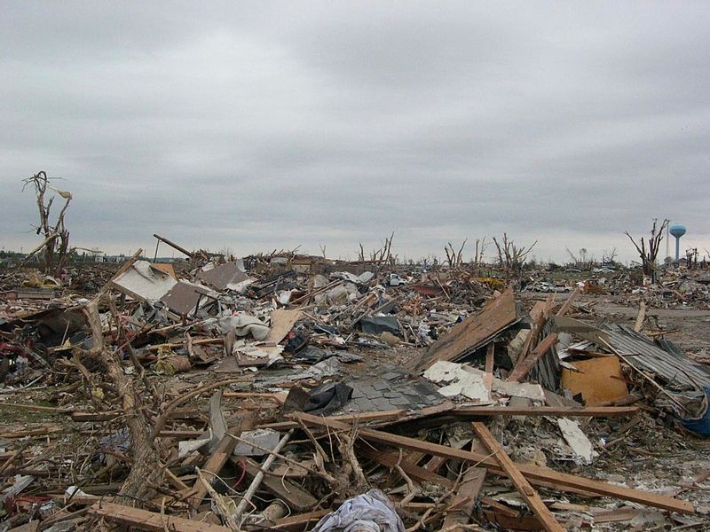
Here are photographs of some actual tornado damage and the EF Scale rating that was assigned to each
| EF2
Damage roof is gone, but all walls still standing |
EF4
Damage only the strong reinforced concrete basement walls (part of the wall was below ground) are left standing. It doesn't look like there would have been anywhere in this building that would have provided protection from a tornado this strong. |
EF5
Damage complete destruction of the structure |
 |
 |
 |
At this point we watched the last of the tornado video tapes. It showed a tornado that occurred in Pampa, Texas (here are a couple of videos that I found on YouTube: video 1, video 2, they're missing the commentary that was on the video shown in class). Near the end of the segment, video photography showed several vehicles (pick up trucks and a van) that had been lifted 100 feet or so off the ground and were being thrown around at 80 or 90 MPH by the tornado winds. Winds speeds of about 250 MPH were estimated from the video photography (though the wind speeds were measured above the ground and might not have extended all the way to the ground).
Multiple vortex tornadoes
And finally, something that was initially something of a puzzle to tornado researchers.
Several levels of damage (EF1 to about EF3) are visible in the photograph above. It was puzzling initially how some homes could be nearly destroyed while a home nearby or in between was left with only light damage. One possible explanation is shown below.
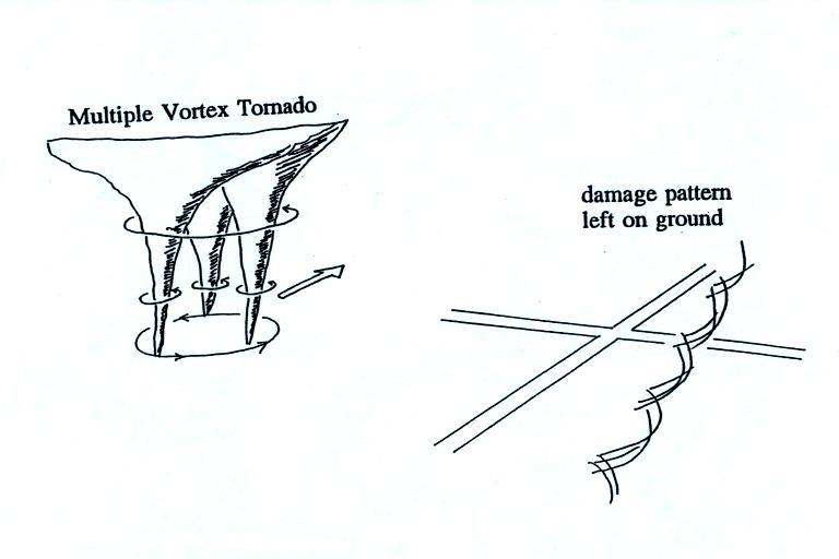
Some big strong tornadoes may have smaller more intense "suction vortices" that spin around the center of the tornado (they would be hard to see because of all the dust in the tornado cloud. Tornado researchers have actually seen the damage pattern shown above scratched into the ground by the multiple vortices in a strong tornado.
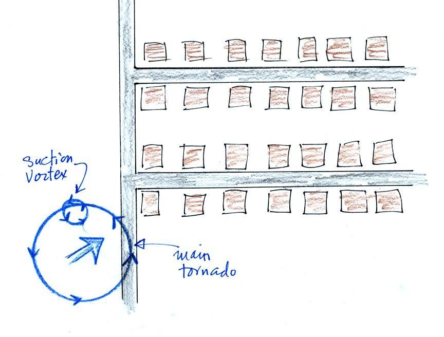
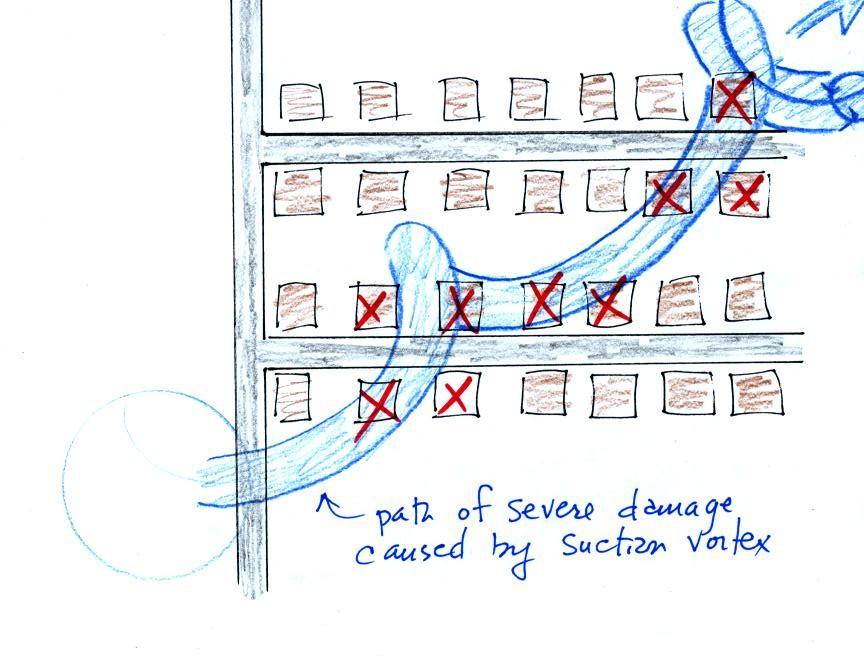
The homes marked in red would be damaged severely. The others would receive less damage. Just one suction vortex was used here, there are usually several. But the tornado diameter is probably larger than shown here.
Lightning
Lightning kills just under 100 people every year in the United States (more than tornadoes or hurricanes but less than flooding, summer heat and winter cold) and is the cause of about 30% of all power outages.
In the western United States, lightning starts about half of all forest fires. Lightning caused fires are a particular problem at the beginning of the thunderstorm season in Arizona. At this time the air underneath thunderstorms is still relatively dry. Rain falling from a thunderstorm will often evaporate before reaching the ground (virga). Lightning then strikes dry ground, starts a fire, and there isn't any rain to put out or at least slow the spread of the fire. This is so called dry lightning. Strong downdraft winds from the thunderstorm can help the fire grow and spread.
We'll be concerned with the lightning produced by thunderstorms but it has also be observed in dust storms and volcanic eruptions such as in these other worldly pictures of the 2010 eruption of Eyjafjallajokull in Iceland. And the pictures from the Calbuco volcano in Chile.
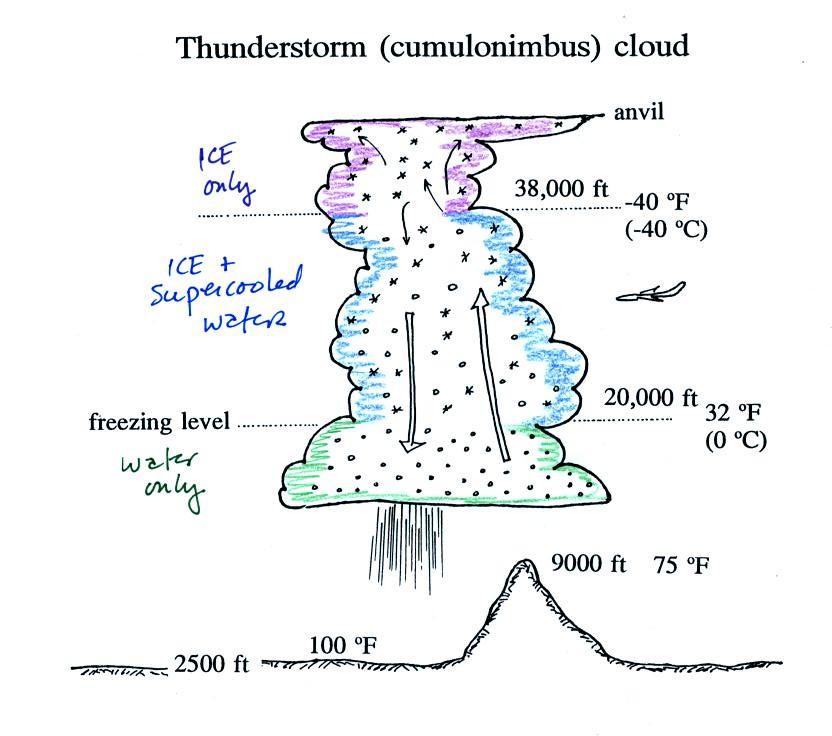
A typical summer
thunderstorm in Tucson is shown in the figure above
(p. 165 in the photocopied ClassNotes). Even on
the hottest day in Tucson in the summer a large part
of the middle of the cloud is found at below freezing
temperatures and contains a mixture of super cooled
water droplets and ice crystals. This is where
precipitation forms and is also where electrical
charge is created. Doesn't it seem a little
unusual that electricity, static electricity, can be
created in the wet interior of a thunderstorm?
1. What produces the electrical charge needed for lightning?
2. Different types of lightning
1. What produces the electrical charge needed for lightning?
2. Different types of lightning
Collisions between precipitation
particles produce the electrical charge needed for
lightning. When temperatures are
colder than -15 C (above the dotted line in the figure
above), graupel becomes negatively charged after
colliding with a snow crystal. The snow crystal
is positively charged and, because it is smaller and
lighter, is carried up toward the top of the cloud by
the updraft winds. At temperature warmer than
-15 (but still below freezing), the polarities are
reversed. A large volume of positive charge
builds up in the top of the thunderstorm. A
layer of negative charge accumulates in the middle of
the cloud. Some smaller volumes of positive
charge are found below the layer of negative
charge. Positive charge also builds up in the
ground under the thunderstorm (it is drawn there by
the large layer of negative charge in the cloud).
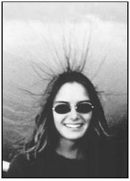
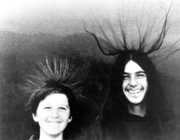
A couple of interesting things can happen at the ground under a thunderstorm. Attraction between positive charge in the ground and the layer of negative charge in the cloud can become strong enough that a person's hair will literally stand on end (see two photos below). This is incidentally a very dangerous situation to be in; I wouldn't wait around for my picture to be taken.
St. Elmo's Fire (corona discharge) is a faint electrical discharge that sometimes develops at the tops of elevated objects during thunderstorms. The link will take you to a site that shows corona discharge. Have a look at the first 3 pictures, they probably resemble St. Elmo's fire. The remaining pictures are probably different phenomena. St. Elmo's fire was first observed coming from the tall masts of sailing ships at sea (St. Elmo is the patron saint of sailors). Sailors in those days were often very superstitious and I suspect they found St. Elmo's fire terrifying.
A couple of interesting things can happen at the ground under a thunderstorm. Attraction between positive charge in the ground and the layer of negative charge in the cloud can become strong enough that a person's hair will literally stand on end (see two photos below). This is incidentally a very dangerous situation to be in; I wouldn't wait around for my picture to be taken.
 |
 |
St. Elmo's Fire (corona discharge) is a faint electrical discharge that sometimes develops at the tops of elevated objects during thunderstorms. The link will take you to a site that shows corona discharge. Have a look at the first 3 pictures, they probably resemble St. Elmo's fire. The remaining pictures are probably different phenomena. St. Elmo's fire was first observed coming from the tall masts of sailing ships at sea (St. Elmo is the patron saint of sailors). Sailors in those days were often very superstitious and I suspect they found St. Elmo's fire terrifying.
Air is normally an insulator, but
when the electrical attractive forces between the
volumes of charge in the cloud gets gets high enough
lightning occurs. Most lightning (2/3 rds, maybe
even 3/4) stays inside the cloud and travels between the
main positive charge center near the top of the cloud
and the layer of negative charge in the middle of the
cloud; this is intracloud lightning (Pt. 1). About
1/3 rd of all lightning flashes strike the ground.
These are called cloud-to-ground discharges (actually
negative cloud-to-ground lightning). We'll spend
most of the class learning about this particular type of
lightning (Pt. 2). It's what kills
people and starts forest fires.
Positive polarity cloud to ground lightning (Pt. 3) accounts for a few percent of lightning discharges. Upward lightning is the rarest form of lightning (Pt. 4). We'll look at both of these unusual types of lightning later in the class.
Positive polarity cloud to ground lightning (Pt. 3) accounts for a few percent of lightning discharges. Upward lightning is the rarest form of lightning (Pt. 4). We'll look at both of these unusual types of lightning later in the class.
A cloud to ground lightning flash is actually a sequence of several separate events.
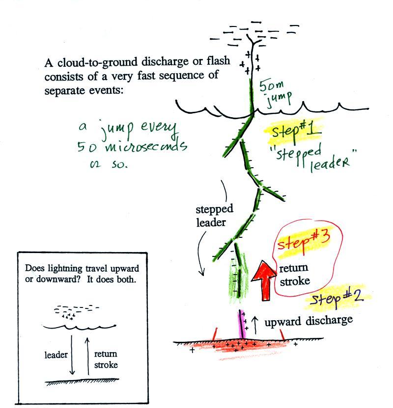
Most cloud to ground discharges begin with a negatively-charged downward-moving stepped leader (the figure above is on p. 166 in the ClassNotes). A developing channel makes its way down toward the cloud in 50 m jumps that occur every 50 millionths of a second or so. Every jump produces a short flash of light (think of a strobe light dropped from an airplane that flashes on and off as it falls toward the ground). The sketch below shows what you'd see if you were able to photograph the stepped leader on moving film. Every 50 microseconds or so you'd get a new picture of a slightly longer channel displaced slightly on the film (the flash of light would come from the highlighted segments would be captured on film).
Here's an actual slow motion
movie (video not film) of a stepped leader.
The video camera used here was able to collect
7207 images per second ( a normal video camera takes 30
images per second). The images were then replayed at
a slower rate. 1/8 of a second of lightning is
stretched out to about 30 seconds on the video.
As the leader channel
approaches the ground strong electrical attraction
develops between negative charge in the leader channel and
positive charge on the surface of the ground.
Several positively charged sparks develop and move
upward toward the stepped leader. One of these will
intercept the stepped leader and close the connection
between negative charge in the cloud and positive charge
on the ground.
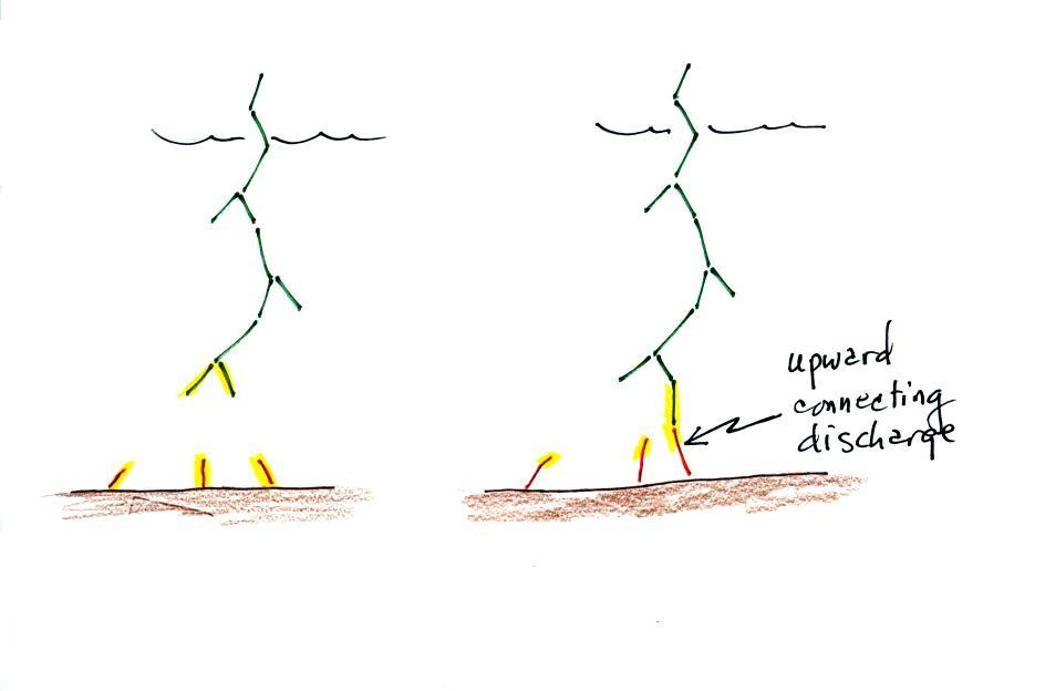
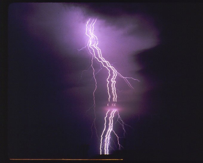
You can see the actual photograph on the photographers homepage. There were at least 3 upward discharges initiated by the approach of the stepped leader (1, 2, and 3 in the sketch). Streamer 1 connected to the bottom of the stepped leader. It isn't clear where the exact junction point was. The downward branching at Point 4 indicates that was part of the descending stepped leader. A very faint upward discharge can be seen at Point 3. Here's another more recent photograph (click on Galleries on the bar near the top of the page, then click on Lightning Gallery 1). We'll learn later in the class that a lightning flash often consists of several strikes to the ground that occur in less than 1 second. You can clearly see separate ground strikes in this photo.
4. Lightning rods
Lightning rods (invented by Benjamin Franklin) make use of the upward connecting discharge.
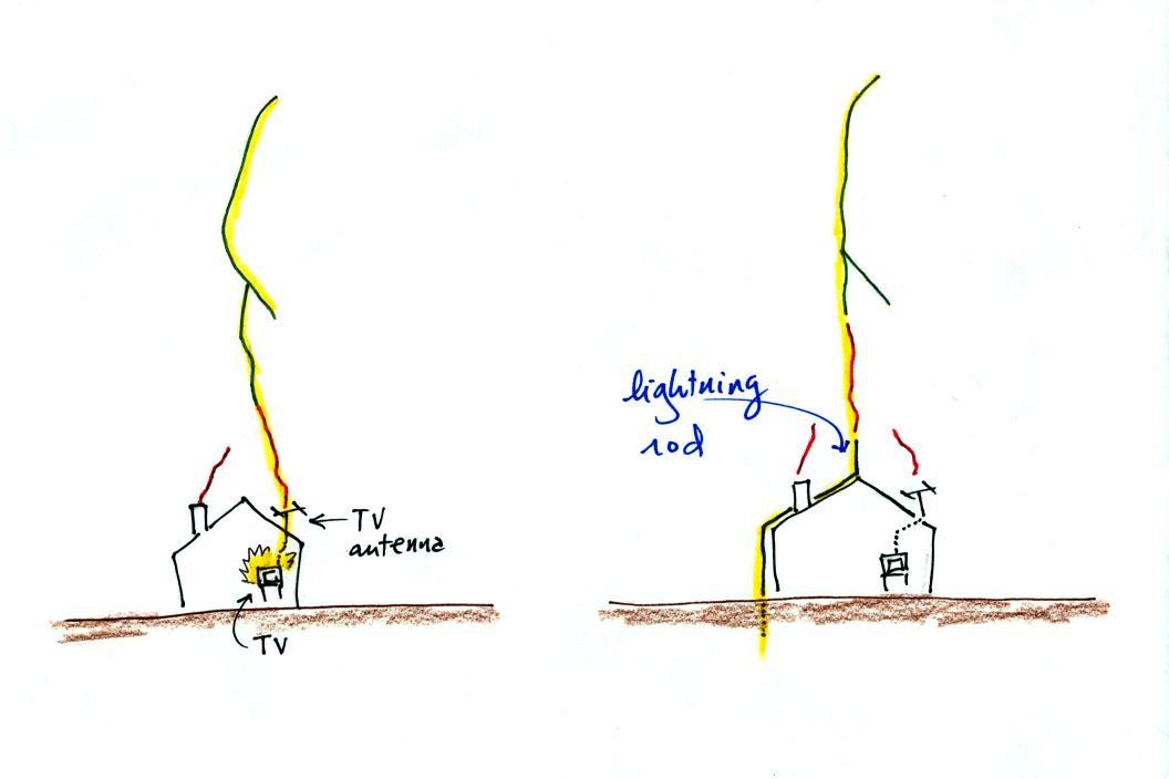
Houses with and without lightning rods are shown above. When lightning strikes the house without a lightning rod at left the powerful return stroke travels into the house destroying the TV and possibly starting the house on fire. With a lightning rod, an upward discharge launched off the top of the lightning rod intercepts the stepped leader and safely carries the lightning current through a thick wire around the house and into the ground. Lightning rods do work and they have changed little since their initial development in the 1700s. Most of the newer buildings on campus are protected with lightning rods. If you look carefully at the roof of Old Main, which was recently remodeled, you'll see lightning rods.
The connection between the stepped leader and the upward discharge creates a "short circuit" between the charge in the cloud and the charge in the ground.
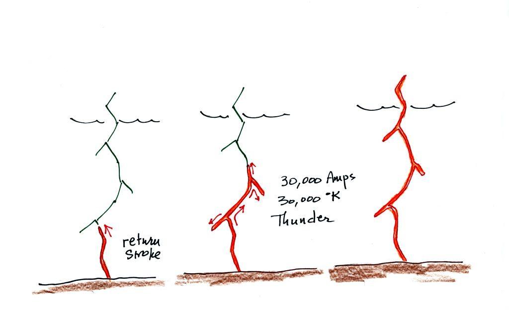
A powerful current travels back up the channel from the ground toward the cloud. This is the 1st return stroke. Large currents (typically 30,000 amps in this 1st return stroke) heat the air to around 30,000K (5 times hotter than the surface of the sun which is 6000 K) which causes the air to explode. When you hear thunder, you are hearing the sound produced by this explosion.
The figure below summarizes what we've covered so far in simplified form
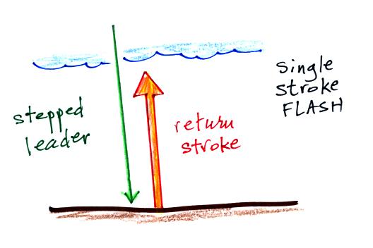
Does lightning travel upward
or downward? The answer is it does both. It
starts with a downward leader than is followed by an upward
moving return stroke.
Many cloud-to-ground flashes end at this point. In about 50% of cloud to ground discharges, the stepped leader-upward discharge-return stroke sequence repeats itself (multiple times) with a few subtle differences. That's covered below.
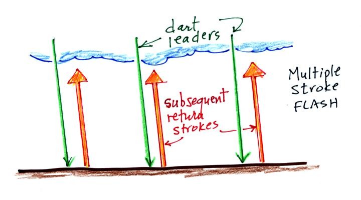
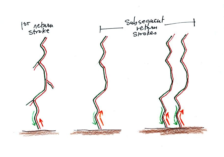
5. Multiple strokes flashes - dart leaders and subsequent return strokes
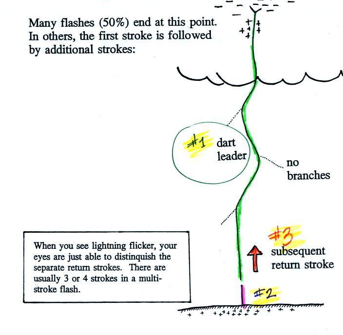
Many cloud-to-ground flashes end at this point. In about 50% of cloud to ground discharges, the stepped leader-upward discharge-return stroke sequence repeats itself (multiple times) with a few subtle differences. That's covered below.
5. Multiple strokes flashes - dart leaders and subsequent return strokes
A downward dart leader
travels from the cloud to the ground. The dart leader
doesn't step but travels smoothly and follows the channel
created by the stepped leader (avoiding the
branches). It is followed by a slightly less
powerful subsequent return stroke that travels back up the
channel to the cloud. This second stroke might be
followed by a third, a fourth, and so on. The
subsequent return stroke channel usually doesn't have
branches.
Here's a stepped leader-upward connecting discharge-return stroke animation (you'll see the stepped leader, upward discharges, and the first return stroke. Two additional subsequent strokes are shown without the dart leader).
6. Positive lightning
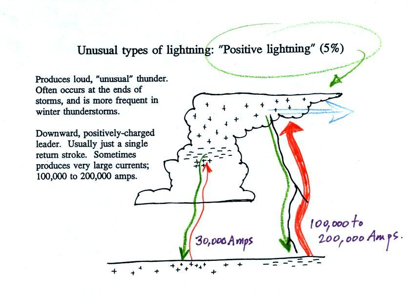
We've been looking at strikes that originate in the negative charge center is a thunderstorm (discharge at left in figure above). Occasionally a lightning stroke will travel from the positive charge region in the top of the thunderstorm cloud to ground (shown at right in the figure above). These types of strikes are more common at the ends of storms and in winter storms. This is probably because the top part of the cloud gets pushed sideways away from the middle and bottom portions of the cloud. Positive strokes are very powerful. They sometimes produce an unusually loud and long lasting clap of thunder.
7. Upward lightning
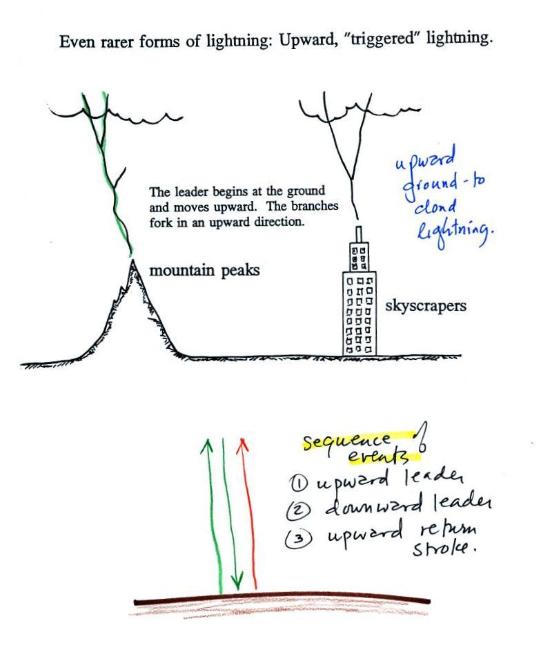
Here's an even rarer form of lightning. Lightning sometimes starts at the ground and travels upward. Upward lightning is generally only initiated by mountains and tall objects such as a skyscraper or a tower of some kind (the Empire State Building is struck many times every year but lightning and usually it's lightning that the building itself caused).
Note the discharge is different in another way also. These discharges are initiated by an upward leader. This is not followed by a return stroke, like you might expect, but by a more normal downward leader. Once the 2nd leader reaches the ground, an upward return stroke travels back up the channel to the cloud.
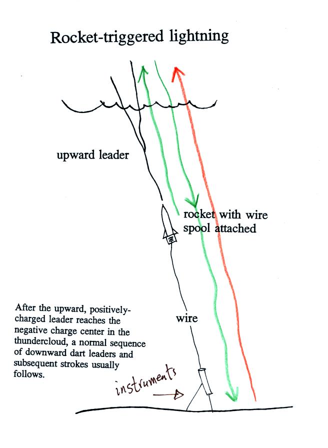
The fact that lightning
could begin with an upward discharge that begins at the
ground led (French) scientists to develop a technique to
trigger lightning by firing a small rocket up toward a
thunderstorm. The rocket is connected by a thin wire
to the ground. When the rocket gets 50 to 100 m above
the ground an upward streamer will develop off of the top of
the wire. Once the streamer reaches the cloud it can
initiate a "normal" series of downward dart leaders and
upward subsequent return strokes.
Scientists are able to take closeup photographs and make measurements of lightning currents using triggered lightning. Triggered lightning can also be used to test the operation of lightning protection devices.
Here's a link to the video that was showed in class.
The abbreviation NLDN that you'll see at the start of the video stands for National Lightning Detection Network. The headquarters of this company is located here in Tucson.
In the first 1:30 of the video you'll see natural lightning occurring in the Tucson area during the summer (both intracloud and cloud to ground discharges). Look for the flickering that means multiple return strokes in a flash.
Between 1:30 and about 2:00 you'll see lightning activity photographed at the Grand Canyon. Lightning at the Grand Canyon preferentially strikes the edges of the canyon, a location to avoid if you're there during a thunderstorm.
Next, between about 2:00 and 2:40 photographs of lightning striking large wind turbines in Kansas. A lightning strike to one of the turbine blades can cause damage that is very expensive to repair. At 2:16 and again at about 2:24 you'll see very bright lightning flashes that momentarily overexpose the video. These are probably positive cloud to ground discharges. And look carefully at the discharge that occurs between about 2:28 and 2:31 on the video. Notice the upward pointing branching. This was an upward discharge initiated by one of the wind turbines.
The remainder of the video shows rocket triggered lightning. These experiments were done at the International Center for Lightning Research and Testing (ICLRT) run by the University of Florida near Gainesville, FL.
A student asked a question, after the video, about what causes the green color that is sometimes seen in photographs of triggered lightning. The answer that is probably from vaporization of the copper wire that is carried upward by the rocket. If you're someone that enjoys watching lightning storms you may remember having seen a green glow when lightning strikes the ground. This is often produced by an exploding transformer on an electric power pole. The copper wire in the transformer is vaporized by the lightning.
The vaporization of different chemical compounds is what gives fireworks their distinctive colors. This link lists some of the chemical compounds and the colors they produce.
9. Fulgurites
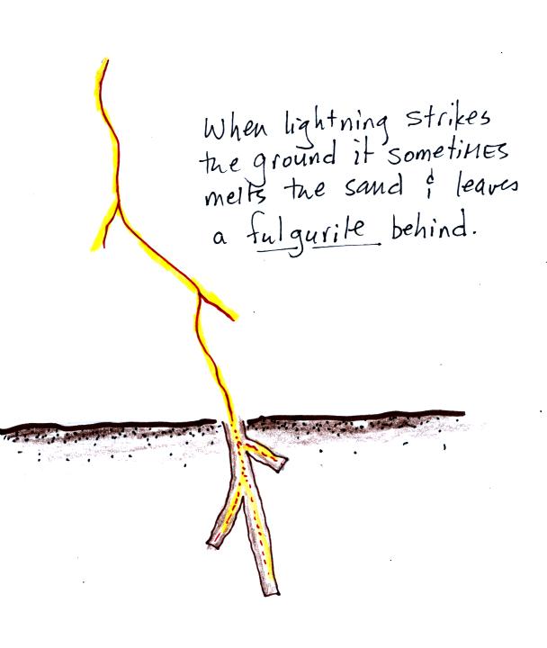
When lightning strikes the ground it will often melt the soil (especially sandy soil) and leave behind a rootlike structure called a fulgurite. A fulgurite is just a narrow (1/2 to 1 inch across) segment of melted sand (glass). Click here to see some actual photographs of fulgurites excavated at the University of Florida lightning triggering site.
10. Lightning safety
Lightning is a serious weather hazard. Here are some lightning safety rules that you should keep in mind during thundery weather.
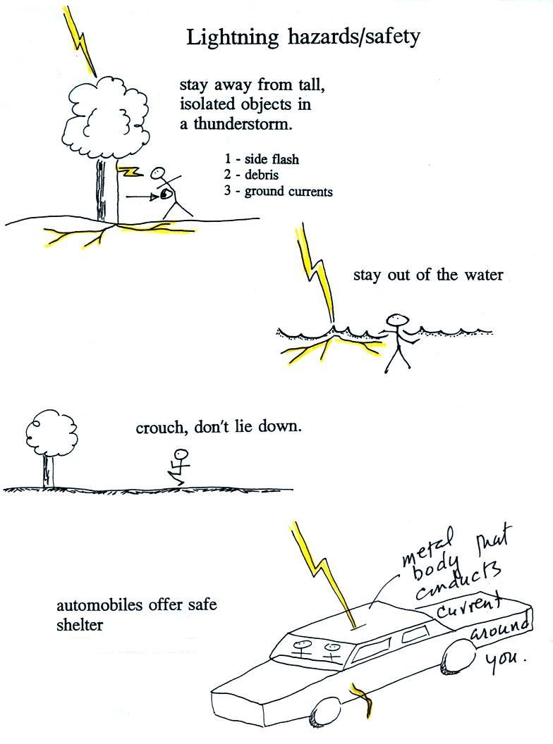
Stay
away
from
tall
isolated
objects
during
a
lightning
storm.
You
can
be
hurt
or
killed
just
by
being
close
to
a
lightning
strike
even
if
you're
not
struck
directly.
Lightning currents often travel outward
along the surface of the ground (or in
water) rather than going straight down into
the ground. Just being close to
something struck by lightning puts you at
risk. When
you hear of someone being struck by
lightning and living to tell about it, it
was often a nearby rather than a direct
strike.
An
automobile with a metal roof and body provides
good protection from lightning. Many
people think this is because the tires insulate
the car from the ground. But the real
reason cars are safe is that the lightning
current will travel through the metal and around
the passengers inside. The rubber tires
really don't play any role at all. The
people in Florida in the video that were
triggering lightning with rockets were inside a
metal trailer and were perfectly safe. All
of the connections made to equipment outside the
trailer were done using fiber optics, there were
no metal wires entering or leaving the
trailer.
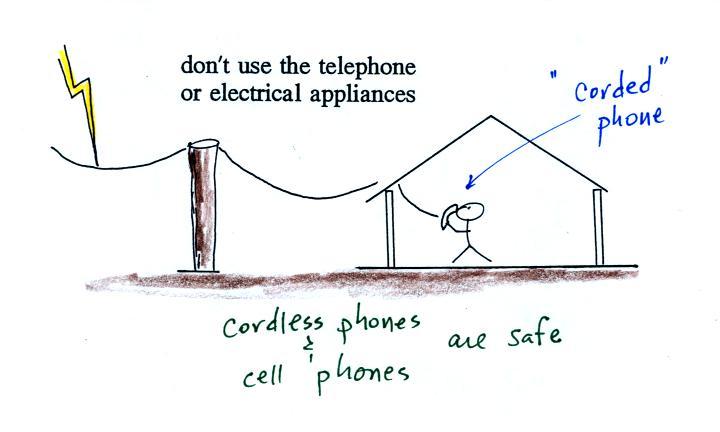
You shouldn't use a corded phone or electrical appliances during a lightning storm because lightning currents can follow wires into your home. Cordless phones and cell phones are safe. It is also a good idea to stay away from plumbing as much as possible (don't take a shower during a lightning storm, for example). Vent pipes are connected to the plumbing and go up to the roof of the house which puts them in a perfect location to be struck by lightning.
To estimate the distance to a lightning strike count the number of seconds between the flash of light and when you first hear the thunder. Divide this by 5 to get the distance in miles.
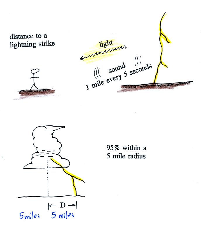
For example, a delay of 15 seconds between the flash of light and the sound of thunder would mean the discharge was 3 miles away. Research studies have shown that about 95% of cloud to ground discharges strike the ground within 5 miles of a point directly below the center of the storm. That's a 10 mile diameter circle and covers the area of a medium size city.
The latest lightning safety recommendation is the 30/30 Rule.
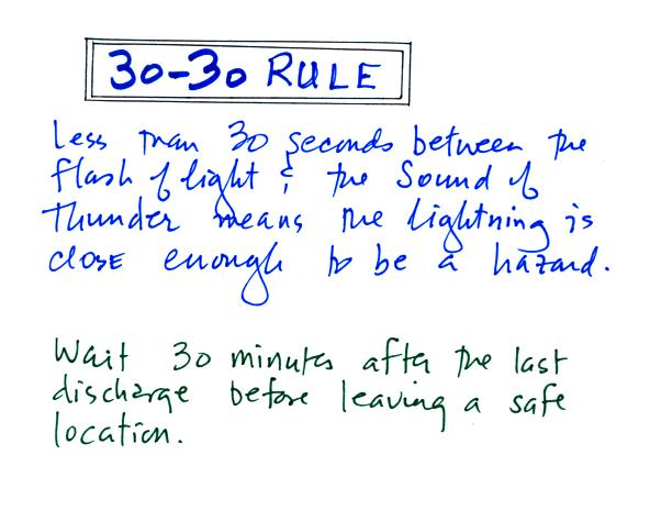
The 30/30 rule
People should seek shelter if the delay between a lightning flash and its thunder is 30 seconds or less
(the lightning is within 6 miles).
People should remain under cover until 30 minutes after the final clap of thunder. The powerful positive strokes often occur at the ends of thunderstorms.