![]()
![]()
![]()
![]()
Clouds typically form where air is rising upward in the atmosphere. As air rises, it expands and cools. As it cools, the air's capacity for water vapor (its saturation mixing ratio) decreases. If the air cools to its dew point temperature (in other words if it reaches saturation with respect to water vapor), condensation is forced and some of the water vapor in the air condenses into liquid water droplets. We will now take a more quantitative look at the process of cloud formation by tracking what happens to the temperature and water contained in parcels of air as they are raised and lowered in the atmosphere.
As long as the parcel is unsaturated (relative humidity < 100% or whenever the dew point temperature of the parcel less than the temperature of the parcel), the rate of cooling is 10°C for every 1000 meters the parcel is lifted.
As a rising parcel cools, its relative humidity increases. Once the relative humidity reaches 100% (determined when the parcel temperature cools down to its original dew point temperature), further lifting (and cooling) results in net condensation, forming a cloud. Remember that an air parcel will never contain more water vapor than its capacity or saturation mixing ratio.
Since condensation releases latent heat within the parcel, the rate of cooling is slower. Parcels which are saturated cool at a rate of 6°C for every 1000 meters the parcel is lifted. Also keep in mind that once a cloud begins to develop in a parcel, just enough water vapor will condense into liquid water so that the air in the parcel remains saturated (relative humidity = 100% and the dew point temperature equals the air temperature inside the parcel).
When lowering an air parcel in the atmosphere, the temperature changes are reversed. If there is no cloud (liquid water) in the parcel, the air temperature in the parcel increases at a rate of 10°C for every 1000 meters the parcel is lowered.
If there is a cloud in the parcel, it will evaporate because as the parcel warms its capacity for water vapor increases. As long as there is still a cloud (liquid water) in the parcel, just enough water will evaporate to keep the relative humidity at 100% and the dew point temperature equals the air temperature. Since it takes energy to evaporate water, the rate of heating is slower. Parcels which contain an evaporating cloud warm at a rate of 6°C for every 1000 meters the parcel is lowered until the entire cloud has evaporated.
You are expected to apply the rules above to fill in tables that keep track of the air temperature and dew point temperature of the air in a parcel that is moving up or down in the atmosphere. An example of a "blank" table is given below. You are expected to fill in the missing values in the table for a parcel of air forced to move upward from 0 meters to 6000 meters above sea level.
|
Altitude (meters above sea level) |
Parcel Temperature (°C) |
Parcel Dew Point Temperature (°C) |
Saturated? |
|
6000 m |
|
|
|
|
5000 m |
|
|
|
|
4000 m |
|
|
|
|
3000 m |
|
|
|
|
2000 m |
|
|
|
|
1000 m |
|
|
|
|
0 m |
33° C |
3° C |
No |
The first thing to do is move the parcel upward until it cools to its dew point temperature or reaches saturation with respect to water vapor. Rising parcels that are unsaturated cool at a rate of 10° C per 1000 meters they are lifted. Note that the dew point temperature remains constant until saturation is reached. Since the dew point temperature is a measure of the amount of water vapor in the parcel, it does not change unless there is a phase change of water happening in the parcel.
|
Altitude (meters above sea level) |
Parcel Temperature (°C) |
Parcel Dew Point Temperature (°C) |
Saturated? |
|
6000 m |
|
|
|
|
5000 m |
|
|
|
|
4000 m |
|
|
|
|
3000 m |
3° C |
3° C |
Yes |
|
2000 m |
13° C |
3° C |
No |
|
1000 m |
23° C |
3° C |
No |
|
0 m |
33° C |
3° C |
No |
In this example, the parcel cools to saturation after it has been moved up to 3000 meters above sea level. This is the altitude where a cloud will start to form in the parcel. Once saturation is reached, condensation occurs as the parcel continues upward. Now the rate of temperature decrease becomes 6° C per 1000 meters of lifting due to the release of latent heat by condensation. Once condensation begins there are two influences on the temperature of the air within a rising parcel, cooling due to expansion and heating due to condensation. The cooling due to expansion wins out, but the rate of parcel cooling as it is lifted is now slower. Because the dew point temperature keeps track of the amount of water vapor in the parcel, it must decrease once a cloud begins to form by condensation (water vapor condensing to the tiny liquid droplets that make up a cloud). The decrease in the dew point temperature indicates that there is a decreasing amount of water vapor in the air parcel. The water does not disappear though, it is condensing into the liquid that is the cloud. You should realize that once a cloud begins to form that the dew point temperature in a rising air parcel will remain the same as the air temperature so that the relative humidity in the parcel stays at 100%.
|
Altitude (meters above sea level) |
Parcel Temperature (°C) |
Parcel Dew Point Temperature (°C) |
Saturated? |
|
6000 m |
-15° C |
-15° C |
Yes |
|
5000 m |
-9° C |
-9° C |
Yes |
|
4000 m |
-3° C |
-3° C |
Yes |
|
3000 m |
3° C |
3° C |
Yes |
|
2000 m |
13° C |
3° C |
No |
|
1000 m |
23° C |
3° C |
No |
|
0 m |
33° C |
3° C |
No |
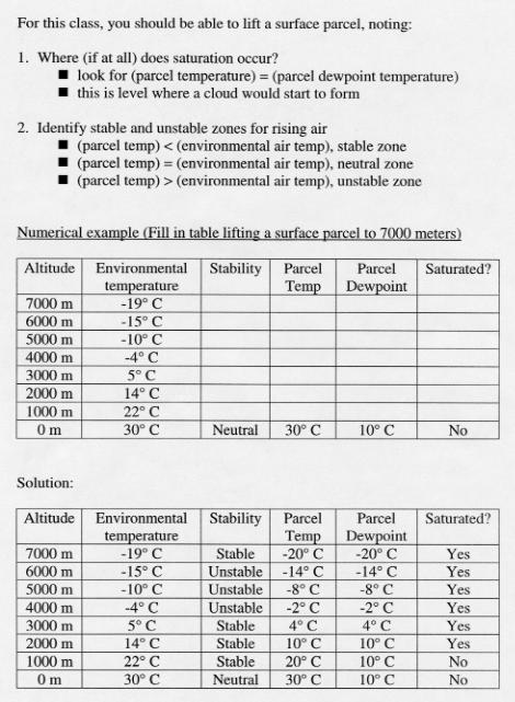
Now lets look at another numerical example. Below is a link to two tables. The first table shows you what you would know about the atmosphere before performing lifting a surface parcel upward. You would have to determine at what altitude a cloud would form by filling in the blanks. The second table shows the solution. NOTE: Please do not worry about the columns labeled environmental temperature and stability, we have not covered that material yet. You will be expected to do similar examples in homeork. Click Here to view the example.
Although the instructive method of filling in a table to keep track of what happens to air parcels as they rise is somewhat simplified, I believe it is very helpful in getting a first-order understanding of how clouds form. You will have to perform similar exercises in both homework problems and exams, so you should understand how to do it and the reasoning behind the rules for doing it.
In doing this we have ignored some of the complicating details. For example, air parcels do not remain completely isolated from the surrounding air, some mixing does occur. Also the rate of cooling of saturated parcels is not always 6°C per 1000 meters (as this is only an average). The actual cooling rate depends on how much water vapor condenses, which changes as the saturation mixing ratios change. Another detail is that the dew point temperature of rising parcels does not remain constant prior to saturation, but actually decreases slightly. You are not expected to consider these details for homework or exam questions.
![]()
![]()
![]()
![]()