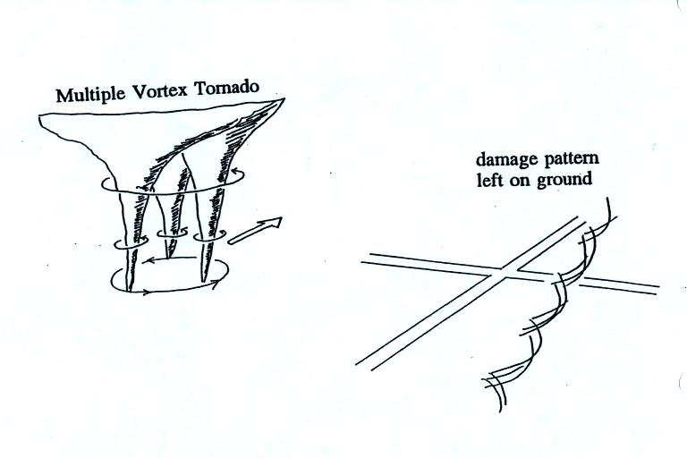
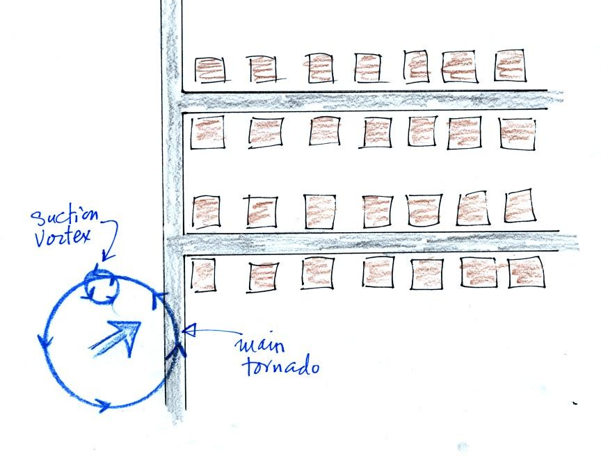
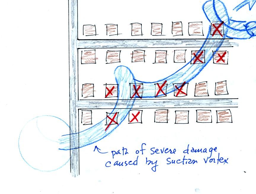
Wednesday Apr. 20, 2011
click here to download today's notes in a more printer friendly format

A little bluegrass from Alison Krauss and Union Station this morning ("Miles to Go", "Dimming of the Day" from her just released CD Paper Airplane and "Broadway" from a recording of a live performance in Louisville, KY)

The latest Optional Assignment was collected in class today.

The Quiz #4 Study Guide Pt.1 and Pt.2 are now available.  The Pt.1 Study Guide contains a lot of embedded links with examples to study.


A quick reminder of some of the key supercell thunderstorm features.


tilted rotating updraft (mesocyclone)
wall cloud (bottom of updraft)
dome (top of updraft)
flanking line
new storms trying to form
where downdraft winds collide with prexisting winds


Thunderstorms with rotating updrafts often have a distinctive radar signature called a hook echo.

We haven't discussed weather radar in this class yet.  In some ways a radar image of a thunderstorm is like an X-ray photograph of a human body.  The Xrays pass through the flesh but are partially absorbed by bone.


X-rays reveal the skeletonal structure.

In some respects, radar is similar


The radio signals emitted by radar pass through the cloud itself but are reflected by the much larger precipitation particles.  The intensity of the reflected signal (the echo) is color coded.  Red means an intense reflected signal and lots of large precipitation particles.  The edge of the cloud isn't normally seen on the radar signal.

Here are some actual radar images with prominent hook echoes.


This is the radar image of a thunderstorm that produced a very strong tornado that hit Oklahoma City in May 1999
( http://www.spc.noaa.gov/faq/tornado/radscel.htm ).  The hook echo is visible near the lower left hand corner of the picture.  Winds in the tornado may have exceeded 300 MPH.  You can read more about this tornado here.  And here is some storm chase video of the tornado.


It is very hard to actually measure the speed of the rotating winds in a tornado. Researchers usually survey the damage caused by the tornado to come up with a Fujita Scale rating. 

Here is the link to the photos that were shown in class with some discussion from the National Oceanic and Atmospheric Administration Storm Prediction Center.

The photographs below weren't shown in class.


Roof damage is typical of an F1 tornado.  The buildings on the left suffered light roof damage.  The barn roof at right was more heavily damaged.  Barns present a larger crossection to the wind and often aren't built as sturdily as a house.

More severe damage to what appears to be a well built house roof but still an F1 tornado.


Even relatively weak winds can damage a mobile home.  F1 tornado winds can easily tip over a mobile home if it is not tied down (the caption states that an F1 tornado could blow a moving car off a highway).  F2 level winds (bottom photo above) can roll and completely destroy a mobile home.


Trees, if not uprooted, can suffer serious damage from F1 or F2 tornado winds.

F1 winds will damage a roof, F2 level winds can completely remove the roof.  The outside walls of the building are still standing.

The roof is gone and the outer walls of this house were knocked down in the photo above.  This is characteristic of F3 level damage.  In a house without a basement or storm cellar it would be best to seek shelter in an interior closet or bathroom (plumbing might help somewhat to keep the walls intact).


In some tornado prone areas, people construct a small closet or room inside their home made of reinforced concrete.
A better solution might be to have a storm cellar located underground.


An F4 tornado knocked down all of the walls in the top photo but the debris is left nearby.   All of the sheet metal in the car body has been removed in the bottom photo and the car chasis has been bent around a tree.  The tree has been stripped of all but the largest branches.


An F5 tornado completely destroyed the home in the photo above and removed most of the debris.  Only bricks and a few pieces of lumber are left.


Several levels of damage (F1-F3) are visible in the photograph above.  It was puzzling initially how some homes could be nearly destroyed while a home nearby or in between was left with only light damage.  One possible explanation is shown below (from the bottom of p. 164 in the photocopied ClassNotes.


Some big strong tornadoes may have smaller more intense "suction vortices" that spin around the center of the tornado.  Tornado researchers have actually seen the pattern shown at right  scratched into the ground by the multiple vortices in a strong tornado.


The sketch above shows a tornado located SW of a neighborhood.  As the tornado sweeps through the neighborhood, the suction vortex will rotate around the core of the tornado.


The homes marked in red would be damaged severely.  The others would receive less damage.  Remember that there are multiple suction vortices in the tornado, but the tornado diameter is probably larger than shown here.

Air motions inside tornadoes are complex and difficult to study directly.  Researchers resort to laboratory simulations and computer models.  The figures below show some of the air motions thought to occur in tornadoes.


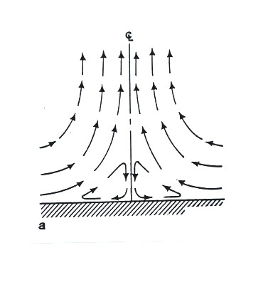
Wind motions in a fairly weak tornado.  The winds would also be spinning in addition moving upward as shown here.

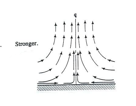
This tornado is a little stronger.


This tornado is even stronger.  The air in the center has started to sink (this is called vortex breakdown), but the sinking air doesn't reach the ground.  The diameter of the tornado has also grown.


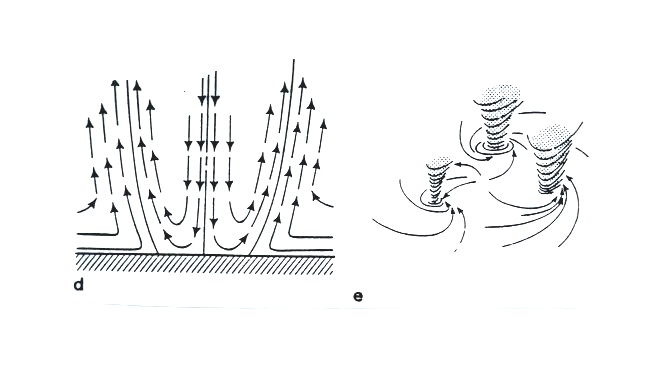
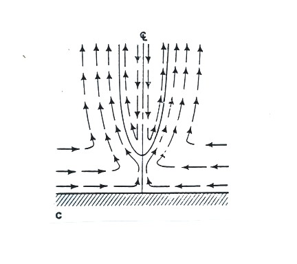
It is when the sinking air in the middle reaches the ground that multiple vortices may form. 


At this point we watched the last of the tornado video tapes.  It showed a tornado that occurred in Pampa, Texas (here are a couple of videos that I found on YouTube: video 1, video 2, they're missing the commentary that was on the video shown in class).  Near the end of the segment, video photography showed several vehicles (pick up trucks and a van) that had been lifted 100 feet or so off the ground and were being thrown around at 80 or 90 MPH by the tornado winds.  Winds speeds of about 250 MPH were estimated from the video photography (the wind speeds were measured above the ground and might not have extended all the way to the ground).