Friday Apr. 18
Bicycle drawings II (from the T Th
section)
Here's a scary thought
The Quiz #4 Study Guide has
made
its appearance in a very
preliminary form.
Any interest in an in-class Optional Assignment? The answer to
that question was yes, so a relatively long in class optional
assignment was handed out in class and collected at the end of the
period. The assignment will be returned next week and answers
will be posted somewhere online.
Any interest in extra Office Hours next week?
I actually forgot to ask that question. So if you're
reading this and think that is a good idea, just send me an email (
weidman@atmo.arizona.edu )
Remembering
what you learned about cloud-to-ground lightning in class on Wednesday,
can you make any
sense out of the following figure?
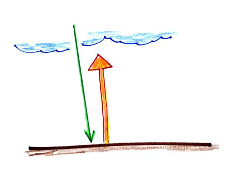
Which of these two discharges came first? What is the name
of that initial discharge? Click here for the answer.
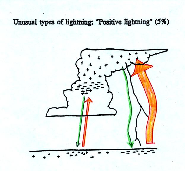
I believe we mentioned positive lightning in class on Wednesday.
A positive cloud-to-ground discharge begins with a downward moving positively charged leader.
That is followed by a very powerful return stroke (5 to 10 times more
current than negative cloud-to-ground lightning)
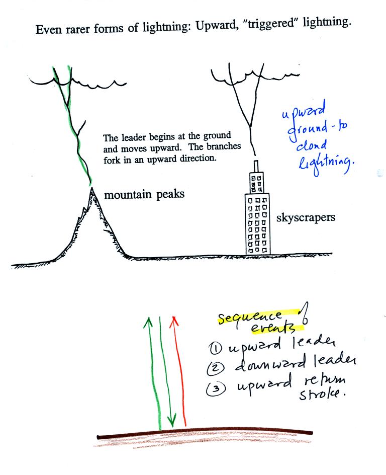
Lightning
sometimes starts at the ground and travels
upward.
Upward lightning is generally only initiated by mountains and tall
objects such as a skyscraper or a tower of some kind. These
discharges are initiated by an upward leader. This is followed by
a more normal downward leader and an upward return stroke.
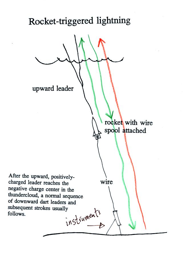
Scientists
are able to trigger lightning by firing a small
rocket up
toward a thunderstorm. The rocket is connected by a thin wire to
the ground. When the rocket gets 50 to 100 m above the ground
upward lightning will develop off of the top of the wire.
Scientists are able to take closeup photographs and make measurements
of lightning currents using triggered lightning. Triggered
lightning can also be used to test the operation of lightning
protection devices. A short video showing rocket triggered
lightning experiments was shown in class.
Near the end of the tape you will some cases where the
lightning didn't
follow the wire all the way to the ground (this is one reason why you
need to be very careful doing experiments of this type). When the
lightning strikes the sandy soil (instead of striking instruments on
the ground) it sometimes will leave behind a fulgurite (the spelling in
the figure is incorrect)
.
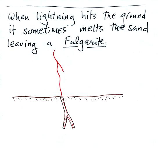

This is a drawing of a
science
fair project I once saw (I don't think it won a prize). If
10 to 20
Amps will cook a hotdog, imagine what the 10,000 to 30,000 Amps in a
lightning return stroke can
do to a person. It is best to try not to let that happen to you.

Stay away from tall isolated objects
during
a lightning
storm.
You can be hurt or killed just by being close to a lightning strike
even if you're
not struck directly.
An automobile with a metal roof and body provides good
protection from
lightning. The lightning current will travel through the metal
and around the passengers inside (the people in Florida that were
triggering lightning were inside a metal trailer and were perfectly
safe). The rubber tires really don't play any role at all.

You shouldn't use a corded phone and electrical
appliances
during a lightning storm because lightning currents can follow wires
into your home. Cordless phones and cell phones are safe.
To estimate the distance to a lightning strike
count the
number of
seconds between the flash of light and when you first hear the
thunder. Divide this by 5 to get the distance in miles.
The latest lightning safety recommendation is the 30/30 Rule. You
'll see that explained below.
The 30/30 rule
 People should seek shelter if the delay in seconds between
a lightning flash and its
thunder is 30 seconds or less.
People should seek shelter if the delay in seconds between
a lightning flash and its
thunder is 30 seconds or less.
People should remain under cover until
30 minutes after the final clap of thunder.
(for
further information see
Jetstream An Online School for Weather )
We had a
little extra time for a little introductory information on the next
topic we
will be covering - hurricanes.
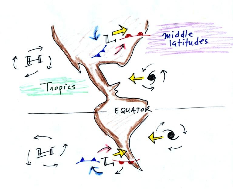
The figure above (a copy was distributed in
class) shows the two types of large synoptic scale storm systems:
middle latitude storms (extra tropical cyclones) and hurricanes
(tropical cyclones). The word cyclone is telling you that both
types of storms have at least one characteristic in common, winds
spinning around a surface center of low pressure. The winds spin
counterclockwise around low pressure in the northern hemisphere.
The winds reverse direction and spin clockwise around low pressure in
the southern hemisphere. The Coriolis force is what causes this
change. I hope to cover the Coriolis force at least briefly
before the end of the semester.
You may already have been
to the southern hemisphere or you may go there one day. You'll
probably hear about how the Coriolis force or the Coriolis effect
causes water to spin in a different direction in the southern
hemisphere when it is draining out of a sink and toilet bowl (it's not
true).
That's another reason for covering the Coriolis effect in NATS
101.
We'll compare middle latitude storms and hurricanes in a little more
detail next Monday. But notice that middle latitude storms
generally move from west to east in both the northern and southern
hemispheres. Hurricanes, on the other hand move from east to
west, again in both hemispheres. The next figure shows why this
is true.
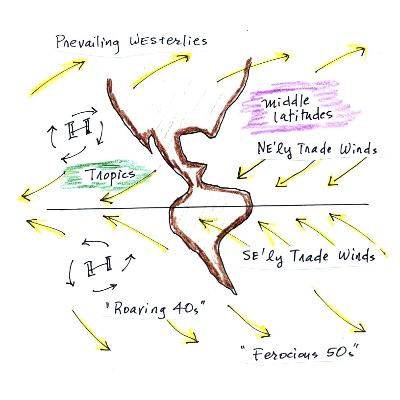
Winds blow from the west at middle latitudes (30 to 60
degrees latitude). These are called the prevailing
westerlies. The winds blow from the southwest in the northern
hemisphere and from the NW in the southern hemisphere. There is
very little land at middle latitudes in the southern hemisphere.
There is less friction when winds blow over ocean water and the
prevailing westerlies can get very strong in the southern hemisphere
especially in the winter. This is what the names "roaring 40s"
and "ferocious 50s" are referring to.
In the tropics (30 N to 30 S) winds blow from the east, form the NE in
the northern hemisphere and from the SE in the southern
hemisphere. These are the trade winds. The trade winds
converge at the equator and cause air to rise. This is referred
to as the Intertropical Convergence Zone (ITCZ). Since the air is
warm and moist clouds form and this is a rainy part of the globe.
Surface winds weaken at the equator and back when ships depended on
sails to move about the ships would sometimes get stuck near the
equator. This is the origin of the name "doldrums" used to
describe this part of the globe.