Wednesday, Mar. 27, 2019
Ravel's "Bolero"
played by the Copenhagen Philharmonic Orchestra (Sjællands
Symfoniorkester) at Copenhagen's Central Railway Station
(4:52), Gustav Holst "The Planets:
Jupiter The Bringer of Jollity" Berklee Contemporary
Symphony Orchestra at The Prudential Center (4:22), Edvard Grieg's
"In the Hall
of the Mountain King" Centre Commercial Auchan Noyelles,
Lille, France (6:00)
We'll be using page 103a,
page 103b, page 104a, page 99, and page 100 from the
ClassNotes today
This Snow
Crystal Morphology Diagram (from SnowCrystals.com)
illustrates how the shapes of snow crystals depends on temperature
and the amount of moisture in the air.
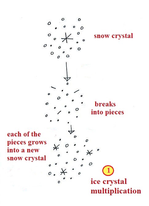
Inside a cold cloud, once
the ice crystal process is underway
A variety of things can happen once
a snow crystal forms.
First it can break into pieces, then
each of the pieces can grow into a new snow crystal.
Because snow crystals are otherwise in rather short supply,
ice crystal multiplication is a way of increasing the amount
of precipitation that ultimately falls from the cloud.
Snowflakes
Several snow crystals can collide and
stick together to form a snowflake. Snow crystals are
small, a few tenths of a millimeter across. Snowflakes
can be much larger and are made up of many snow crystals stuck
together. The sticking together or clumping together of
snow crystals is called aggregation (I frequently forget the
name of this process and don't expect you to remember it
either).
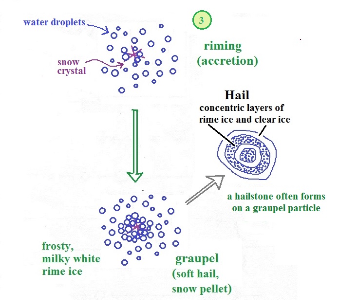
Riming (accretion) and graupel
(aka snow pellets & soft hail)
The next process and particle are something that I hope you
will remember.
Snow crystals can collide with
supercooled water droplets. The water droplets may stick
and freeze to the snow crystal. This process is called
riming or accretion (note this isn't called collision
coalescence even though it is the same idea). If a snow
crystal collides with enough water droplets it can be
completely covered with ice. The resulting particle is
called graupel. Graupel is sometimes mistaken for hail
and is called soft hail or snow pellets. Rime ice has a
frosty milky white appearance. A graupel particle
resembles a miniature snow ball. Or smaller finer
grained version of the shaved ice in a "snow cone."
Graupel particles often serve as the nucleus for a
hailstone. You'll find lots of pictures
on the internet (here is a nice side
by side comparison of graupel and hail from South New Jersey Today ).
Graupel is made of milky white
frosty rime ice. Sleet, we will find, is made of clear
ice. Here are some pictures to help you better appreciate
the differences in appearance.
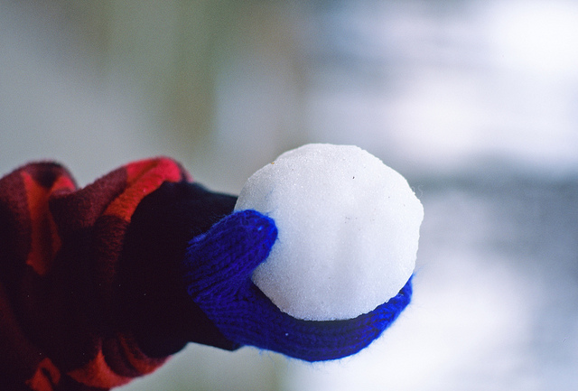
Here's a snowball. It's white
and you can't see through it. It's made up of lots
of smaller crystals of ice. Graupel is just a
small snowball.
source
|

The ice in a snow cone is basically
the same. Lots of smaller chunks of ice.
The ice is frosty white (before you added the flavored
syrup).
source
|
Graupel vs sleet, rime ice
vs clear ice
Graupel is sometimes referred as snow pellets. Sleet is
sometimes called ice pellets.
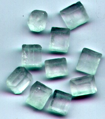
clear transparent sugar crystals
source of
this photograph
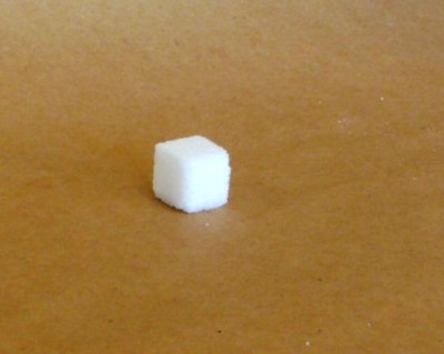
|
frosty white sugar cubes
are made up of many much smaller grains of sugar
|
Appreciating the differences in the appearance of clear ice and
rime ice.
Formation of hail
This figure (page
103b in the ClassNotes) gives you an idea of how hail
forms.

In
the figure above a hailstone starts with a graupel particle
(Pt. 1, colored green to represent rime ice). The
graupel falls or gets carried into a part of the cloud where
it collides with a large number of supercooled water droplets
which stick to the graupel but don't immediately freeze.
The graupel gets coated with a layer of water (blue) at Pt.
2. The particle then moves into a colder part of the
cloud and the water layer freeze producing a layer of clear
ice (the clear ice, colored violet, has a distinctly different
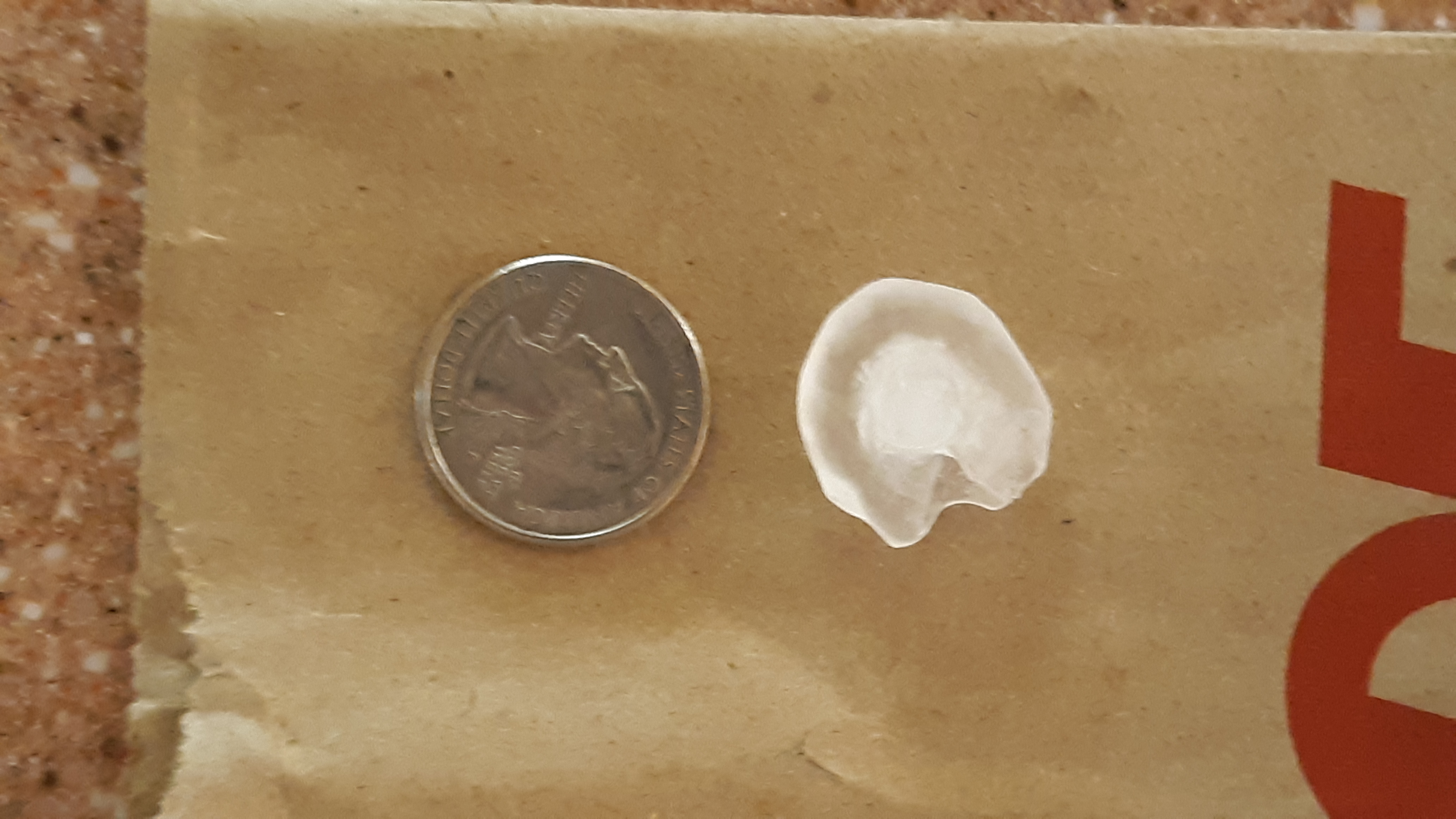
appearance from the milky white rime ice), Pt. 3. In Tucson this is often the only example of hail
that you will see: a graupel particle core with a single layer
of clear ice (you can look through the clear ice layer and see
the graupel inside, here is a link
to some photographs from a Arizona Daily Star June, 2015
article). You'll also find
photographs if you search "hail
crossection photograph"
Here's a photograph of a hail stone that fell from a
thunderstorm cloud in midtown Tucson during the Fall 2018
semester (photo credit: Jim Dugan). It clearly shows the
frosty white graupel particle surrounded by a layer of clear
ice. It's pretty unusual to get hailstones this large in
Tucson.
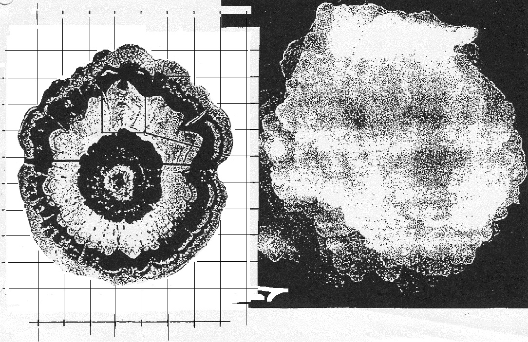
In the severe
thunderstorms in the Central Plains, the hailstone can pick
up additional layers of rime ice and clear ice and
hailstones can be composed of many alternating layers of rime and
clear ice. An unusually large hailstone (around
3 inches in diameter) has been cut in half to show (below)
the different layers of ice. The picture below is
close to actual size. If something like this were to
hit you in the head it would split your skull open.
Here's some pretty good video of a hailstorm
in Phoenix.
Hail is produced in strong thunderstorms
with tilted updrafts. You would never see hail (or
graupel) falling from a nimbostratus cloud. Here
is a photo of a record setting 8" diameter hailstone
collected in South Dakota. It is currently the national
record holder. Here's
another hailstone that is almost as big. It holds
the record for Oklahoma. Click here
to see a gallery of images showing hail damage to automobiles.
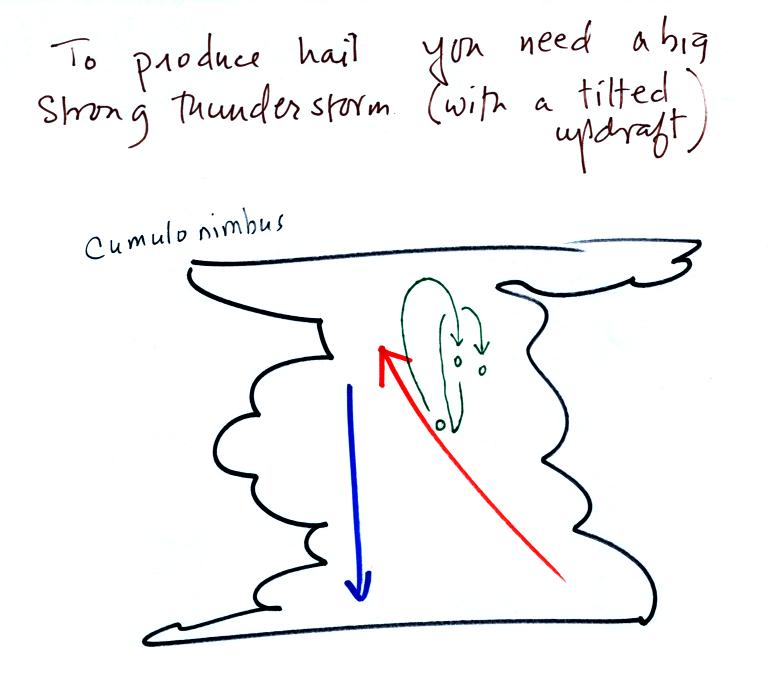
The growing hailstone can fall back into
the updraft (rather than falling out of the cloud) and be
carried back up toward the top of the cloud. In this way
the hailstone can complete several cycles through the interior
of the cloud. The article above mentions a supercell
thunderstorm. We will discuss these later in the semester.
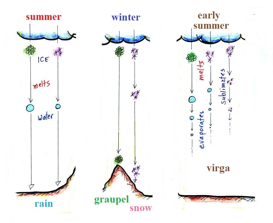
Types of precipitation
Finally on page
104a in the ClassNotes are illustrations of some of the
things that can happen once a precipitation particle falls from
a cloud. I've split this into two groups for clarity.
Essentially all the rain that falls in Tucson is
produced by the ice crystal process. The left figure above
shows how this happens. A falling graupel particle or a snow
flake moves into warmer air and melts. The resulting drops
of water fall the rest of the way to the ground and would be
called RAIN.
In the middle picture graupel particles can survive the trip to
the ground without melting even in the summer. Many people
on the ground would call this hail but that wouldn't be quite
right. Graupel is less common in the winter because it comes
from thunderstorms and they don't form very often in the
winter. Snow can survive the trip to the ground in the
winter but not the summer. Snow does occasionally make it to
the valley floor in Tucson.
Sometimes the falling raindrops will evaporate before reaching the
ground. This is called VIRGA and is pretty common
early in the summer thunderstorm season in Arizona when the air is
still pretty dry. Lightning that comes from thunderstorms
that aren't producing much precipitation is called "dry lightning"
and often starts brush fires.
Rain will sometimes freeze before reaching the ground.
The resulting particle of clear ice is called SLEET.
FREEZING RAIN by contrast only freezes once it reaches the ground.
Everything on the ground can get coated with a thick layer of
ice. It is nearly
impossible to drive during one of these "ice storms."
Sometimes the coating of ice is heavy enough that branches on
trees are broken and power lines are brought down (either by the
weight of ice or falling tree limbs). It sometimes takes
several days for power to be restored. Here's a gallery
of images taken after ice storms.
Satellite photographs of clouds
Now that we've finished the section on cloud identification
this is a good time to learn a little bit about the 2 most common
types of satellite photographs.
IR photographs
When you see satellite photographs of clouds on the TV weather
report you are probably seeing infrared satellite photographs.
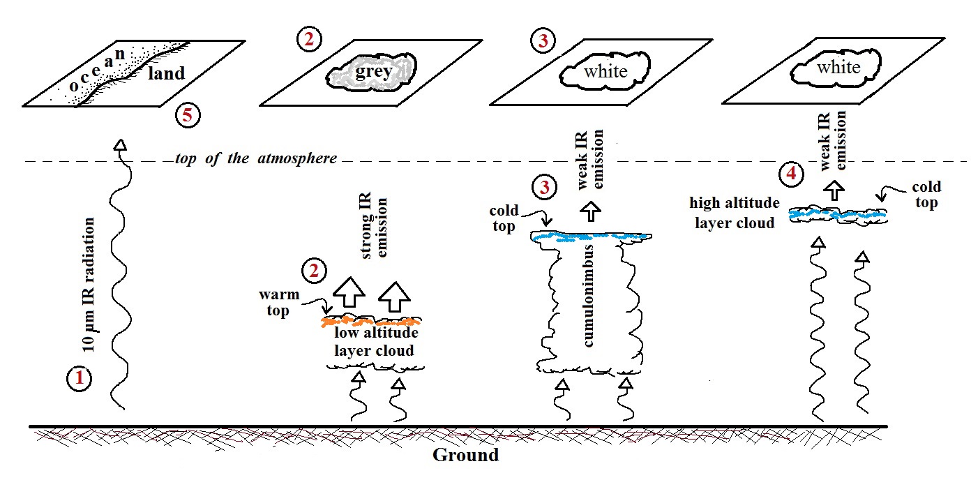
1. An infrared satellite photograph detects the 10
micrometer (μm) IR
radiation actually emitted by the ground, the ocean
and by clouds. You don't depend on seeing reflected
sunlight, so the earth can be photographed during the day and
at night. You may recall that 10 μm
radiation is in the middle of the atmospheric window, so this
type of radiation is able to pass through air without being
absorbed. If clouds don't get in the way, you can see
the ground on an IR photograph.
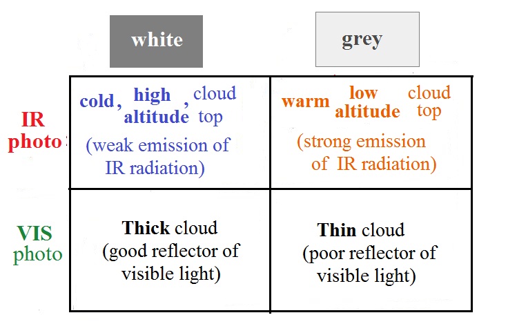
2. Clouds absorb 10 μm radiation
and then emit 10 μm IR
radiation of their own. The intensity of the cloud
radiation will depends on the cloud's temperature. The
top surface of a low altitude cloud will be relatively
warm. Warmer objects emit IR radiation at a greater rate
or at higher intensity (the Stefan Boltzmann law). This
is shown as grey on an IR satellite photograph. A
unimpressive grey looking cloud on an IR satellite photograph
may actually be a thick nimbostratus cloud that is producing a
lot of rain or snow.
3. Cloud tops found at high altitude are cold
and emit IR radiation at a lower rate or lower
intensity. This shows up white on an IR
photograph.
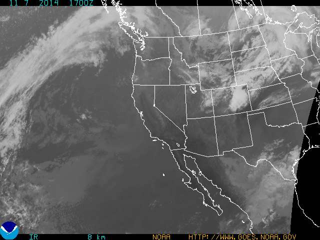
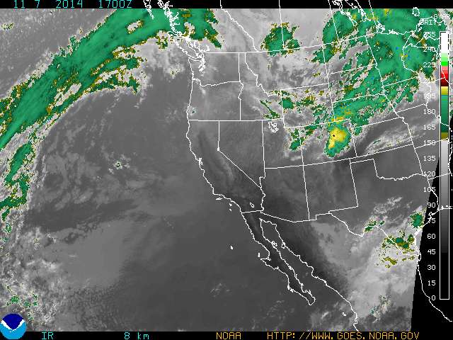
An example of an IR satellite photograph is shown
below. Slightly different shades of white or grey on IR
satellite photographs are difficult to distinguish with the
naked eye. The satellite sensor on the other hand is
able to precisely measure the intensity of the IR radiation it
is photographing. The images are often color enhanced to
bring out very small differences in intensity that are due,
ultimately, to differences in cloud temperature.
|
|
IR image
17 Z Nov. 7, 2014
|
color enhanced image
17 Z Nov. 7, 2014
|
The right image above is an enhanced version of the image
above at left (both images are from the National Oceanic and
Atmospheric Administration Geostationary
Satellite Server site). The intensity that
corresponds to a particular color can be determined using the
scale shown at the right edge of the image. For example
yellow appears to indicate an intensity of about 200 -
205. This corresponds to a temperature of about 215 K
(-58 C or -72 F)
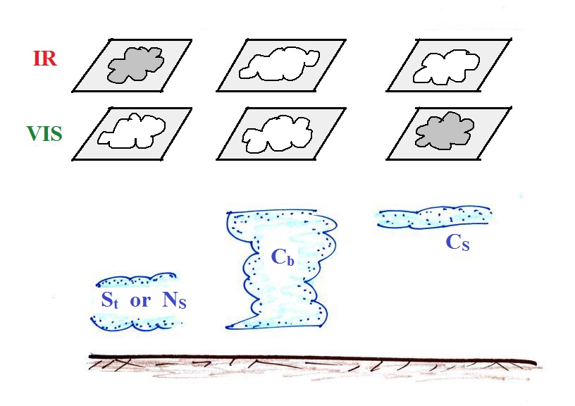
4. Two very different clouds (a thunderstorm
and a cirrostratus cloud) would both appear white on the
satellite photograph and would be difficult to
distinguish. Meteorologists are interested in locating
tall thunderstorms because they can produce severe
weather. Fortunately, as we will see, these two cloud
types have very different appearances of visible satellite
photographs, so this ambiguity can be resolved.
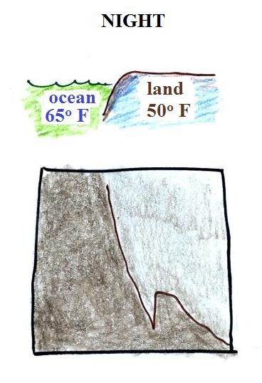
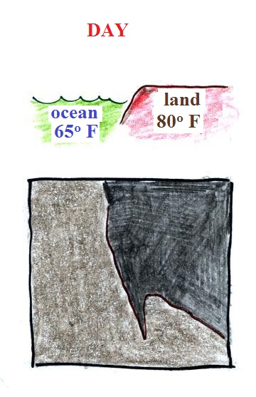
5. The ground changes temperature during
the course of the day. On an infrared satellite
animation you can watch the ground change from dark grey or
black (during the afternoon when the ground is warmest) to
lighter grey (early morning when the ground is cold) during
the course of a day. In the sketch below the ground
temperature varies between 80 F and 50 F during the day.
Because of water's high specific heat, the ocean right
alongside doesn't change temperature much during the day and
remains grey throughout the day. The ocean remains 65 F
throughout the day in the figure below.
|
|
Morning when
ground is cool
|
Afternoon when the
ground is warmer
|
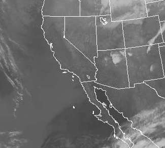
|
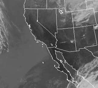
|
early morning (14 Z =
7 am MST)
|
afternoon (21 Z
= 2 pm MST)
|
Early morning (ground is cool) and afternoon (ground has
warmed) photographs are shown above. Focus in on the
center of the pictures (SW Arizona, S California, NW Mexico
and the northern end of Baja California). There don't
appear to be any clouds there so we are able to see the ground
and ocean. Note how much darker the ground appears in
the right (warm afternoon picture). I don't see a change
in the images of the ocean west of the California/Mexico
border in the two images
Here's a
link to an IR satellite photograph loop. It
is sometimes easier to see the changing appearance of the land
surface as it warms and cools when the pictures are in
motion.
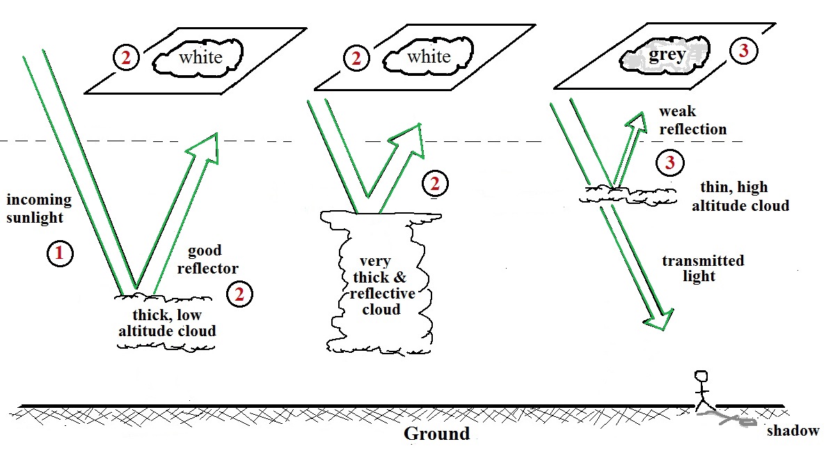
A visible satellite photograph photographs sunlight that is
reflected by clouds. You won't see clouds on a visible
satellite photograph at night. Thick clouds are good
reflectors and appear white. Thinner clouds don't reflect
as much light and appear grey. The low altitude layer
cloud and the thunderstorm above would both appear white on this
photograph and would be difficult to distinguish.
The table above summarizes what
we have learned so far.
The figure below shows
how
if
you
combine
both
visible
and
IR
photographs
you
can
begin
to
distinguish
between different types of clouds.
Low stratus or nimbostratus clouds appear grey and white on
infrared and visible photographs, respectively.
Thunderstorms appear white on both types of satellite photographs.
|
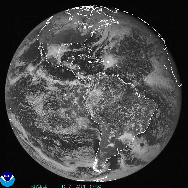
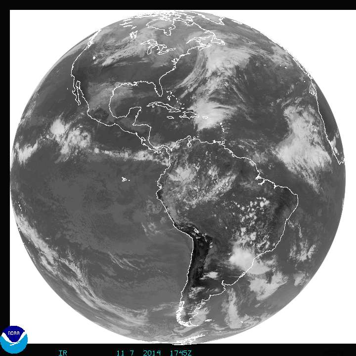
|
1745 Z (10:45 am MST) Full
Disk IR image
|
1745 Z Full Disk Visible image
|
A comparison of full disk INFRARED and VISIBLE images is shown
above. Perhaps the most obvious difference is the area of
clouds out over the Pacific Ocean and west of South America.
The clouds are bright white on the VIS image but barely
discernible on the IR image. These must be fairly thick low
altitude clouds, stratocumulus perhaps.
There's another even more striking difference between the two
images - the appearance of outer space. The earth appears on
a white background on the IR image. Remember that white on
an IR image indicates weak intensity IR emissions. In this
case the satellite is not detecting any IR emissions coming from
space - zero intensity IR radiation. The earth appears on a
black background in the VIS image. The satellite is not
seeing any visible light coming from space.
Geostationary orbit
The photographs above were taken from a satellite in
geostationary orbit. The satellite is positioned above the
equator at an altitude of about 22,000 miles altitude
(by comparison the International Space Station is about 260 miles
above the earth). At that altitude the satellite completes
one orbit a day. The motion of the satellite and the spin of
the earth are in the same direction. Thus the satellite
remains above and is always viewing the same point on the
ground.
Newest GOES 16 and GOES 17 satellites
Here's
a link to imagery from the GOES 16 (positioned over the
eastern US) and GOES 17 (positioned over the western US)