
NASA SPoRTVerified account
@NASA_SPoRT
SPoRT is a @NASA
project to transition unique observations & research to the
operational weather community to improve short-term forecasts on a
regional scale.

Tweets
- Tweets, current page.
- Tweets & replies
- Media
You blocked @NASA_SPoRT
Are you sure you want to view these Tweets? Viewing Tweets won't unblock @NASA_SPoRT
-
Pinned Tweet
You may view our real-time imagery at https://weather.msfc.nasa.gov/GOES/ .
Thanks. Twitter will use this to make your timeline better. Undo -
Thanks. Twitter will use this to make your timeline better. Undo
-
Late afternoon sun casting a shadow on Hurricane
#Irma's eye.#GOES16pic.twitter.com/CQaSgHzVN6Thanks. Twitter will use this to make your timeline better. Undo -
#Irma in the Day Land Convection RGB from#GOES16 this afternoon. Stay up to date with@NHC_Atlantic &@NWSpic.twitter.com/hOPe4Yzm0aThanks. Twitter will use this to make your timeline better. Undo -
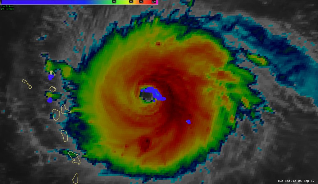
One can use lightning to track intense updrafts in the eyewall as they rotate around
#Irma's center. 1 minute#GOES16 GLM data 1513-1700 UTCpic.twitter.com/x3z3rmHYrSThanks. Twitter will use this to make your timeline better. Undo -
The gravity wave pattern emanating outward is astounding. Like someone dropping rocks into a pond. Hurricane
#Irma#GOES16pic.twitter.com/k4CphT0WfzThanks. Twitter will use this to make your timeline better. Undo -
Thanks. Twitter will use this to make your timeline better. Undo
-
#Lightning in#Irma's eyewall picking up in the last 1.5 hours, signaling intensity changes. From#GOES16 Geostationary Lightning Mapper.pic.twitter.com/UCTDFcHjiMThanks. Twitter will use this to make your timeline better. Undo -
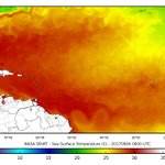
SPoRT Sea Surface Temperature product shows warm water along projected path of Hurricane
#Irma, favorable for maintaining strength.pic.twitter.com/74LoCroIZU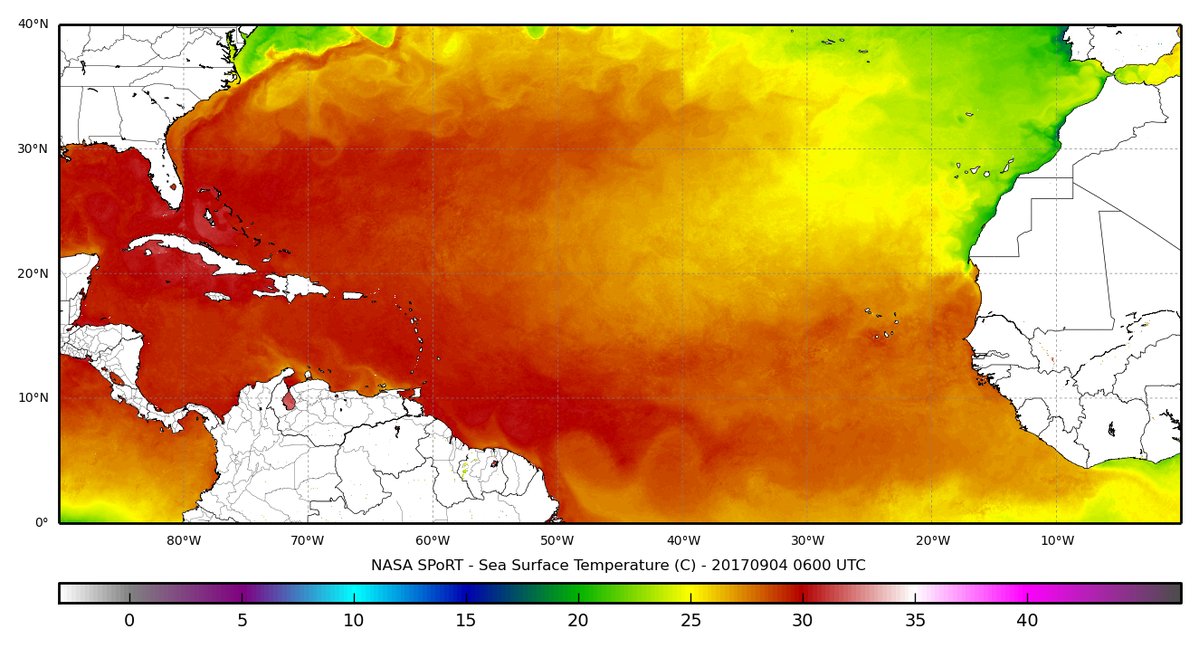
 Thanks. Twitter will use this to make your timeline better. Undo
 -
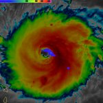
The eye of a category 5 hurricane.
#Irma#GOES16pic.twitter.com/eATVZspJZxThanks. Twitter will use this to make your timeline better. Undo -
Hurricane
#Irma has been upgraded to category 5 with SUSTAINED winds of 175 MPH.#GOES16pic.twitter.com/zh3U0YXPoaThanks. Twitter will use this to make your timeline better. Undo -
NASA SPoRT Retweeted
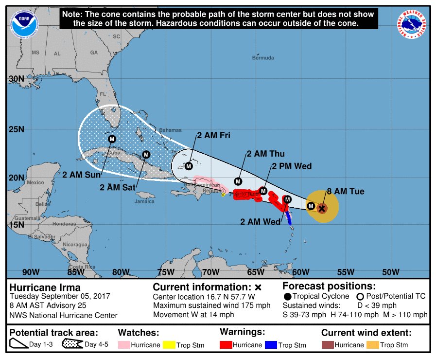
11pm AST forecast on
#Irma. Hurricane Warning issued for Puerto Rico and the U.S. and British Virgin Islands. http://Hurricanes.gov pic.twitter.com/GhwwXJCwym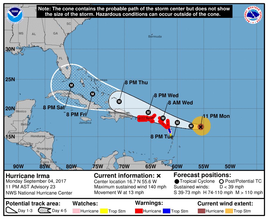 Thanks. Twitter will use this to make your timeline better. Undo
 -
#Irma is now a very dangerous category 4 hurricane with sustained winds of 130 MPH.#GOES16pic.twitter.com/POp5CMKKG2Thanks. Twitter will use this to make your timeline better. Undo -
Hurricane
#Irma has an open eye this morning.#GOES16pic.twitter.com/dhaNdhab4tThanks. Twitter will use this to make your timeline better. Undo -
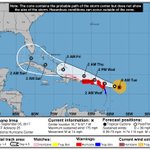
Center of
#Irma located ~750 miles east of the Lesser Antilles. Still lots of uncertainty with the track. See@NWSNHC for updates.#GOES16pic.twitter.com/rRipJa0tsSThanks. Twitter will use this to make your timeline better. Undo -
Here's a slightly zoomed out view of
#Irma.#GOES16pic.twitter.com/bnr6lzDKtzThanks. Twitter will use this to make your timeline better. Undo -
#Irma's intensity continues to fluctuate. Now back to Cat 3. Upward trend expected. Here's 1-minute#GOES16 meso sector visible imagery.pic.twitter.com/fCNTePJh9eThanks. Twitter will use this to make your timeline better. Undo -
#Irma had multiple eyewall replacements today. One-minute meso sector imagery will be avail tomorrow morning.#GOES16pic.twitter.com/1MAGocVw8nThanks. Twitter will use this to make your timeline better. Undo -
#Wildfires (red) and smoke (blue) are evident across Idaho, Montana, and British Colombia in this#GOES16 multispectral prod.#idwx#mtwxpic.twitter.com/4Pdq7MWKmXThanks. Twitter will use this to make your timeline better. Undo -
And a nod to
@DanLindsey77 for inspiring this post. :-)Thanks. Twitter will use this to make your timeline better. Undo -
Hurricane
#Irma's overshooting tops stand out in this loop due to#GOES16's oblique viewing angle.pic.twitter.com/aQWzFpkCh3Thanks. Twitter will use this to make your timeline better. Undo


Loading seems to be taking a while.
Twitter may be over capacity or experiencing a momentary hiccup. Try again or visit Twitter Status for more information.


