Monday Apr. 2, 2018
George Gershwin "Rhapsody
in Blue" (17:17) Los Angeles Philharmonic
Orchestra (directed by Leonard Bernstein)
We'll finish up the ice crystal process today and look at some
of the varieties of types of precipitation that can fall to the
ground. That probably won't take the whole class period so
we'll get started on some different material near the end of the
class.
Snow Crystals
Now we will see what can happen once the ice crystal has had a
chance to grow a little bit.
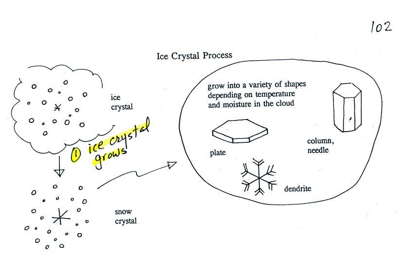
Once an ice crystal has grown a little bit it becomes a snow
crystal (this figure is on p. 102 in the ClassNotes). Snow
crystals can have a variety of shapes (plates, dendrites,
columns, needles, etc.; these are called crystal habits)
depending on the conditions (temperature and moisture) in the
cloud. Dendrites are the most common because they form
where there is the most moisture available for growth.
With more raw material available it makes sense there would be
more of this particular snow crystal shape.
Here
are some actual photographs of snow crystals (taken with a
microscope). Snow crystals are usually 100
or a few 100s of micrometers in diameter (tenths of a
millimeter in diameter). That's visible but you'd need
a microscope to see the detail shown above.
You'll find some much better photographs and a pile of
additional information about snow crystals at www.snowcrystals.com.
Here's another
source of some pretty amazing photographs.
A variety of things can happen once
a snow crystal forms.

First it can break into pieces, then
each of the pieces can grow into a new snow crystal.
Because snow crystals are otherwise in rather short supply,
ice crystal multiplication is a way of increasing the amount
of precipitation that ultimately falls from the cloud.
Snowflakes

Several snow crystals can collide and
stick together to form a snowflake. Snow crystals are
small, a few tenths of a millimeter across. Snowflakes
can be much larger and are made up of many snow crystals stuck
together. The sticking together or clumping together of
snow crystals is called aggregation (I frequently forget the
name of this process and don't expect you to remember it
either).
Riming (accretion) and graupel
(aka snow pellets & soft hail)
The next process and particle are something that I hope you
will remember.
Snow crystals can collide with
supercooled water droplets. The water droplets may stick
and freeze to the snow crystal. This process is called
riming or accretion (note this isn't called collision
coalescence even though it is the same idea). If a snow
crystal collides with enough water droplets it can be
completely covered with ice. The resulting particle is
called graupel. Graupel is sometimes mistaken for hail
and is called soft hail or snow pellets. Rime ice has a
frosty milky white appearance. A graupel particle
resembles a miniature snow ball. Or smaller finer
grained version of the shaved ice in a "snow cone."
Graupel particles often serve as the nucleus for a
hailstone. You'll find lots of pictures
on the internet (here is a nice side
by side comparison of graupel and hail from South New Jersey Today ).
Graupel is made of milky white
frosty rime ice. Sleet, we will find, is made of clear
ice. Here are some pictures to help you better appreciate
the differences in appearance.

Here's a snowball. It's white
and you can't see through it. It's made up of lots
of smaller crystals of ice. Graupel is just a
small snowball.
source
|

The ice in a snow cone is basically
the same. Lots of smaller chunks of ice.
The ice is frosty white (before you added the flavored
syrup).
source
|
Graupel vs sleet, rime ice
vs clear ice
Graupel is sometimes referred as snow pellets. Sleet is
sometimes called ice pellets.
clear transparent sugar crystals
source of
this photograph
|

frosty white sugar cubes
are made up of many much smaller grains of sugar
|
Appreciating the differences in the appearance of clear ice and
rime ice.
Formation of hail
This figure gives you an idea of
how hail forms.

In
the figure above a hailstone starts with a graupel particle
(Pt. 1, colored green to represent rime ice). The
graupel falls or gets carried into a part of the cloud where
it collides with a large number of supercooled water droplets
which stick to the graupel but don't immediately freeze.
The graupel gets coated with a layer of water (blue) at Pt.
2. The particle then moves into a colder part of the
cloud and the water layer freeze producing a layer of clear
ice (the clear ice, colored violet, has a distinctly different
appearance from the milky white rime ice), Pt. 3. In Tucson this is often the only example of hail
that you will see: a graupel particle core with a single layer
of clear ice (you can look through the clear ice layer and see
the graupel inside, here is a link
to some photographs from a Arizona Daily Star June, 2015
article). You'll also find
photographs if you search "hail
crossection photograph"
In the severe thunderstorms in the Central Plains, the hailstone
can pick up additional layers of rime ice and clear ice and
hailstones can be composed
of many alternating layers of rime and clear ice. An
unusually large hailstone (around 3 inches in diameter) has been
cut in half to show (below) the different layers of ice.
The picture below is close to actual size. If something
like this were to hit you in the head it would split your skull
open. Here's some pretty good video of a hailstorm in
Phoenix.

Hail is produced in strong thunderstorms
with tilted updrafts. You would never see hail (or
graupel) falling from a nimbostratus cloud. Here
is a photo of a record setting 8" diameter hailstone
collected in South Dakota. It is currently the national
record holder. Here's
another hailstone that is almost as big. It holds
the record for Oklahoma. Click here
to see a gallery of images showing hail damage to automobiles.

The growing hailstone can fall back into
the updraft (rather than falling out of the cloud) and be
carried back up toward the top of the cloud. In this way
the hailstone can complete several cycles through the interior
of the cloud. The article above mentions a supercell
thunderstorm. We will discuss these later in the semester.
Types of precipitation
Finally on p. 103 in the
ClassNotes are illustrations of some of the things that can
happen once a precipitation particle falls from a cloud.
I've split this into two groups for clarity.
Essentially all the rain that falls in Tucson is
produced by the ice crystal process. The left figure above
shows how this happens. A falling graupel particle or a snow
flake moves into warmer air and melts. The resulting drops
of water fall the rest of the way to the ground and would be
called RAIN.
In the middle picture graupel particles can survive the trip to
the ground without melting even in the summer. Many people
on the ground would call this hail but that wouldn't be quite
right. Graupel is less common in the winter because it comes
from thunderstorms and they don't form very often in the
winter. Snow can survive the trip to the ground in the
winter but not the summer. Snow does occasionally make it to
the valley floor in Tucson.
Sometimes the falling raindrops will evaporate before reaching the
ground. This is called VIRGA and is pretty common
early in the summer thunderstorm season in Arizona when the air is
still pretty dry. Lightning that comes from thunderstorms
that aren't producing much precipitation is called "dry lightning"
and often starts brush fires.
Rain will sometimes freeze before reaching the ground.
The resulting particle of clear ice is called SLEET.
FREEZING RAIN by contrast only freezes once it reaches the ground.
Everything on the ground can get coated with a thick layer of
ice. It is nearly
impossible to drive during one of these "ice storms."
Sometimes the coating of ice is heavy enough that branches on
trees are broken and power lines are brought down (either by the
weight of ice or falling tree limbs). It sometimes takes
several days for power to be restored. Here's a gallery
of images taken after ice storms.
This is the end of the material that will be
covered on this week's quiz.
How and why surface and upper level winds blow the way
they do.
Some real world examples are shown in the figure below (found
on p. 121 in the ClassNotes). The two largest types of storm
systems, middle latitude storms (extratropical cyclones) and
hurricanes (tropical cyclones), develop around surface centers of
low pressure
the term cyclone
refers to winds blowing around a center of low pressure
Earlier in the semester we learned that winds spin
counterclockwise around centers of low pressure in the northern
hemisphere. Tuesday next week is the day we start to worry
about what happens in the southern hemisphere. Winds change
direction and spin clockwise around low pressure in the southern
hemisphere.
Winds spin clockwise around "anticyclones" (high pressure) in the
northern hemisphere and counterclockwise around highs in the
southern hemisphere.
Why do winds blow in opposite directions around
high and low pressure. Why do they even spin at
all.
Why do the winds change directions when you move from the
northern to the southern hemisphere.
These are the kinds of questions we'll be addressing next
week. And it's not just the wind. Ocean
currents off the East and West Coasts of the US spin in a
clockwise direction. They reverse direction and spin
counterclockwise off the east and west coasts of South America.
Something else to notice in the figure. Storm systems
in the tropics (0 to 30 degrees latitude) generally move from
east to west in both hemispheres, in both
hemispheres. At middle latitudes (30 to 60 degrees),
storms move in the other direction, from west to east.
We'll be able to learn most of what we need to know about
surface and upper level winds in 10 relatively easy steps (though
I've broken several of the steps into smaller parts)
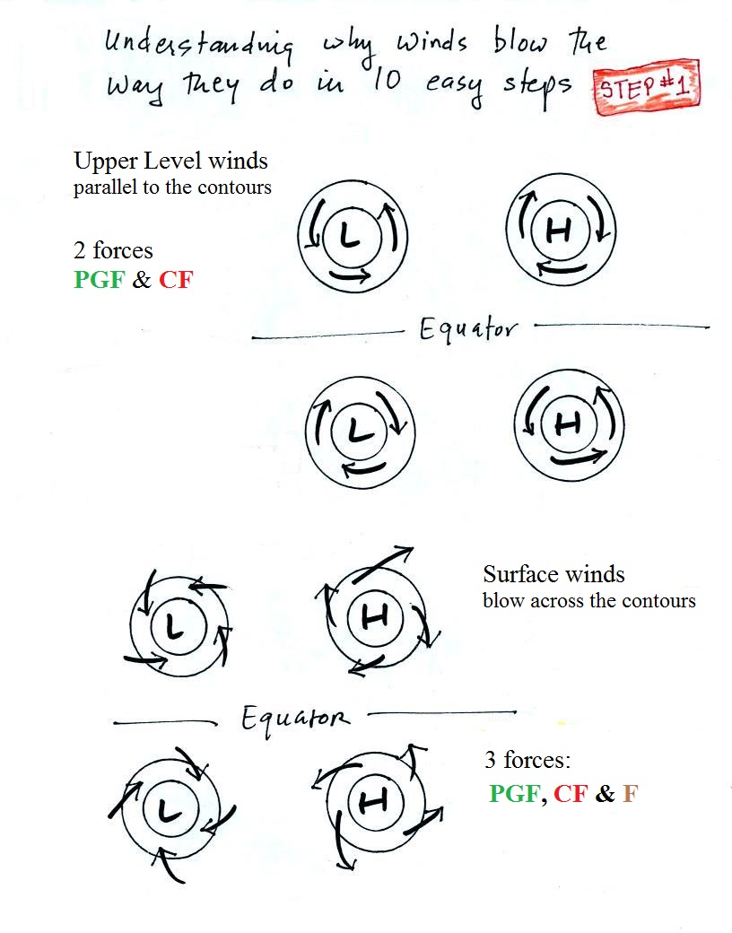
Step #1 - Upper level and surface winds in the N. and
S. hemisphere - summary
Upper level winds spinning around high and low pressure in the
northern and southern hemispheres are shown in the first set of
four pictures. All the possibilities are here. The
first thing to notice is that upper level winds blow parallel to
the contours. Just 2 forces, the pressure gradient force (PGF) and the Coriolis force (CF), cause the winds to blow this
way. Eventually you should be able to draw the directions of
the forces for each of the four upper level winds examples.
Here is an
upper level wind example showing what you should be able to
do.
The four drawings at the bottom of the page show surface winds
blowing around high and low pressure in the southern
hemisphere. Surface winds blow across the contour lines
slightly, always toward low pressure. A third force,
the frictional force is what causes this to occur. He
is an example of
what you will be able to say about surface winds.