Friday Apr. 18, 2014
Pavarotti & Sting "Panis
Angelicus" on a Friday morning before Easter. You can
read more about the song itself here.
All of the various reports turned in earlier this week have
been graded and were returned in class today. The Expt. #3
revised report are due next Wednesday, April 23. Everything
else is due the Wednesday after than, April 30.
The 1S1P reports on the Koppen Climate Classification system
have all been graded and were returned. There
was a large discrepancy between the average grades from Grader #2
(the easier grader) and Grader #3. Because of that 3 points
were added to all of the reports graded by Grader #3.
I'm hoping to have grade summaries ready to hand out in class
next Wednesday. They will include the 1S1P reports on
Rainbows, Mirages, and the Green Flash but not the topics turned
in this week on Regional Winds & Foucault's Pendulum.
And here's a scary thought. The Final Exam scheduled for
this section of the class is 3 weeks from today (3:30-5:30 pm).
The day was devoted to finishing up the material on the 3-cell
model, forces and winds. We'll start a new section on
Thunderstorms, Tornadoes, and Lightning next Monday. That
will take us up to Quiz #4 most likely.
We need to quickly reconstruct the map we were
working on at the end of class on Wednesday. We started with
the blank map below and added features in a step by step manner.
Leave some room off to the left for names of all
the features that need to be drawn in.
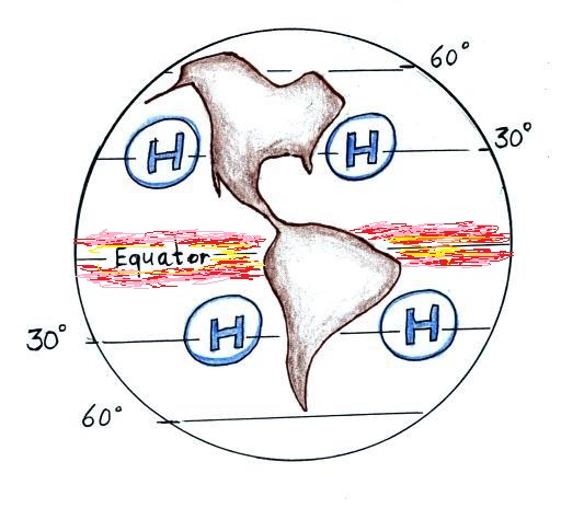
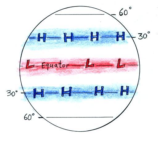
You need a starting point, I would suggest remembering
that there's a belt of low pressure at the equator, the
equatorial low. Then remember the belts of pressure
alternate. Low pressure at the equator and then high
pressure at 30 N and 30 S, these are the subtropical
highs. Winds move away from high pressure at 30 degrees
toward low pressure at the equator and low pressure at 60
degrees (not shown in the figure). The Coriolis force
turns the wind to the right in the NH and to the left in the
southern hemisphere.
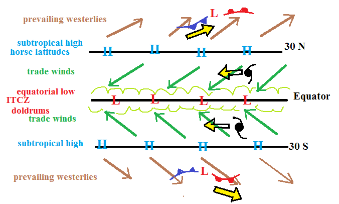
The winds blowing between the equator and 30 degrees latitude
are the trade winds. They converge at the equator and
form the intertropical convergence zone (ITCZ). The
convergence causes air to rise so this is a region of cloudy
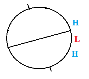
skies. The low pressure belt at the equator is also
referred to as the doldrums. This is a region of fairly
calm surface winds and sailing ships used to become stuck
there (becalmed I think is the word). Calm winds are
also found at 30 degrees latitude, the horse latitudes.
Winds found between 30 and 60 latitude blow from the west and
are called the prevailing westerlies.
Hurricanes and middle latitude storms have been drawn
in. Winds blow from the west between 30 and 60 degrees
latitude where middle latitude storms are found. Those
storms move from west to east. Hurricanes on the other
hand are found in the tropics between the equator and 30
degrees latitude. The trade winds move hurricanes from
east to west.
|
|
3-cell model
predictions:
belts of high and low pressure
|
important real world
features:
centers of high pressure &
a belt of low pressure at the equator
|
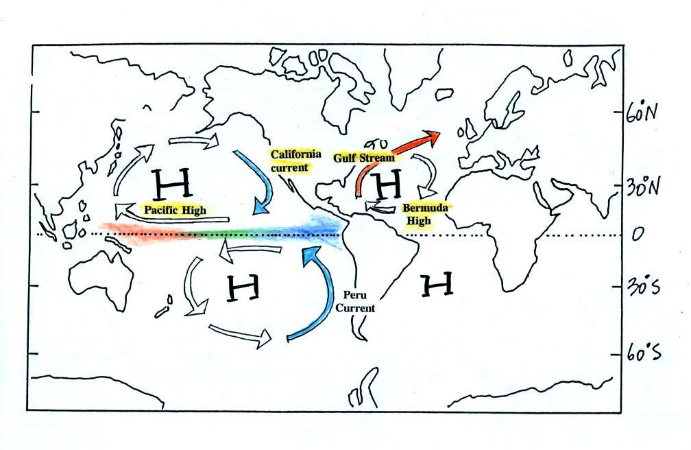
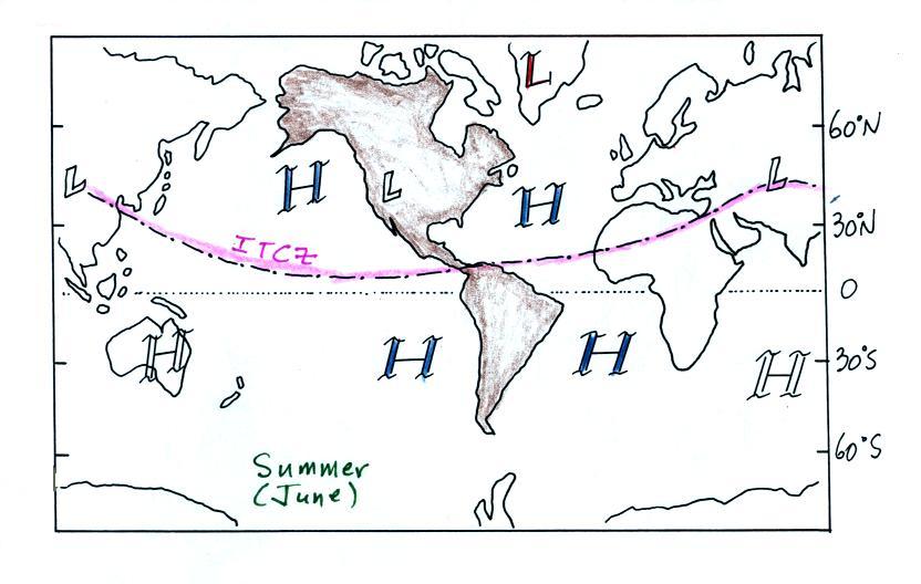
Here's the summer picture (North Pole tilted toward the
sun). The ITCZ which is normally found at the equator has
moved north of the equator.
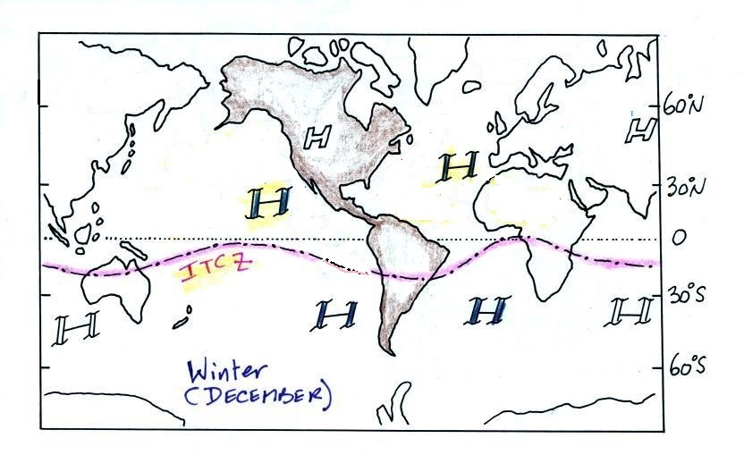
And the winter pictures, all the features have moved
southward.
The movement of the Pacific High north and south of its
nominal position near 30 degrees latitude is part of what causes
our summer monsoon in Arizona. The term monsoon is
often used incorrectly in S. Arizona to refer to a
thunderstorm.
A monsoon is a seasonal change
in the direction of the prevailing winds.
Probably the best known monsoon is the Indian Monsoon.
This was also discussed briefly in the notes from
Wednesday's class.
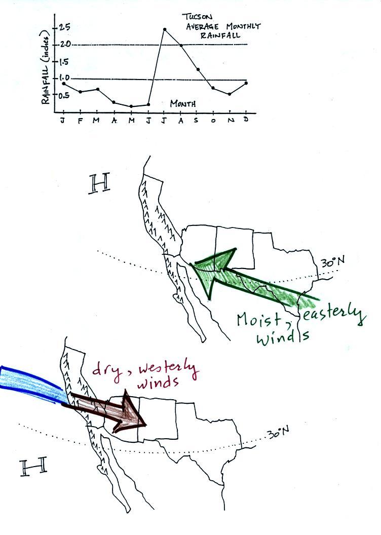
In the winter the Pacific High is
found south of 30 N latitude (the bottom of the figure
above). Winds to the north of the high blow from the
west. Air originating over the Pacific Ocean is moist
(though the coastal water is cold so this air isn't as moist as it
would be if it came off warmer water). Before reaching
Arizona the air must travel over high mountains in
California. The air loses much of its moisture as it does
this (remember the rain shadow effect). The air is pretty
dry by the time it reaches Arizona. Significant winter rains
occur in Arizona when storms systems are able to draw moist
subtropical air from the southwest Pacific ocean into Arizona.
During the summer, the
Pacific High moves north of 30 N latitude. Winds on the
southern side of the subtropical high have an easterly
component. Moist air originating in Mexico and from
over warm water in the Gulf of Mexico blows into Arizona.
The sun heats the ground during the day, warm moist air in contact
with the ground rises and produces convective thunderstorms.
Tucson gets about 12 inches of
rain in a normal year. About half of this comes during the
"summer monsoon" season.
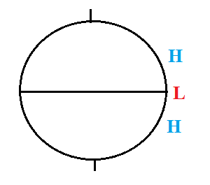
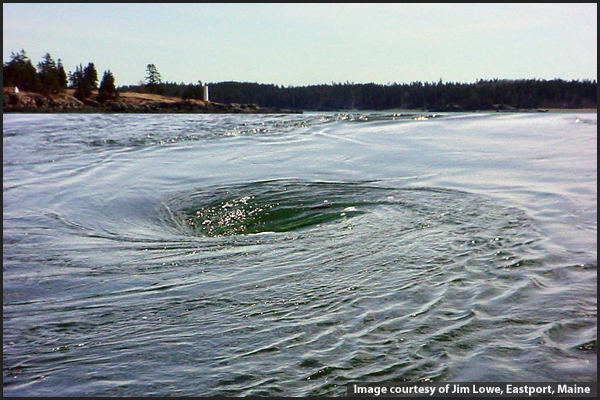
Lastly we returned to the toilet flushing experiment and a
common misconception involving the Coriolis force. You might
have heard that water spins in a different direction when it
drains from a sink or a toilet bowl in the southern hemisphere
than it does in the northern hemisphere. You might also have
heard that this is due to the Coriolis force or the Coriolis
effect.
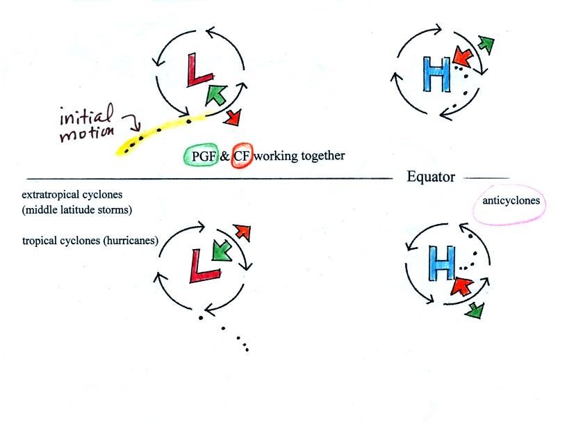
The Coriolis force does cause winds to spin in opposite directions
around large scale high and low pressure centers in the northern
and southern hemisphere. The PGF starts the air moving (in
toward low, out and away from high pressure) then the Coriolis
force bends the wind to the right (N. hemisphere) or to the left
(S. hemisphere).
Here's what you end up with in the case of low pressure.
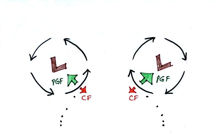
Just like a rock will always start to roll downhill and never
uphill, air starts to move inward toward low pressure (the dots
show this initial motion). Then the Coriolis force causes
it to turn to the right or left depending on which hemisphere
you're in. You should be able to say which of the pictures
above is the northern hemisphere and which is the southern
hemisphere picture.
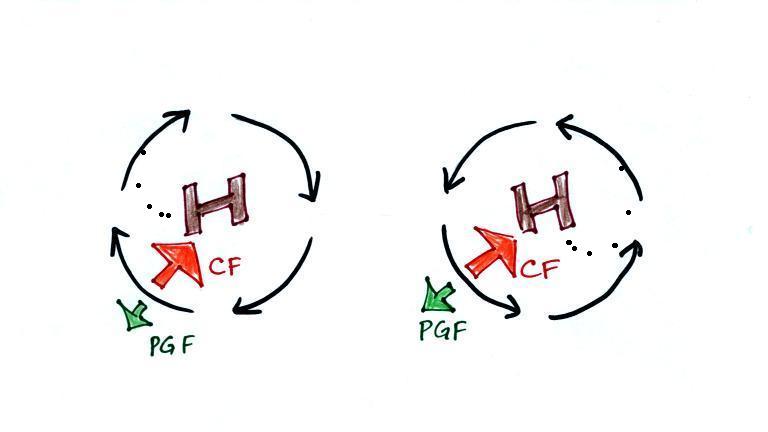
The same kind of idea applies to high pressure except that the
air starts moving outward. The Coriolis force then turns
it to the right or left.
Note that in all four cases above the inward pointing force
is stronger than the force pointing outward. This is what
provides the net inward force needed for something to move in a
circular path. The Coriolis force, because it
is the one pointing inward, plays a key role in this case.
An inward force is needed to keep anything moving in a circular
path.
The figures above were actually on a handout distributed in
class that looked like this.
Remember the term cyclone refers to winds spinning around a
center of low pressure. Anticyclone refers to high
pressure.
There are situations where the PGF is much stronger than the CF
and the CF can be
ignored. A tornado is an example. The PGF
is much much stronger than the CF and the CF can be
ignored.
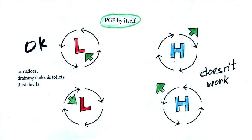
You need an inward pointing force in
order for wind to blow in a circular path. It
is possible for winds to spin around low pressure.
The inward pointing PGF provides the inward force that is
needed. The PGF points outward around centers of
high pressure. Winds can't spin around high pressure
when there is just a pressure gradient force.
There's nothing to supply the needed inward force.
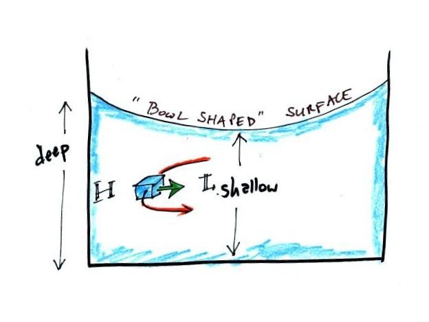
This is what happens when water drains from a sink or
toilet. The water can spin in either direction in
either hemisphere. What causes the inward pointing
PGF?
The water at the edges of the spinning
water is a little deeper than in the middle. Since
pressure depends on weight, the pressure at the outer edge of
the spinning water is higher than in the center. This
creates the inward pointing pressure gradient (pressure
difference) force.
Water draining from a sink or toilet can spin in
either direction. It doesn't matter where you're
located. The toilet flushing experiment should show
about equal numbers of clockwise and counterclockwise spinning
water. What has the experiment actually shown so far?
16 students have reported
counterclockwise spinning
18 students have reported clockwise spinning
You can't do too much better than that (the numbers had
changed a little bit by the 2 pm class: 17 CCW versus 24 CW).
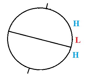
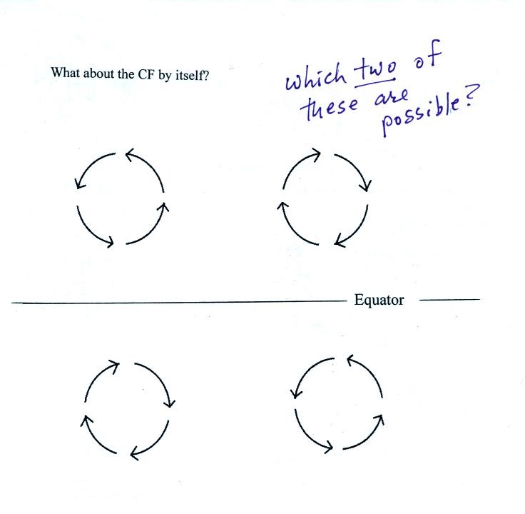
Class ended (a little early) with an opportunity to earn a Green
Card. The following figure was on the
back of the class handout.
Which two of the figures above would be possible if there were
just Coriolis Force and no pressure gradient force.
This a good question. It looks hard. Don't just guess
at the answer. Ask you self what do I know about the
Coriolis Force and circular motion. If you weren't in class
today you can still try to earn a Green Card .
Turn in a sheet of paper on Monday with your name and the answer
to the question above. Your answer should include some
explanation about how you solved the problem.