Quiz #1 Study Guide

Questions on Quiz #1 will come from topics on this study guide and the Practice Quiz Study Guide.  Be sure also to review the questions on the Practice Quiz and the two recent Optional Assignments.

Archimedes principle (5 - 10 pts).  An object immersed in a fluid (this can be a liquid like water or a gas like air) experiences an upward buoyant force that is equal to the weight of the fluid displaced by the object.  Basically objects that are less dense than the fluid around them float, objects that are denser sink.  What causes the upward buoyant force (see Quiz #1 Question #13 in the list of sample questions below).

Layers of the atmosphere (15 - 20 pts).  Troposphere: lowest layer in the atmosphere, decreasing temperature with increasing altitude (why is the warmest air found near the ground), contains most of the water vapor and clouds, can be stable or unstable (strong up & down air motions possible).  Stratosphere: there's an isothermal layer and then a layer where temperature increases with increasing altitude (a temperature inversion), what causes air to warm in the stratosphere, stable layer, contains the ozone layer.  Approximate altitudes of these layers.  Units: meters, kilometers, feet, miles.

Sample questions (from the online quiz packet)
Practice Quiz: #8, 16b     Quiz #1: 4, 13, 14, 17        

Station model notation (15 - 20 pts).
How and where are the following weather variables plotted: cloud cover, temperature, dew point temperature (typical values for Tucson), wind direction and speed, common weather symbols (rain, snow, fog, rain shower, thunderstorm, tropical storm and hurricane), pressure.  Units. After pressure is measured, what important adjustment is made before the pressure is plotted on the surface map? Why is that necessary? Average and typical range of sea-level pressure values.

Sample questions
Practice Quiz: 14, 19     Quiz #1: 6, 10       Final Exam: 52


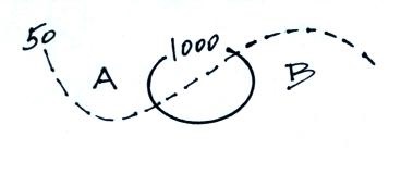
Surface weather maps (20 pts).  Isobars and isotherms (one of each is shown in the figure below). Small horizontal differences in pressure cause the wind to blow. Air motions around high and low pressure centers (northern hemisphere).  Does the figure below show a center of  high or low pressure.  Would you expect the air at Pt. A to be warmer or colder than at Pt. B?


Convergence and divergence.  Rising air motions, what can cause air to rise and why rising air is important.  Sinking air.  Strong and weak pressure gradients and their effects.

Fronts (15 pts).  Cross-sectional structure of cold and warm fronts (such as shown below).  Symbols used on surface maps, where is the warm & cold air, what direction are the fronts moving.  Weather changes (temperature, moisture/dew points, winds) that precede and follow passage of warm and cold fronts.  You will not have to locate a front on a surface map like was done in class, though I might draw a front and ask you what type it is.


Upper level charts (EC only).  What is an upper level chart, how do they differ from surface maps?  You should be able to identify ridges and troughs, know where the warmest and coldest air would be found and should know something about how the winds blow on upper level charts.

Sample Questions
Practice Quiz: 2, 10, 11     Quiz #1: 7, 8, 9, 11     Final Exam: 7, 10a&d, 34, 47


Reviews

Mon., Feb. 17
4:30 - 5:30 pm
Haury (Anthropology) 129
Tue., Feb. 18
4:00 - 5:00 pm
Haury (Anthropology) 129