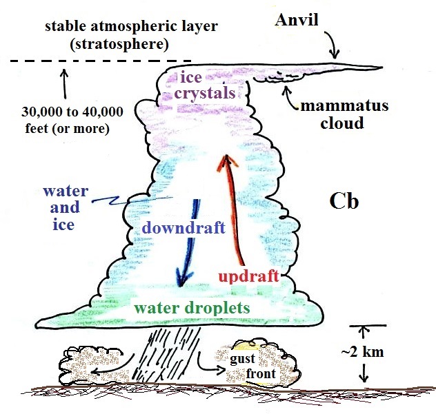
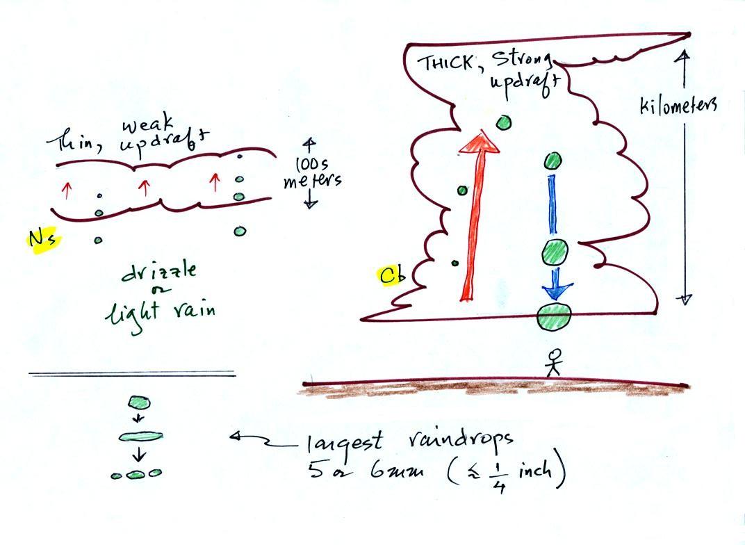
Thursday, Oct. 31, 2019

A short tutorial and some music in recognition of this Sunday's 30th Annual All Souls Procession and Grand Finale in downtown Tucson ( https://allsoulsprocession.org/ )
Classic Sugar Skull Makeup Tutorial 2014 (8:00), La Santa Cecilia "Calaverita" (4:03), Rupa and the April Fishes "Este Mundo" (3:18), "Viene La Muerte Cantado/El corrido de la muerte" (3:16)


We'll use page 97b, page 98a, page 101a, page 101b, and page 102a in class today.  I'll probably also bring along page 102b, page 103a, page 103b, and page 104a.  We probably won't be using this second group until next Tuesday. 

The 1S1P Fog in Tucson reports were collected today.  I hope to have them graded by next Tuesday. 
The 1S1P Controls of Temperature reports are due next Tuesday.

The Experiment #3 reports and Experiment #2 reports (for students working on the Expt. #3 schedule) are due next Tuesday. 

The revised Expt. #2 reports are also due next Tuesday.  Please return your original report with your revised report.  You don't need to do a revision if you're happy with the grade you received on your original report.

The Humidity Optional Assignment from last Thursday has been graded.  Here are answers to the questions on that assignment.

Quiz #3 is one week from today (Thu., Nov. 7).  The Quiz #3 Study Guide is now available.


We need to finish up the section on identifying and naming clouds

 Low altitude clouds


Pretty common.  This cloud name is a little unusual because the two key words for cloud appearance have been combined, but that's a good description of this cloud type - a "lumpy layer cloud".  Remember there isn't a key word for low altitude clouds.


Because they are closer to the ground, the separate patches of Sc are bigger, about fist size (sources of these images:left photo, right photo ).  The patches of Ac, remember, were about thumb nail size..  If the cloud fragments in the photo at right are clearly separate from each other (and you would need to be underneath the clouds so that you could look to make this determination) these clouds would probably be "fair weather" cumulus.  If the patches of cloud are touching each other (clearly the case in the left photo) then stratocumulus would be the correct designation.


No photographs of stratus clouds, sorry.  Other than being closer to the ground they really aren't much different from altostratus or nimbostratus.


Cumulus clouds come with different degrees of vertical development.  The fair weather cumulus clouds don't grow much vertically at all.  A cumulus congestus cloud is an intermediate stage between fair weather cumulus and a thunderstorm.


Photographs of "fair weather" cumulus on the left (source) and cumulus congestus or towering cumulus on the right (source)


Thunderstorms

There 
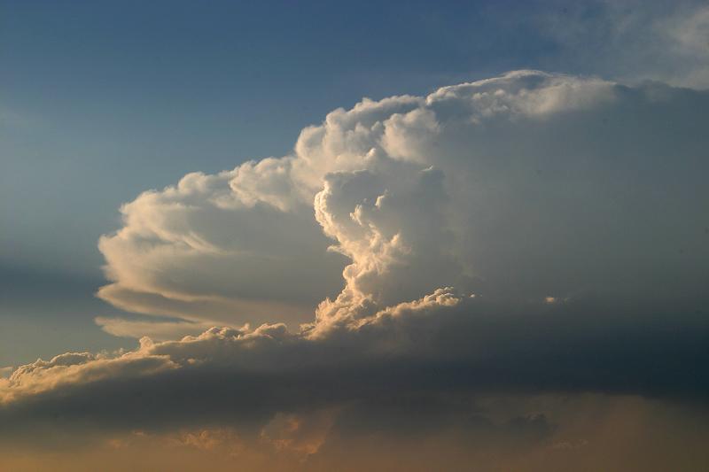
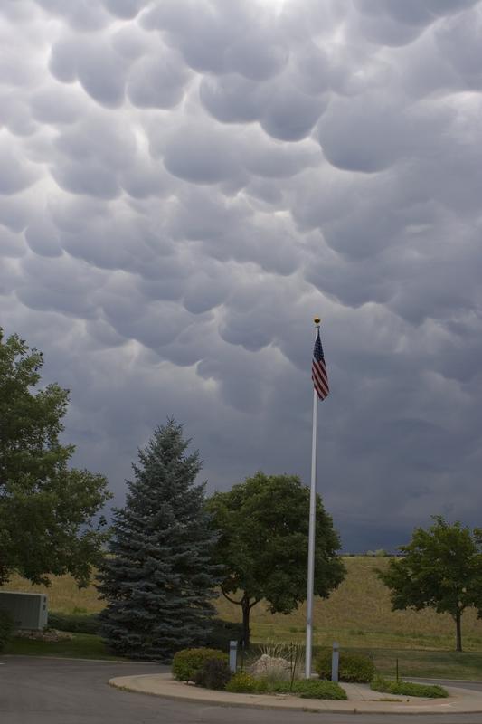
are lots of distinctive features on cumulonimbus clouds including the flat anvil top and the lumpy mammatus clouds sometimes found on the underside of the anvil. 
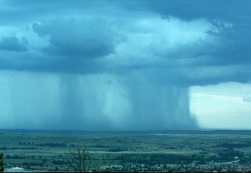
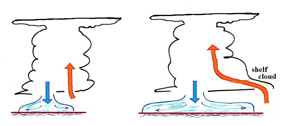
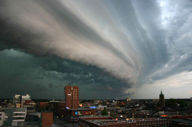
Cold dense downdraft winds hit the ground below a thunderstorm and spread out horizontally underneath the cloud.  The leading edge of these winds produces a gust front (in Arizona dust front might be a little more descriptive and easier to remember).  Winds at the ground below a thunderstorm can exceed 100 MPH, stronger than many tornadoes.

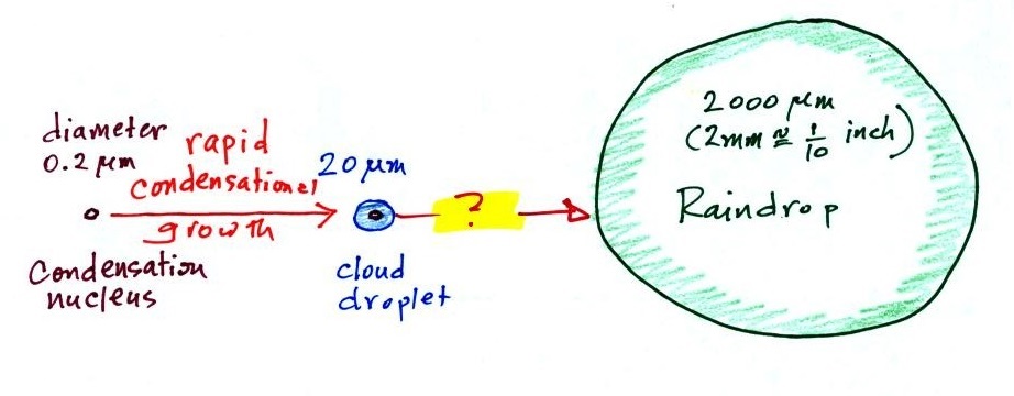
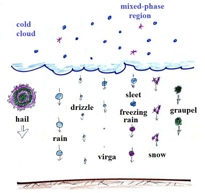
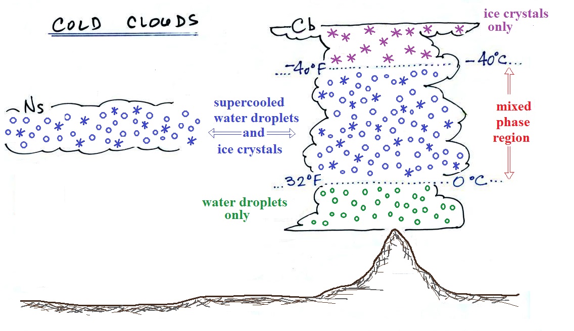
The top of a thunderstorm (violet in the sketch) is cold enough that it will be composed of just ice crystals.  The bottom (green) is composed of water droplets.  In the middle of the cloud (blue) both water droplets and ice crystals exist 
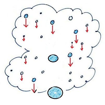
together at temperatures below freezing (the water droplets have a hard time freezing).  Water and ice can also be found together in nimbostratus clouds.  We will see that this mixed phase region of the cloud is important for precipitation formation.  It is also where the electricity that produces lightning is generated.


The top left photo shows a thunderstorm viewed from the space station (source: NASA Earth Observatory).  The flat anvil top is the dominant feature.  The remaining three photographs are from the UCAR Digital Image Library.  The bottom left photograph shows heavy by localized rain falling from a thunderstorm.  At bottom right is a photograph of mammatus clouds found on the underside of the flat anvil cloud.


Cold air spilling out of the base of a thunderstorm is just beginning to move outward from the bottom center of
the storm in the picture at left.  In the picture at right the cold air has moved further outward and has begun to get in the way of the updraft.  The updraft is forced to rise earlier and a little ways away from the center of the thunderstorm.  Note how this rising air has formed an extra lip of cloud.  This is called a shelf cloud. 


Here's a photograph of the dust stirred up by the thunderstorm downdraft winds (blowing into Ahwatukee, Pheonix on Aug. 22, 2003).  The thunderstorm would be off the left somewhere and the dust front would be moving toward the right.  Dust storms like this are often called "haboobs" (source of this image)We'll learn more about the hazards associated with strong downdraft winds later in the semester when we cover thunderstorms.


Shelf clouds can sometimes be quite impressive (the picture above is from a Wikipedia article on arcus clouds).  The main part of the thunderstorm would be to the left.  Cold air is moving from left to right in this picture.  The shelf cloud forms along the advancing edge of the gust front (in many ways it is like a cold front)


You should end up with something like this at the end of class.  Your cloud chart will also include some words of description or clues that help you identify and name a cloud.  I've used abbreviations for the cloud names (Cc = cirrocumulus, As = altostratus etc).

Here's a link to a cloud chart on a National Weather Service webpage with actual photographs.
  27 clouds are shown.  This is because most of the 10 main cloud types have subtle variations and sub groups.


Formation of precipitation in clouds

Only two of the 10 main cloud types (nimbostratus and cumulonimbus) are able to produce significant amounts of precipitation and produce precipitation that can survive the fall from cloud to ground without evaporating.  Why is that? 

Before we get into the details you will notice that significant amounts is underlined in the sentence above.  That is because you will sometimes see streamers of precipitation falling from some of the other cloud types, clouds that you would not have thought capable of producing precipitation.   A couple of examples are shown below


Streamers of snow falling from either mid or high altitude clouds at sunset.  (source of this image)
Snow falling from high altitude cirrus uncinus clouds, photographed in Catalina, Arizona, I believe.  (source of this image)


Precipitation like the examples above will almost always evaporate (or sublime) before reaching the ground.  If the clouds are closer to the ground a few of the drops of rain or drizzle or flakes of snow might survive the fall to the ground, but it would be very light - probably not even enough to dampen the ground.  So largely it is a question of quickly growing a precipitation particle of sufficient size as to be able to survive the fall from cloud to ground without evaporating away.

Only 2 of the 10 cloud types are able to produce significant amounts of precipitation.
Why is it so hard for clouds to make precipitation?

This figure shows typical sizes of cloud condensation nuclei (CCN), cloud droplets, and raindrops (a human hair is about 50 μm thick for comparison).  As we saw in the cloud in a bottle demonstration it is relatively easy to make cloud droplets.  You cool moist air to the dew point and raise the RH to 100%.  Water vapor condenses pretty much instantaneously onto cloud condensation nuclei to form cloud droplets.  It would take much longer (a day or more) for condensation to turn a cloud droplet into a raindrop.  You know from personal experience that once a cloud forms you don't have to wait that long for precipitation to begin to fall.

Part of the problem is that it takes quite a bit more water to make a 2000 μm diameter raindrop than it does to make 20 μm diameter cloud droplets .  A raindrop is about 100 times bigger across than a cloud droplet.  How many droplets are needed to make a raindrop?  Before answering that question we will look at a cube (rather than a sphere).


How many sugar cubes would you need to make a box that is 4 sugar cubes on a side?


It would take 16 sugar cubes to make each layer and there are 4 layers.  So you'd need 64 sugar cubes.  The key point is that we are dealing with volumes,  in the case of a cube, volume is length x width x height.

The raindrop is 100 times wider, 100 times bigger from front to back, and 100 times taller than the cloud droplet.  The raindrop has a volume that is 100 x 100 x 100 = 1,000,000 (one million) times larger than the volume of the cloud droplets. 
It takes about a million cloud droplets to make one average size raindrop.


Precipitation-producing processes
Fortunately there are two processes capable of quickly turning small cloud droplets into much larger precipitation particles in a cloud.


The collision coalescence process works in clouds that are composed of water droplets only.  This is often called the "warm rain" process.  Clouds like this are found in the tropics (and very occasionally in the summer in Tucson).  We'll see that this is a pretty easy process to understand. 


This process will only produce rain, drizzle, and something called virga (rain that evaporates before reaching the ground).  Because the clouds are warm and warm air can potentially contain more water vapor than cooler air, the collision-coalescence process can produce very large amounts of rain.

The ice crystal process produces precipitation everywhere else.  This is the process that normally makes rain in Tucson, even on the hottest day in the summer (summer thunderstorm clouds are tall and grow into cold, below freezing, parts of the atmosphere).  Hail and graupel often fall from these summer storms; proof that the precipitation started out as an ice particle).  Thunderstorms also produce lightning and later in the semester we will find that ice is needed to make the electrical charge that leads to lightning


There is one part of ice-crystal process that is a little harder to understand, but look at the variety of different kinds of precipitation particles (rain, snow, hail, sleet, graupel, etc) that can result.

The Collision-Coalescence process

The collision coalescence process works in clouds that are composed of water droplets only.  Here's how it works.  The picture (found on page 101b in the ClassNotes) below shows what you might see if you looked inside a warm cloud with just water droplets:


The collision coalescence process works in a cloud filled with cloud droplets of different sizes, that's critical.  The larger droplets fall faster than the small droplets.  A larger-than-average cloud droplet will overtake and collide with smaller slower moving ones.


The bigger droplets fall faster than the slower ones.  They collide and stick together (coalesce).  The big drops gets even bigger, fall faster, and collide more often with the smaller droplets.  This is an accelerating growth process - think of a growing ball of snow as it rolls down a snow-covered hill and picks up snow, grows, and starts to roll faster and faster;  or think of an avalanche that gets bigger and moves faster as it travels downslope.


image source

source of this image


Very quickly a larger than average cloud droplet can grow to raindrop size.


The figure shows the two precipitation producing clouds: nimbostratus (Ns) and cumulonimbus (Cb).  Ns clouds are thinner and have weaker updrafts than Cb clouds.  The largest raindrops fall from Cb clouds because the droplets spend more time in the cloud growing. In a Cb cloud raindrops can grow while being carried upward by the updraft (in this case the smaller droplets are catching and colliding with the larger droplets, but the end result is the same) and also when falling in the downdraft.

Raindrops grow up to about 1/4 inch in diameter.  When drops get larger than that, wind resistance flattens out the drop as it falls toward the ground.  The drop quicly breaks apart into several smaller droplets.  Solid precipitation particles such as hail can get much larger (an inch or two or three in diameter).

And actually my sketch at lower left above isn't quite accurate as this video of the breakup of a 5 mm diameter drop of water shows.


The ice crystal process works in most locations most of the time.  Before we can look at how the ice crystal process actually works we need to learn a little bit about clouds that contain ice crystals - cold clouds.

Cold clouds
The figure below shows the interior of a cold cloud (see page 102a in the ClassNotes)


The bottom of the thunderstorm, Point 1, is warm enough (warmer than freezing) to just contain water droplets.  The top of the thunderstorm, Point 2, is colder than -40 F (which, coincidentally, is equal to -40 C) and just contains ice crystals.  The interesting part of the thunderstorm and the nimbostratus cloud is the middle part, Point 3, that contains both supercooled water droplets (water that has been cooled to below freezing but hasn't frozen) and ice crystals.  This is called the mixed phase region.  This is where the ice crystal process will be able to produce precipitation.  This is also where the electrical charge that results in lightning is created.

I'm not sure we'll have time for this next small section in class today.  But I'll leave it here and also probably include it at the start of the Tue., Nov. 5 notes.

Ice crystal nuclei


The supercooled water droplets in cold clouds aren't able to freeze even though they have been cooled below freezing.  This is because it is much easier for small droplets of water to freeze onto an ice crystal nucleus (just like it is easier for water vapor to condense onto condensation nuclei rather than condensing and forming a small droplet of pure water).  Not just any material will work as an ice nucleus however.  The material must have a crystalline structure that is like that of ice.  There just aren't very many materials with this property and as a result ice crystal nuclei are rather scarce.  In much of the mixed phase region there are more supercooled water droplets than ice crystals.