Wednesday, Mar. 20, 2019
We'll use page 93,
page 95, and page 96 from the ClassNotes
today.
Making a cloud in a bottle
Cooling air & increasing relative humidity, condensation
nuclei, and scattering of light
are all involved in this demonstration.
We used a
strong, thick-walled, 4 liter vacuum flask (designed
to not implode when all of the air is pumped out of
them, they really aren't designed to be
pressurized). There was a little water in the
bottom of the flask to moisten the air in the
flask. Next we pressurized the air in the
flask with a bicycle pump. At some point the
pressure blows the cork out of the top of the
flask. The air in the flask expands outward
and cools. This sudden cooling increases the
relative humidity of the moist air in the flask to
more than 100% momentarily and water vapor condenses
onto cloud condensation nuclei in the air.
I like it best when a faint, hard to see, cloud
becomes visible. That's because there is
something we can add to the demonstration that will
make the cloud much "thicker" and easier to see.

The demonstration was repeated an additional
time with one small change. A burning match was dropped
into the bottle. The smoke from the matches added lots of
very small particles, condensation nuclei, to the air in the
flask (you could see the swirls of smoke, the small particles
scattered light). The same amount of water vapor was
available for cloud formation but the cloud that formed this
time was quite a bit "thicker" and much easier to see. To
be honest the burning match probably also added a little water
vapor (water vapor together with carbon dioxide is one of the by
products of combustion).
I have found a couple of online versions of the
demonstration. The first
is performed by Bill Nye "The Science Guy" and is pretty similar
to the one done in class. The second
differs only in the way that is used to caused the sudden
expansion and cooling of the air (I didn't care much for the
music (probably your opinion of the music I play before class)
and I would recommend turning down the sound while watching the
video).
Mother Nature's version of the Cloud in a Bottle
demonstration
A
brush fire in this picture is heating up air and causing
it to rise. Combustion also adds some moisture and
lots of smoke particles to the air. You can see
that initially the rising air doesn't form a cloud (the
RH is still less than 100%). A little higher and
once the rising air has cooled enough (to the dew point)
a cloud does form. And notice the cloud's
appearance - puffy and not a layer cloud. Cumulo
or cumulus is the word used to describe a cloud with
this appearance. These kinds of fire caused clouds
are called pyrocumulus clouds. The example above
is from a
Wikipedia article fire-caused clouds.
The fire in this case was
the "Station Fire" burning near Los Angeles in August
2009. We sometimes see clouds like this in the summer
when lightning starts a fire burning in one of the nearby
forests. The pyrocumulus cloud caused by the fire is
sometimes the only cloud in the sky.
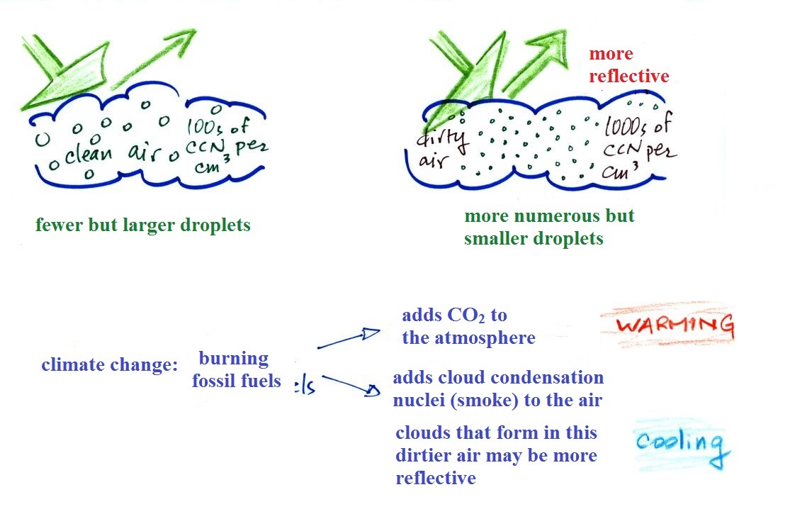
Clouds and climate change
This effect has some implications for climate change.
A cloud that forms in dirty air is composed of a large number
of small droplets (right figure above). This cloud is more
reflective than a cloud that forms in clean air, that is composed
of a smaller number of larger droplets (left figure).
Combustion of fossil fuels adds carbon dioxide to the
atmosphere. There is concern that increasing carbon
dioxide concentrations (and other greenhouse gases) will enhance
the greenhouse effect and cause global warming. Combustion
also adds condensation nuclei to the atmosphere (just like the
burning match added smoke to the air in the flask). More
condensation nuclei might make it easier for clouds to form,
might make the clouds more reflective, and might cause
cooling. There is still quite a bit of uncertainty about
how clouds might change and how this might affect climate.
Remember that clouds are good absorbers of IR radiation and also
emit IR radiation.
Clouds are one of the best ways of cleaning the
atmosphere. This is something we mentioned earlier in the
semester and you're now in a position to understand it better.

A cloud is composed of small
water droplets (diameters of 10 or 20 micrometers) that form on
particles ( diameters of perhaps 0.1 or 0.2 micrometers). The
droplets "clump" together to form a raindrop (diameters of 1000
or 2000 micrometers which is 1 or 2 millimeters), and the
raindrop carries the particles to the ground. A typical
raindrop can contain 1 million cloud droplets so a single
raindrop can remove a lot of particles from the air. You
may have noticed how clear the air seems the day after a
rainstorm; distant mountains are crystal clear and the sky has a
deep blue color. Gaseous pollutants can dissolve in the
water droplets and be carried to the ground by rainfall
also. We'll be looking at the formation of precipitation
in more detail later this week.
We should be able to get well into
this next topic in class on Tuesday. You'll find the
following on page
95 in the ClassNotes.
Identifying and naming clouds - 10 main cloud
types

I'm hoping you'll try to learn
these 10 cloud names. There is a smart and a
not-so-smart way of learning these names. The
not-so-smart way is to just memorize them.
Because they all sound alike you will inevitably get
them mixed up. That gets to be a lot
of material to try to just memorize.
A better way is to
recognize that all the cloud names are made up of a few
key words. In addition to
learning the names, I'm hoping you'll be able to
sketch each of the clouds and describe them in
words. The key words will help with that also.
***
Clouds are classified using just two criteria:
altitude and appearance ***
There are 2 key words that tell you something about the
cloud's altitude and 2 more for cloud appearance
(there's a 5th key word for clouds that are producing
precipitation). My recommendation is to learn the
key words and what they mean.
Then you can usually construct a cloud name by taking key
words from both the altitude and appearance groups and
combining them.
Cloud Altitude
Clouds are grouped into one of three altitude
categories: high, middle level, and low. It is very hard to just look up
in the sky and determine a cloud's altitude (that's
why the 2 to 5km and 5 to 10 km altitude ranges are
X'd out). You will need to look for other clues
to distinguish between
high and middle altitude clouds. We'll learn
about some of the clues when we look at cloud
pictures.
Cirrus
or cirro
identifies a high altitude cloud. There are three
types of clouds found in the high altitude category..
Alto
in a cloud name means the cloud is found at
middle altitude. The arrow connecting altostratus
and nimbostratus indicates that they are basically the
same kind of cloud. When an altostratus cloud
begins to produce rain or snow its name is changed to
nimbostratus. A nimbostratus cloud may become
somewhat thicker and lower than an altostratus
cloud. Sometimes it might sneak into the low
altitude category.
There is no key word for low altitude clouds. Low
altitude clouds have bases that form 2 km or less above
the ground. The summit of Mt. Lemmon in the Santa Catalina mountains
north of Tucson is about 2 km above the valley
floor. Low altitude clouds
will have bases that form at or below the summit of Mt. Lemmon.
Examples of puffy
patchy (cumuliform) clouds found at different
altitudes
 |
high altitude cloud
the patches of cloud are small because they are far
away.
This is a cirrocumulus cloud,
cirro means high altitude, cumulus means "patchy".
The air is cold at high altitude and doesn't contain
much water vapor. High altitude clouds are thin,
there's not much raw material available to make the
cloud. |
 |
middle altitude cloud
the patches of cloud are bigger because they closer to
the ground.
This is an altocumulus cloud.
|
 |
low altitude cloud
cumulus
clouds
(there is no key word for low altitude) |
Cloud Appearance

Cumulus clouds are often described
as resembling a head of cauliflower. Clouds can have
a patchy of puffy (or lumpy, wavy, splotchy or ripply)
appearance. These are cumuliform clouds and will
have cumulo
or cumulus in their name. These
clouds are as tall or taller than they are across, in an
unstable atmosphere cumuliform clouds will grow vertically
and turn into thunderstorms. Strong thunderstorms
can produce dangerous weather.
Here
are some examples of the different textures or features that
characterize cumuliform clouds:
|
|

Head of cauliflower
source
|
|
|
|
ripples or waves
note the size, this is probably a middle or low
level cloud
source
|
This is probably a
middle or high level cloud because the ripples are
smaller (higher and further away)
source
|
Stratiform clouds grow
horizontally and form layers. They form when the
atmosphere is stable.
You'll find strato or stratus in the cloud
name. Stratiform
- as in rock strata, or stratosphere.
rock strata at the
Grand Canyon
source
|

A side view of a layer cloud. How much
sunlight is able to shine through the cloud depends on
how thick the cloud is (and a clue about the cloud's
altitude). A person on the ground may or may not
cast a shadow.
|

A view from the ground looking up
at the sun through a middle level layer cloud.
The sun is visible but blurred. (source)
|
Cloud appearance comparison
You'll become more familiar with different
types of cloud appearances by looking at clouds and
cloud photographs.
 |
 |
|
featureless Stratiform
cloud
(layer cloud)
an altostratus cloud
|
an
in-between case,
a "lumpy layer cloud"
this is named stratocumulus
|
patchy, puffy
Cumuliform cloud
cumulus
clouds
|

|
cirriform is sometimes used
as an appearance key word
a cirrus
cloud
source
of this image
|
Note the stratocumulus cloud name is formed by combining the
two key words for appearance which is a little unusual.
Trying to draw the different clouds will help you to
visualize the differences in appearance.
To draw the cirriform cloud you could use the sharp end of a
pencil. Using the side of a pencil as you would if you
were shading in or coloring in a picture was used in the center
picture. To make the right picture I put a bunch of ink on
the side of a sponge and pressed it against the paper.
There's a 5th key word that I have been neglecting to
mention.
Nimbo or
nimbus, means precipitation (it is also the name of a local brewing company).
Only two of the 10 cloud types are able to produce
(significant amounts of) precipitation. It's not as
easy as you might think to make precipitation. We'll
start to look at precipitation producing processes in the
next class.
Nimbostratus clouds tend to
produce fairly light precipitation over a large area.
Cumulonimbus clouds produce heavy showers over more localized
areas. Thunderstorm clouds can also produce hail,
lightning, and tornadoes. Hail would never fall from a Ns cloud.
While you are still learning the cloud names you might put the
correct key words together in the wrong order (stratonimbus instead of nimbostratus,
for example). You won't be penalized for those kinds of
errors in this class because you are putting together the
right two key words.
No penalty for putting the key words together
in the wrong order