Tuesday, Oct. 31, 2017
Black Prairie "Let It Out"
(3:14), "Song
Remains the Same" (5:42), "Taraffa"
(4:34), "Nowhere
Massachusetts" (3:32), "How Do You
Ruin Me" (3:47), "Little Song
Bird" (4:10)
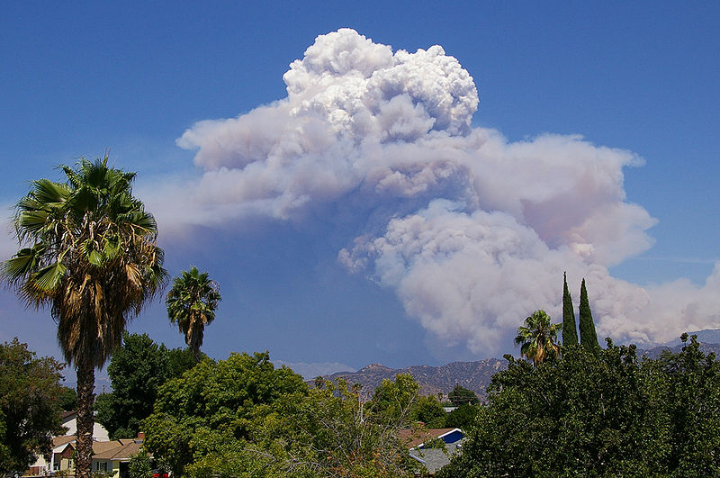
Mother Nature's version of the Cloud in a Bottle
demonstration
A
brush fire in this picture is heating up air and causing
it to rise. Combustion also adds some moisture and
lots of smoke particles to the air. You can see that
initially the rising air doesn't form a cloud (the RH is
still less than 100%). A little higher and once the
rising air has cooled enough (to the dew point) a cloud
does form. And notice the cloud's appearance - puffy
and not a layer cloud. Cumulo or cumulus is the word
used to describe a cloud with this appearance. These
kinds of fire caused clouds are called pyrocumulus
clouds. The example above is from a
Wikipedia article fire-caused clouds.
The fire in this case was the
"Station Fire" burning near Los Angeles in August 2009.
We sometimes see clouds like this in the summer when lightning
starts a fire burning in one of the nearby forests. The
pyrocumulus cloud caused by the fire is sometimes the only
cloud in the sky.
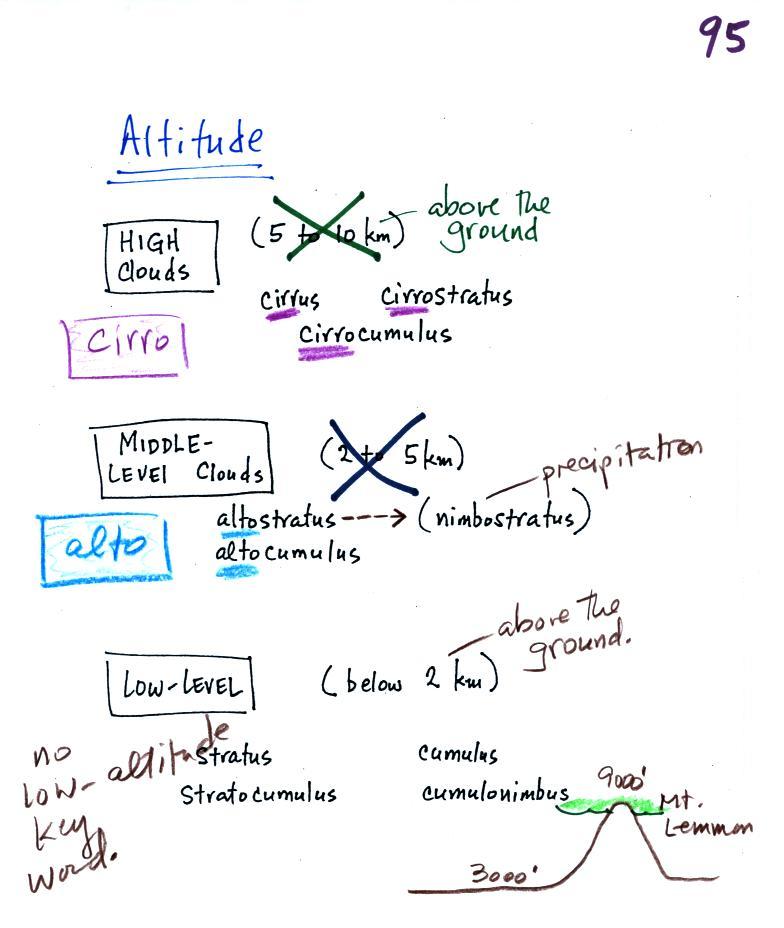
Identifying and naming clouds - 10 main cloud
types
We'll spent the entire class learning to identify and name
clouds.
I'm hoping you'll try to learn
these 10 cloud names. There is a smart and a
not-so-smart way of learning these names. The
not-so-smart way is to just memorize them. Because
they all sound alike you will inevitably get them mixed
up. In addition to learning the names, I'm hoping
you'll be able to sketch each of the clouds and describe
them in words. That gets to be a lot of material
to try to just memorize.
A better way is to recognize
that all the cloud names are made up of a few key
words.
***
Clouds are classified using just two criteria:
altitude and appearance ***
There are 2 key words that tell you something about the
cloud's altitude and 2 more for cloud appearance (there's
a 5th key word for clouds that are producing
precipitation). My recommendation is to learn the
key words and what they mean. Then
you can usually construct a cloud name by taking key words
from both the altitude and appearance groups and combining
them.
Cloud Altitude
Clouds are grouped into one of three altitude
categories: high, middle level, and low. It is very hard to just look up in
the sky and determine a cloud's altitude. You will
need to look for other clues to distinguish
between high and middle altitude clouds. We'll
learn about some of the clues when we look at cloud
pictures.
Cirrus
or cirro
identifies a high altitude cloud. There are three
types of clouds found in the high altitude category..
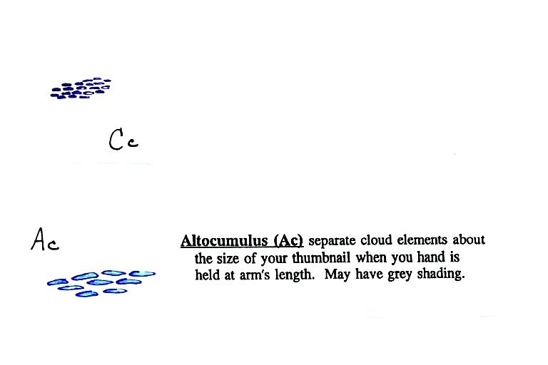
Alto
in a cloud name means the cloud is found at middle
altitude. The arrow connecting altostratus and
nimbostratus indicates that they are basically the same
kind of cloud. When an altostratus cloud begins to
produce rain or snow its name is changed to
nimbostratus. A nimbostratus cloud may become
somewhat thicker and lower than an altostratus
cloud. Sometimes it might sneak into the low
altitude category.
There is no key word for low altitude clouds. Low
altitude clouds have bases that form 2 km or less above
the ground. The summit of Mt. Lemmon in the Santa Catalina mountains
north of Tucson is about 2 km above the valley
floor. Low altitude clouds will
have bases that form at or below the summit of Mt. Lemmon.
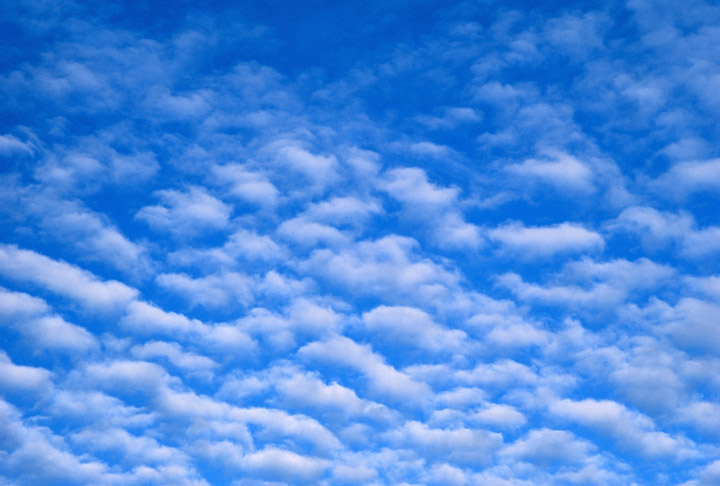
Examples of puffy
patchy (cumuliform) clouds found at different
altitudes
 |
high altitude cloud
the patches of cloud are small because they are far
away.
This is a cirrocumulus cloud,
cirro means high altitude, cumulus means "patchy".
The air is cold at high altitude and doesn't contain much
water vapor. High altitude clouds are thin, there's
not much raw material available to make the cloud. |
 |
middle altitude cloud
the patches of cloud are bigger because they closer to the
ground.
This is an altocumulus cloud.
|
 |
low altitude cloud
cumulus
clouds
(there is no key word for low altitude) |
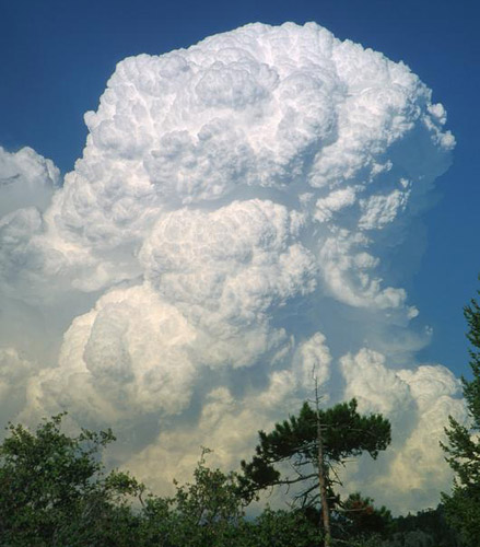
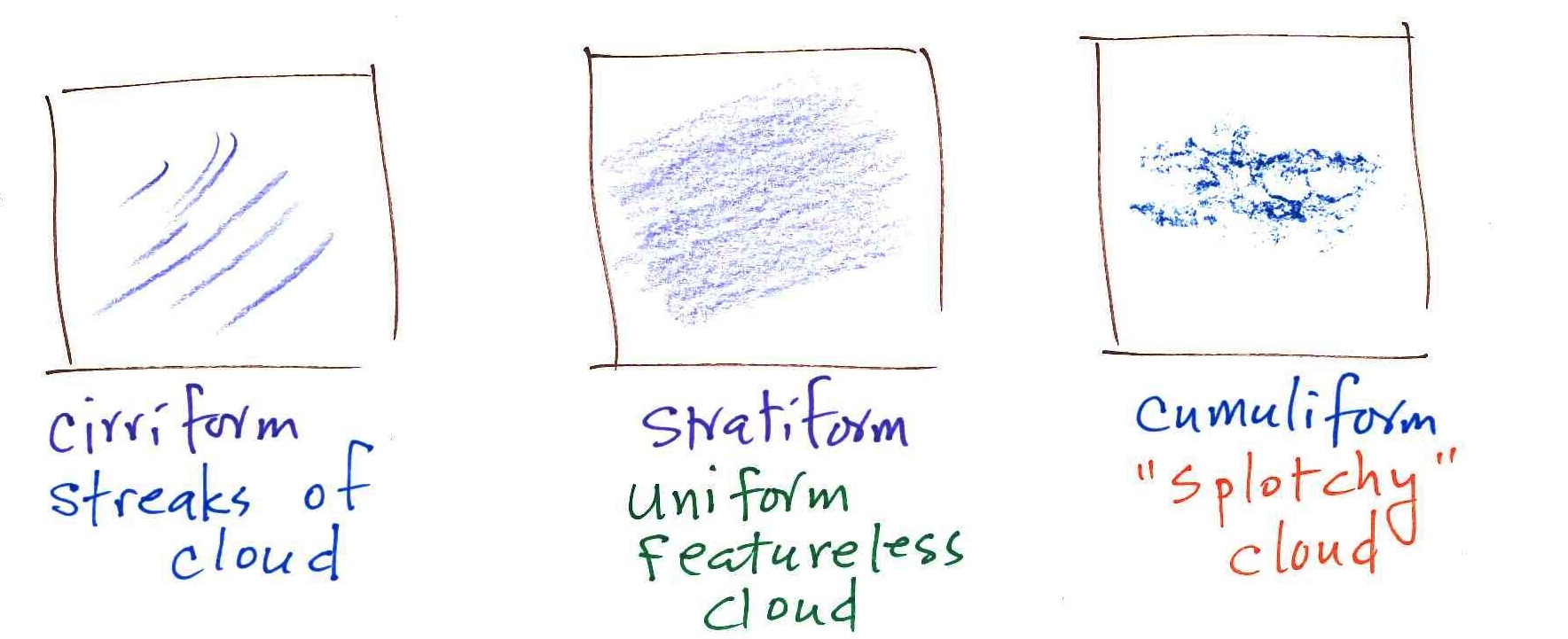
Cloud Appearance

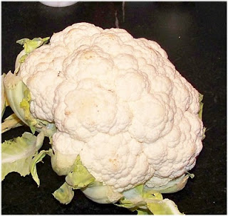
Cumulus clouds are often described as resembling a
head of cauliflower. Clouds can have a patchy of puffy
(or lumpy, wavy, splotchy or ripply) appearance. These
are cumuliform clouds and will have cumulo or
cumulus in their name. These clouds are
as tall or taller than they are across, in an unstable
atmosphere cumuliform clouds will grow vertically and turn
into thunderstorms. Strong thunderstorms can produce
dangerous weather.
Here
are some examples of the different textures or features that
characterize cumuliform clouds:
|
|
Head of cauliflower
source
|
|
|
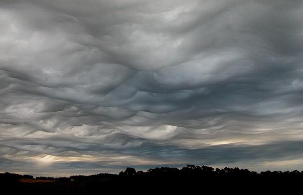
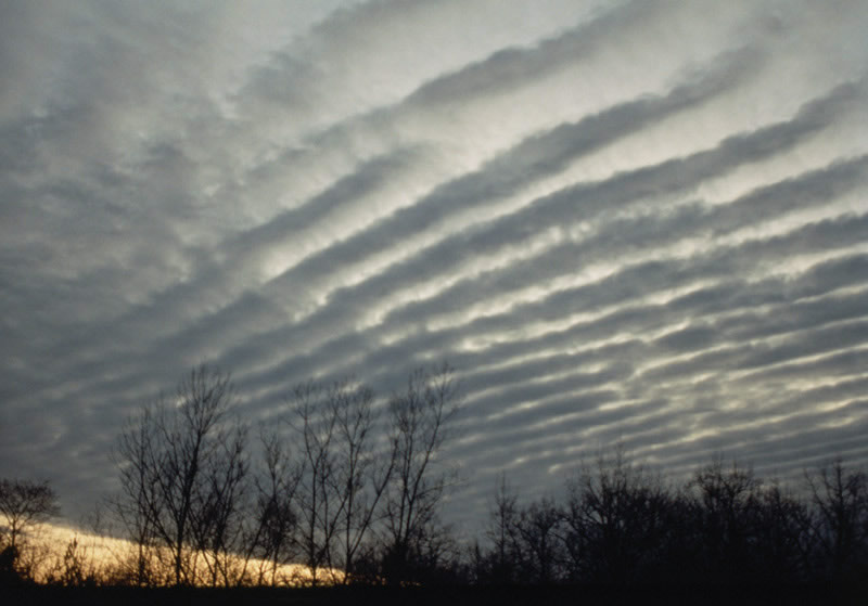
|
ripples or waves
note the size, this is probably a middle or low level
cloud
source
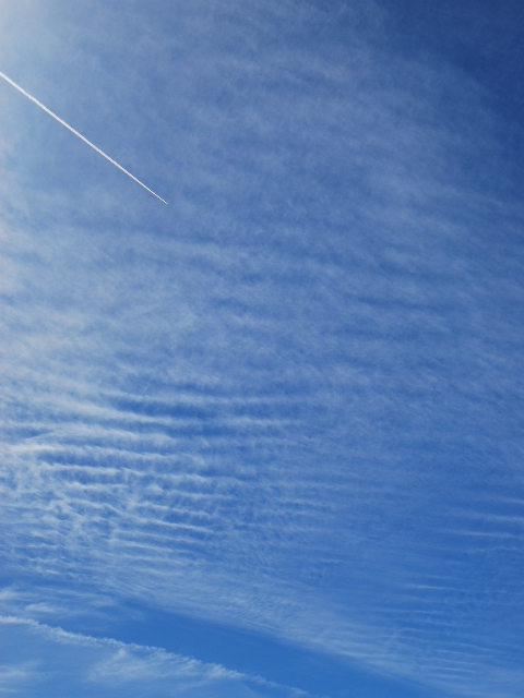
|
This is probably a
middle or high level cloud because the ripples are
smaller (higher and further away)
source
|
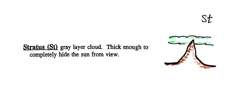
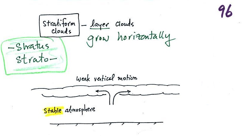
Stratiform clouds grow
horizontally and form layers. They form when the
atmosphere is stable.
You'll find strato or stratus in the cloud
name. Stratiform
- as in rock strata, or stratosphere.
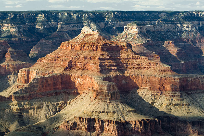
rock strata at the
Grand Canyon
source
|
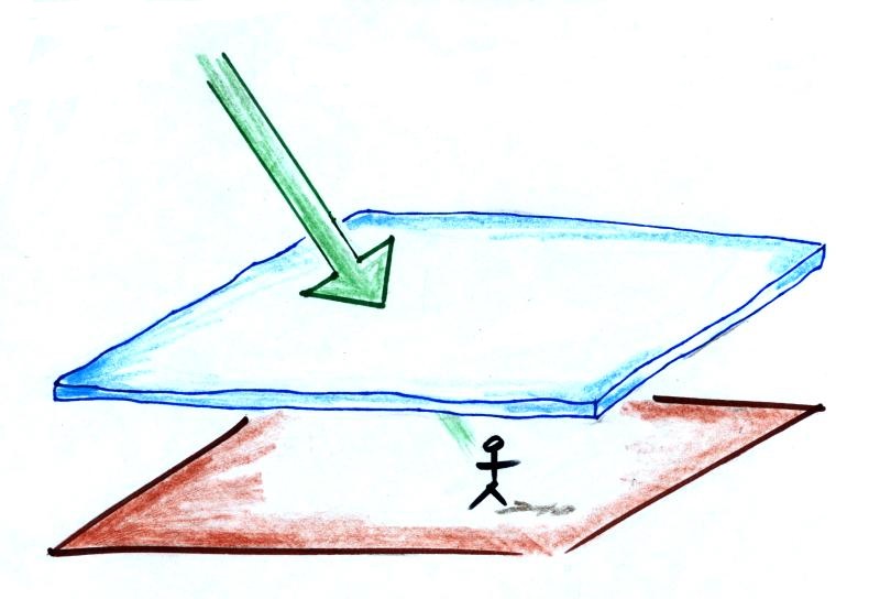
A side view of a layer cloud. How much
sunlight is able to shine through the cloud depends on how
thick the cloud is (and a clue about the cloud's
altitude). A person on the ground may or may not
cast a shadow.
|
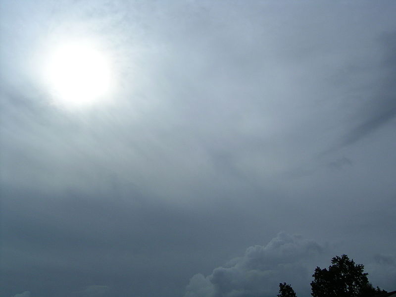
A view from the ground looking up
at the sun through a middle level layer cloud. The
sun is visible but blurred. (source)
|
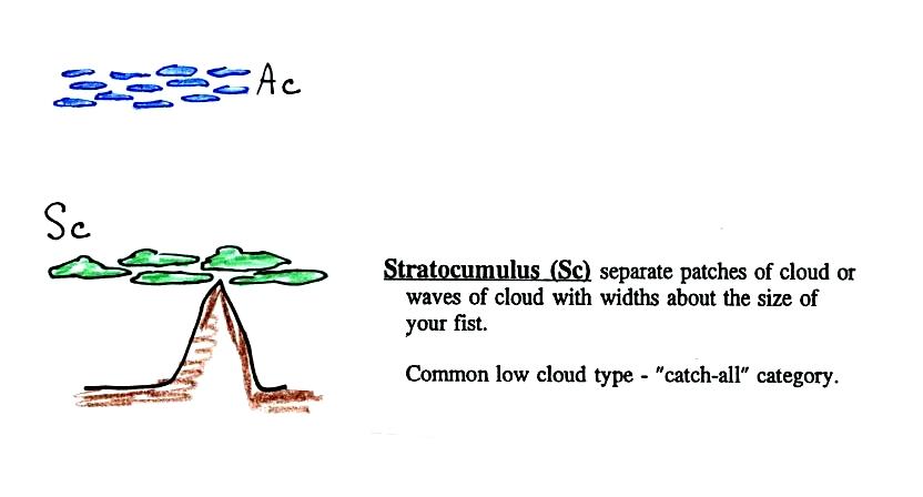
Cloud appearance comparison
You'll become more familiar with different types
of cloud appearances by looking at clouds and cloud
photographs.
 |
 |
|
featureless Stratiform
cloud
(layer cloud)
an altostratus cloud
|
an in between
case,
a "lumpy layer cloud"
this is named stratocumulus
|
patchy, puffy Cumuliform
cloud
cumulus
clouds
|
|
cirriform is sometimes used
as an appearance key word
a cirrus
cloud
source
of this image
|
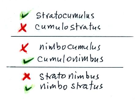
Note the stratocumulus cloud name is formed by combining the
two key words for appearance which is a little unusual.
Trying to draw the different clouds will help you to visualize
the differences in appearance.
To draw the cirriform cloud you could use the sharp end of a
pencil. Using the side of a pencil as you would if you were
shading in or coloring in a picture was used in the center
picture. To make the right picture I put a bunch of ink on
the side of a sponge and pressed it against the paper.
There's a 5th key word that I have been neglecting to
mention.
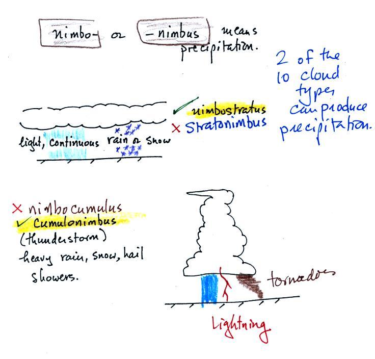
Nimbo or
nimbus, means precipitation (it is also the name of a local brewing company).
Only two of the 10 cloud types are able to produce
(significant amounts of) precipitation. It's not as easy
as you might think to make precipitation. We'll start to
look at precipitation producing processes in the next class.
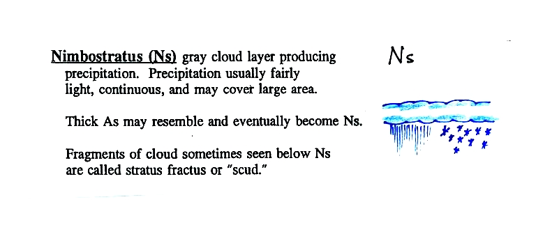
Nimbostratus clouds tend to produce
fairly light precipitation over a large area. Cumulonimbus
clouds produce heavy showers over more localized areas.
Thunderstorm clouds can also produce hail, lightning, and
tornadoes. Hail would never fall from a
Ns cloud.
While you are still learning the cloud names you might put the
correct key words together in the wrong order (stratonimbus instead of nimbostratus,
for example). You won't be penalized for those kinds of
errors in this class because you are putting together the right
two key words.
No penalty for putting the key words together in
the wrong order
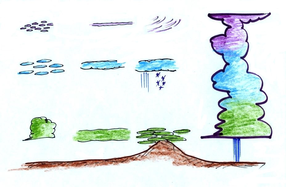
We've covered a fair amount of
information and we're going to be looking at a lot of cloud
pictures. You'll need to organize this material is a
clear compact way. Here's something that may help.
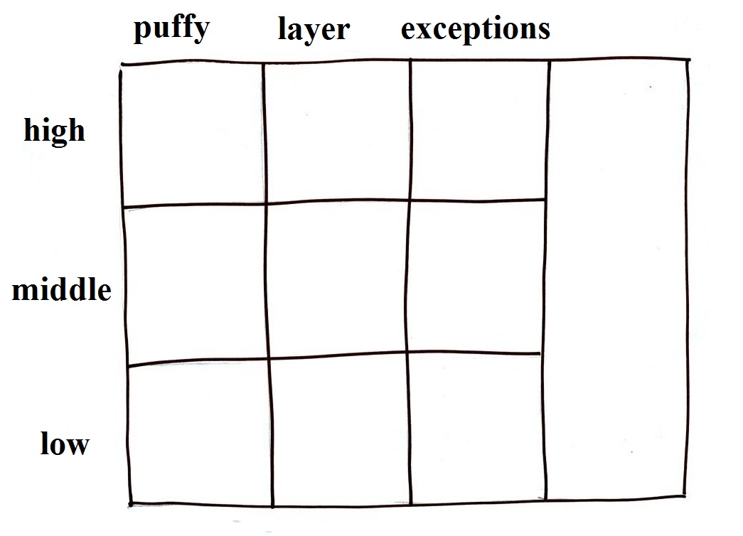
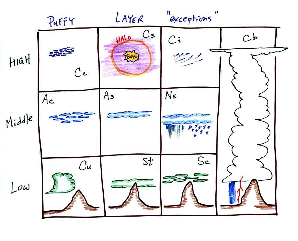
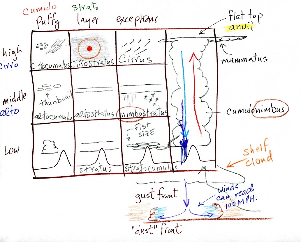
|
|
Take out a blank sheet of paper and draw a chart like shown
above at left. There are 10 boxes, one for each of the cloud
types. The three altitude categories run along the vertical
side of the chart and the two appearance categories run along the
top (note the exceptions column). This will force you to
remember the key words. Then you should be able to put a
name in each box, sketch each of the clouds (as done above at
right), and a short written description of each cloud.
Something that I often forget to mention in class - the
colors used on the clouds at right. Green is indicating
clouds that are warmer than freezing and made up of only water
droplets. Purple or violet indicates very cold high altitude
clouds composed of only ice crystals. The middle level
clouds shaded blue are colder than freezing and contain both
unfrozen water droplets and ice crystals. That's a little
surprising but turns out to be a very important part of
precipitation-producing (and lightning-producing) clouds.
We'll be looking at pictures of most of the 10 main cloud
types today. I'm hoping you'll go outside and have a look at
clouds when and if they're in the sky. But also a warning,
real world examples are often much complex than what we'll be
looking at here. You'll often find many different cloud type
mixed together. One day in ATMO 170 is not going to make you
cloud identification experts.
Try to organize this class notes material as you read through
it. For each of the cloud types sketch the cloud, write down
its name and add a word or two of description on a small index
card size piece of paper. Put that piece of paper in its
proper position on a larger cloud chart. I.e. does that
cloud belong at high, middle or low altitude.
Names, pictures and short descriptions of most of the
10 main cloud types
(many of the descriptions below are found on pps 97 & 98 in
the ClassNotes)
Something I usually don't mention in class. If you
get a particularly good photograph of a cloud or if you are an
artist (as I know some of you must be) and are able to draw some
really nice cloud pictures, I'd like to see them (and include them
in the class notes). So send them in.
High altitude clouds

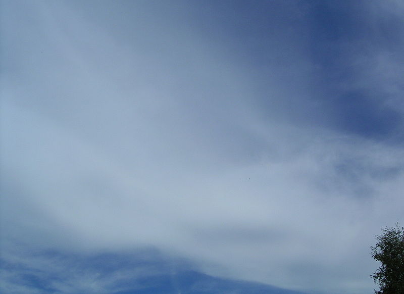
High altitude clouds
are thin because the air at high altitudes is very
cold and cold air can't contain much moisture,
the raw material needed to make clouds (the saturation
mixing ratio for cold air is very small). These clouds are also often blown
around by fast high altitude winds.
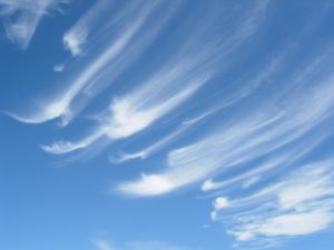
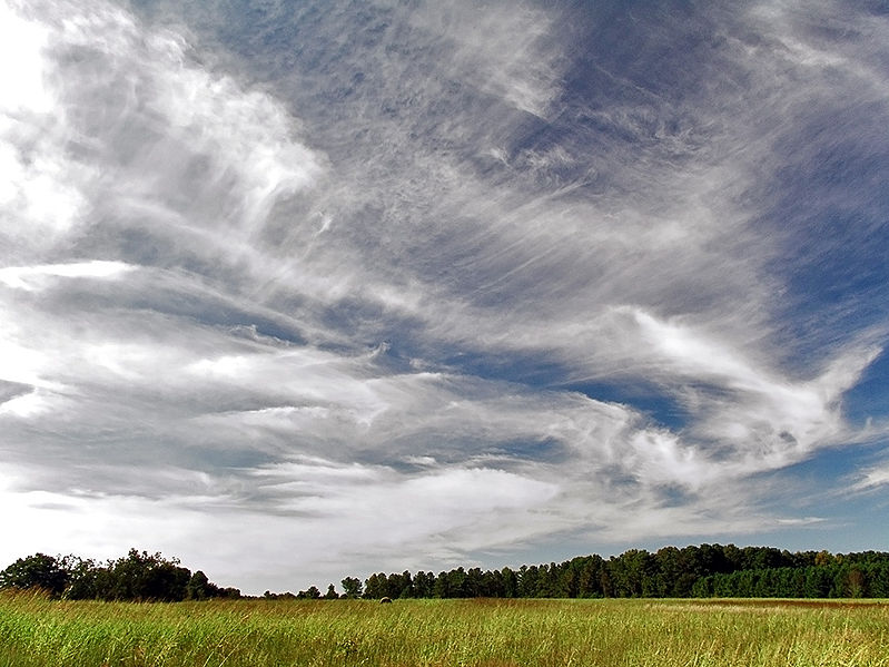
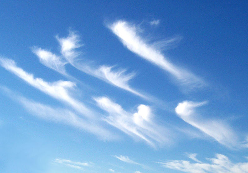
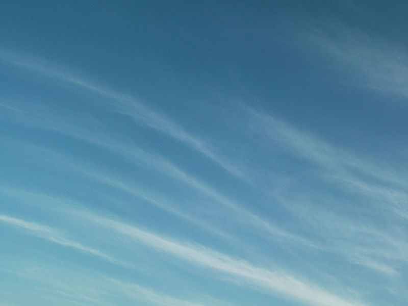
Filamentary means "stringy" or "streaky". If you
imagine trying to paint a Ci
cloud you might dip a small pointed brush in white paint
brush it quickly and lightly across a blue colored
canvas. Here are some pretty good photographs of
cirrus clouds (they are all from a Wikipedia
article on Cirrus Clouds)
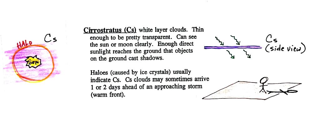
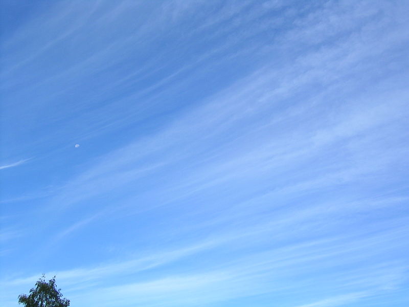
A
cirrostratus cloud is a thin uniform white layer cloud (not
purple as shown in the figure) covering part or all of the
sky. They're so thin you can sometimes see blue sky
through the cloud layer. Haloes are a pretty sure
indication that a cirrostratus cloud is overhead.
If you were painting Cs clouds you could dip a broad brush
in watered down white paint and then paint back and forth
across the canvas. Look
down at your feet and see if your body is casting a
shadow.
Haloes and sundogs
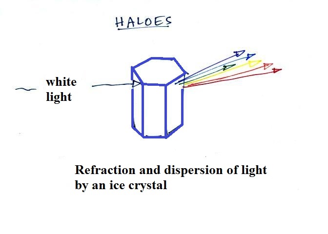
Haloes are produced when white light (sunlight or moonlight)
enters a 6 sided ice crystal. The light is bent
(refraction). The amount of bending depends on the
color (wavelength) of the light (dispersion). The
white light is split into colors just as when light passes
through a glass prism. Crystals like
this (called columns) tend to be randomly oriented in the
air. That is why a halo forms a complete ring around
the sun or moon. You don't usually see all the colors,
usually just a hint of red or orange on the inner edge of
the halo.
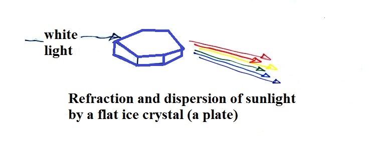
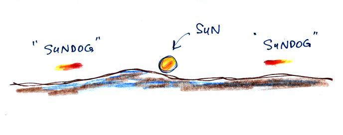
This is a
flatter crystal and is called a plate. These crystals
tend to all be horizontally oriented and produce sundogs
which are only a couple of small sections of a complete
halo. A sketch of a sundog is shown below.
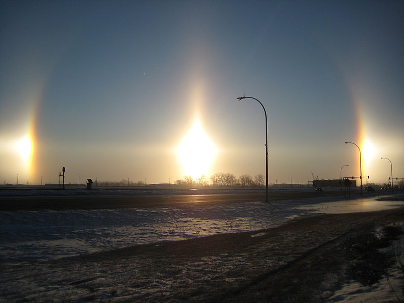
Sundogs are pretty common. Keep an eye out for
them whenever you see high thin clouds in the sky at sunrise or
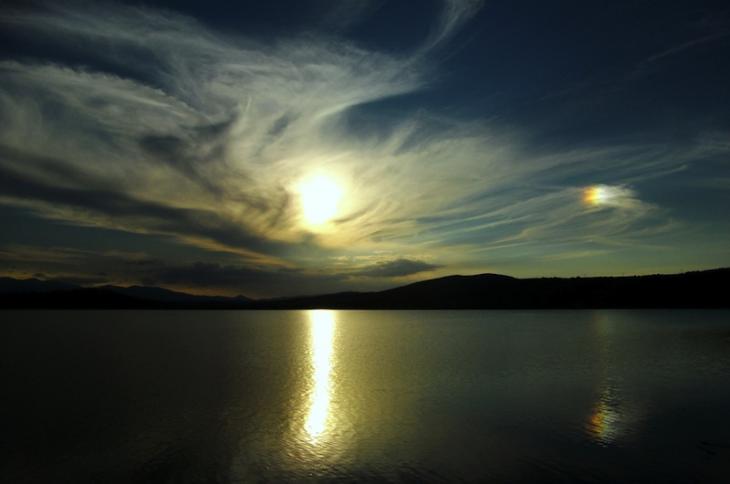
sunset. The photograph above (source)
is like you might see in Tucson (except perhaps for the lake in
the foreground). The sun is in the center of the
photograph and the sundog is send at right. The photograph
also illustrates how thin
cirriform clouds will often appear thicker at sunrise or
sunset because the rays of sunlight shine through them
at an angle.
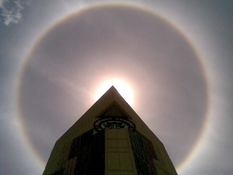
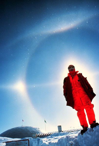
A very bright halo is shown at upper
left with the sun partially blocked by a building
(the cloud is very thin and most of the sunlight is
able to shine straight through). A halo like
this would draw a crowd. Note the sky inside
the halo is darker than the sky outside the
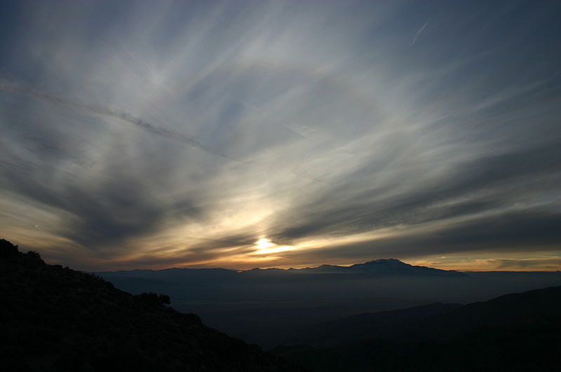
halo. The halo at upper right is more typical
of what you might see in Tucson. Thin cirrus
clouds may appear thicker at sunrise or sunset
because the sun is shining through the cloud at a
steeper angle. Very bright sundogs (also known
as parhelia) are shown in the photograph at bottom
left. The sun in the photograph at right is
behind the person. You can see both a halo and
a sundog (the the left of the sun) in this
photograph. Sources of these
photographs: upper
left, upper
right, bottom
row.
If you spend enough time
outdoors looking up at the sky you will eventually see
all 10 cloud types.
Cirrus and cirrostratus clouds are fairly
common. Cirrocumulus clouds are a little more
unusual.
The same is true with animals, some are more commonly seen in the desert
around Tucson (and even in town) than others. If you click on the link you'll
see pictures of some of the wild animals that live in and
around Tucson. With the exception of a skunk I've seen
all of them in my neighborhood in central Tucson (often in my
backyard).
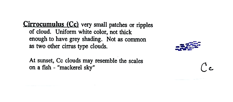
To
paint a Cc cloud you could dip a sponge in white paint
and press it gently against the canvas (as I tried to do
earlier). You would leave a patchy, splotchy
appearing cloud (sometimes you might see small
ripples). It is the patchy (or wavy) appearance
that makes it a cumuliform cloud.
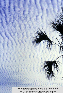
The table below compares
cirrostratus (the cloud on the left without texture)
with a good example of a cirrocumulus cloud (the
"splotchy" appearing cloud on the right). Both
photographs are from the Wikipedia article mentioned
earlier.
Cirrostratus - Cirrocumulus comparison
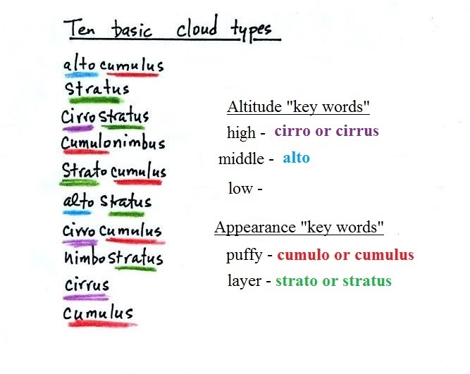
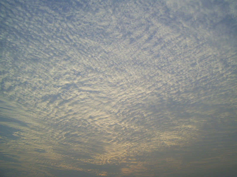
Middle altitude clouds
Altocumulus clouds are pretty
common. Note since it is hard to accurately judge
altitude, you must rely on cloud element size (thumbnail size
in the case of Ac) to determine whether a cloud belongs in the
high or middle altitude category. The cloud
elements in Ac clouds appear larger than in Cc because the cloud
is closer to the ground. A couple of photographs are shown
below (source: Ron Holle for WW2010 Department of
Atmospheric Sciences, the University of Illinois at
Urbana-Champaign)
There's a much larger collection in this gallery
of images. The fact that there are so many examples
is an indication of how common this particular type of cloud is.
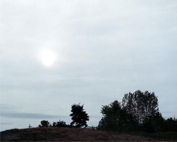
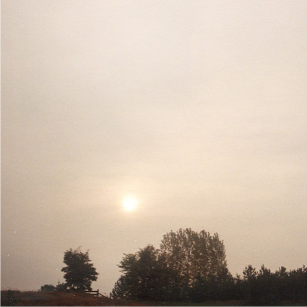
Altostratus clouds are
thick enough that you probably
won't see a shadow if you look down at your
feet. The sun may or may not
be visible through the cloud.
Three examples are shown below (the first is from a
Wikipedia article, the
middle and right photograph are from an Environment
Canada web page)
When (if) an
altostratus cloud begins to produce precipitation,
its name is changed to nimbostratus.
Without being there,
it is hard to tell whether this is an altrostratus, a
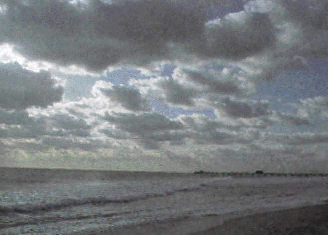
nimbostratus, or a stratus cloud.
The smaller darker cloud fragments that are below
the main layer cloud are "scud" (stratus fractus)
clouds (source
of this image).
Low
altitude clouds
Pretty
common. This cloud name
is a little unusual because the
two key words for cloud appearance have been combined,
but that's a good description of this cloud type - a "lumpy
layer cloud". Remember there isn't a key word for low
altitude clouds.
|
|
Because they are closer to
the ground, the separate patches of Sc are
bigger, about
fist size (sources of these
images:left
photo, right
photo ).
The patches of Ac, remember, were about thumb
nail size.. If the cloud fragments in the
photo at right are clearly separate from each
other (and you would need to be underneath the
clouds so that you could look to make this
determination) these clouds would probably be
"fair weather" cumulus. If the patches of
cloud are touching each other (clearly the case
in the left photo) then stratocumulus would be
the correct designation.
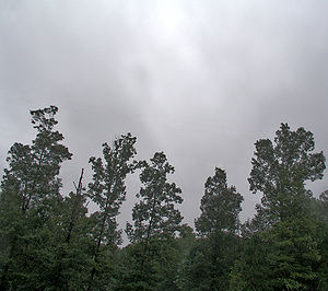
No photographs
of stratus clouds, sorry. Other than being closer
to the ground they really aren't much different from
altostratus or nimbostratus.
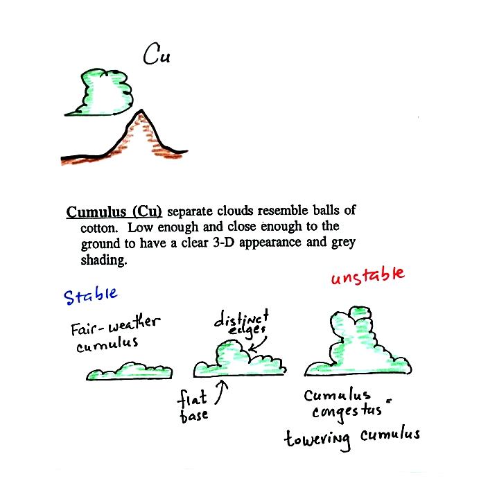
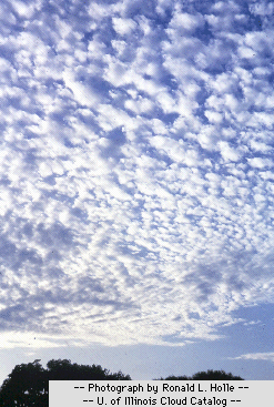
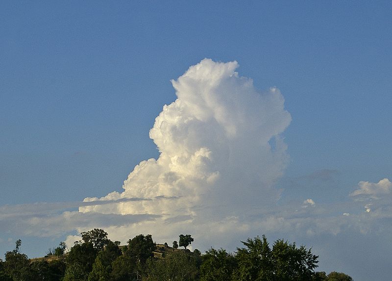
Cumulus
clouds come with different degrees of vertical
development. The fair weather cumulus clouds don't grow
much vertically at all. A cumulus congestus
cloud is an intermediate stage between fair weather cumulus
and a thunderstorm.
Photographs
of "fair weather"
cumulus on the left (source)
and cumulus congestus
or towering cumulus on the right
(source)
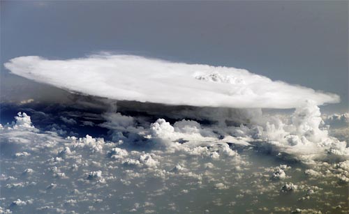
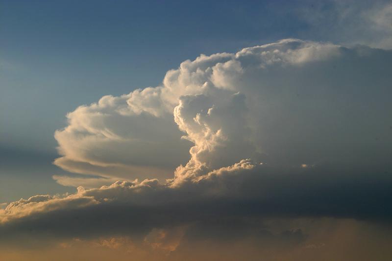
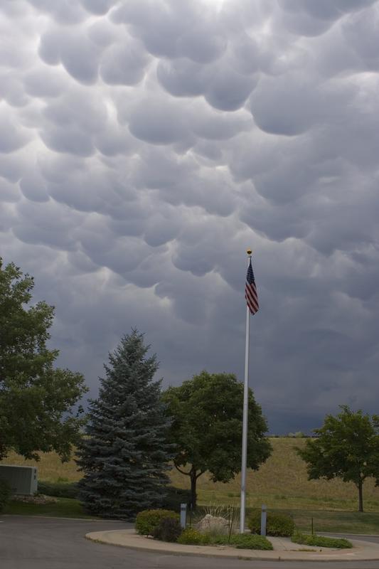
Thunderstorms
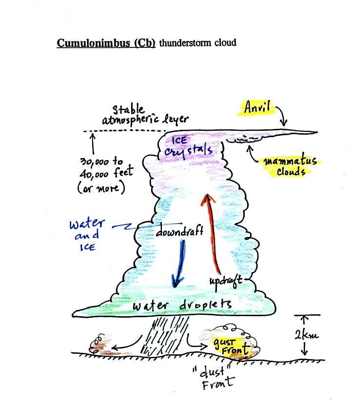
There
are lots of distinctive features on cumulonimbus clouds
including the flat
anvil top and the lumpy mammatus
clouds sometimes found
on the underside of the anvil.
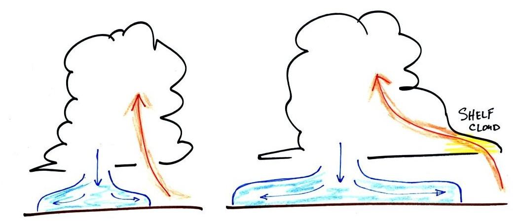
Cold
dense downdraft winds hit the ground below a
thunderstorm and spread out horizontally underneath the
cloud. The leading edge of these winds produces a
gust front
(in Arizona dust front might be a little more
descriptive). Winds at the ground below a
thunderstorm can exceed 100 MPH, stronger than many
tornadoes.
The top of a thunderstorm
(violet in the sketch) is cold enough that it will be
composed of just ice crystals. The bottom (green) is
composed of water droplets. In the middle of the
cloud (blue) both water droplets and ice crystals exist
together at temperatures below freezing (the water
droplets have a hard time freezing). Water and ice
can also be found together in nimbostratus clouds.
We will see that this mixed phase region of the cloud is
important for precipitation formation. It is also
where the electricity that produces lightning is
generated.
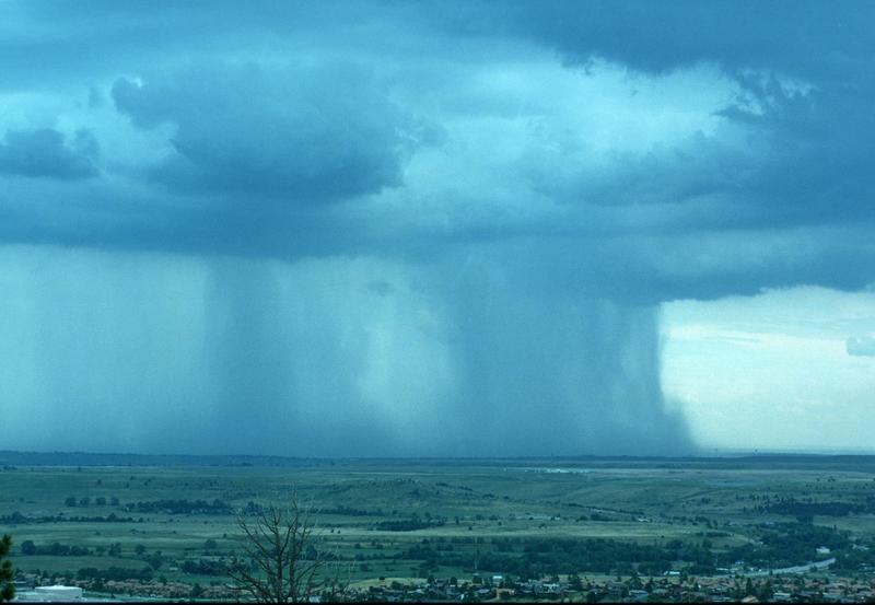
The top left
photo shows a thunderstorm viewed from space (source: NASA Earth
Observatory). The flat anvil top is the dominant
feature. The remaining three photographs are from the UCAR Digital Image
Library. The bottom left photograph shows heavy by
localized rain falling from a thunderstorm. At bottom
right is a photograph of mammatus clouds found on the
underside of the flat anvil cloud.
Cold air
spilling out of the base of a thunderstorm is just beginning
to move outward from the bottom center of
the storm in the picture at
left. In the picture at right the cold air has moved
further outward and has begun to get in the way of the
updraft. The updraft is forced to rise earlier and a
little ways away from the center of the thunderstorm.
Note how this rising air has formed an extra lip of
cloud. This is called a shelf cloud.
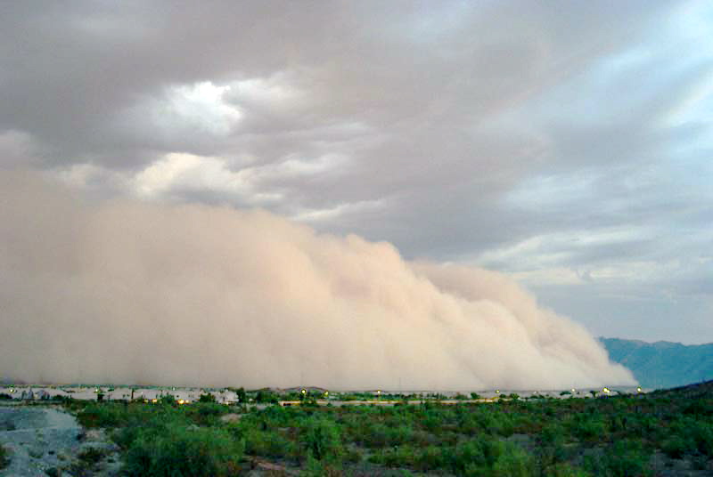
Here's a photograph of the dust stirred
up by the thunderstorm downdraft winds (blowing into
Ahwatukee, Pheonix on Aug. 22, 2003). The thunderstorm
would be off the left somewhere and the dust front would be
moving toward the right. Dust storms like this are often
called "haboobs" (source of
this image).
We'll learn more about the
hazards associated with strong downdraft winds later in the
semester when we cover thunderstorms.
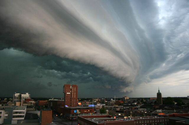
Shelf
clouds can sometimes be quite
impressive (the picture above is from a Wikipedia
article on arcus clouds).
The main part
of the thunderstorm would be to the left. Cold air is
moving from left to right in this picture. The shelf cloud
forms along the advancing edge of the gust front.
You should end up with something like this at the end of
class. Your cloud chart will also include some words of
description or clues that help you identify and name a
cloud. I've used abbreviations for the cloud names (Cc =
cirrocumulus, As = altostratus etc).
Here's a link to a cloud
chart on a National Weather Service webpage with
actual photographs. 27
clouds are shown. This is because slightly different
versions of the 10 main cloud types are shown.
We often work on a cloud chart during class. Here's the
example from the Fall 2016 semester.
