Wednesday Mar. 28
Midterm grade summaries were handed out in class today. Answers
to the Humidity Optional Assignment were also distributed.
The Quiz #3 Study Guide is now available
online.
Since we
have just finished the section in the text on clouds, we will look
briefly at the three types of
satellite photographs and what they tell you about clouds or wind
motions in the atmosphere. You'll find these discussed on pps
99-100 in the photocopied class notes. You'll also find this
topic discussed on pps 236-240 in the text (Chap 9).
The most common type of satellite photograph is an infrared satellite
photograph.
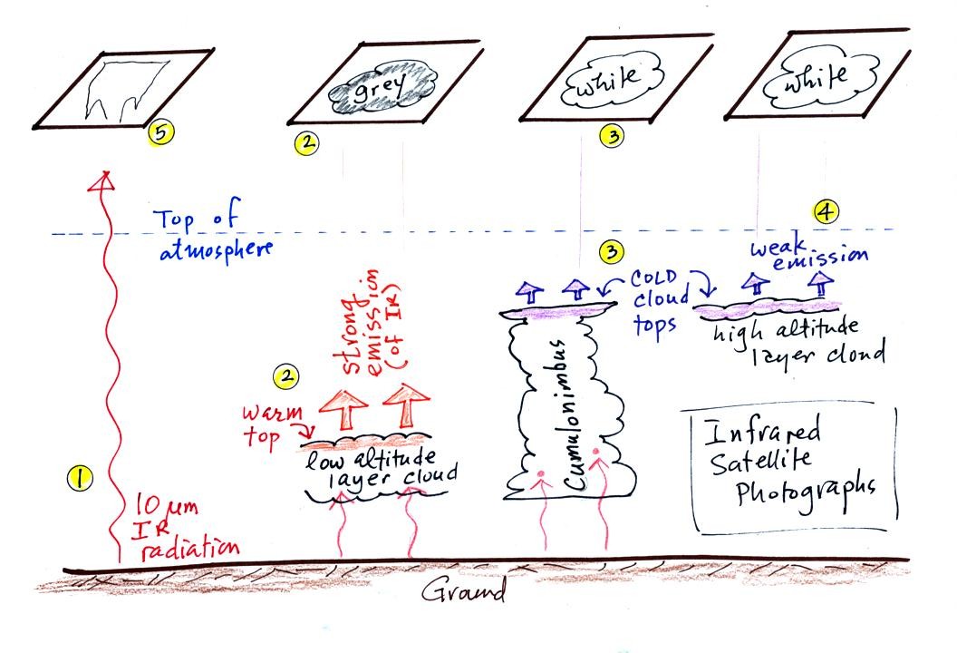
1. An infrared satellite photograph detects the 10 um IR
radiation
actually
emitted by the ground or by clouds. You don't depend on seeing
reflected
sunlight, so clouds can be photographed during the day and at
night. You may recall that 10 um radiation is in the middle of
the atmospheric window, so this radiation is able to pass through air
without being absorbed.
2. Clouds absorb 10 um radiation and then reemit
radiation. The top surface of a low altitude cloud will be
relatively warm. Warmer objects emit IR radiation at a greater
rate or at higher intensity (Stefan Boltzmann law from Chap. 2).
This is shown as grey on an IR satellite photograph. A
grey unimpressive looking cloud on an IR
satellite photograph may actually be a thick nimbostratus cloud that is
producing a lot of rain or snow.
3. Cloud tops found at high altitude are cold and emit IR
radiation at a lower rate or at lower intensity. This shows up
white on an IR photograph.
4. Two very different clouds (a thunderstorm and a
cirrostratus cloud) would both appear white on the satellite photograph
and would be difficult to distinquish.
5. The ground changes temperature during the course of the
day. The "color" of the ground changes from black (afternoon when
the ground is warmest) to grey (early morning when the ground is cold)
during the course of a day. The ocean right alongside doesn't
change temperature much during the day and remains grey throughout the
day.
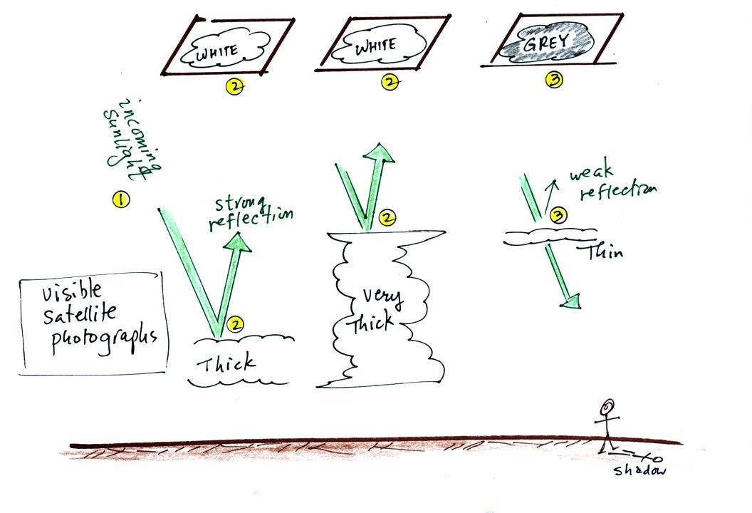
A visible satellite photograph photographs sunlight that is reflected
by clouds. You won't see much on a visible satellite photograph
at night. Thick clouds are good reflectors and appear
white. Thinner clouds don't reflect as much light and appear
grey. The low altitude layer cloud and the thunderstorm would
both appear white on this photograph and would be difficult to
distinquish.
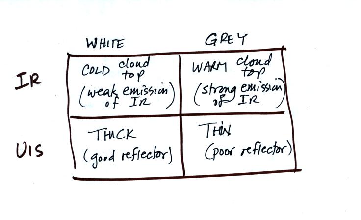
Here's a summary (not shown in
class) of what we have learned so far.
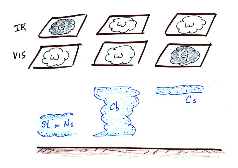
The figure below (not shown in
class either) shows how if you combine both visible and IR
photographs you can begin to distinquish between different types of
clouds.
There is one more type of satellite image worth mentioned, a water
vapor image.
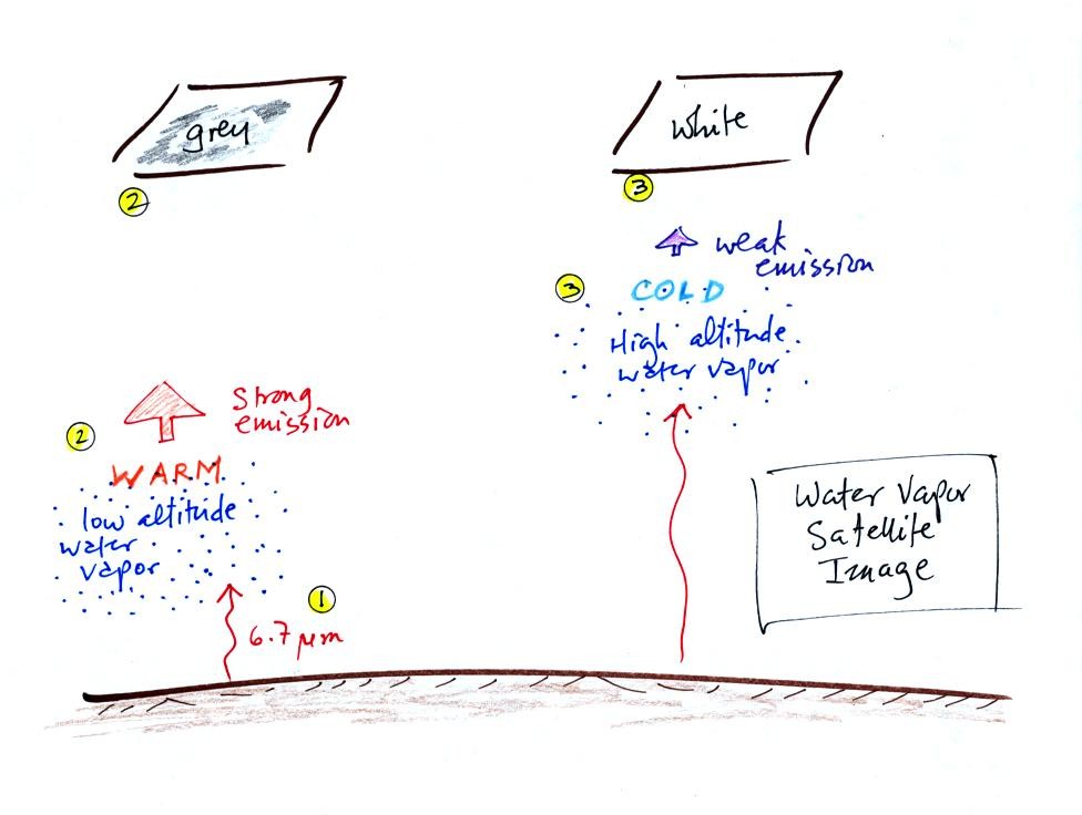
This is also a type of IR photograph. It detects a different
wavelength of IR radiation. 6.7 um radiation is absorbed and
emitted by water vapor in the atmosphere. Warm low altitude water
vapor appears grey and unimpressive. Higher altitude water vapor
appears white on the satellite photograph. But
remember the high altitude
air is cold and there isn't much water vapor up there. The
utility of these photographs is not to show you whether a lot of
moisture is moving into an area but rather they reveal wind motions in
regions where there aren't clouds.
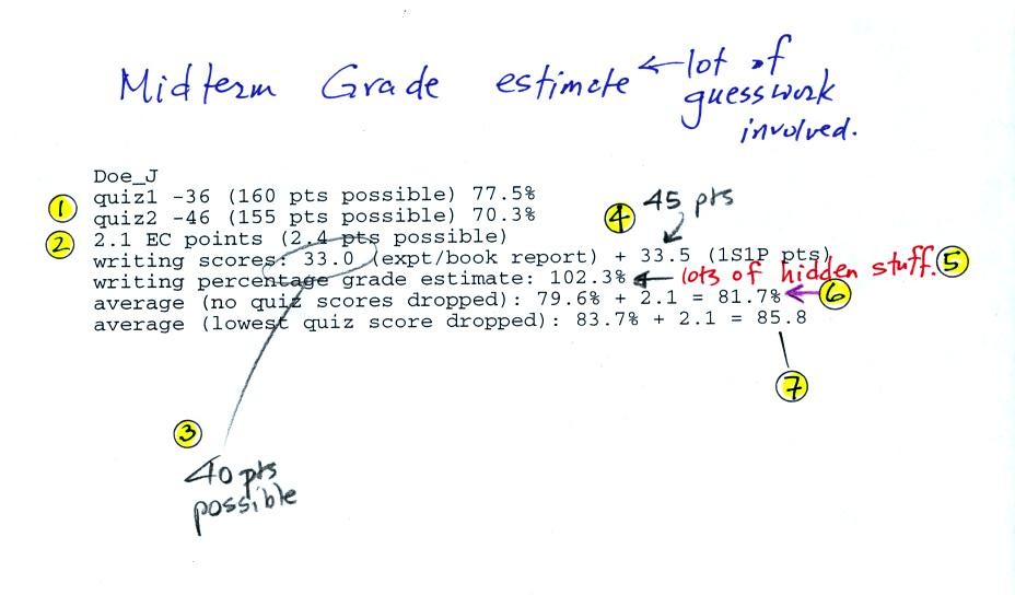
Here is an example of one of the midterm grade estimates.
These will give you an idea of how well you are doing in the class and
are a way of checking to be sure all of your grades have been entered
into the computer correctly. It is important to remember that we
still have quite a bit of material to cover before the end of the
semester; your grade can go up or down between now and then.
1. Shows the two quiz scores and the percentage grade.
2. Shows the extra credit points you have earned so far on
the optional assignments.
3. If you have completed an experiment or book report the
grade should appear here. If you haven't turned in a report (or
if it hasn't been graded yet), you'll see a 0. The computer
assumes an average score to show the effect it will have on your
overall score.
4. Shows the 1S1P points you have earned so far. You
can earn up to 45 pts by the end of the semester.
5. This is an estimate of your writing writing percentage
grade. The writing percentage grade counts the same as one quiz.
6. This is the overall average (quiz grades and writing
grade with extra credit added in) that must be 90.0 or above at the end
of the semester in order to not have to take the final exam.
7. This is the overall average with the lowest quiz grade
dropped. This is the average you have if you do have to take the
final exam.
We took a
short detour at this point. The figure below shows some of the
features to look for the next time you see a rainbow. Rainbows
are produced by the refraction of light as in enters and exits a
raindrop.
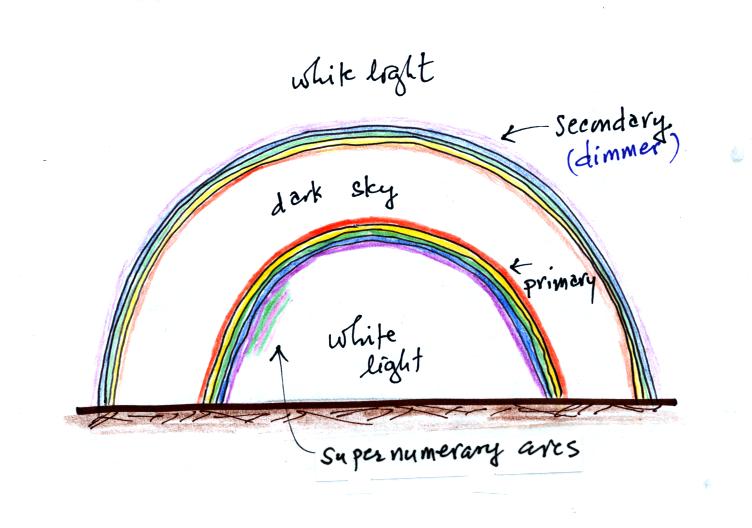
This shows a "double rainbow." The primary rainbow is brightest
and is found below the secondary rainbow. Red light is found on
the outside edge of the primary rainbow. The secondary rainbow is
dimmer than the primary and the order of the colors is reversed.
Now some features you might have noticed. The next time you see a
rainbow compare the brightness of the sky between the two rainbows with
the sky above and below the rainbows. You should see that the sky
in between appears to be darker. On some occasions you may see
some additional bands of color (usually alternating green and pink) on
the bottom edge of the primary rainbow. These are supernumerary
arcs. These are visible when the raindrops producing the rainbow
are all about the same size.
We just barely got started on the next topic formation of
precipitation. It is not as easy to make precipitation as you
might think. Only nimbostratus and cumulonimbus clouds are able
to do it.
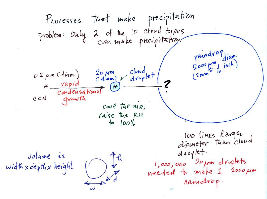
This figure shows typical sizes of cloud
condensation nuclei (CCN), cloud droplets, and raindrops. As we
saw in the cloud in a bottle demonstration it is relatively easy to
make cloud droplets. You cool moist air to the dew point and
raise the RH to 100%. Water vapor
condenses pretty much instantaneously onto a cloud condensation nucleus
to form a cloud droplet. It
would take much longer (days) for condensation to turn a cloud droplet
into a
raindrop. You know that you don't have to wait around that long
for a cloud to begin to rain or snow.
Part of the problem is that it takes about 1 million
cloud droplets of water to make a raindrop.
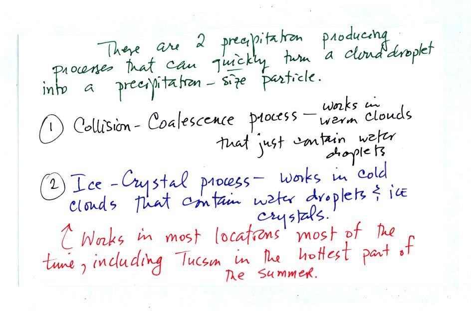
There are two processes capable of quickly turning cloud droplets
into precipitation particles in a cloud.
The collision coalescence process works in clouds that are
composed of water droplets only. Clouds like this are only found
in
the tropics. We'll see that this is a pretty easy process to
understand.
The ice crystal process produces precipitation everywhere else.
This is the process that makes rain in
Tucson, even in the hottest part of the summer. There is one part
of this process that is a little harder to understand. We won't
have to worry about that until Friday.