Friday Mar. 23, 2007
The optional assignment and the Experiment #3 reports are due next
Monday.
When air
above the ground reaches 100% relative humidity it is much easier for
water vapor to condense onto small particles in the air called
condensation nuclei than to just form a small droplet of water.
There are hundreds even thousands of these small particles in every
cubic centimeter of air. We can't see them because they are so
small.
You can learn why it is so hard to form small droplets of
pure water by
reading the top portion of p.
92 in the photocopied
class notes.
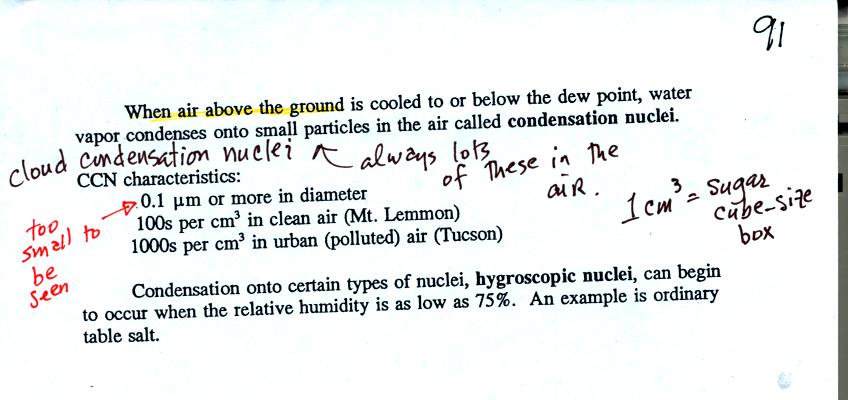
Water vapor will condense onto certain kinds of condensation
nuclei
even when the relative humidity is below 100% (again you will find some
explanation of this on the bottom of
p. 92).
These
are called hygroscopic
nuclei.
A short video showed how water vapor would, over time,
preferentially
condense onto small grains of salt rather than small spheres of glass.
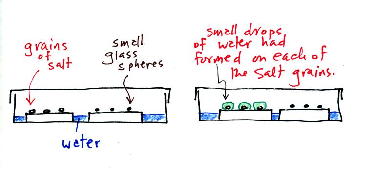
The start of the video at left showed the small grains of
salt were
placed on a platform in a petri dish
containing water. Some small spheres of glass were placed in the
same
dish. After about 1 hour small drops of water had formed around
each
of the grains of salt (shown above at right). The figure above wasn't shown in class.
In humid parts of the US, water will condense onto the grains of salt
in a salt shaker causing them to stick together. Grains of rice
apparently will keep this from happening and allow the salt to flow
freely out of the shaker when needed.
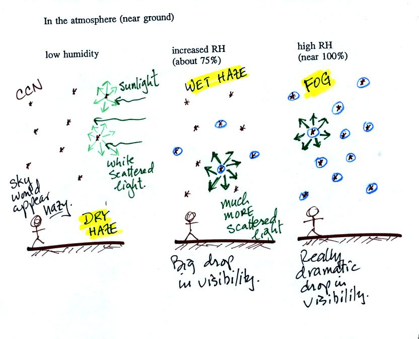
This figure shows how cloud
condensation nuclei and increasing relative humidity can affect the
appearance of the sky and the visibility.
The air in the left most figure is relatively dry. Even though
the condensation nuclei particles are too small to be seen with the
human eye you can tell they are there because they scatter
sunlight. When you look at the sky you see the deep blue color
caused by scattering of sunlight by air molecules mixed together with
some white
light scattered by the condensation nuclei. This changes
the color of the sky from a deep blue to a bluish white
color. The more particles there are the whiter the sky
becomes. This is called "dry haze."
The middle picture shows what happens when you drive from the dry
southwestern part of the US into the humid
southeastern US. One of the first things you would notice is the
hazier
appearance of the air and a decrease in visibility. Because the
relative humidity is high,
water vapor begins to condense onto some of the condensation nuclei
particles (the hygroscopic nuclei) in the air and forms small water
droplets. The water droplets scatter more sunlight than just
small particles alone. The increase in the amount of scattered
light is what gives the air its hazier appearance. This is called "wet
haze."
Finally when the relative humidity increases to 100% fog forms.
Fog can cause a severe drop in the visibility.
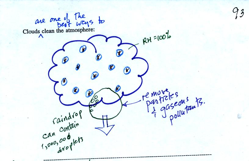
Clouds are one of the best ways of cleaning the atmosphere
(cloud
droplets form on particles, the droplets clump together to form a
raindrop, and the raindrop carries the particles to the ground).
A raindrop can contain 1 million cloud droplets so a single raindrop
can remove a lot of particles from the air. You may have noticed
how clear the air seems the day after a rainstorm. Gaseous
pollutants can dissolve in the water droplets and be carried to
the ground by rainfall also.
Now armed
with some knowledge of condensation nuclei, humidity, and scattering of
light we are ready for another demonstration. We will try to make
a cloud in a bottle.
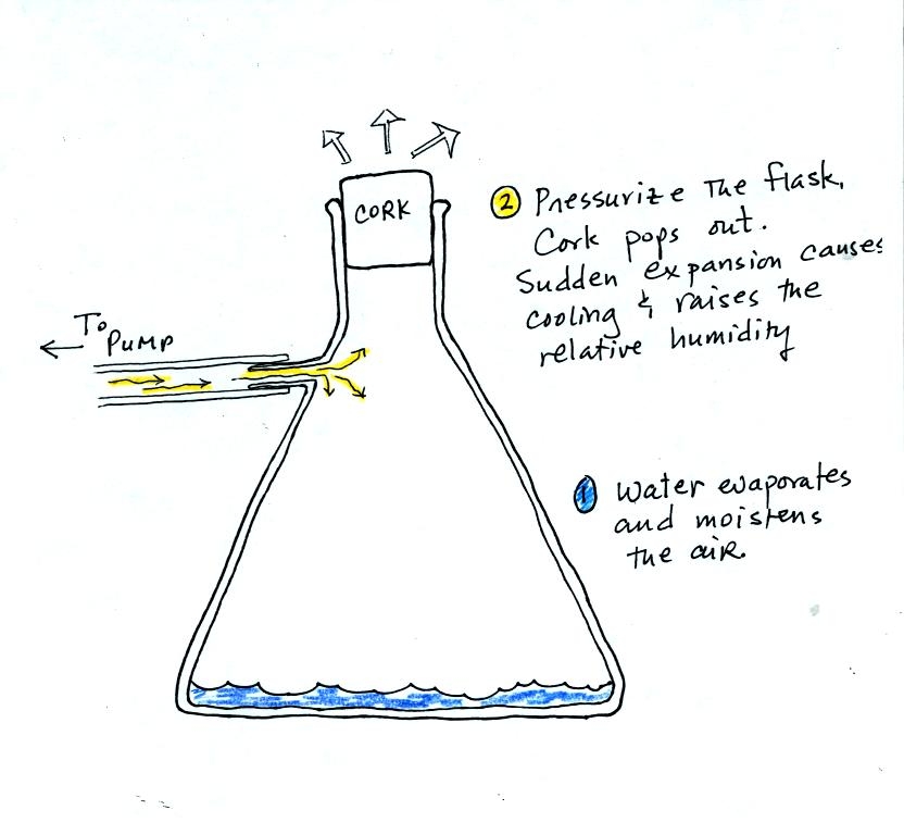
We used a strong thick-walled 4 liter flask (flasks
like this are designed not to implode when all of the air is pumped out
of them, they aren't designed not explode when pressurized).
There
was a little
water in the bottom of the flask to moisten the air in the flask.
Next we pressurized the air in the flask. At some point the
pressure blows the cork out of the top of the flask. The air in
the flask expands outward and cools. This cooling increases the
relative humidity of the moist air in the flask to 100% (probably more
than 100%) and water vapor condenses onto cloud condensation nuclei in
the air. A faint cloud became visible at this point. The
cloud droplets are too small to be seen with the human eye. You
can see the cloud because the water droplets scatter light.
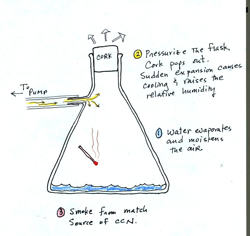
The demonstration was repeated a second time (perhaps
a
third time)
with one small change. A burning match was dropped into the
bottle. The smoke from the match consisted of lots of very small
particles that act as condensation nuclei. The cloud that formed
this time was somewhat "thicker" and easier to see.
The
concentration of particles in the air can have on the appearance of a
cloud.
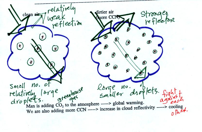
A cloud composed of a large number of small droplets is more
reflective
than a cloud composed of a smaller number of larger
droplets.
This something that interests the people studying climate change.
Combustion of fossil fuels adds carbon dioxide to the atmosphere but
also adds condensation nuclei. The increasing greenhouse gas
concentrations are expected to warm the earth. More particles
might make clouds more reflective though which could cool the earth.
We started
off on a small detour in the second part of the class.
There are a variety of optical phenomena in the atmosphere (rainbows,
haloes, sundogs, mirages, the green flash) that occur because of
refraction.
Refraction is the bending of light that occurs when light travels from
one transparent material into another.
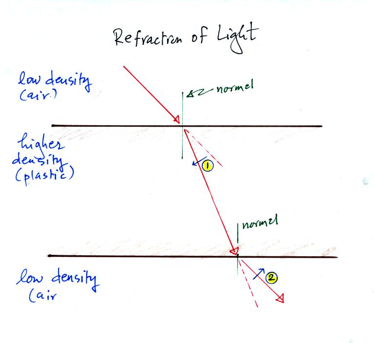
Light entering a denser material at an angle bends toward the
normal. The normal is a line drawn perpendicularly to the
boundary between the two materials. This is shown at the top of
the figure (point 1) as a beam of red laser light passes from air into
a piece of
plastic.
Light passing from a high density to a low density material bends away
from the normal. You can see this is the lower part of the figure
(point 2) above as the light beam travels from the plastic back into
the air.
The following figures show some of the atmospheric optical phenomena
that are produced by refraction.
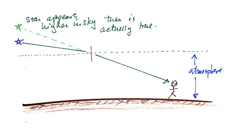
In this figure light from a distant star is bent as it passes from
space (density = 0) into the atmosphere (higher density). The
person on the ground thinks the star is higher in the sky than is
really the case.
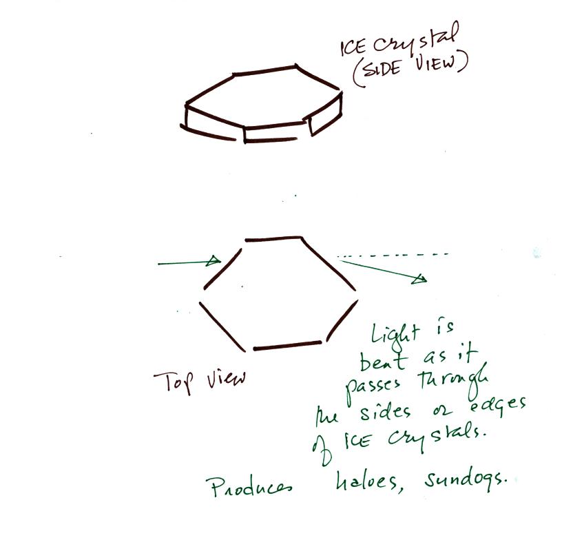
A halo is a ring of light that surrounds the sun or moon. Sundogs
are patches of light seen to the left and right of the setting (or
rising) sun. Both are produced by bending of light that occurs as
light travels from low density air into (and out of) higher density
ice.
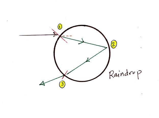
Light follows a more complicated path to produce a rainbow. The
light is first bend (toward the normal at Point 1) as it passes from
the air into the water drop. The ray of light is reflected off
the back inside surface of the raindrop at Point 2 and is refracted
again (away from the normal at Point 3) as it exits the raindrop.
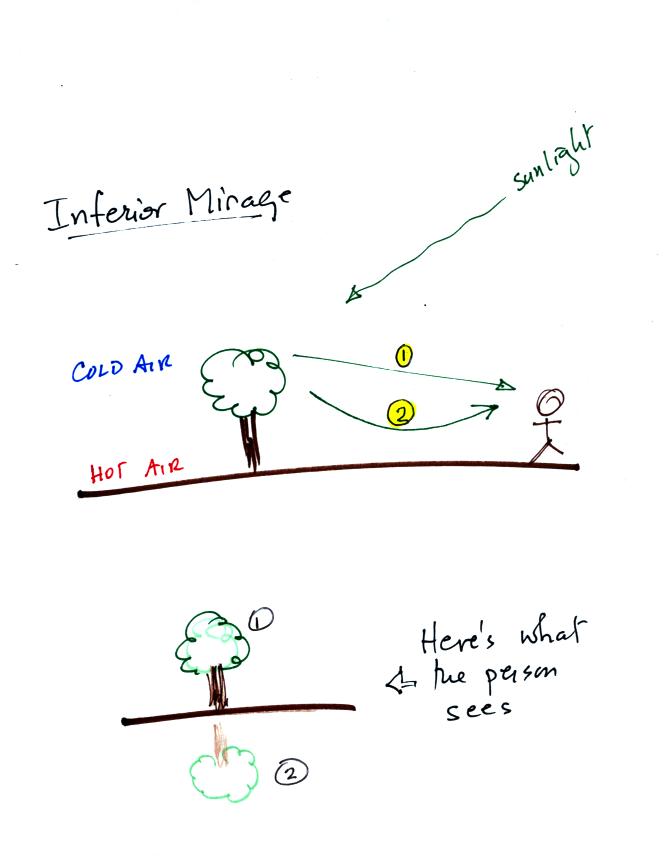
Production of an inferior mirage is also a little complicated.
Sunlight strikes the tree is rays of light are scattered in all
directions. One ray (1) goes directly to the person. The
other is initially directed downward toward the ground. The hot
low density air next to the ground bends this ray of light and
eventually sends it toward the person (2). The person sees two
images of the tree. The real image when looking along light ray 1
and a virtual image when looking down in the direction of light ray 2.