Friday, Apr. 20, 2007
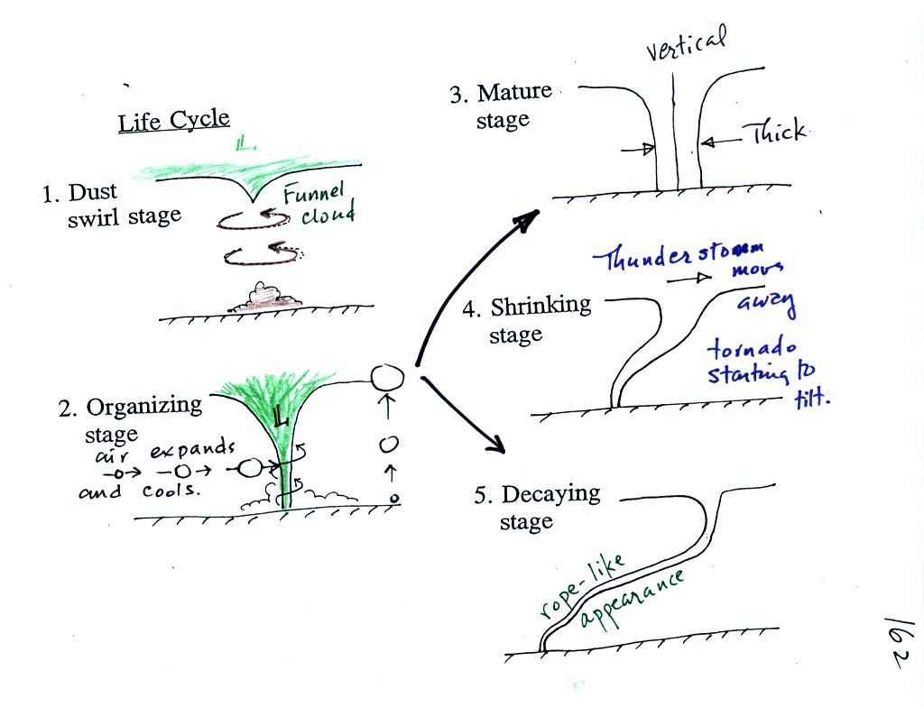
Tornado life cycle (don't worry about learning
the names of
the various stages). Tornadoes begin in and descend from a
thunderstorm. You might see a funnel cloud dropping from the base
of the thunderstorm. Spinning winds will probably be present
between the cloud and ground before the tornado cloud becomes
visible. The spinning winds can stir up dust at ground
level. The spinning winds might also be strong enough at this
point to produce some minor damage.
In Stage 2, moist air moves horizontally toward the low pressure in the
core of the tornado. This sideways moving air will expand and
cool just as rising air does. Once the air cools enough (to the
dew point temperature) a cloud will form. The tornado is colored
green above just to reinforce the fact that it is a true cloud and
isn't
just composed of dust (dust may mix with the cloud and turn the
tornado brown)
Tornadoes can go from Stage 2 to Stage 3 (this is what the strongest
tornadoes do) or
directly from stage 2 to stage 5. Note a strong tornado is
usually vertical and thick as shown in Stage 3.
The thunderstorm and the top of the tornado will move faster than the
surface winds and the bottom of the tornado. This will tilt and
stretch the tornado. The rope like appearance in Stage 5 is
usually a sign of a weakening tornado.
Tornadic thunderstorms have rotating updrafts called
mesocyclones
(cyclone refers to winds spinning around low pressure, meso means
medium size scale). Air moving into toward the low pressure core
of the mesocyclone will expand and cool. The cloud that extends below
the cloud base and surrounds the mesocyclone is called a wall
cloud. The largest and strongest tornadoes will generally come
from the wall cloud.
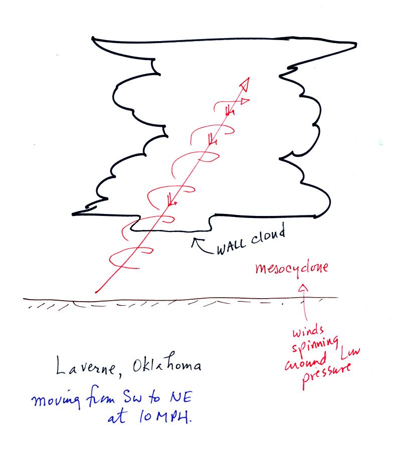
At this point we looked at the first of three video
segments.
The video showed the early stages in the life cycle of a tornado in
Laverne, Oklahoma. The tornado was initially 200 to 300 yards
wide but grew to about 1/4 of a mile in diameter. The tornado was
initially almost stationary then began to move toward the NE at about
10 MPH. This tornado was eventually given an F3 rating (on the
Fujita Scale), a moderately strong tornado.
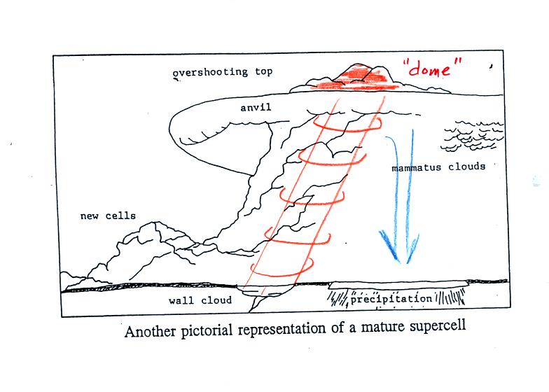
A sketch showing some of the characteristic features of
supercell thunderstorms. Supercells are first of all much larger
than ordinary air mass
thunderstorms. In
an ordinary thunderstorm the updraft is unable to penetrate into the
very
stable air in the stratosphere. The upward moving air just
flattens out and forms an anvil. In a supercell the
rotating updraft (shown in orange above) is strong enough to penetrate
into the stratosphere a little ways. This
produces the overshooting top or dome feature above. A wall cloud
and a tornado are shown at the bottom of the mesocyclone. The
flanking line is a line of new cells trying to form alongside the
supercell thunderstorm.
A little more detailed sketch is shown below
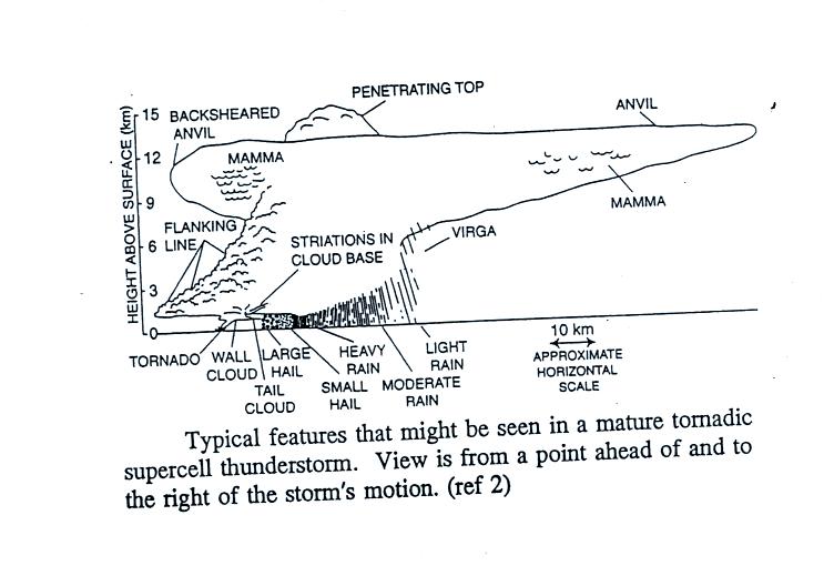
A photograph of a distant supercell thunderstorm was shown in the next
video tape. A computer simulation of the air motions inside a
supercell thunderstorm was also shown. Researchers understand the
development of a supercell pretty well. The exact process that
initiates tornado development is still unknown.
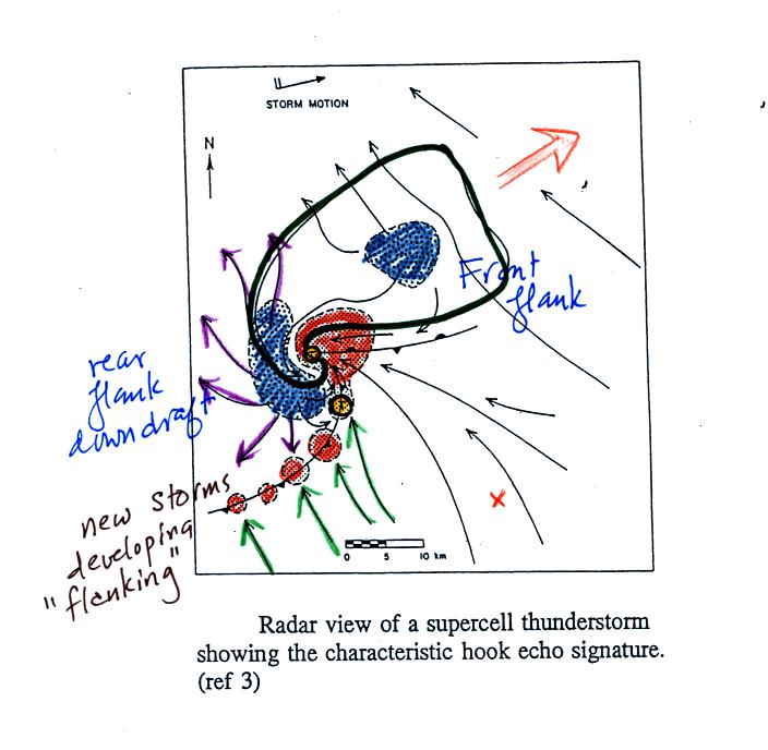
A radar picture of a supercell thunderstorm will often have
a characteristic hook shape (outlined in black above). The hook
is caused by spinning
motions inside the thunderstorm The large orange
shaded area is the
thunderstorm updraft, the mesoscylone. Smaller regions of rising
air are shown along a gust front.
Blue shaded areas shown
where precipitation falls out of the cloud. The
flanking line of new cells is forming along the gust front produced
when
cold downdraft air from the thunderstorm (purple arrows) collides with
prexisting
winds (green arrows). Weak tornadoes can sometimes form along the
gust
front. The largest and strongest tornadoes come from the
mesocylone and wall cloud.
Before
going onto the next video it would be
worthwhile to learn more about the Fujita Scale that is used to rate
tornado strength or severity. The
Fujita Scale runs from F0 (weakest) to F5 (strongest, though there are
a very few tornadoes with winds over 300 MPH that have been given an F6
rating).
The scale below is an "easy to remember" version
(you can compare this with the scale in Table 10.2 (p. 281) in the
textbook). About 2/3 rds of all tornadoes are F0 or F1 tornadoes
and have spinning winds of 100 MPH or less. Only a few percent of
tornadoes develop into F4 or F5 tornadoes, but those account for about
2/3 of all tornado deaths.
Simplified,
Easy-to-Remember version of the Fujita Scale
winds < 100 MPH
F0
|
|
F1
|
roof
damage,
mobile home tipped over
|
microburst winds can cause this degree of damage
winds 100 to 200 MPH
F2
|
roof
gone,
outside walls still standing
|
F3
|
outside
walls gone,
inside walls intact
|
winds 200 to 300 MPH
F4
|
home
destroyed,
debris nearby
|
F5
|
home
destroyed,
debris carried away
|
Some representative examples of F1 through F5 level damage were
shown in class
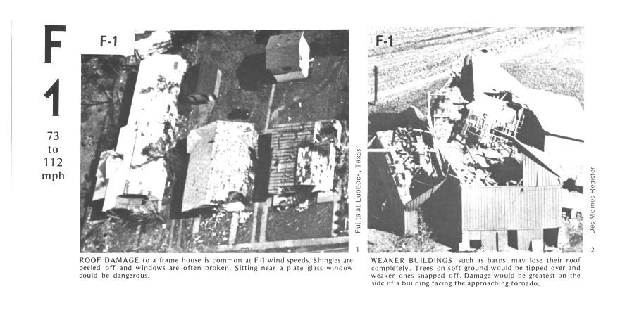
The buildings on the left suffered light roof damage. The barn
roof at right was more heavily damaged.
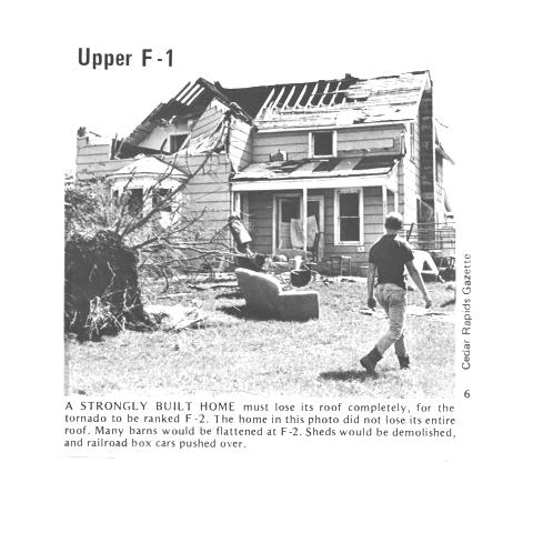
More severe damage to what appears to be a well built house roof.
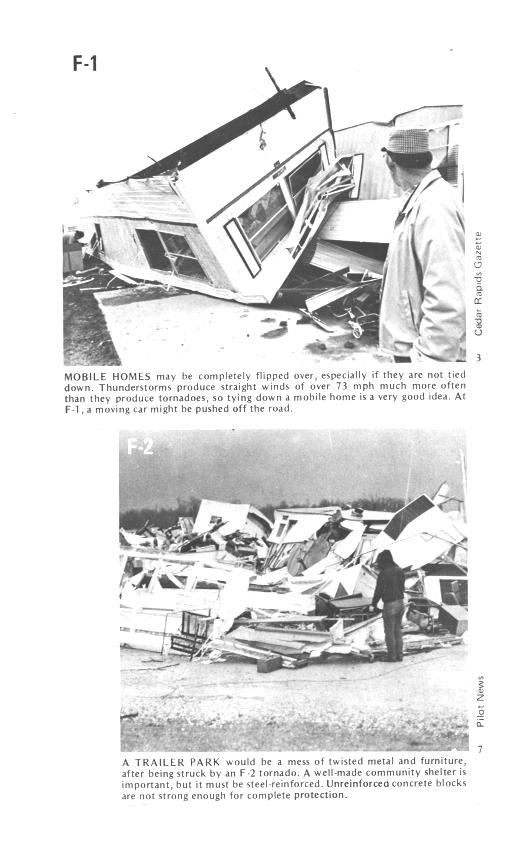
F1 tornado winds can tip over a mobile home if it is not tied down (the
caption states that an F1 tornado could blow a moving car off a
highway). F2 level winds (bottom photo) can roll and destroy the
mobile home.
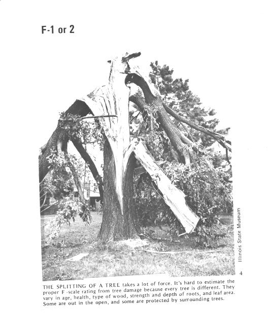
Trees, if not uprooted, can suffer serious damage from F1 or F2 tornado
winds.
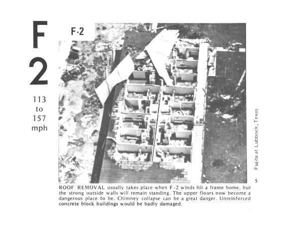
F2 level winds have completely removed the roof from this
building. The building walls are still standing.
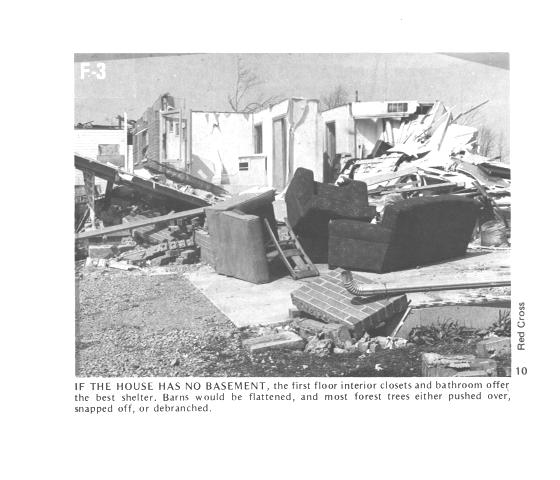
The roof is gone and the outer walls of this house were knocked
down. This is characteristic of F3 level damage. In a house
without a basement or storm cellar it would be best to seek shelter in
an interior closet or bathroom.
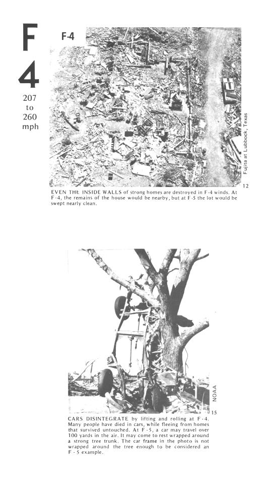
All of the walls were knocked down in the top photo but the debris is
left nearby. This is characteristic of F4 level damage. All
of the sheet metal in the car body has been removed in the bottom photo
and the car chasis has been bent around a tree. Note the tree has
been stripped of all but the largest branches.
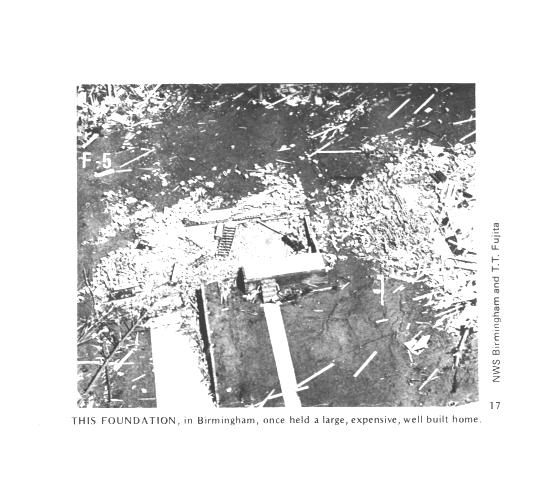
An F5 tornado completely destroyed the home in the photo above and
removed most of the debris. Only bricks and a few pieces of
lumber are left.
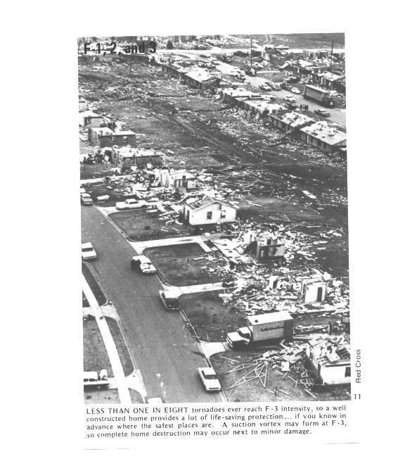
Several levels of damage are visible in this photograph. It was
puzzling initially how some homes could be nearly destroyed while a
home nearby or in between was left with only light damage. One
possible explanation is shown below
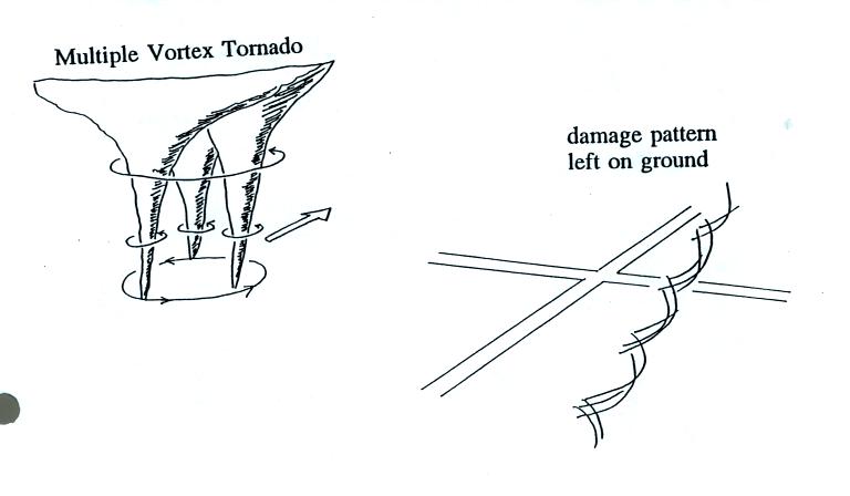
Some big strong tornadoes may have smaller more intense "suction
vortices" that spin around the center of the tornado. Tornado
researchers have actually seen the scouring pattern shown at right in
the figure above that the multiple vortices can leave behind.
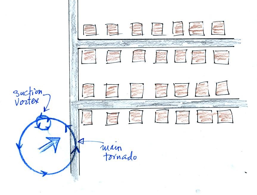
The
sketch above shows a tornado located SW of a neighborhood.
As the tornado sweeps through the neighborhood, the suction vortex will
rotate around the core of the tornado.
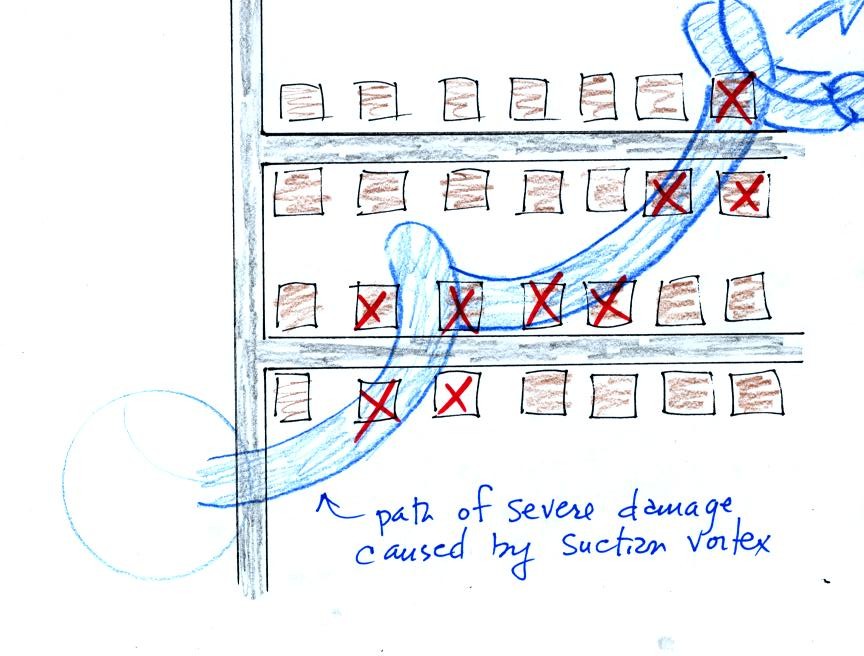
The homes marked in red would be damaged severely. The others
would receive less damage (remember, however that there would probably
be multiple suction vortices in the tornado).
The following material wasn't coveredin
class.
Air
motions inside tornadoes are complex and difficult (dangerous) to
study. Researchers resort to laboratory
simulations and computer models.
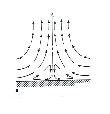
Winds thought to be found
in a weak tornado.
Friction probably
causes the closed circulation near the bottom center of the tornado.
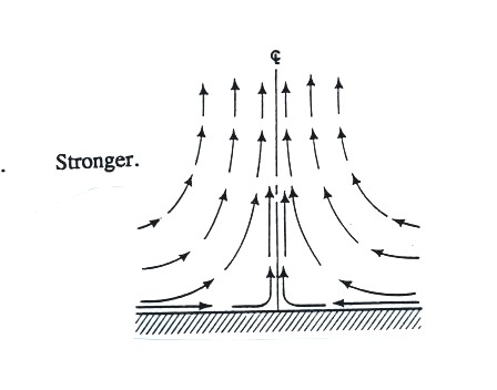
Winds in a somewhat
stronger
tornado.
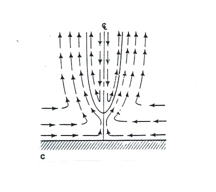
Downward
moving air is found in the core of
this tornado.
This tornado would also have a
larger diameter than
the weaker tornadoes above.
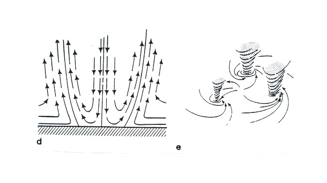
Vortex breakdown has
reached the
ground.
This may lead to the
formation of multiple vortices.