ATMO 336 Section 3 – Homework #1
Weather Map Analysis
Due in class on Thursday, February 8
This assignment is divided into two parts. In the first part, you will play the role of a TV weather forecaster by giving a broad overview of expected weather over the United States along with a more detailed forecast for Tucson based on three 500 mb forecast maps: a 48 hour (2 day) forecast, a 120 hour (5 day) forecast, and a 192 hour (8 day) forecast. In the second part you will compare the forecast maps with reality and comment on how well the computer model forecasted the 500 mb pattern. Label your answers/discussions as Part Ia, Part Ib, Part IIa, and Part IIb (see break down below). Keep your write-up short, but be sure to answer or discuss all of the items mentioned under each part.
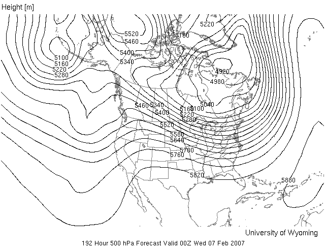
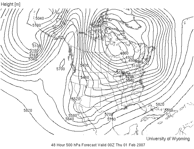
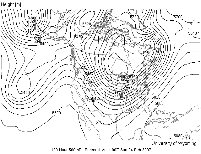
Part I – United States weather overview and Tucson forecast based on the 2, 5, and 8-day forecasts. Printouts of these maps are attached to this coversheet and distributed in class. You may also view these maps from the homework link on the course web page.
(a) For each forecast map, look for large-scale, easily identifiable features in the 500 mb pattern. Based on the position and shape of these features write a broad discussion for weather expected near these features. You don’t have mention each region of the United States in your discussion, only write about areas affected by significant features in the 500 mb pattern. For your temperature discussion, you may want to compare the 500 mb heights on the forecast map with the average 500 mb heights for this time of year (average or climatological 500 mb heights for Jan and Feb can be viewed from the homework link). Keep it brief. See example weather discussion available under the homework link on web page.
(b) For each forecast map, make a more detailed forecast for Tucson. First read/estimate the 500 mb height over Tucson from the forecast map and compare it with the average 500 mb height for this time of year. Based on this information, make a temperature forecast for Tucson relative to average (e.g., well below average, slightly below average, about average, slightly above average, or well above average). Also, forecast whether or not you expect a chance for rain in Tucson based on the 500 mb pattern. Keep it brief. See example under the homework link.
Part II – Grading the forecasts for days 2, 6, and 8. Compare the forecast 500 mb pattern for days 2, 5, and 8 with the true 500 mb patterns for each of those days. The true 500 mb maps will be available under the homework link within one day after the forecast time.
(a)
Briefly, discuss where
the forecasted 500 mb pattern was accurate and where it was not over the
continental United States, i.e., does the true 500 mb pattern look like the
forecasted pattern? Concentrate on
the large-scale, easily identifiable features. Look at both the pattern (are troughs and ridges in the same
place?) and actual heights. For
example, a trough can be in the right position, but it may be deeper, that is,
the heights in the trough may be lower than predicted. Look for significant differences, not
minor details. Also
briefly comment on whether or not you (as weather forecaster) would have been
able to accurately predict the weather 2, 5, and 8 days into the future based
on the model-forecasted 500 mb patterns.
(b)
For each true map, read/estimate the 500 mb height over Tucson
and compare it with your estimates made for the corresponding forecast
map. Briefly, how good was the 500 mb height forecast in the
vicinity of Tucson (both actual height and pattern)? What is the impact on the accuracy of your temperature and
precipitation forecast?
2 DAY FORECAST
5 DAY FORECAST
8 DAY FORECAST