Mon., May 1, 2006
Grade summaries will be held hostage until someone volunteers to
conduct the course evaluation.
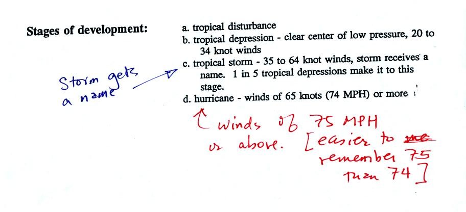
Hurricanes are now alternately given male and female names.
The
names start with A (a male name one year, a female name starting with A
the next year) at the start of
every new storm season. Five letters (Q, U, X, Y, and Z) are not
included in the list. In 2005 in the N. Atlantic they ran out of
letters of the alphabet and 6 Greek characters had to be used (Alpha,
Beta, Gamma, Delta, Epsilon, and Zeta). The last storm of 2005
actually remained active into Jan. 2006.
The list of names repeats every 6 years, though the names of unusually
strong or destructive hurricanes may be retired. There were 5
names retired following the 2005 N. Atlantic hurricane season (Dennis,
Katrina, Rita, Stan, & Wilma).
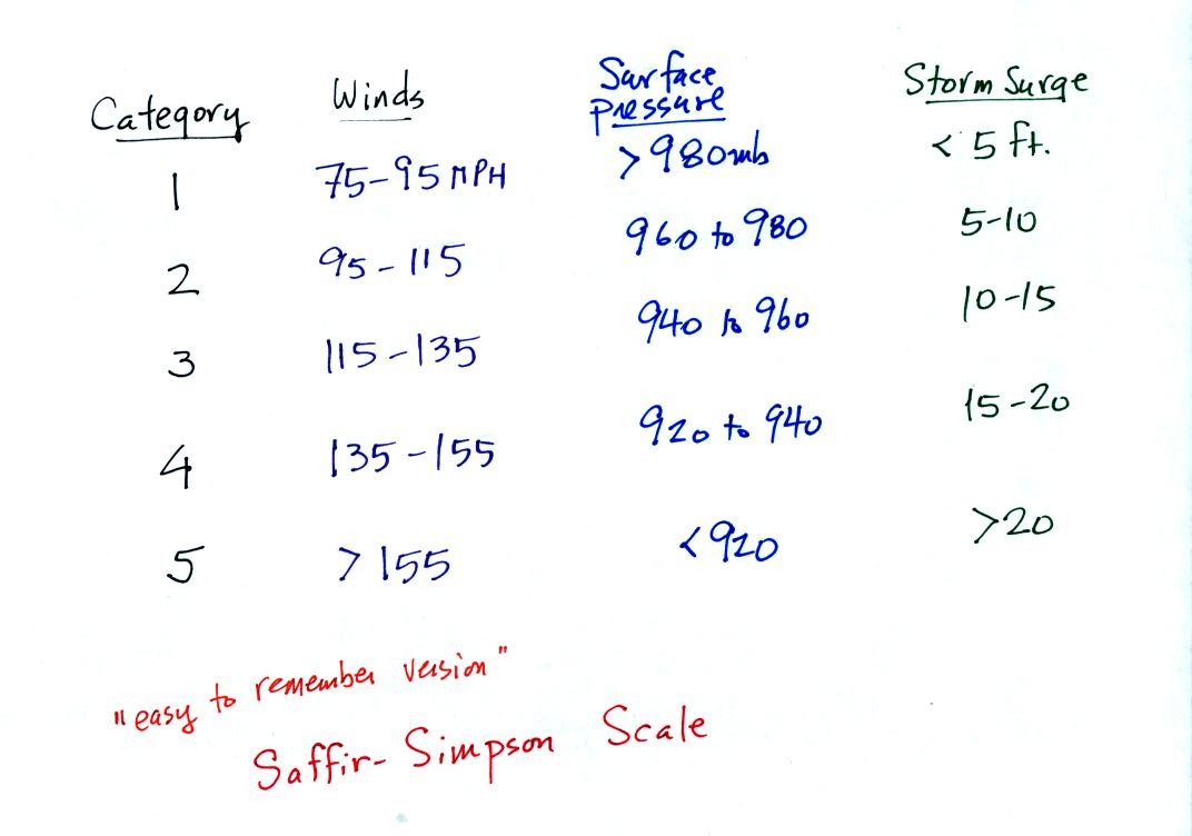
Here is an easy to remember version of the Saffir Simpson
scale used to
classify hurricane strength and damage potential.
If you remember that winds must be 75 MPH or higher in order for a
tropical cyclone to be a hurricane. In this easy to remember
scale the winds increase by 20 MPH as you move up the scale.
Pressures decrease in 20 mb increments (start at 1000 mb and go down
from there) and the height of the storm
surge increases by 5 feet. It is thought that parts of the
Louisianna and Mississippi coasts were hit with a 30 ft. storm surge as
Hurricane Katrina moved onshore last year.
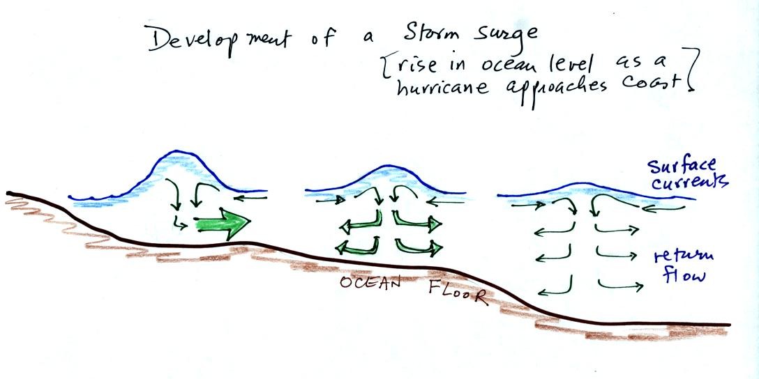
Out at sea, the converging surface winds create surface currents
in the
ocean that transport water toward the center of the hurricane.
The rise in ocean level is probably only a few feet, though the waves
are much larger. A return flow develops underwater that carries
the water back to where it came from.
As the hurricane approaches shore, the ocean becomes shallower.
The return flow must pass through a more restricted space. A rise
in ocean level will increase the underwater pressure and the return
flow will speed up. More pressure and an even faster return flow
is needed as the hurricane gets near the coast.
Here is a link to the storm surge website
(from the Hurricane Research Division of the Atlantic Oceanographic and
Meteorological Labororatory). It has an interesting animation
showing output from the SLOSH model used to predict hurricane storm
surges.
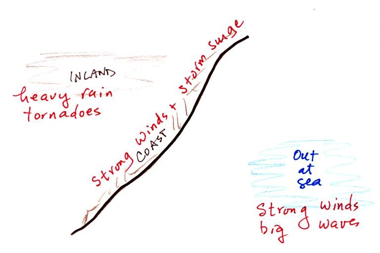
Hurricanes can, of course, be very destructive. Out at
sea the
main hazards are the strong winds and the large waves. The
Perfect Storm by Sebastian Junger describes the sinking of the Andrea
Gail in a strong hurricane like storm in October 1991. The exact
fate of the fishing ship is not known but it may have been turned end
over end by a large wave (pitch poled). Large waves can also
flood a ship and begin to fill it with water.
Along a coast the greatest threat is from the hurricane winds and the
storm surge. Large waves are superimposed on the storm surge.
The hurricanes winds slow quickly as it moves onshore, though
tornadoes may form. The biggest threat is from flooding.
Hurricanes can easily drop a foot or more of rain on an area as they
pass through.
Some of
the record setting values listed on p. 145 in the photocopied
notes are now going to have to be changed. Hurricane GILBERT
(1988) no longer holds the record for the lowest sea level surface
pressure reading in the Atlantic. That record now belongs to
Hurricane WILMA (882 mb). Peak winds in Hurricane Wilma reached
185 MPH.
Hurricane ANDREW (1992) is no longer the most expensive natural
disaster in US history. That record now belongs to Hurricane
KATRINA and is up to about $75B over three times that of Andrew.
The 1900 Galveston hurricane still remains the deadliest natural
disaster in US history. Hurricane MITCH remains the deadliest
hurricane in the N. Atlantic in over 200 years. More than 20,000
people are now thought to have been killed in Central America during
Hurricane MITCH.