Fri., Apr. 28

There is enough time left this semester for one more optional assignment.  It will be due in class next Wednesday, May 3.  You will find answers to almost all of the questions on the assignment in the Apr. 28 and May 1 online notes.  What is the "summertime reading suggestions" section at the bottom of the Optional Assignment page all about?


Now onto hurricanes.  You'll find the following sketch comparing a middle latitude storm and a hurricane on p. 141 in the photocopied notes.

Some of the similarities and differences (mostly differences) between these two storms are noted in this table
Differences
Similarities
  Differences 
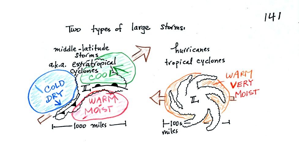
Found at middle latitudes (30 to 60 latitude)
Can form over land or water
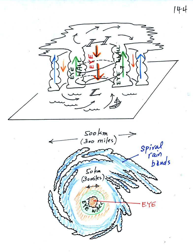
The term cyclone refers to winds spinning around low pressure,
both storms have low pressure centers (the low pressure becomes high pressure at the top of a hurricane)
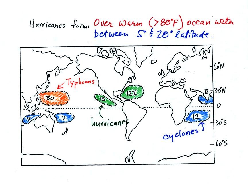
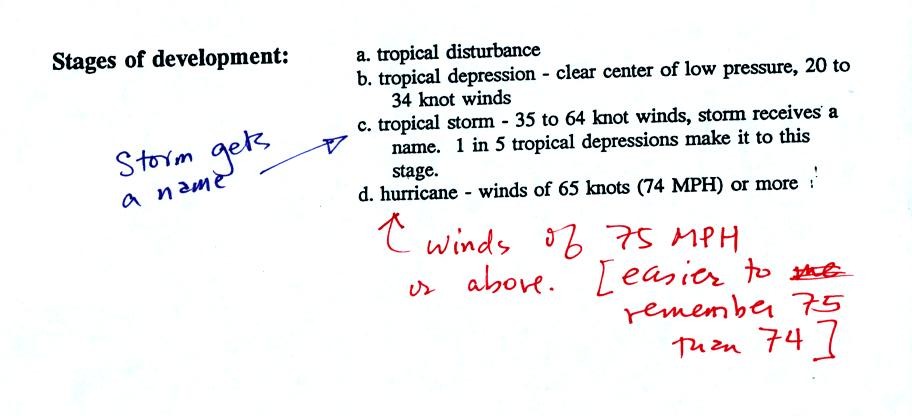
Found in the tropics (5 to 20 latitude)
Only form over warm ocean water
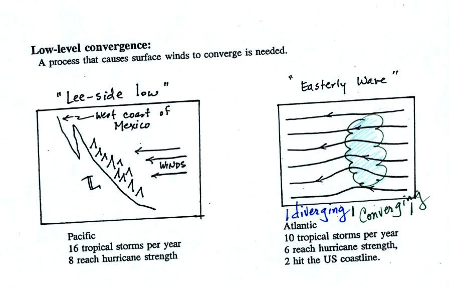
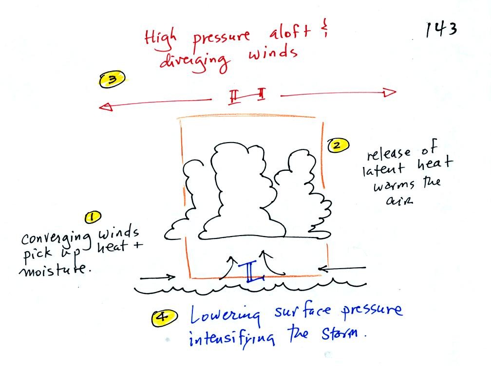
Movement is from west to east Upper level divergence cause lower the surface pressure
and cause both types of storms to intensity
Movement is from east to west
Warm and cold air masses brought together by converging winds
Warm moist air mass only
Storm winds intensify with altitude

Storm winds weaken with altitude
Strongest storms usually occur in the winter

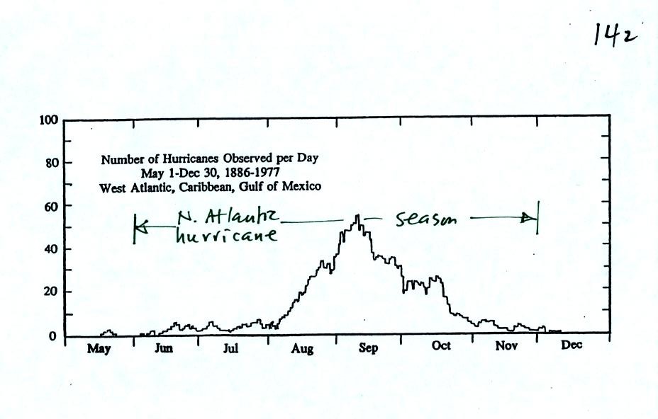
Strongest storms in the last summer to early fall


Hurricanes form over warm ocean water.  The warm layer of water must be fairly deep to contain enough energy to fuel a hurricane and in order that mixing doesn't bring cold water up to the ocean surface.  The atmosphere must be unstable so that thunderstorms can develop.  Hurricanes will only form when there is very little or no vertical wind shear (changing wind direction or speed with altitude).  Hurricanes don't form at the equator because there is no Coriolis force there. 

The figure above shows the relative frequency of tropical cyclone development in different parts of the world. 
The name hurricane, cyclone, and typhoon all refer to the same type of storm.  In most years the ocean off the coast of SE Asia is the world's most active hurricane zone.  Hurricanes are very rare off the east and west coasts of South America.

Note that more tropical cyclones form off the west coast of the US than off the east coast.  The west coast hurricanes don't generally get the same attention as they move away from the coast and usually don't present a threat to the US.


This figure shows when hurricanes are most common in the Atlantic.  Hurricane season in the Atlantic officially runs from June 1 through to November 30.  The peak of hurricane season is in September.  Hurricane season in the Pacific begins on May 15 and runs through Nov. 30.


Some kind of meteorological process that produces low level convergence is needed to initiate a hurricane.  One possibility, and the one that fuels most of the strong N. Atlantic hurricanes, is an "easterly wave."  This is just a "wiggle" in the wind flow pattern.  Easterly waves often form over Africa or just off the African coast and then travel toward the west across the N. Atlantic.  Winds converge as they approach the wave and then divergence once they are past it.  The convergence will cause air to rise and thunderstorms to begin to develop. 

In some ways winds blowing through an easterly wave resembles traffic on a multi lane highway.  Traffic will back up as it approaches a section of the highway with a closed lane.  Once through the "bottleneck" traffic will begin to flow more freely.

In an average year, in the N. Atlantic, there will be 10 named storms (tropical storms or hurricanes) that develop during hurricane season.  2005 was, of course, a very unusual year.  There were 28 named storms in the N. Atlantic in 2005.  That beat the previous record of 21 names storms that had been set in 1933.  Of the 28 named storms, 15 developed into hurricanes.

Winds blowing over mountains on the west coast of Mexico will sometimes form a surface low.  Note there are generally a few more tropical storms and hurricanes in the E. Pacific than in the N. Atlantic.  They generally move away from the US coast, though the Hawaiian Islands are sometimes affected.

The next figure shows what can happen next when thunderstorms start to form together in a group and atmospheric conditions are right.

1.  Surface winds converging into the center of the hurricane pick up heat and moisture from the ocean.  These are the two mains sources of energy for the hurricane.

2.   Rising air cools and thunderstorm clouds form.  The release of latent heat during condensation warms the atmosphere.  The core of a hurricane is warm.

3.   Pressure decreases more slowly with increasing altitude in the warm core of the hurricane.  The result is that pressure at the top center of the hurricane is higher than the pressure further out from the hurricane.  Upper levels winds diverge and spiral outward from the top center of the hurricane.

4.   The upper level divergence causes the surface pressure to decrease.  The speed of the converging surface winds increases and the storm intensifies.


A crossectional view of a mature hurricane and a picture like you might see on a satellite photograph. 

Sinking air in the very center of a hurricane produces the clear skies of the eye, a hurricane's most distinctive feature.  The eye is typically a few 10s of miles across, though it may only be a few miles across in the strongest hurricanes. 

A ring of strong thunderstorms, the eye wall, surrounds the eye.  This is where the hurricane's strongest winds are found. 

Additional concentric rings of thunderstorms are found as you move outward from the center of the hurricane.  These are called rain bands.