Mon., Apr. 17, 2006
Reports turned in last week have been graded. Revisions are due
in two weeks on Mon. May 1 (the next to the last day of classes).
The most recent optional assignment has been graded. If you
answered all of the questions (correctly or incorrectly it didn't
matter) and turned the assignment in on time you received full credit
(it would have been too difficult and time consuming an assignment to
grade). You can find an online version of the assignment here and the answers to the
assignment questions here.
A preliminary version of the Quiz #4 Study
Guide is now available online. It is likely to change
slightly over the next few days.
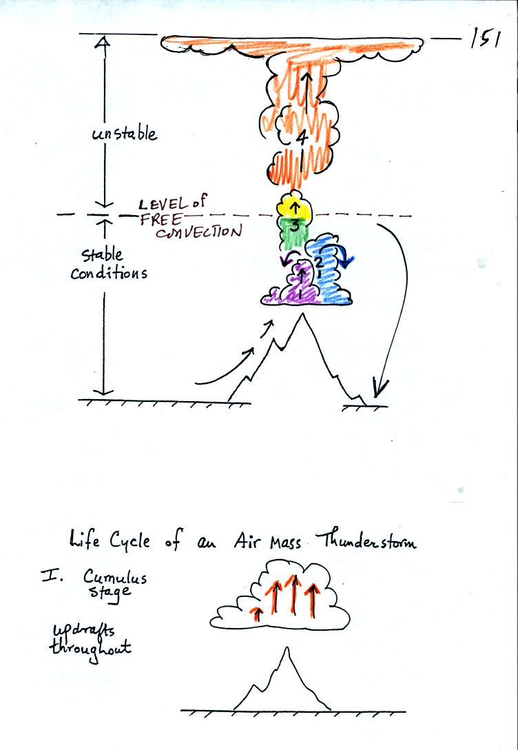
The top portion of this figure repeats what was discussed in
class last Friday. It takes some effort and often a good part of
the
day before a thunderstorm forms. Early in the day air is lifted
and released. The air finds itself colder and denser than the
surrounding air and sinks back to where it started from. As the
day goes on the air is lifted higher and higher. If the air is
lifted above the "level of free convection" the air parcel will find
itself warmer and less dense than the surrounding air and will continue
to float upward on its own. This is really the beginning of a
thunderstorm.
An ordinary single cell
thunderstorm goes through a 3-stage life cycle. In
the first stage, the cumulus stage, you would find updrafts throughout
the inside of the cloud.
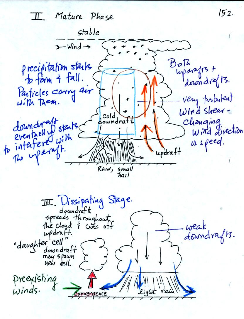
Once precipitation has formed and grown to a certain size,
it will
begin to fall and drag air downward with it. This is the
beginning of the
mature stage where you find both an updraft and a downdraft inside the
cloud. The falling precipitation will also pull in dry air from
outside the thunderstorm (this is called entrainment).
Precipitation will mix with this drier air and evaporate. The
evaporation will strengthen the downdraft (the
evaporation cools the air and makes it more dense). The
thunderstorm is strongest in the mature stage.
Eventually the downdraft spreads throughout the inside of the cloud and
interferes with or cuts off the updraft. This marks the beginning
of the end for this thunderstorm. In the dissipating stage you
would find just weak downodrafts throughout the interior of the cloud.
Note how the winds from one thunderstorm can cause a region of
convergence on one side of the original storm and can lead to the
development of new storms. Preexisting winds refers to winds that
were blowing before the thunderstorm even formed.
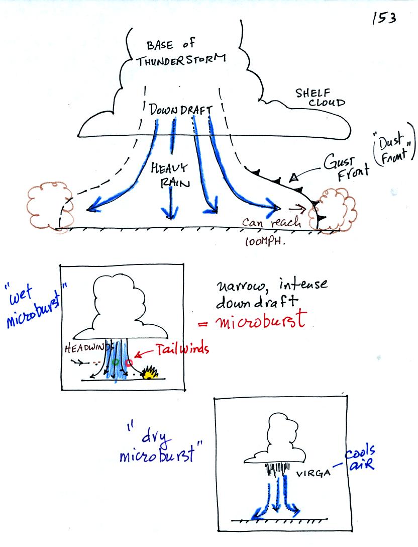
We have talked about most of the features in the top picture
before. The dust storms that thunderstorms stir up can cause a
sudden drop in visibility and are a serious risk to automobile traffic
on the interstate highway.
A narrow intense downdraft is called a microburst. At the ground
microburst winds will sometimes reach 100 MPH (over a limited area);
most tornadoes have winds of 100
MPH or less. Microburst winds can damage homes, uproot trees and
will sometimes blow over a line of electric power poles usually at
least once during our summer thunderstorm season. Microbursts are
a serious threat to aircraft especially when they are close to the
ground during landing or takeoff (see Fig. 10.10 in the text).
Falling rain could warn of a (wet)
microburst.
In other cases, dangerous (dry) microburst winds might be invisible
(the virga, evaporating rain, will cool the air, make the air more
dense, and the downdraft winds will strengthen).
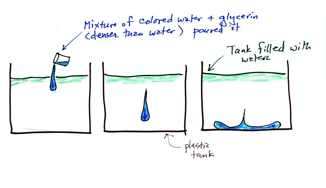
A simple demonstration gives you an idea of what a
microburst
might look like. A large plastic tank is filled with water, the
water
represents air in the atmosphere. Then some colored liquid that
is a
little denser than water is poured into the tank. This represents
the
cold dense air in a thunderstorm downdraft. The colored liquid
sinks
to the bottom of the tank and then spreads out horizontally. In
the
atmosphere the cold downdraft air hits the ground and spreads out
horizontally. These are the strong microburst winds that can
reach 100
MPH.
The demonstration was followed with a short time lapse video showing a
microburst that occured over the Santa Catalina mountains. Cold
air
and rain suddenly fell out of a thunderstorm sank to the ground and
then spread out sideways. The surface winds could well have been
strong enough to blow down a tree or two.
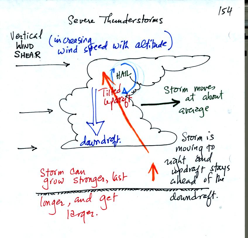
Note how the winds are increasing in speed with increasing
altitude. This is vertical wind shear (changing wind direction
with altitude is also wind shear).
The thunderstorm is moving more quickly to the right than the air
next to the ground. The thunderstorm will move to the right more
rapidly than the air in the thunderstorm updraft which originates at
the ground. Rising air that is situated at the front bottom edge
of the thunderstorm will find itself at the back edge of the storm when
it reaches the top of the cloud. This produces a tilted
updraft.
Remember that an ordinary air mass thunderstorm will begin to dissipate
when the downdraft grows horizontally and cuts off the updraft.
In a severe storm the updraft is continually
moving to the right and staying out of the downdraft's way.
Severe thunderstorms can get bigger, stronger, and last longer than
ordinary air mass thunderstorms.
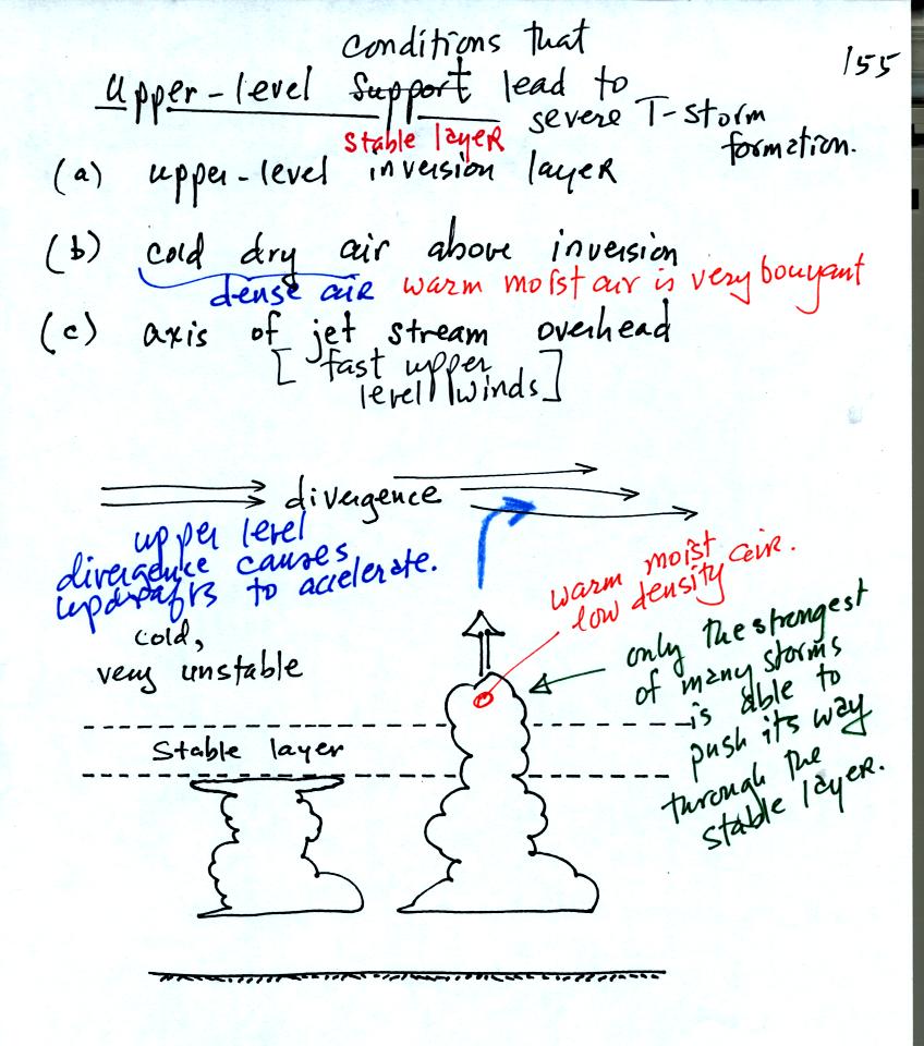
Here are some of the atmospheric conditions that favor development of a
severe thunderstorm. You wouldn't think that an upper level
inversion layer would favor thunderstorm development because
thunderstorms form when the atmosphere is unstable. What the
inversion layer does is prevent a lot of realtively weak thunderstorms
from forming. Instead only a few stronger than average
thunderstorms have enough upward momentum to push through the inversion
layer. Once through the inversion they encounter dense cold dry
air. The thunderstorm air finds it is very bouyant and explodes
upward. The development is also aided by upper level divergence
caused by a jet stream (a band of fast upper level winds). This
could act to strengthen the thunderstorm updraft.