The atmosphere and the weather
![[Home]](../../icons/home.jpg)
![[Lectures]](../../icons/lectures.jpg)
![[Previous]](../../icons/previous.jpg)
![[Next]](../../icons/next.jpg)
Stability of the atmosphere
Most clouds form as air rises and cools.
There are several mechanisms that force surface air
to rise.
Let's assume that we are in a region of the atmosphere where
the surface air is being forced to rise upward.
This page explains the concept of atmospheric stability
and how it influences the size and shapes of clouds. An important
reason for discussing atmospheric stability is that thunderstorms, tornadoes,
and hurricanes form when the atmosphere is unstable. The more unstable
the atmosphere, the higher the potential for severe weather. There are two
general types of clouds:
- Stratiform-type clouds
- vertically thin layers of cloud that often cover large
horizontal areas
- tend to from in stable environmental conditions
- Cumuliform-type clouds
- vertically tall clouds, but horizontally not that large,
often see clear sky between cloud elements
- tend to form in unstable environmental conditions
Figures drawn in class should help you to understand the differences
between these general cloud types.
What makes the atmosphere unstable?
If the temperature of a lifted parcel becomes warmer than the surrounding
envrionmental air, it becomes buoyant, and accelerates upward. In other
words, the parcel weighs less than the surrounding air, so it rises upward
on its own, without being pushed. This is similar to what happens if you
place a ball filled with air at the bottom of a pool of water and let it go.
The ball will move upward because it is less dense than the surrounding fluid.
Parcels which are warmer than the environmental air surrounding them are
less dense than the surrounding fluid and rise upward. This can be easily
shown using the gas law. Recall that parcels in the atmosphere adjust their size
so that the air pressure inside the parcel equals the air pressure outside the parcel (This
is always the case). If the air temperature inside a parcel is warmer than the air
temperature of the air surrounding the parcel, the number density inside the parcel is lower
than the number density outside the parcel. Thus, the air parcel weighs less than an equal
volume of air outside the parcel and it will rise upward.
In the atmosphere, other than surface heating and free convection,
the only way in which parcels become unstable is when
the latent heat released during cloud formation (water vapor condensing
to liquid cloud droplets) is enough to make the
temperature of the parcel warmer than the surrounding environmental air.
Meteorologists assess and compute the stability of the atmosphere by lifting hypothetical
parcels of air upward from the surface and comparing the parcel temperature
with the temperature of the surrounding air. The temperature of the surrounding
air from ground level upward is measured twice each day by releasing weather
balloons with instruments attached.
In this class, we will illustrate the concepts of cloud formation and
stability using simplified numerical examples. The basic problem will be
given the vertical temperature structure of the atmosphere and the water
vapor content of air at the surface, lift a hypothetical parcel upward
to determine (a) at what altitude will a cloud start to form and (b) at
what altitude, if at all, will the parcel become unstable.
Recall the rules we already discussed for lifting air parcels:
- The starting temperature and water vapor content (use the dew point) of
the parcel is taken to be the measured conditions at ground level. You will
always be given this information.
- As long as the parcel is unsaturated (relative humidity < 100% or whenever the dew point
temperature of the parcel less than the temperature of the parcel), the rate of cooling
is 10°C for every 1000 meters the parcel is lifted.
- As a rising parcel cools, its relative humidity increases. Once the relative
humidity reaches 100% (determined when the parcel temperature cools down to its
original dew point temperature), further lifting (and cooling) results in net
condensation, forming a cloud. Since condensation releases latent heat within the
parcel, the rate of cooling is slower. Parcels which are saturated cool at a rate
of 6°C for every 1000 meters the parcel is lifted. Also keep in mind that once
a cloud begins to develop in a parcel, just enough water vapor will condense into
liquid water so that the air in the parcel remains saturated (relative humidity = 100%
and the dew point temperature equals the air temperature inside the parcel).
Now we add the concept of stability.
To determine stability, compare the parcel temperature with the temperature of
the surrounding air and think about what would happen if the parcel was "let go".
- If the parcel temperature is higher than the surrounding air temperature, the
parcel is positively buoyant and would tend to move upward if released. This is
the unstable situation. The atmosphere is said to be unstable when a lifted parcel
reaches a region where it accelerates upward because it has become less dense than
the surrounding atmosphere, i.e., push a parcel up and
it shoots upward on its own.
- If the parcel temperature is lower than the surrounding air temperature, the
parcel is negatively buoyant and would tend to move downward if released. This
is a stable situation. The atmosphere is said to be stable when a lifted parcel
is more dense than the surrounding atmosphere, i.e., push a parcel up and
it tends to come back down
- If the parcel temperature is equal to the surrounding air temperature, the
parcel is said to be neutral and would remain stationary if released. When a
parcel becomes neutral, it often signals a transition from stable to unstable or
unstable to stable.
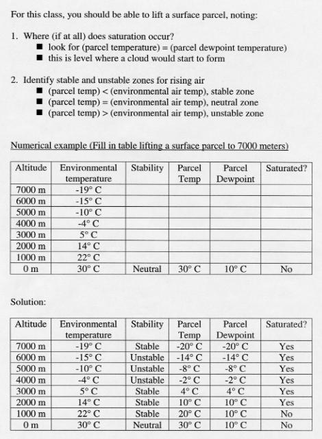
Numerical example for computing stability
Lets look at a numerical example. The first table shows you what you would know
about the atmosphere before performing the stability analysis. You would have to fill
in the blanks. The second table shows the solution. We will go over the solution
in detail during class. Click Here to view the example.
Some notes on Predicting Violent Storms
Meteorologists use a similar method to assess the potential for thunderstorms and severe
weather:
- Lift parcels upward to see if they become unstable. This must be done for the current
measured atmospheric conditions as well as for forecasted conditions in the future.
- The more unstable the atmosphere, the greater the potential for violent storms
- The depth of the unstable layer is important.
- The greater the positive difference between the parcel temperature and the
surrounding air temperature, the more unstable the atmosphere.
- Question to answer. If the atmosphere is unstable, will parcels be lifted high enough
(by one of the four mechanisms listed on the previous page) to reach the unstable layer?
This must occur to "release the instability" if storms are to occur.