![]()
![]()
![]()
![]()
Most clouds form as air rises, expands and cools. But why does the air rise on some occasions and not on others? And why does the size and shape of clouds vary so much when the air does rise? The answer to the latter question is related to the concept of atmospheric stability, which we will discuss in later lectures. We will now discuss some of the mechanisms responsible for getting air to rise in the first place. The reason for identifying places where air is forced to rise upward is that interesting and important weather is usually associated with rising air because this is where clouds and precipitation happen.
Four basic mechanisms that force air to move upward (rise)
![[convection]](cnvct1.gif) During the daytime, the
earth's surface is heated by the sun, which in turn heats the air in contact
with the surface. However, the surface of the Earth is not heated evenly by the Sun. Some
surfaces better absorb radiation from the sun and become warmer than surrounding surfaces, e.g.,
a blacktop surface will typically become warmer than a grass covered surface or a rocky surface
will typically be warmer than wet soil.
Parcels (or bubbles) of hot air form above these "hot spots" on the surface and begin to
rise upward (sometimes called thermals). As they rise upward, the thermals cool by expansion. These warmed parcels
continue to rise as long as they remain warmer than the air surrounding them.
Early in the day (morning), the parcels don't rise very high because they quickly
become colder than the surrounding air. As the day goes on, a deeper and deeper layer
of air near the ground warms up. Parcels get hotter as the ground temperature
increases and are able to rise higher and higher as the day progresses. If
a thermal is able to rise high enough
to cool to its saturation point, then some of the water vapor within the rising
parcel condenses and
becomes visible as a cloud.
During the daytime, the
earth's surface is heated by the sun, which in turn heats the air in contact
with the surface. However, the surface of the Earth is not heated evenly by the Sun. Some
surfaces better absorb radiation from the sun and become warmer than surrounding surfaces, e.g.,
a blacktop surface will typically become warmer than a grass covered surface or a rocky surface
will typically be warmer than wet soil.
Parcels (or bubbles) of hot air form above these "hot spots" on the surface and begin to
rise upward (sometimes called thermals). As they rise upward, the thermals cool by expansion. These warmed parcels
continue to rise as long as they remain warmer than the air surrounding them.
Early in the day (morning), the parcels don't rise very high because they quickly
become colder than the surrounding air. As the day goes on, a deeper and deeper layer
of air near the ground warms up. Parcels get hotter as the ground temperature
increases and are able to rise higher and higher as the day progresses. If
a thermal is able to rise high enough
to cool to its saturation point, then some of the water vapor within the rising
parcel condenses and
becomes visible as a cloud.
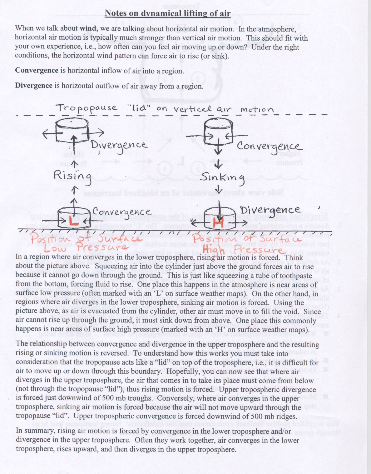
![[convergence]](cnvrg1.gif) Convergence is an atmospheric condition that exists when there is
a horizontal net inflow of air into a region. When air converges
along the earth's surface, it is forced to rise since it cannot go
downward. Large scale convergence can lift a layer of air
hundreds of kilometers across. Surface low pressure regions (marked by
L's on surface weather maps), are areas where surface convergence and forced rising air
takes place.
Convergence is an atmospheric condition that exists when there is
a horizontal net inflow of air into a region. When air converges
along the earth's surface, it is forced to rise since it cannot go
downward. Large scale convergence can lift a layer of air
hundreds of kilometers across. Surface low pressure regions (marked by
L's on surface weather maps), are areas where surface convergence and forced rising air
takes place.
Divergence is an atmospheric condition that exists when there is a horizontal net outflow of air from a region. When air diverges just below the top of the troposphere, air from below is forced to rise up and take its place. You can think of the tropopause as a "lid" or boundary that does not allow air to move up or down through it. Weather reporters often use the terms "upper-level disturbance" or "upper-level energy" to indicate regions where the rising air motion is forced by the atmospheric conditions 5-10 km above the Earth's surface. One place where upper tropospheric divergences leads to rising air is just downstream of 500 mb troughs. That topic will be covered when we revisit 500 mb maps later in the semester.
These types of forced rising air motion are often called "dynamical lifting" because the rising air is forced due to the dynamics or movement or pattern of the horizontal air flow. You may wish to review this document on dynamical lifting of air , which was originally used in a previous reading page.
![[orographic lifting]](org1.gif) When air moving along the surface of the Earth is confronted by a mountain, it is forced up and over the
mountain, cooling as it rises. If the air cools to its saturation
point, the water vapor condenses and a cloud forms. Heating of the
mountain slopes by the Sun also causes air to rise upward through the process of surface heating and
free convection described above.
These types of clouds are called "orographic clouds", which
develop in response to lifting forced by the topography of the
earth.
When air moving along the surface of the Earth is confronted by a mountain, it is forced up and over the
mountain, cooling as it rises. If the air cools to its saturation
point, the water vapor condenses and a cloud forms. Heating of the
mountain slopes by the Sun also causes air to rise upward through the process of surface heating and
free convection described above.
These types of clouds are called "orographic clouds", which
develop in response to lifting forced by the topography of the
earth.
While air on the windward side of a mountain is forced to rise, often resulting in clouds and precipitation, the air on the leeward side of a mountain is forced to sink. Thus on the leeward side of a mountain, we often see clear skies and warm, dry conditions. The leeward side of a mountain range is often called a "rain shadow" region because clouds and precipitation do not form where air is sinking. The great basin area of the United States is a rain shadow region.
![[front]](front_lifting.gif)
A front is defined as the transition zone between two air masses of different density. The warmer air mass is less dense than the colder air mass. Fronts extend not only in the horizontal direction, but in the vertical as well. Therefore, when referring to the frontal surface (or frontal zone), we are referring to both the horizontal and vertical components of the front. All fronts slope in the vertical so that the warmer (less dense) air mass sits on top of the colder (more dense) air mass. In other words, the warmer air mass is forced to rise over the colder air mass. As air from the warm air mass rises, it cools, leading to the development of clouds and maybe precipitation.
Large areas of clouds and precipitation are common near weather fronts. Weather fronts can sometimes extend along lines that are more than a thousand kilometers long. If the atmosphere is stable, a large area of clouds and steady precipitation is common. But if the atmosphere is unstable, numerous thunderstorms (sometimes severe) may be observed near weather fronts. We will discuss the concept of atmospheric stability soon.
![]()
![]()
![]()
![]()