Web Links for ATMO 170A1 - Section 1
Chapter 10
Time lapse of thunderstorm development along sea breeze
Gust fronts and
haboobs:
Same dust storm, different view
Phoenix dust storm 2014 time lapse
Microbursts:
Delta Airlines Flight 191 (August 2, 1985 microburst event and crash)
Lightning:
Negative cloud-to-ground lightning flash
Lightning from volcano ash plume
Video of stepped leader [1] [2]
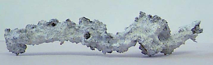
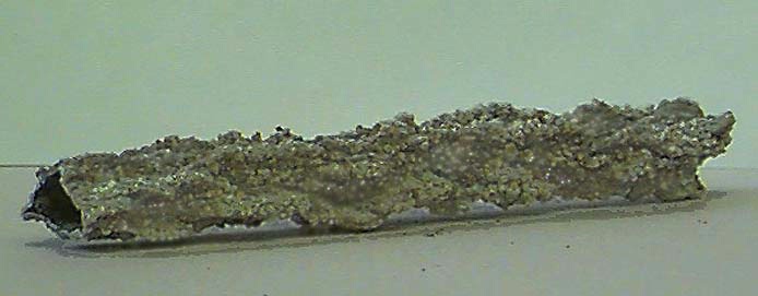
Fulgurites [1] [2] (source: Univ. of Florida)
Weather radar:
1. Doppler radar overview (NWS Billings)
2. Doppler radar velocity (NWS Billings)
3. Moore, OK (May 20 2013), tornado radar loop
RKW:
Supercells and
tornadoes:
4. Tornado environments and overview (NOVA Tornado! 1985; start at ~7:00 mark)
5. Severe weather climatology (SPC)
6. Joplin, MO, tornado of May 22 2011
7. March 18 1925 Tri-State tornado reanalysis [1] [2]
8. How supercells are able to rotate (NOVA Tornado! 1985; start at 2:53 mark and play through 5:12 mark)
9. Flow in simulated supercell thunderstorm (The Enemy Wind; play through 2:20 mark)
10. May 15 1991 Laverne, OK, tornado (almost full life cycle)
12. Tornado damage on surveillance
13. Pampa, Texas, tornado (Tornado Video Classics III; start at 22:47 mark, end at 26:52 mark)
14. Multiple vortices (Tornado Video Classics I; start at 16:05 mark, end at 19:42 mark)
15. Inside Mega Tornado (National Geographic)
16. Leigh Orf's SLS 2014 presentation