Tuesday Nov. 17, 2015
French music before class today Francesca Blanchard "Le Blues
(live on Vermont Public Radio)", Zaz a Montmartre "Les
Passants", Vanessa Paradis & Benjamin Biolay "Le Rempart",
Zaz & Pablo Alboran "Sous le Ciel
de Paris"
The Experiment #2 revised reports, Book, and Scientific Paper
reports have all been graded. You can revise these Book,
Scientific Paper, and experiment reports (turned in last Tuesday)
if you want to (it's not required). The revised reports are
due Tue., Dec. 1. Please return your original report with
your revised report.
The 1S1P reports on Fog have also been "graded" and
were returned today also (everyone received full credit on their
report) .
An Optional Assignment handed out a week ago (forces and winds)
was collected today. You'll find answers to the questions here.
The Atmospheric Stability assignment is due Thursday this week
(you can earn either 1S1P pts or extra credit). There are
two new assignments due next Tuesday (Nov. 24). On the
Thermal Circulation/3_cell model assignment you can earn 1S1P pts,
extra credit, or both. You can only earn 1S1P points on the
Foucault Pendulum assignment. See the main class webpage for
more details and links to the assignments.
The toilet flushing experiment couldn't have turned out
better. Here
are the results
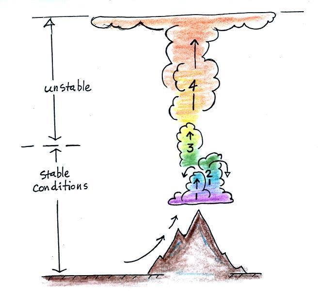
Air mass thunderstorm life cycle
The events leading up to the initiation of a summer air
mass thunderstorm are summarized in the figure
below. It takes some
effort and often a good part of the day before a thunderstorm
forms. The air must be lifted to just above the level of
free convection (the dotted line at middle left in the
picture). Once air is lifted above the level of free
convection it finds itself warmer and less dense that the air
around it and floats upward on its own. I've tried to show this with colors below.
Cool colors below the level of free convection because the air
in the lifted parcel is colder and denser than its
surroundings. Warm colors above the dotted line indicate
parcel air that is warmer and less dense than the
surroundings. Once the parcel is lifted above the level
of free convection it becomes buoyant; this is the
moment at which the air mass thunderstorm begins.
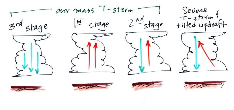
Once an air mass
thunderstorm gets above the level of free convection it goes
through a 3-stage life cycle
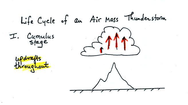
In
the first stage you would only find updrafts inside the cloud
(that's all you need to know about this stage, you don't even
need to remember the name of the stage).
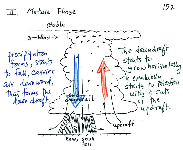
Once precipitation has formed and grown to a certain size, it
will begin to fall and drag air downward with it. This
is the beginning of the mature stage where you find both an
updraft and a downdraft inside the cloud. The falling
precipitation will also pull in dry air from outside the
thunderstorm (this is called entrainment). Precipitation
will mix with this drier air and evaporate. The
evaporation will strengthen the downdraft (the evaporation
cools the air and makes it denser).
The thunderstorm is strongest in the mature stage. This
is when the heaviest rain, hail, strongest winds, and most of
the lightning occur.
Eventually the downdraft spreads
horizontally throughout the inside of the cloud and begins to
interfere with the updraft. This marks the beginning of
the end for this thunderstorm.
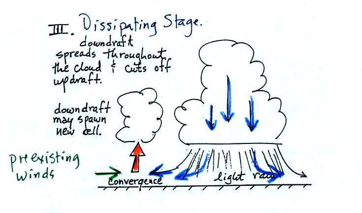
The downdraft
eventually fills the interior of the cloud. In this
dissipating stage you would only find weak downdrafts
throughout the cloud.
Note how the winds from one
thunderstorm can cause a region of convergence on one side of
the original storm and can lead to the development of new
storms. Preexisting winds refers to winds that were
blowing before the thunderstorm formed. Convergence
between the prexisting and the thunderstorm downdraft winds
creates rising air that can initiate a new thunderstorm.
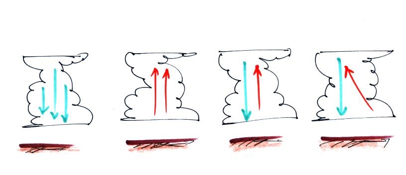
Here's a sketch of 4 thunderstorm clouds, what
information could you add to each picture.
You should be able to say something about the first
three. The 4th cloud might be a bit of a puzzle.
You'll find the answer to the question at the end of today's
notes.
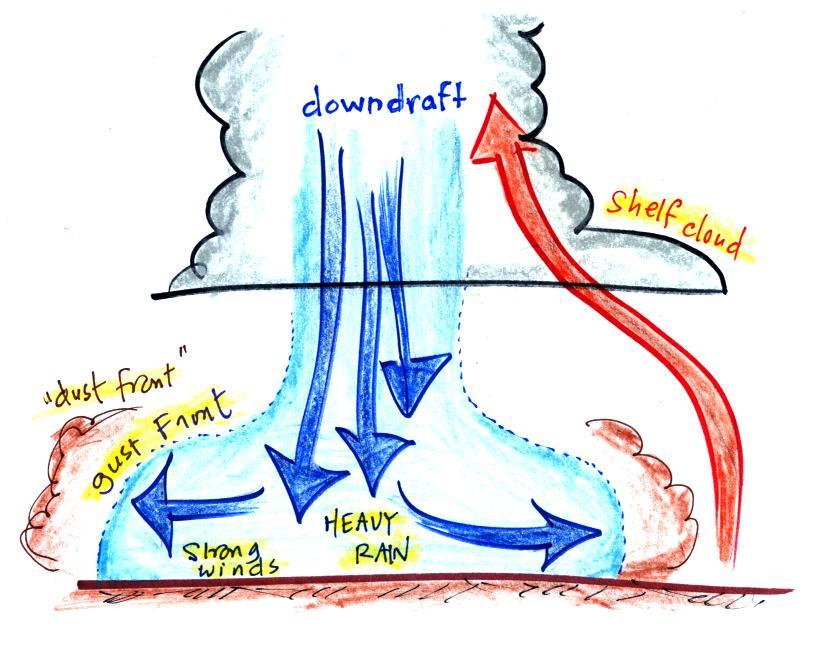
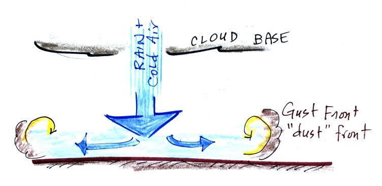
Gust fronts and the dust storms (haboobs) they can
produce
The picture below shows some of the features at the base of a
thunderstorm.
The cold downdraft air spilling out of
a thunderstorm hits the ground and begins to move outward from underneath the thunderstorm. The
leading edge of this outward moving air is called a gust
front. You can think of it as a dust front
because the gust front winds often stir up a lot of dust here in
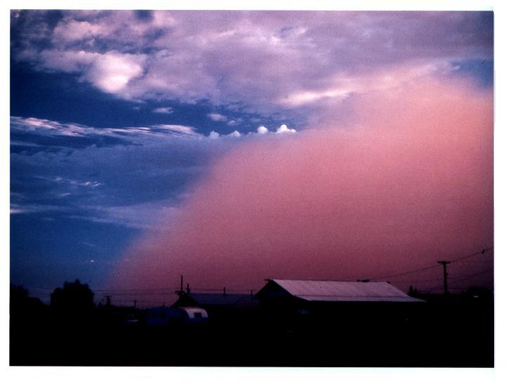
the desert southwest (see below). There are
several very nice examples in Mike
Olbinski's Storm Gallery.
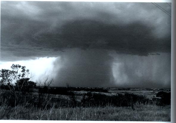
The gust front in this picture
(taken near Winslow,
Az) is moving from the right to the left.
Visibility in the dust cloud can drop to near zero which
makes this a serious
hazard to automobile traffic. Dust storms like this
are sometimes called "haboobs".
There's lots of video on YouTube of an impressive dust storm a
few summers ago. Here's an example
from Gilbert Arizona (July 5, 2011). You
can see day literally turn to night when the dust cloud is
overhead (start about 1:20). Here's another video of the same storm
from a different location (South Mountain). There are also
several time lapse videos on Mike
Olbinski's Time Lapse Gallery page.
Here's a video
from a summer 2012 dust storm captured from the front window
of a vehicle that drove through the storm. Check the last
minute or two of the video where visibility drops to near zero
(about 5:00 minutes into the video). Officials recommend
that you drive off the highway under conditions like this, turn
off your lights, and take your foot off the brake so that your
brake lights are not on (otherwise someone might follow your
lights thinking you're still on the highway and run into you from
behind).
Microbursts
Thunderstorm downdraft winds can be a serious hazard whether they
stir up dust or not.
A narrow intense
thunderstorm downdraft is called a microburst. At the
ground microburst winds will sometimes reach 100 MPH or more
(over a limited area). As we will see most tornadoes have
winds of 100 MPH or less. Microburst winds can damage
homes (especially mobile homes that aren't tied to the ground),
uproot trees, and seem to blow over a line of electric power
poles at some point every summer in Tucson. Wind damage from a microburst is
often incorrectly attributed to a tornado.
Microbursts
are a serious threat to aircraft especially when they are close
to the ground during landing or takeoff. Microburst
associated wind shear was largely responsible for the crash of Delta
Airlines Flight 191 while landing at the Dallas Fort Worth
airport on Aug. 2, 1985 (caution some of the links at the end of
the article contain audio of actual cockpit communications).
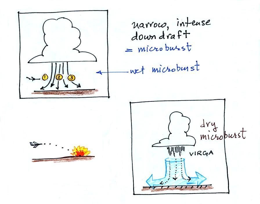
Falling rain could warn of a
wet microburst (see photo below). In other cases, dangerous dry microburst winds might be
invisible (the virga, evaporating
rain, will cool the air, make the air more dense, and strengthen
the downdraft winds).
Here are a couple of microburst
videos. The first video
was taken in the heavy rain and strong winds under a
thunderstorm in the microburst. You'll see a power pole
snapped in half by the microburst winds at about 2:26 into the
video. We'll look at portions of a 2nd longer
video in class. It was taken in or near San Tan,
Arizona. The microburst doesn't look too impressive at the
start of the footage but the storm winds soon get pretty violent
(at about the 3:15 point in the video) and blew over or uprooted
several trees (6:45 into the video).
Severe thunderstorms, wind shear, mesocyclones, and
wall clouds
Next I wanted to look at some of the conditions that can lead
to severe thunderstorm formation and some of the characteristics
of these storms. Severe thunderstorms last longer, grow
bigger, and become stronger than ordinary air mass
thunderstorms. They can also produce tornadoes.
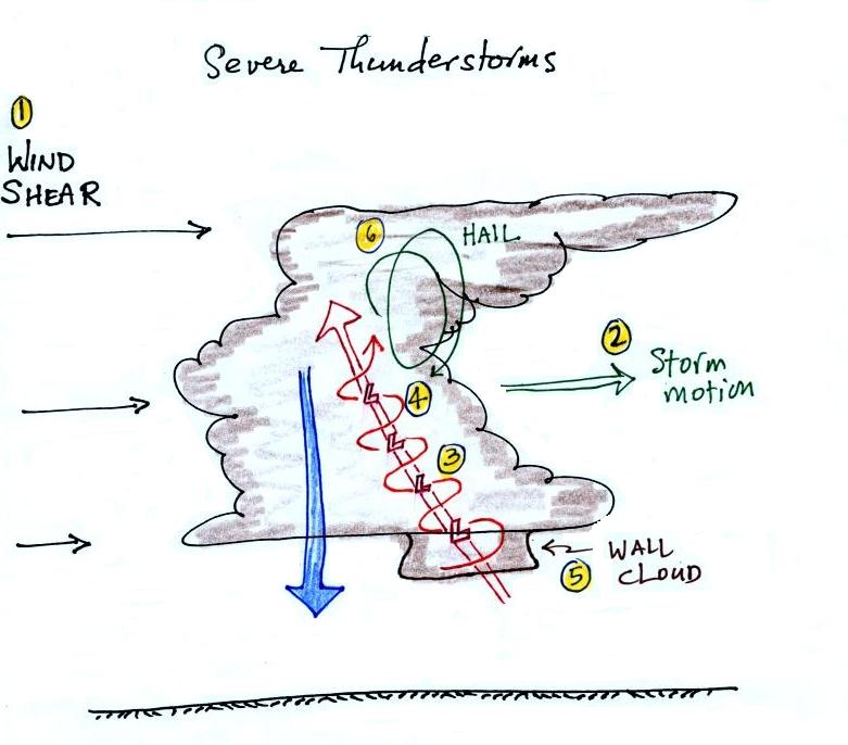
Severe storms are more likely to form
when there is vertical wind shear (the picture above is on p.
154a in the ClassNotes). Wind shear (Point 1)
is changing wind direction and/or wind speed with
distance. In the case shown above, the wind speed is
increasing with increasing altitude, this is vertical wind
shear.
A thunderstorm that forms in this kind of an environment will move at an average of
the speeds at the top and bottom of the cloud (Point 2). The
thunderstorm will move to the right more rapidly than the air
at the ground which is where the updraft begins. Rising
air that is situated at the front bottom edge of the
thunderstorm will find itself at the back edge of the storm
when it reaches the top of the cloud.
This produces a tilted updraft (Point 3). The downdraft
is situated at the back of the ground. The updraft is
continually moving to the right and staying away from the
downdraft. The updraft and downdraft coexist and do not
"get in each others way." If you remember in air mass
thunderstorms, the downdraft gets in the way of the updraft
and leads to dissipation of the storm.
Sometimes
the tilted updraft will begin to rotate. A rotating
updraft is called a mesocyclone (Point
4). Meso
refers to medium size (thunderstorm size) and cyclone means
winds spinning around low pressure (tornadoes are sometimes
called cyclones). Low pressure in the core of the mesocyclone creates an inward pointing
pressure gradient force needed to keep the updraft winds
spinning in circular path.
The cloud that extends below the cloud
base and surrounds the mesocyclone
is called a wall cloud
(Point 5). The
largest and strongest tornadoes will generally come from the
wall cloud.
Note (Point 6)
that a tilted updraft also provides a way of keeping growing
hailstones inside the cloud. Hailstones get carried up
toward the top of the cloud where they begin to fall. But they then fall back into the strong core
of the updraft and get carried back up toward the top of the
cloud.
Here is a link to an exceptional time lapse video
of a supercell thunderstorm in Texas (from Mike Olbinski).
Find the Supercell near Booker, Tx frame near the bottom of the
page. In time lapse you can see the rotation of the wall
cloud. If you watch closely you'll see another interesting
feature: moisture from air in the downdraft that reaches the
ground is drawn into the thunderstorm updraft (starting at about
0:38 in the video up until the end of the first segment of
video). As the downdraft air moves upward cloud begins to
form.
It is worth trying to understand why the wall cloud surrounds the
mesocyclone and why it extends below the rest of the cloud.
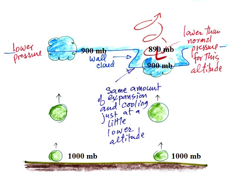
Air in the center of the rotating updraft has a little
lower pressure than the air surrounding it at the same
altitude. I've assumed that the pressure in the middle
of the mesocyclone at cloud base altitude is 890 mb. In
this part of the picture 900 mb pressure is found a little bit
closer to the ground. Thus air that rises into the
rotating updraft doesn't have to go as high before it
encounters 900 mb pressure and has expanded and cooled enough
to form a cloud.
Here's the answer to the question about thunderstorm features
embedded in today's notes:
Tornadoes
The
United States
has roughly
1000 tornadoes
in an average
year. The
US has more tornadoes than
any other country in the
world (~ 1000/year).
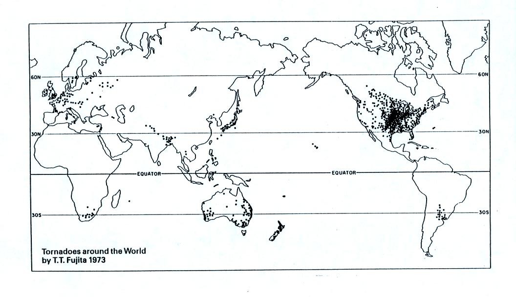
A
year's worth of tornado activity plotted
on a world map. Note the name at
bottom left: T.T. Fujita, "Mr.
Tornado." The scale used to rate
tornado strength and intensity is named
after him.
This is mostly just a
consequence of geography.
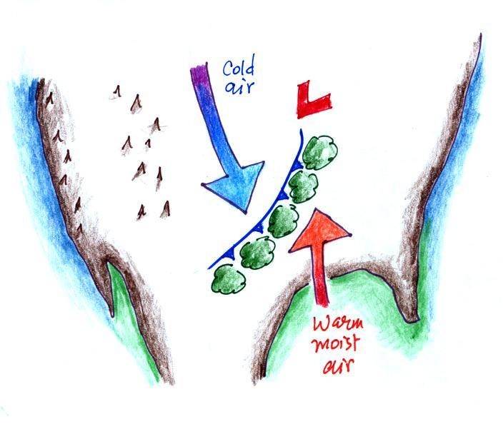
Without
any mountains in the way, cold dry air can
move in the spring all the way from Canada
to the Gulf Coast. There it collides
with warm moist air from the Gulf of Mexico
to form strong cold fronts and
thunderstorms. There are some other
meteorological conditions that come into
play that make these storms capable of
producing tornadoes.
Speaking of strong cold fronts, a strong
cold front moved through Arizona late Sunday
night into Monday morning. Some of the
coldest air since last winter has settled into
place and parts of Tucson and the surrounding
area were under a freeze warning last night
(happy to say my pepper plants are doing
OK). The map below shows the location of
the front on Monday at 1 pm.
Severe weather, flooding and tornadoes are also
possible.
Here's the upper level chart for the same
time. A deep (pronounced) trough in the cold air
behind the cold front.
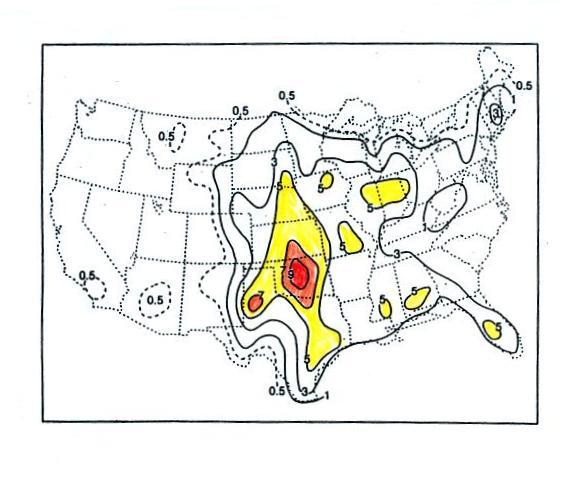
This map (found on p. 161 in the ClassNotes) shows
the average frequency of tornado occurrence in the
US. Tornadoes have been observed in every
state (including Alaska), but tornadoes are most
frequent in the Central Plains, a region
referred to as "Tornado Alley"
(highlighted in red, orange, and yellow
above).
Tornado characteristics
There was too much to cover so I
postponed discussion of of the figure below until class
on Thursday. I am including some notes
below any way.
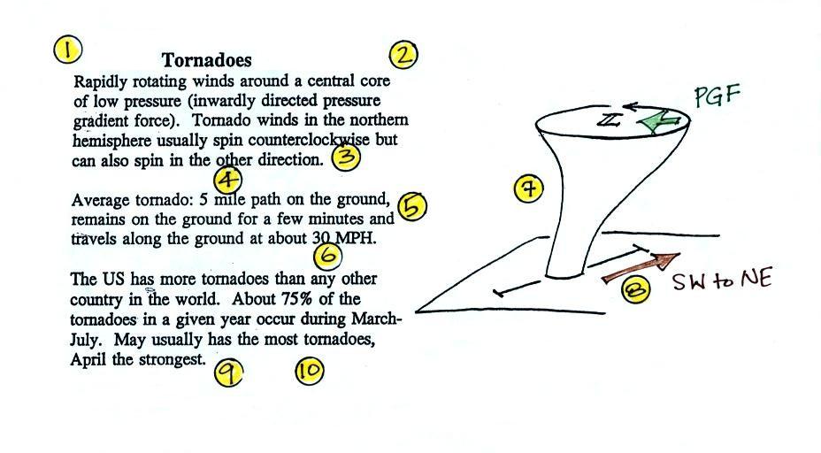
Here are some basic tornado
characteristics (the figure above is also on p. 161)
1. About 2/3rds (maybe 3/4) of tornadoes are
F0 or F1 tornadoes (this is referring to the Fujita Scale,
which we'll learn more about on Tuesday) and have spinning
winds of about 100 MPH or less. Microburst winds can
also reach 100 MPH. Microbursts are much more common in
Tucson in the summer than tornadoes and can inflict the same
level of damage.
2. A very strong inwardly directed pressure
gradient force is needed to keep winds spinning in a circular
path. The pressure in the center core of a tornado can
be 100 mb less than the pressure in the air outside the
tornado. This is a very large pressure difference in
such a short distance. The
PGF
is
much
stronger
than
the
Coriolis
Force
(CF)
and
the
CF
can
be
neglected.
The same pressure drop can be found in strong hurricanes but
it takes place over a much larger distance. The PGF
isn't as strong and the CF does play a role.
3. Because the Coriolis force doesn't play a
role, tornadoes can spin clockwise or counterclockwise, though
counterclockwise rotation is more common. This might be
because larger scale motions in the cloud (where the CF is
important, might determine the direction of spin in a
tornado).
4, 5, 6. Tornadoes usually last only a few
minutes, leave a path on the ground that is a few
miles long, and move at a few 10s of MPH.
There are exceptions, we'll look at one shortly.
7, 8. Most tornadoes move from the SW toward
the NE. This is because tornado-producing thunderstorms
are often found just ahead of a cold front where winds often
blow from the SW. Most
tornadoes
have
diameters
of
10s
to
a
few
100s of yards but tornadoes with diameters over a mile have
been observed. Tornado diameter can also be much larger
near the base of the thunderstorm than it is near the ground.
9, 10. Tornadoes
are
most
frequent
in
the
Spring.
The
strongest
tornadoes
also
occur
at
that
time
of
year.
You
don't need to remember the specific months. Tornadoes
are most common in the late afternoon when the atmosphere is
most unstable.
The information below was discussed
in class on Tuesday.
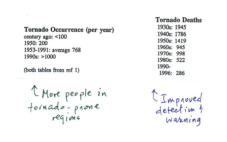
At the present time about 75 people are killed every year
in the United States by tornadoes. This is about a factor of
ten less than a century ago due to improved methods of detecting
tornadoes and severe thunderstorms. Modern day
communications also make easier to warm people of dangerous
weather situations. Lightning and flash floods (floods are
the most serious severe weather hazard) kill slightly more people
than tornadoes. Hurricanes kill fewer people on average than
tornadoes.
The increase in the number of tornadoes observed per year is
probably more due to there being more people in locations that are
able to observe and report a tornado rather than a true increase
in tornado activity.