Friday Nov. 9, 2012
Three songs ready to go on my IPOD and plenty of time before
class to play them all. You heard "Marching Bands of
Manhattan" (the organ at the start sounds very nice on the audio
system in ILC150) and "I Will Follow You
Into the Dark" from Death Cab for Cutie and "Reckoner" from
Radiohead.
The Experiment #3 reports have been graded and can be picked
up. Revised reports are due on or before Mon., Nov. 26 (it would
sure help a lot if you could get them in before Thanksgiving).
Click here to see if you have a
report ready to be picked up.
A new 1S1P topic on atmospheric
stability is now available.
The Quiz #4 Study Guide pt. 1 is now
online.
You can keep sending in toilet
observations up until 5 pm this
afternoon.
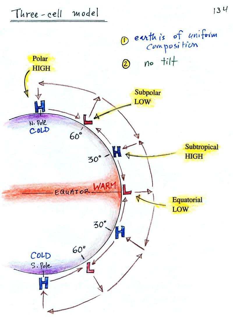
We finished up class on Wednesday with a crossection view of the
3-cell model predictions of global scale pressure and wind patterns on
the earth. The model assumes that the earth is of
uniform composition and that the earth's axis of rotation doesn't tilt.
Today we are going to look at the
3-cell model surface
features (pressure
belts
and
winds) in a little more detail. We're doing this because, even
with the unrealistic
assumptions of the 3-cell model, much of what is predicted is
actually found on the earth.
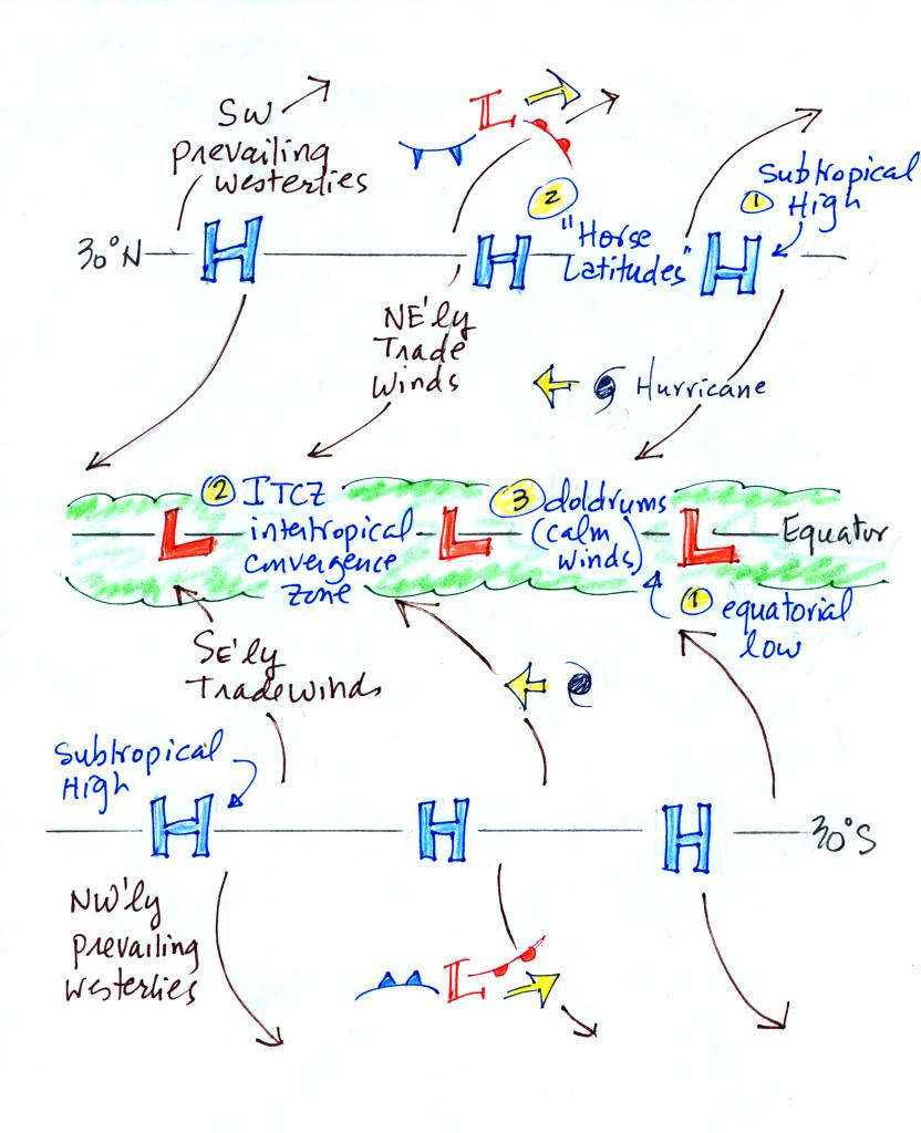
Here's the region between 45 S and 45 N latitude viewed from
above.
There's a lot of information on
this picture, but with a
little study you should be able to start with a
blank
sheet of paper and reproduce this figure. I would suggest
starting at the equator. You need to remember that there is a
belt of
low pressure found there, the equatorial low (pressure belt).
Then remember that the pressure belts
alternate: low pressure at the equator then belts of high
pressure at 30 N and 30 S.
Let's start at 30 S.
Winds will begin to
blow northward from High pressure at 30 S toward Low pressure at the
equator (also southward toward low pressure at 60 S latitude).
Once the winds start to blow they will turn to the left
because of the Coriolis force. Up at 30 N winds will also blow
southward toward the equator. They are bent to the right (you
need to
turn the page upside down and look in the direction the winds are
blowing). These winds just north and south of the equator are the
Trade
Winds (northeasterly trade winds north of the equator and
southeasterly trades south of the equator). They converge at the
equator and the air there rises (refer back to the crossectional view
of the 3-cell model). This produces a band of clouds that you
can often see at or near the equator on a satellite
photograph.
The Intertropical Convergence Zone or ITCZ is another name for the
equatorial low pressure belt. This region is
also referred to as the doldrums because it is a region where surface
winds are often weak. Sailing ships would sometimes get stranded
there hundreds of miles from land. Fortunately
it is a cloudy and
rainy region so the sailors wouldn't run out of drinking water (they
might well have run out of rum though).
Hurricanes form over warm ocean water in the subtropics between
the
equator and 30
latitude. Because winds at these latitudes have a strong easterly
component, hurricanes, at least early in their development, move
from east to west. Middle latitude storms found between 30 and 60
latitude, where the prevailing westerly
wind belt is found, move from
west to east.
You find sinking air, clear skies, and weak surface winds
associated
with the subtropical high pressure belt at 30 N and 30 S. This is
also known as
the horse latitudes. Sailing ships could become stranded there
also. Horses were apparently either thrown overboard (to conserve
drinking water) or eaten if food supplies were running low (Wikipedia
has a different explanation of the origin of the term "horse
latitudes"). Some of the hottest and driest locations on earth
are found near 30 latitude (Tucson is
located at 32 N latitude, so we are strongly affected by the
subtropical high
pressure belt).
The winds to the north of 30 N and to the south of 30 S are called
the
"prevailing westerlies."
They blow from the SW in the northern hemisphere and from the NW in the
southern hemisphere. The 30 S to 60 S latitude belt in the southern
hemisphere is mostly ocean. Because there is less friction over
the oceans, the prevailing westerlies there can
get strong, especially in the winter. They are sometimes referred
to as the "roaring 40s" or the "ferocious 50s" (the 40s and 50s refer
to the latitude belt they are found in).
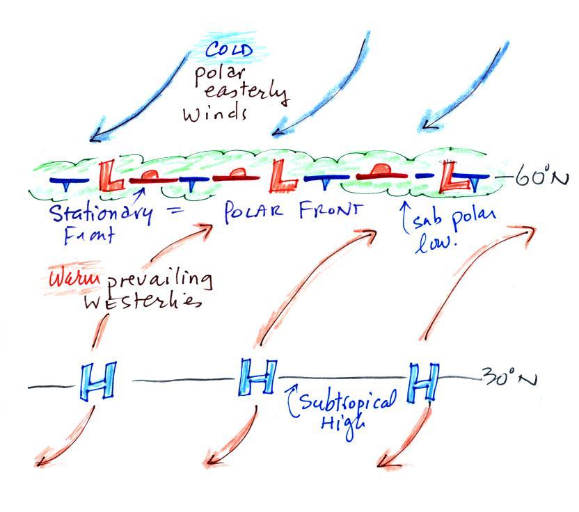
Here's a sketch of surface features
found from about 15 N to 75 N laitude. We didn't cover this
in class but I'll insert it here just for the sake of
completeness.
Winds
blowing north from H
pressure at 30 N toward Low pressure at 60 N turn to the right and blow
from the SW. These are the "prevailing westerlies."
The polar easterlies are cold winds coming down from high pressure at
the north pole. The subpolar low pressure belt is found at 60
latitude. This
is also a convergence zone where the cold polar easterly winds and the
warmer prevailing westerly winds meet. Because the air masses
south and north of 60 latitude are so different, the boundary between
these
two different kinds of air is called the polar front and is often drawn
as a stationary front on weather maps. A strong current of winds
called the polar jet stream is found overhead. Strong middle
latitude storms will often form along the polar front.
Here's a map that shows all of the
3-cell model surface features
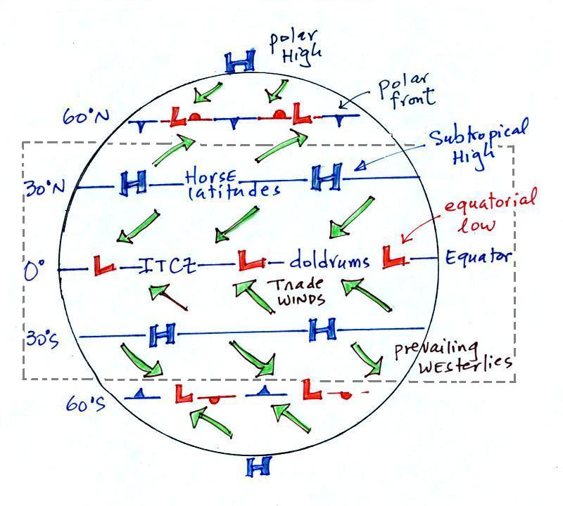
This is the same figure included on
the Quiz #4 Study Guide. With a little practice you should be
able
to start
with a blank
sheet of paper and reproduce this figure. Concentrate on
the features found between 45 S and 45 N latitude (everything inside
the dotted lines)
|
|
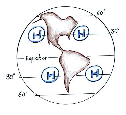
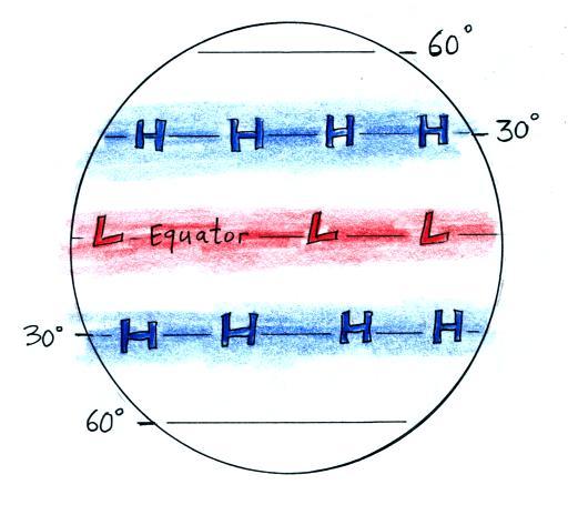
The 3-cell model
assumes that the earth is of uniform composition and not tilted toward
or away from the sun. It predicts belts of high pressure at 30 N
and 30 S latitude as shown above at left.
Because the
real world
has oceans and continents we find centers of high pressure, not
belts, located
near 30 latitude. They move north and south of 30 degrees during
the year as the N. Pole tilts toward and away from the sun.
This is shown a little more clearly on the figure below (on a
handout distributed in class)
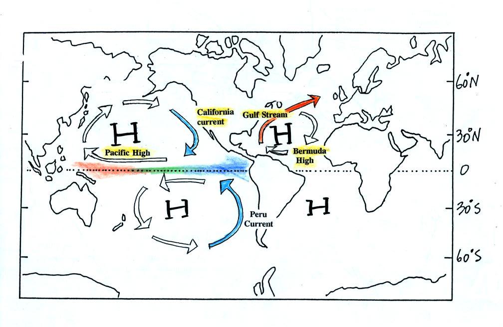
The high pressure center off the East Coast of the US is called
the Bermuda High. The Pacific High is found off the west
coast. Don't worry about the names of the Highs off the east and
west coasts of South America.
Winds blowing around these centers of high
pressure create some of the world's major ocean currents.
The California current is a cold southward
flowing current found off the west coast of the US. The Gulf
Stream is the warm northward flowing current along the east
coast.
We briefly mentioned the El Nino phenomenon in class on
Wednesday. Ocean water in the tropical Eastern Pacific is
normally cold. The water warms as it moves westward. This
temperature pattern is shown above. You can now better understand
why this is true. Two cold ocean currents, the California current
north of the equator and its analog in the southern hemisphere meet at
the equator in the eastern Pacific. That is why the water there
is so cold. During an El Nino event the two cold ocean currents
stop short of the equator. The ocean water temperature pattern
basically reverses. This has a profound effect on weather around
the globe.
The following two pictures show how the 3-cell models features
move during the season.
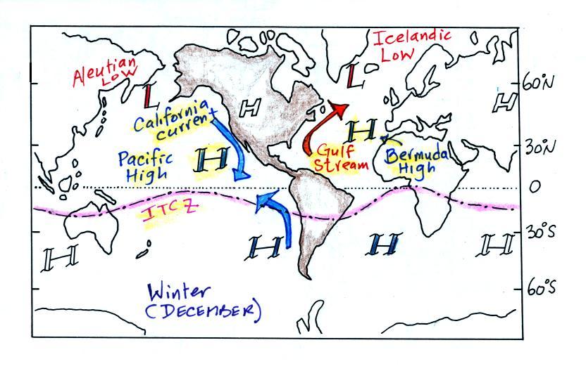
This is a winter picture (northern
hemisphere winter, the North Pole is tilted away from the sun).
All of the 3-cell model features have moved south of their nominal
locations. The intertropical convergence zone (ITCZ) which is
normally at the equator has moved south of the equator.
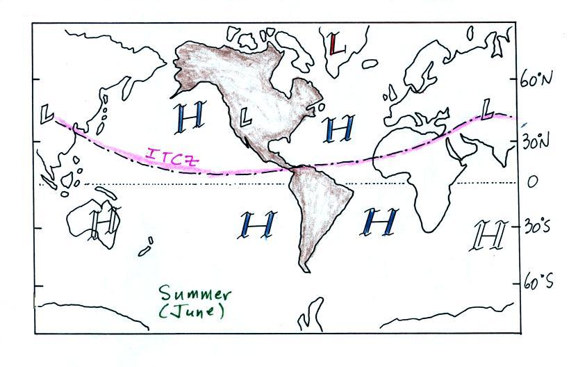
Here's the summer picture (North Pole tilted toward the sun). The
ITCZ has moved north of the equator.
The movement of the Pacific High north and south of its
nominal position near 30 degrees latitude is part of what causes our
summer monsoon in Arizona.
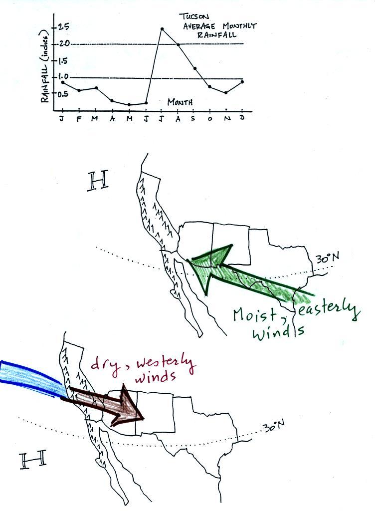
In the
winter the Pacific High is found south of 30 N latitude (the bottom of
the figure above).
Winds to the north of the high blow from the west. Air
originating over the Pacific Ocean is moist (though the coastal water
is cold so this air isn't as moist as it would be if it came off warmer
water). Before reaching Arizona the air must travel over high
mountains in California. The air loses much of
its moisture as it
does this (remember the rain shadow
effect). The air is pretty dry by the time it reaches
Arizona. Significant winter rains occur in Arizona when storms
systems are able to draw moist subtropical air from the southwest
Pacific ocean into
Arizona.
During the summer, the Pacific
High moves north of 30 N
latitude. Winds on the southern side of the subtropical high
have an easterly component. Moist air originating in Mexico
and from over warm water in the Gulf of Mexico blows into
Arizona. The sun heats the
ground during the day, warm moist air in contact with the ground rises
and
produces convective thunderstorms.
Tucson gets
about 12 inches of rain
in a normal year. About half of this comes during
the "summer monsoon" season. Remember the word monsoon refers to
a
seasonal change in wind direction.
