Friday, Nov. 2, 2012
Three songs from Iron and Wine this afternoon: "Freedom Hangs Like
Heaven", "The
Night Descending" and "The Devil Never
Sleeps".
Quiz #3 has been graded and was returned today. As always be
sure to carefully check for grading errors.
The revised Experiment #1 reports have finally been graded.
Thanks for being patient. You can click here to see if you have a graded
report waiting to be picked up.
There was a short In-class
Optional Assignment today. If
you'd like to download it and turn it in at the start of class next
Monday you can earn credit for the assignment.
We'll be covering a lot of topics in the next 3 weeks or so before
the last quiz of the semester: forces that cause the wind to blow the
way it does in the northern and southern hemispheres; thunderstorms,
tornadoes, and lightning; and hurricanes.
Today and Monday we will be looking
at how
and why
surface and upper level
winds blow the way they do.
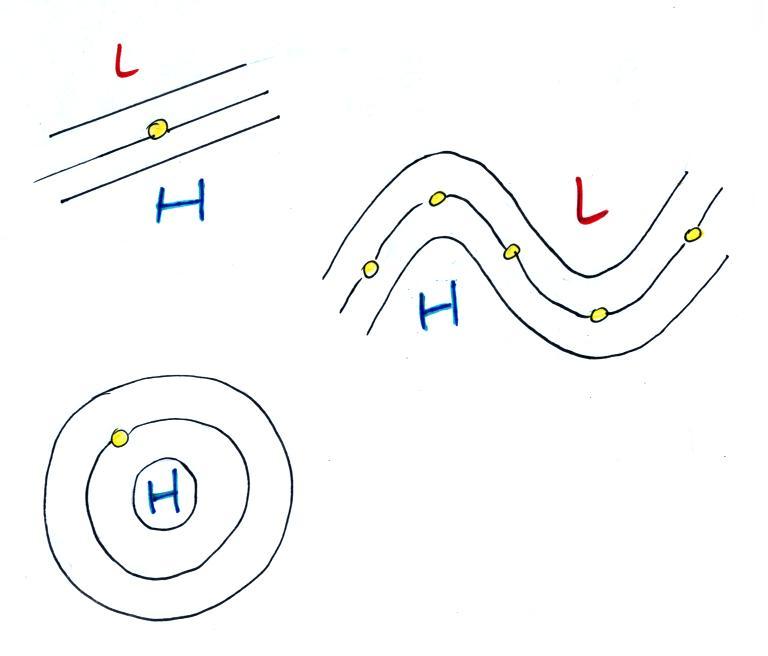
Some real world examples of where
this occurs are shown in the figure
below (found on p. 121 in the ClassNotes). The two largest types
of storm systems, middle latitude
storms (extratropical cyclones) and hurricanes (tropical cyclones),
develop around surface centers of low
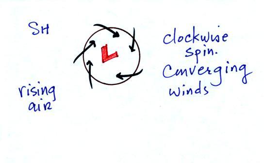
pressure. Winds
spin counterclockwise around cyclones (centers of low pressure) in the
northern hemisphere and
clockwise in the southern hemisphere.
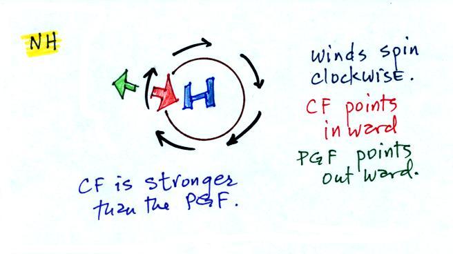
Winds spin clockwise around
"anticyclones" (high pressure) in the northern hemisphere and
counterclockwise in the southern hemisphere.
Why do winds blow in opposite directions around high and low
pressure. Why do the winds change directions when you move from
the northern to the southern hemisphere. These are the kinds of
questions we'll be addressing.
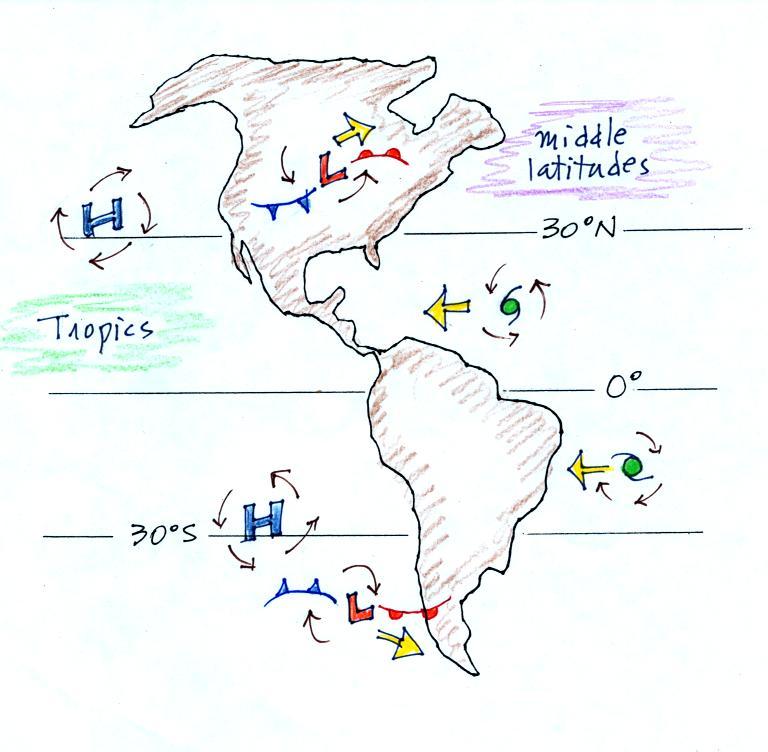
Storm systems in the tropics (0 to
30 degrees latitude) generally move
from east to west in both hemispheres. At
middle latitudes (30 to 60 degrees), storms move in the other
direction,
from west to
east. To understand why this is true we need to learn something
about the earth's global scale pressure and wind patterns. This
is a topic we will be getting into the middle of next week.
I've borrowed some more carefully
drawn figures below from a previous semester. Step #1 is found on
p. 122a in the
ClassNotes.
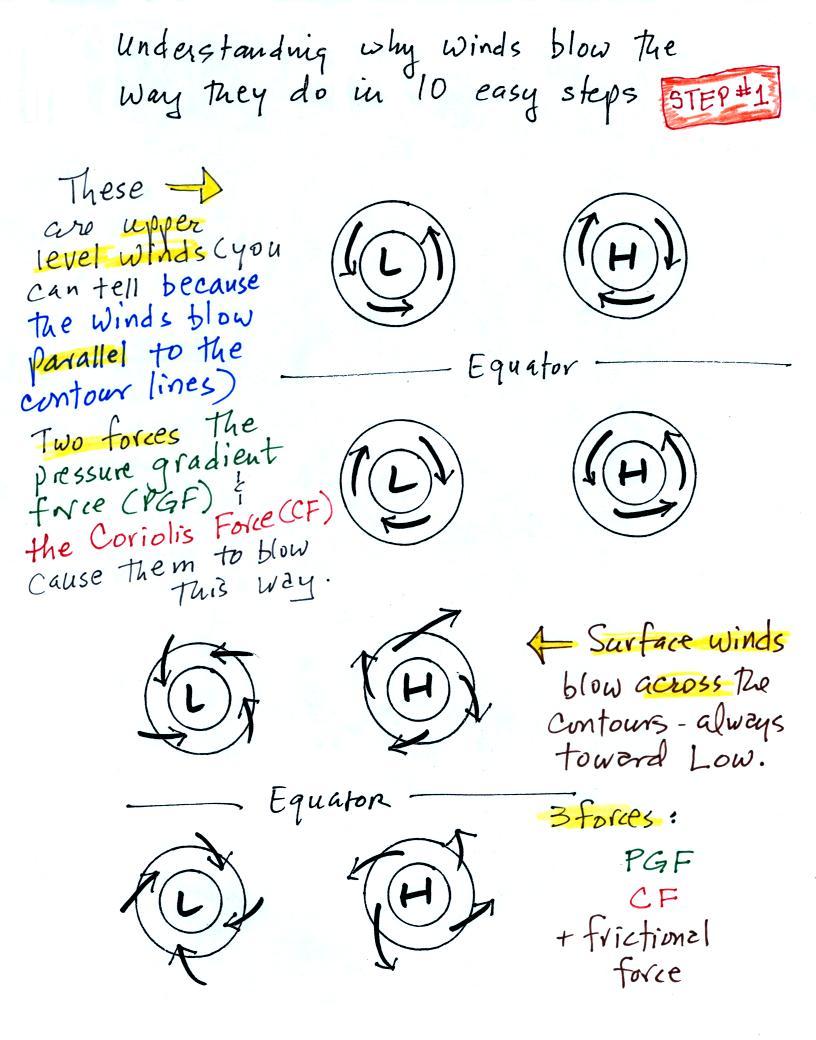
Upper level winds spinning around
high and low pressure in the
northern and southern hemispheres are shown in the first set of four
pictures. The first thing to notice is that upper level winds
blow parallel to the contours. Just 2 forces,
the
pressure gradient force (PGF) and the Coriolis force (CF), cause the
winds to blow this way. Eventually you will be able to
draw the directions of the forces for each of the four upper level
winds examples. Here is an
example
of what you will be able to do.
The four drawings at the bottom of the page show surface winds
blowing
around high and low pressure in the southern hemisphere. These
winds blow across the contour lines slightly, always toward low
pressure. The frictional force is what causes this to
occur. He is
an example of what you will be able to say about surface winds
blowing around low pressure in the southern hemisphere.
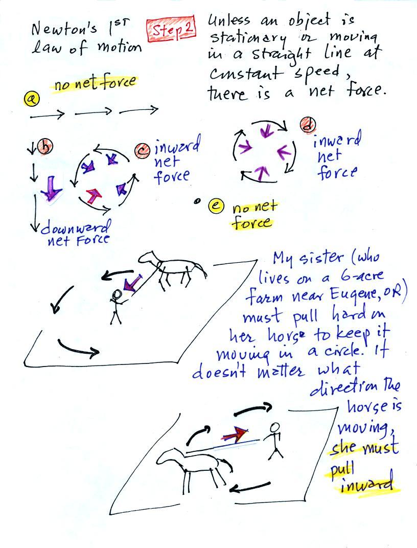
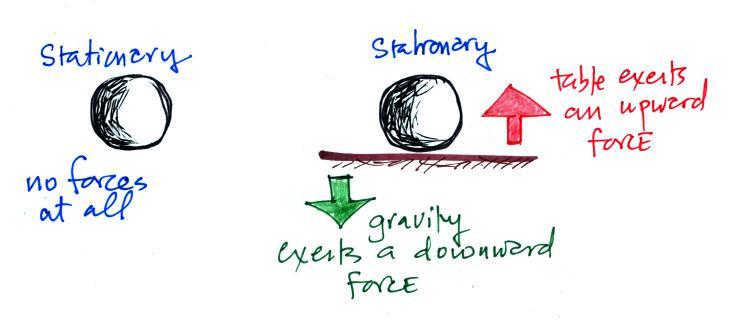
The two objects above are stationary. In both
cases there is no net force. At left there aren't any forces at
all. At right, forces are present but that cancel each other out
and the total or net force is zero. With zero net force both
objects will remain stationary.
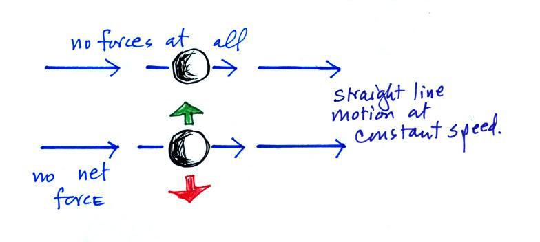
Here an object is moving in a straight line at constant speed.
For this to be true the net force must be zero in both cases (otherwise
the object would speed up, slow down, or change direction). As
long as the net force remains zero both objects will continue to move
in a straight line at constant speed.
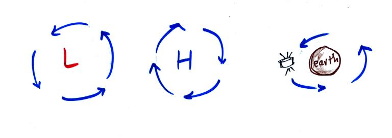
Another important point to take from Step #2
is that a net inward force is
needed anytime an object is moving in a circular path even if the speed
is constant. It doesn't
matter what direction the object is moving and it doesn't matter what
the object is circling around.
A net inward force is needed to keep winds spinning around a
center of low pressure, an inward force is needed to keep air moving in
a circular path around high pressure, and a net inward force (gravity)
is needed to keep a satellite in a circular orbit around the
earth. It wouldn't matter what direction the satellite is moving.
Now we'll
start to look at the forces that cause the wind to blow.
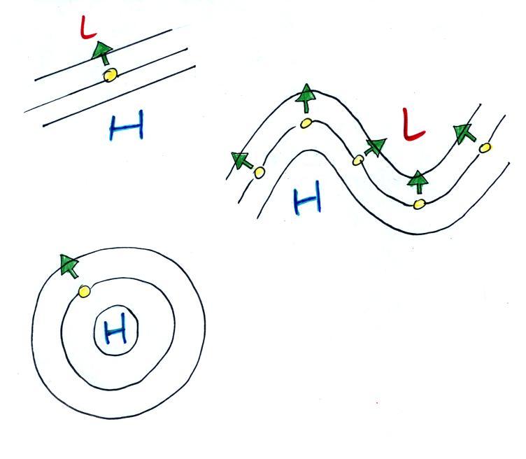
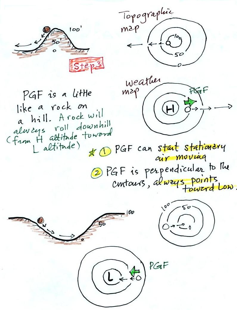
Pressure Gradient Force (PGF)
Air moving inward toward low
pressure or outward away from high pressure is similar to a rock
rolling down and away from the summit of a hill or inward toward the
bottom of a depression. The pressure gradient force always
points perpendicular to the contour lines on a map and toward low
pressure.
The PGF will cause stationary air to begin to move (it will always move
toward low
pressure).
Use the following figure (not shown in class)
to
test
yourself. With an arrow draw the direction of the PGF at
each of the points in the figure. You'll find the answers at the
end of today's notes.
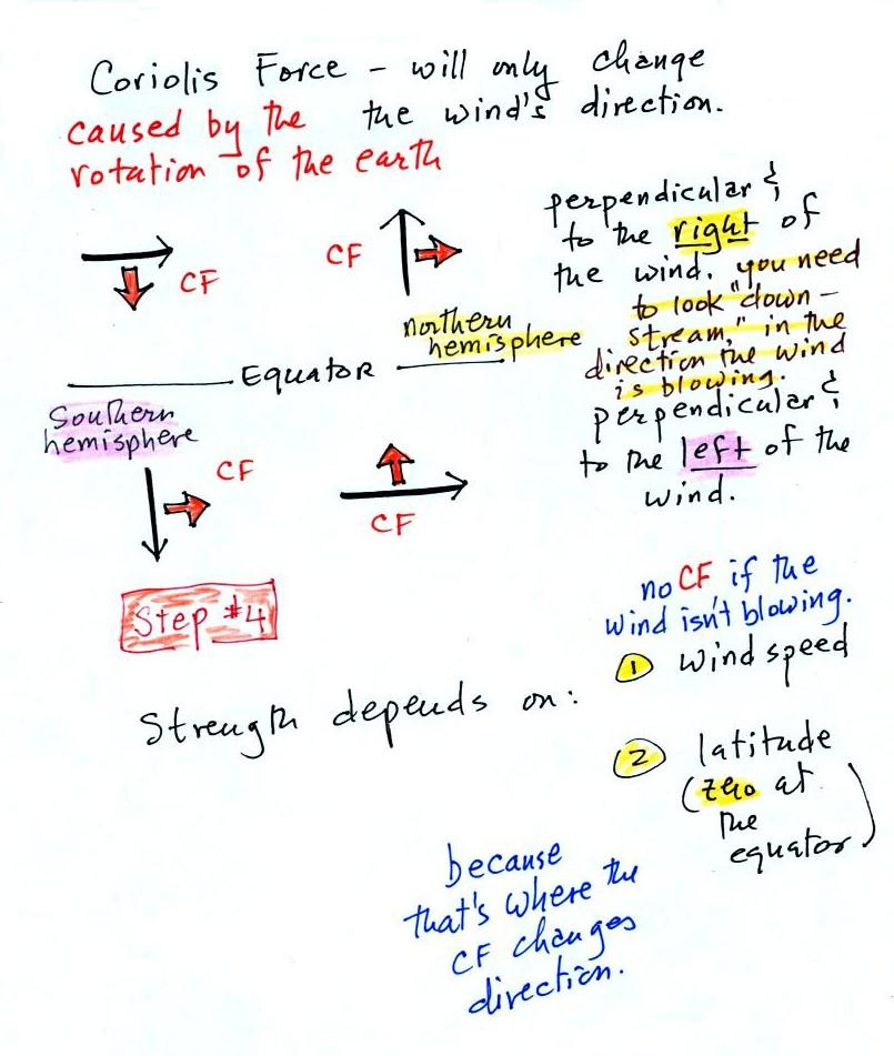
Coriolis
Force
The Coriolis force is caused by the
rotation of the earth. We'll learn more about what causes the
Coriolis force next Monday. The CF points
perpendicular to the wind and can only
change the wind's direction. It can't cause the wind to speed up
or
slow down. The direction of the CF depends on whether you're in
the northern or southern hemisphere.
Hurricanes don't form at the equator because there is no Coriolis
force there.
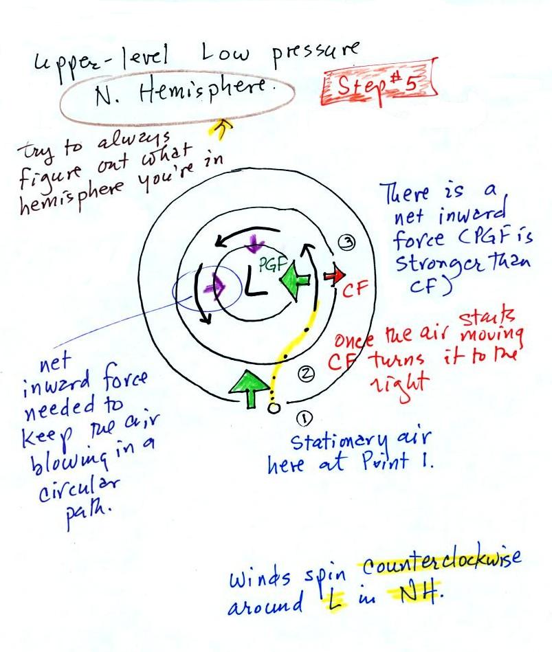
Time now to begin applying what
we've learned.
We start with some stationary air at Point 1. Because the air is
stationary, there is no Coriolis force. There is a PGF
force. The PGF at Point 1
starts stationary air moving toward the center of low pressure (just
like a rock would start to roll downhill).
Once the air starts to move, the CF causes it to turn to the right
(because this is a northern hemisphere chart). This is happening
at Point 2 (the dots show the initial motion of the air). As the
wind speeds
up the CF strengthens. The wind
eventually ends up at Point 3 blowing parallel to the contour lines and
spinning
in a
counterclockwise direction. Note that the inward PGF is stronger
than the outward CF. This results in a net inward force,
something that is needed anytime wind blows in a circular path.
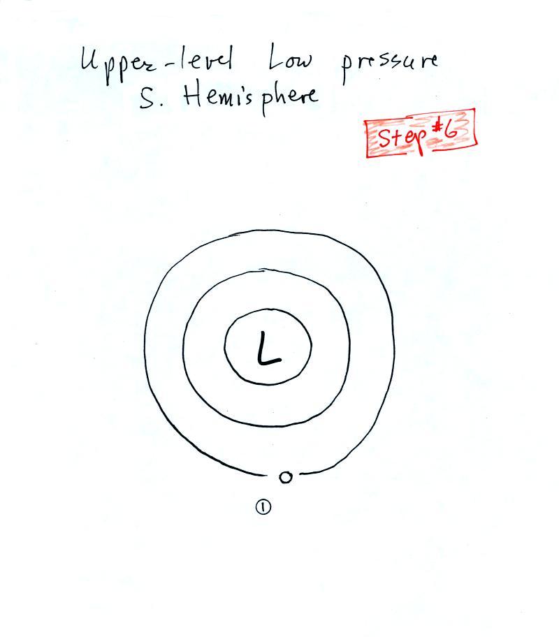
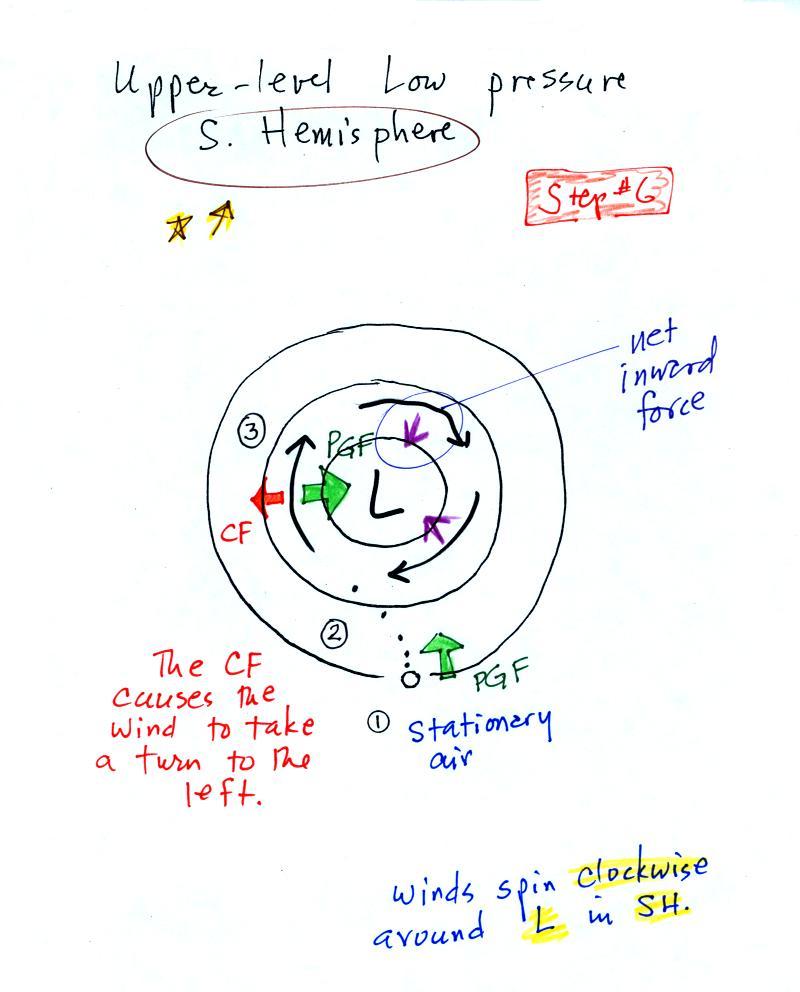
See if you can figure out
what would happen with low pressure in the Southern Hemisphere. We didn't have time
to do this in class.
We start again with some stationary
air at Point 1 in this
figure. You'll find the answer at the end of today's notes.
Below is the answer to the question embedded in the notes about
the PGF.
The mistake most people make is to
forget to draw the PGF perpendicular to the contours. It must be
perpendicular and point toward low pressure.
And here's how winds blow around Low pressure in the Southern
Hemisphere.