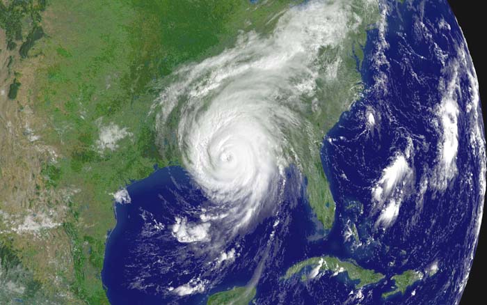
Hurricane Katrina making landfall
on Aug. 29, 2005. (source)
On average, hurricanes kill 20 people per year in the United
States
and cause about $5 billion of damage. As the table below
indicates though there are exceptional years (such as 2005) where the
death
and damage totals greately exceed these average values (data are
from www.economics.noaa.gov)
Year
|
Deaths
|
Total
Damage
(billion $ ))
|
2000
|
0
|
< 1
|
2001
|
24
|
6.5 B
|
2002
|
51
|
1.7 B
|
2003
|
14
|
2.3 B
|
2004
|
34
|
22.9 B
|
2005
|
1016
|
107.5 B
|
2006
|
0
|
< 1
|
2007
|
1
|
< 1
|
2008
|
11
|
7.9 B
|
2009
|
2
|
< 1
|
2010
|
0
|
< 1
|
2005 was, of course, the year
hurricane Katrina hit New Orleans. Three of the ten strongest
hurricanes ever observed in the N. Atlantic occurred in 2005 (Wilma was
the strongest and the new record holder, Rita was 4th and Katrina 6th
strongest). The
deadliest hurricane in US history is the
1900 Galveston hurricane which caused 6000 - 12,000 deaths. The
Great Hurricane of 1780 killed over 20,000 people in the Lesser
Antilles. Historic rainfall amounts (75 inches perhaps in some
locations) and flooding associated with Hurricane Mitch killed over
19,000 people in Honduras, Guatemala, and Nicaragua in 1998.
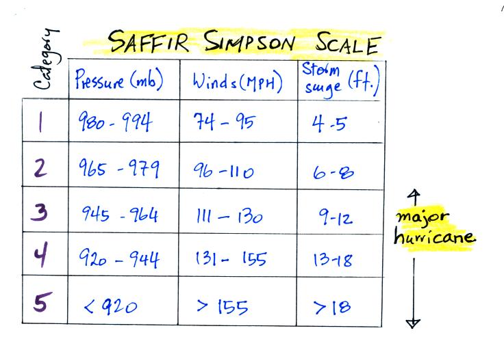
The Saffir Simpson Scale is used to rate hurricane
intensity
(just as the Fujita Scale is used for tornadoes). The scale runs
from 1 to 5. Remember that a hurricane must have winds of 74 MPH
or above to be considered a hurricane. Category 3,4, and 5
hurricanes are considered "major hurricanes" (in other parts of the
world the term super typhoon is used for category 4 or 5 typhoons).
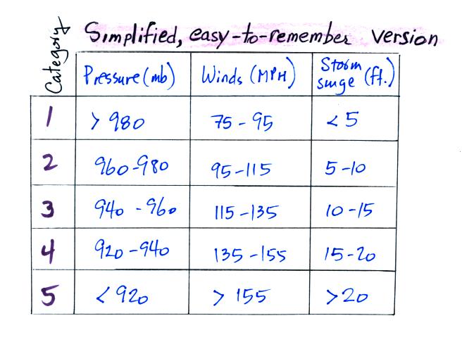
Here's an easy-to-remember version
of the scale
Pressure decreases by 20 mb,
wind speeds increase by 20 MPH, and the storm surge increases by 5 feet
with every change in level on the scale.
The storm surge listed above is a rise in ocean level when a hurricane
makes
landfall. This causes the most damage and the greatest number of
fatalities near a coast.
The converging surface winds associated with a hurricane sweep
surface water in toward the center of a hurricane
and cause it to pile up. The water sinks and, in deeper water,
returns to where it came
from. This gets harder and harder to do as the hurricane
approaches shore and the ocean gets shallower. So the
piled up water gets deeper and the return flow current gets stronger.
The National Weather Service has developed the SLOSH computer
model that tries to predict the height and extant of a hurricane storm
surge (SLOSH stands for Sea,
Lake, and Overland Surges from Hurricanes). You can
see some animations of SLOSH predictions run for hurricanes of
historical interest (including the Galveston 1900) hurricane at a
National Hurricane Center website (http://www.nhc.noaa.gov/surge)
If you watch closely you'll notice the highest surge is not where
the center of the hurricane makes landfall. We can use the figure
below to understand why this is true.
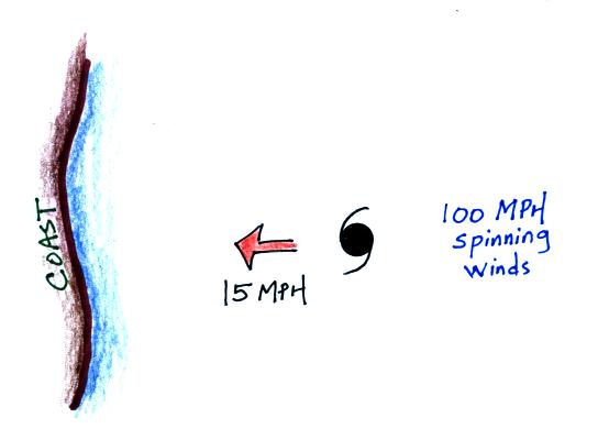
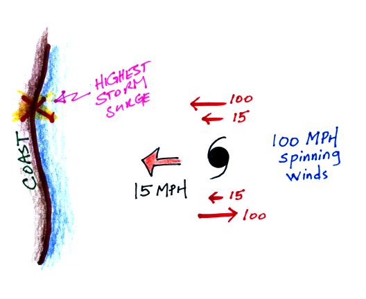
A hurricane is approaching a north-south oriented coast from the
east at 15 MPH. The winds are spinning in a counterclockwise
direction at 100 MPH around the center of the hurricane. Will the
fastest winds be on the north, south, east or west
side of the hurricane?
The fastest winds will be on the north side, because the
direction
of
motion
and
the
direction
of
the winds are both in the same direction. They
add, the winds are blowing straight toward the coast at 115
MPH.
On the south side the winds are pointing opposite the direction of
motion. Now you subtract the speed of motion from the wind
speed. The winds are 85 MPH and are blowing away from the coast
on the south side of the hurricane.
Once a hurricane moves onshore the winds weaken rapidly. The
greatest threat now becomes flooding from the tremendous amounts of
rain that a hurricane can produce. Tornadoes are also a danger.
One of the reasons the 1900 Galveston hurricane was so deadly was
that without radar and weather satellites it wasn't possible to provide
much advance warning of its approach. Meteorologists depended on
surface observations of pressure, winds, and ocean waves. Now, of
course, the National Hurricane Center can monitor development,
direction of motion, and strengthening as tropical storms move across
the Atlantic and can issue watches and warnings as needed.
|
Tropical Storm
|
Hurricane
|
Comments
|
Watch
|
Tropical storm conditions are
possible within the specified coastal area within 48 hours
|
Hurricane conditions are
possible within 48 hours. Issued 48 hours before the expected
start of tropical storm strength winds
|
People in the watch area should
obtain supplies, secure their homes and be prepared to evacuate
|
Warning
|
Tropical storm conditions are
expected within 36 hours or less.
|
Hurricane conditions are
expected within the specified coastal area. Issued 36 hours
before the expected onset of tropical storm strength winds.
|
|
Watch and warning leadtimes of 36 and 24 hours were used prior to
the 2010 hurricane season.
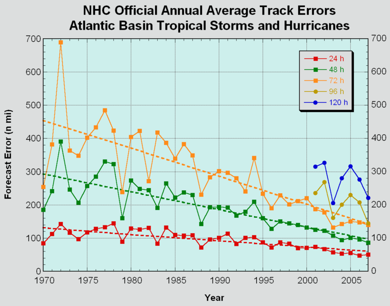
Predicting the future path of a hurricane is difficult because
hurricane movement is affected by nearby weather systems and the ocean.
The figure above shows that there has been considerable reduction
in the forecast errors. Predicting changes in the intensity of a
hurricane remains a problem however.
Some researchers also try to forecast how active the upcoming hurricane
season will be. Probably the best known forecas of this type is
issued by Dr. William Gray from Colorado State University. You
can look at the latest predictions here.
We have mentioned that 2005 was a record breaking year,
at least as far as N. Atlantic hurricanes were concerned. There
were
28
named
storms
(tropical storms or hurricanes) which easily beat
the old record of 21 named storms in a year. As a
matter of fact the pool of available names was exhausted and the last
few hurricanes were named using Greek characters.
The most intense N. Atlantic hurricane ever (Wilma) occurred in 2005;
hurricane Katrina
was the 3rd most intense Atlantic hurricane to hit the US
mainland. The 1935 Labor Day storm and
Camille are still #1 and #2, Andrew is #4. Katrina
became (easily) the most costly natural disaster in US history.
There is a tendency to blame an unusual year like this on global
warming. We have seen that there has been a small increase in
global average surface temperatures over the past 150 years. The
world's oceans also appear to have warmed. We know that
hurricanes form over warm ocean water so it is reasonable to expect
that warmer oceans might produce more frequent and more intense
hurricanes.
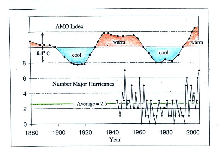
In the Atlantic there does seem to be a pretty good correlation between
the Atlantic Multidecadal Oscillation (AMO) Index, which is a measure
of sea surface temperature, and the frequency of
major hurricanes. Greater than average numbers of major
hurricanes
tend to occur during warm periods of the AMO Index and vice
versa. The correlation isn't quite as apparent when the total
number of hurricanes is plotted. We only have reliable hurricane
frequency data for a limited period of time, for the period of time
when satellites have been able to monitor hurricane development over
the oceans. This is probably not enough time to be able to say
whether global warming has had an effect or not.
Globally there are about 90 tropical cyclones per year and this number
doesn't seem to have changed over the past 40 to 50 years either.
At one point scientists thought that there might have been a recent
increase in the intensity of hurricanes
that could be tied to global warming. But more recently
scientists have come to question that conclusion also. One
recent article suggests that climate change might cause the number
of hurricanes that occur globally to decrease. Hurricanes that do
form however would most likely be more intense and produce more
rain. It seems clear that we will need several more decades of
hurricane data before we can determine whether global warming has an
effect on hurricane numbers or strength.