Now that
we've finished the section on cloud identification this is a good
time to learn a little bit about the 2
most common types of satellite photographs.
IR photographs
When you see satellite
photographs
of clouds on the TV weather you are probably seeing infrared
satellite photographs.
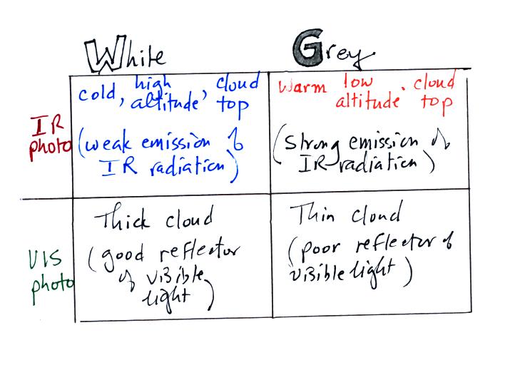
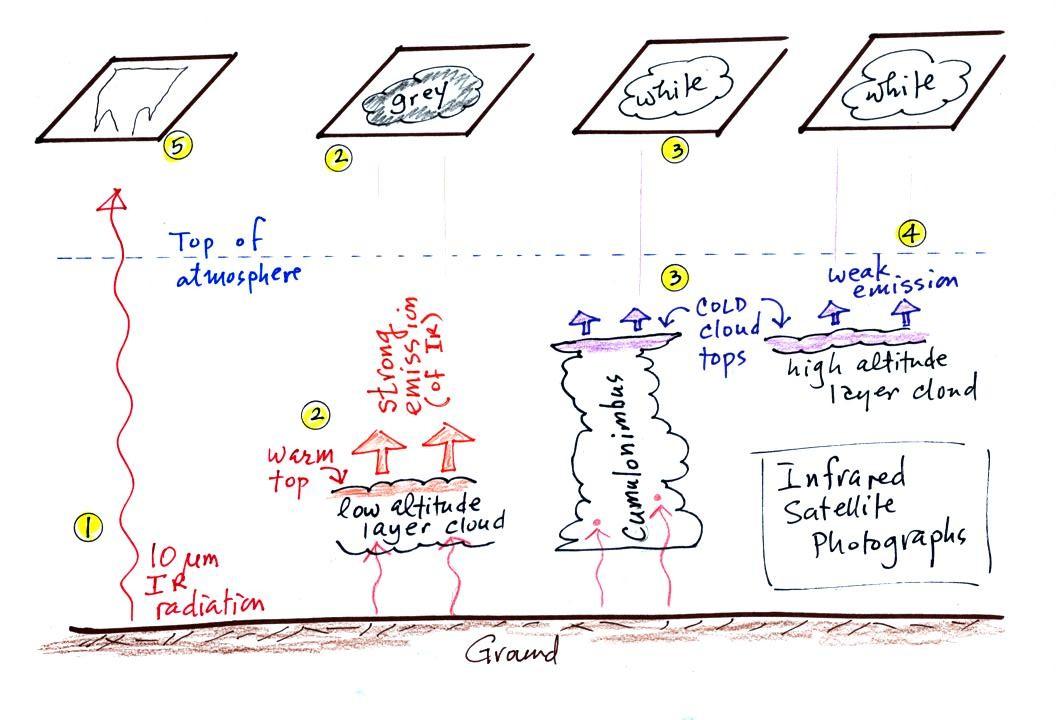
1. An infrared satellite photograph detects the 10 micrometer (um)
IR
radiation
actually
emitted by the ground, the ocean and by clouds. You don't
depend
on seeing
reflected
sunlight, so clouds
can be photographed during the day and at
night. You may recall that 10 um radiation is in the
middle of
the atmospheric window, so this type of radiation is able to pass
through air
without being absorbed. If clouds don't get in the way, you can
see the ground on an IR photograph.
2. Clouds absorb 10 um radiation and then emit
IR radiation. The top surface of a low altitude cloud will be
relatively warm. Warmer objects emit IR radiation at a greater
rate or at higher intensity (the Stefan Boltzmann law).
This is shown as grey on an IR satellite photograph. A
unimpressive
grey
looking
cloud
on
an
IR
satellite
photograph
may
actually be a thick nimbostratus cloud that is
producing a lot of rain or snow.
3. Cloud tops found at high altitude are cold and emit
IR
radiation at a lower rate or lower intensity. This shows up
white on an IR photograph.
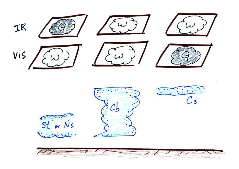
4. Two very different clouds (a thunderstorm and a
cirrostratus cloud) would both appear white on the satellite photograph
and would be difficult to distinquish. Meteorologists are
interested in locating tall thunderstorms because they can produce
severe
weather.
5. The ground changes temperature during the course of
the
day. On an infrared satellite animation you can watch the ground
change from dark grey or black (afternoon when
the ground is warmest) to lighter grey (early morning when the ground
is cold)
during the course of a day. Because of water's high specific
heat, the ocean right alongside doesn't
change temperature much during the day and remains grey throughout the
day. Here's a link
to an IR satellite photograph loop.
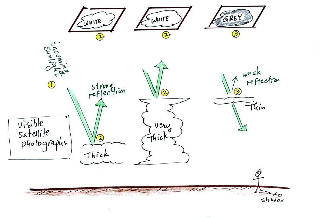
A visible satellite photograph
photographs sunlight that is
reflected
by clouds. You won't see clouds on a visible satellite photograph
at night. Thick clouds are good reflectors and appear
white. Thinner clouds don't reflect as much light and appear
grey. The low altitude layer cloud and the thunderstorm above
would
both appear white on this photograph and would be difficult to
distinquish.
Here's a summary of what we have
learned so far.
The figure below shows
how
if
you
combine
both
visible
and
IR
photographs
you
can
begin
to distinquish between different types of
clouds.
The next topic we will cover is
precipitation formation and types of
precipitation. Only two of the 10 main cloud types are able to
produce
significant amounts of
precipitation. Apparently it isn't as easy for clouds
to make precipitation as you might think.
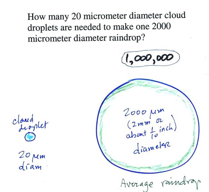
This figure shows typical sizes of
cloud
condensation nuclei (CCN), cloud droplets, and raindrops (a human hair
is about 50 um thick for comparison). It is relatively easy to
make cloud droplets (the cloud that forms around a piece of dry ice or
when you exhale on a cold day contains water droplets or ice
crystals). You cool moist air to the dew
point and
raise the RH to 100%. Water vapor
condenses pretty much instantaneously onto a cloud condensation nucleus
to form a cloud droplet. It
would take much longer for condensation to turn a cloud
droplet
into a
raindrop. You know from personal experience that once a cloud
forms you don't have to wait very long for precipitation to begin to
fall.
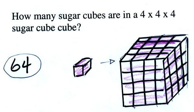
Part of the problem is that it
takes quite a few 20 um
diameter cloud
droplets to make one 2000 um diameter raindrop. How many
exactly? Before answering that question we will look at a cube
(rather than a sphere).
It would take 64 individual sugar
cubes to make a 4 cube x 4 cube x 4 cube cube. That is because
the bigger cube is 4 times wider, 4 times deeper, and 4 times
taller. Volume is 3 dimensions.
The raindrop is 100 times wider,
100 times
deeper, and 100 times taller than the cloud droplet. The raindrop
has a volume that is 100 x 100 x 100 = 1,000,000 (one million) times
larger than the volume of
the cloud droplets.
Fortunately
there
are
two
processes
capable
of quickly
turning small cloud droplets
(or ice crystals) into much larger precipitation particles in a cloud.
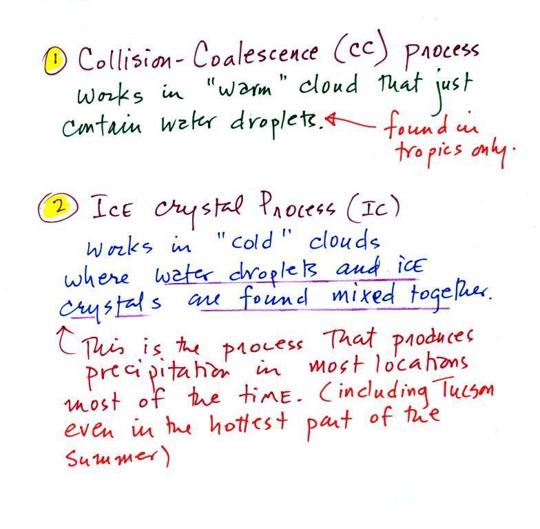
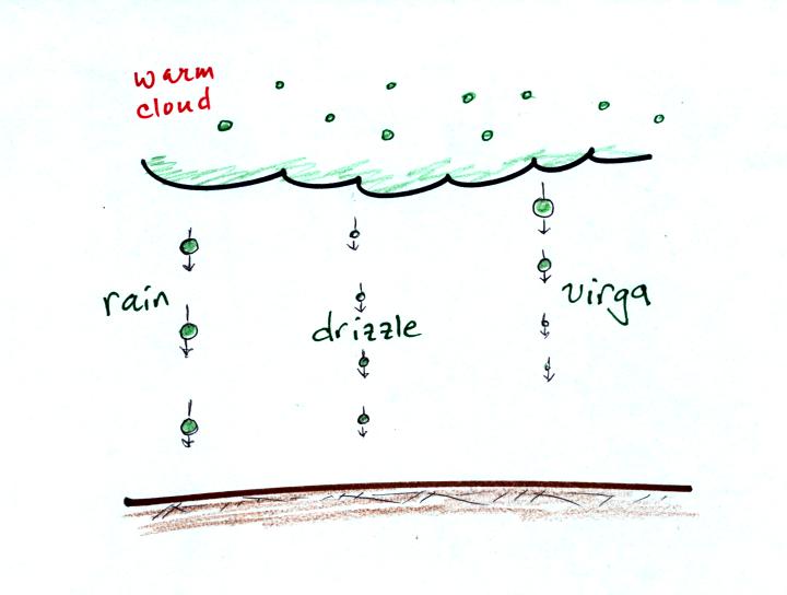
The collision coalescence process
works in clouds that
are
composed of water droplets only. Clouds like this are only found
in
the tropics. We'll see that this is a pretty easy process to
understand. This process will only produce rain, drizzle, and
something called virga (rain that evaporates before reaching the
ground).
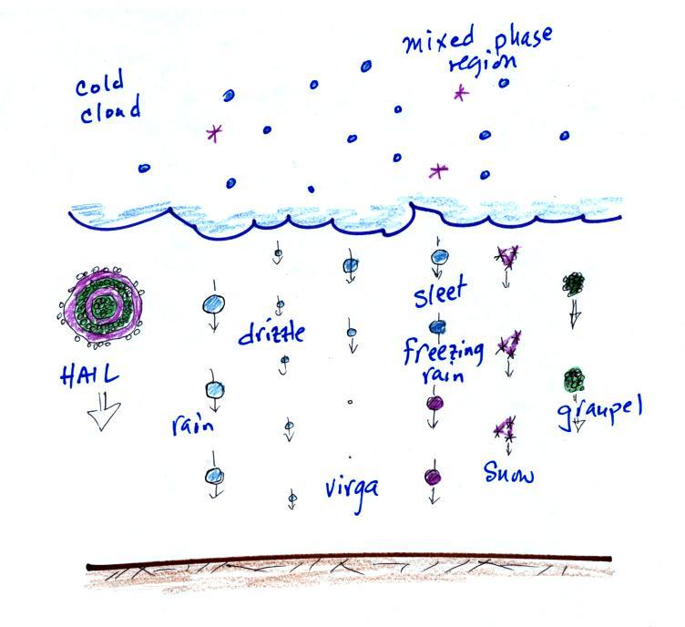
The ice crystal process produces precipitation everywhere
else.
This is the process that makes rain in
Tucson, even on the hottest day in the summer (summer thunderstorm
clouds are tall and reach into cold parts of the atmosphere where
temperatures drop well below
freezing). Hail and graupel (a precipitation particle that is
often mistaken for hail) frequently
fall from these storms; proof that the precipitation started out as an
ice particle. This
process can also produce other kinds of precipitation
such as snow and sleet.
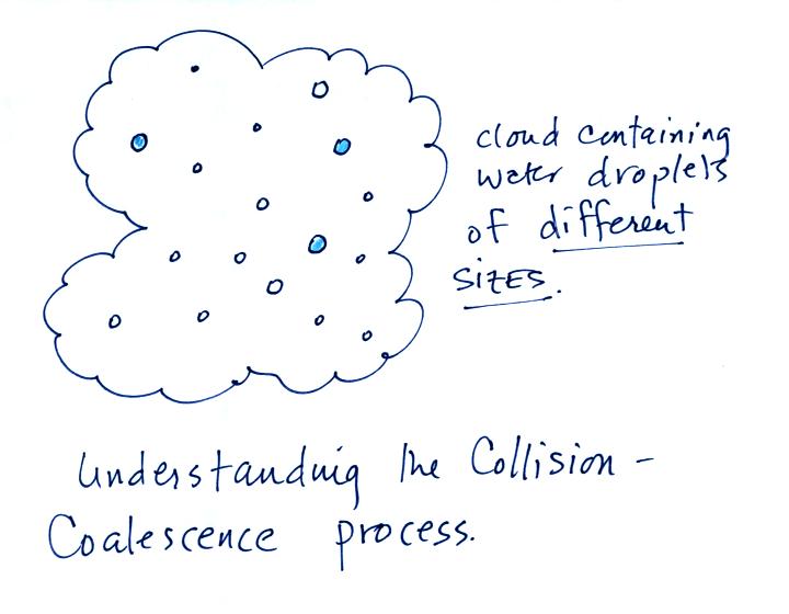
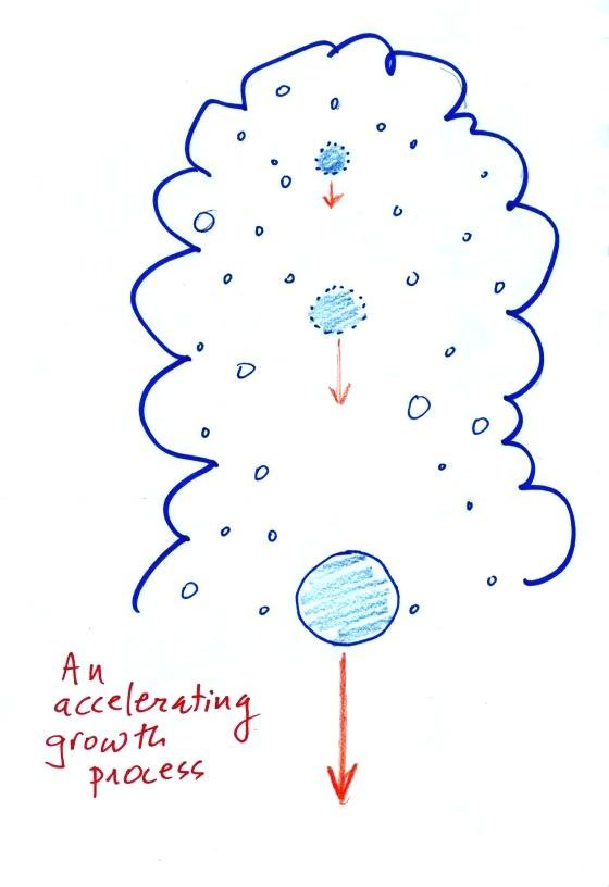
Here's
what you might see if you looked inside a warm cloud that contained
just water
droplets:
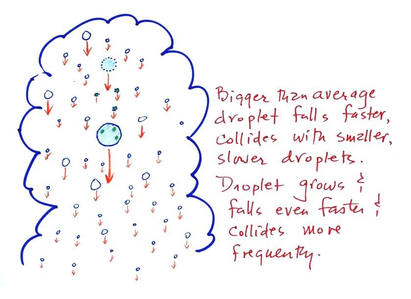
The collision coalescence process works best in a cloud
filled with cloud droplets of different sizes. A larger than
average cloud
droplet will fall faster, overtake, and collide with smaller slower
moving
ones. The colliding droplets then often merge to form a larger
droplet.
This is an acclerating growth process.
As the falling droplet grows it falls faster, and sweeps out an
increasingly larger volume
inside the cloud. The rate of growth accelerates as the droplet
gets bigger.
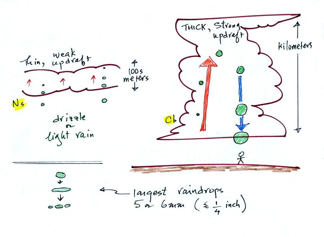
The figure
below shows the collision-coalescence process at work in the two
precipitation producing clouds:
nimbostratus (Ns) and cumulonimbus (Cb).
Ns clouds are thinner
and have weaker updrafts than Cb clouds. The largest raindrops
fall from Cb clouds because the droplets spend more time in the cloud
growing. In a Cb cloud raindrops can grow while being carried upward by
the updraft and also when falling in the downdraft.
Raindrops grow up to about 1/4 inch in diameter.
When
drops get
larger than that, wind resistance flattens out the drop as it falls
toward the ground. The drop begins to "flop" around and breaks
apart
into several smaller droplets. Solid precipitation particles such
as hail can get much larger (an inch or two or three in diameter).
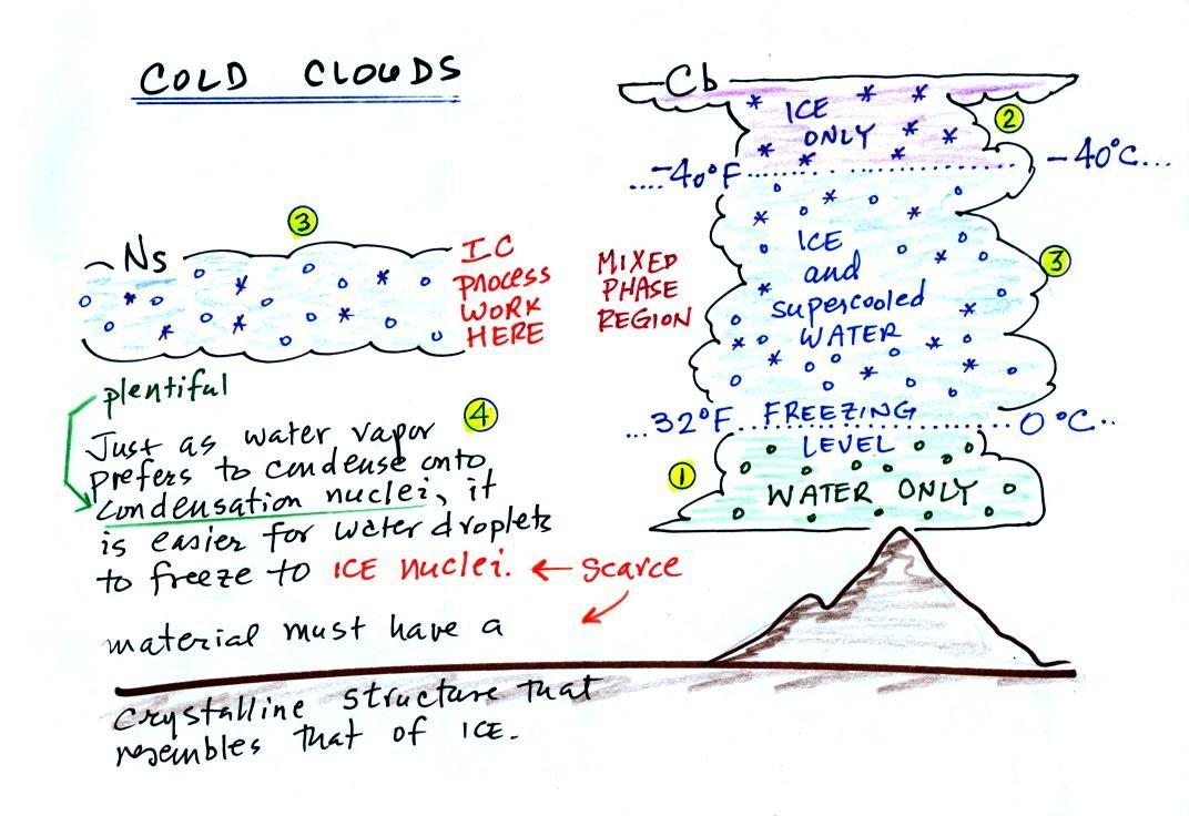
Most clouds or at least portions of most clouds will contain ice
crystals. In these cases the ice crystal process will be the
dominant precipitation producing process. Here are a couple of
carefully drawn pictures of the internal structures of cold clouds
The bottom of the thunderstorm,
Point 1, is warm
enough
(warmer than freezing) to just
contain water
droplets. The top of the thunderstorm, Point 2, is colder than
-40 F (equal to -40 C) and just contains ice crystals. The
interesting part of the
thunderstorm and the
nimbostratus cloud is the middle part, Point 3, that contains both
supercooled water
droplets (water that has
been cooled to below freezing but hasn't frozen) and ice
crystals.
This is called the mixed phase
region. This is where the ice crystal process will be able
to produce
precipitation. This is also where the electrical charge that
results in lightning is generated.
The supercooled water droplets aren't able to freeze even though
they
have been cooled below freezing. At Point 4 we see this is
because it is much
easier for small droplets of water to freeze onto an ice crystal
nucleus or for water vapor to be deposited onto an ice crystal nucleus
(just like it is easier for water vapor to condense onto
condensation nuclei rather than condensing and forming a small droplet
of pure water). Not just any material will work as an ice nucleus
however. The material must have
a crystalline structure that is like that of ice. There just
aren't very many materials with this property and as a result ice
crystal nuclei are rather scarce.