Tuesday Nov. 22, 2011
click here to
download today's notes in a more printer friendly format
A long chain of events lead to this morning's music
selection. First I've been reading lots of Foucault
Pendulum reports. Several students mentioned they would like to
go to Paris to see the replica of Foucault's original pendulum (an
excellent idea).
Over the weekend I went to watch one of our graduate students play at a
Southern Arizona Symphony Orchestra which featured a composition by
George Gershwin. That made me thing of "Rhapsody in Blue" so I
downloaded a couple of shorter versions of
it. The one you heard in class featured Pearl Kaufman on
piano. I couldn't find that online, but here's a pretty good
substitute. While looking online I found a pretty amazing
version of "Bumble
Boogie" that was played by Pearl Kaufman.
The Foucault Pendulum reports and the Stability Analysis
have been
graded and were returned in class today. Once a topic is graded,
we update the list
of
students that
have earned 45 1S1P pts.
I have found many of the tornadoes that I tried to show in class last
Thursday online. I replayed a couple of them this morning (the
McConnell
AFB tornado and the Kansas
Turnpike tornado. The turnpike video also has a
warning
that a highway underpass is actually a very dangerous place to take
shelter from a tornado. Here is some additional
information from the Norman OK office of the National Weather
Service. Slide 6 lists some of the reasons why underpasses are so
dangerous.
The figure
below (p. 162 in the ClassNotes) illustrates the life cycle of a
tornado. Have a close look at the next tornado you see on video
and see if you can determine whether it is in one of the early or late
stages of its development.
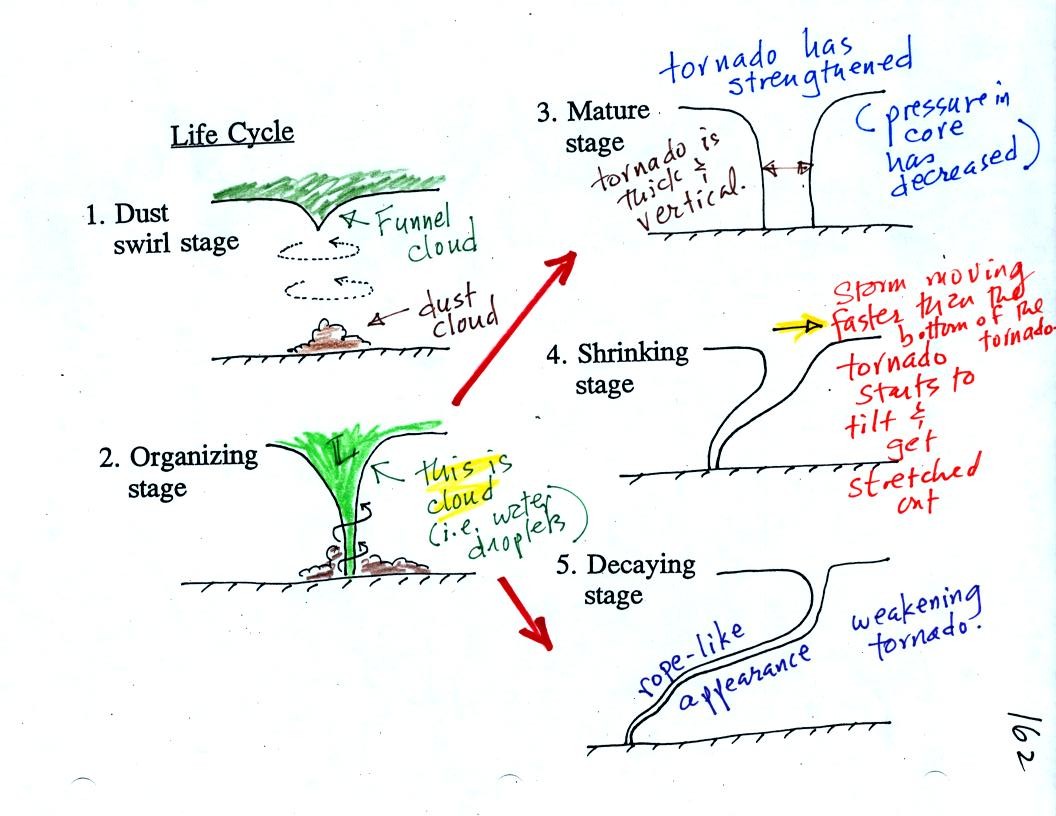
Tornadoes begin in and descend from
a
thunderstorm. You would usually see a funnel cloud dropping from
the base
of the thunderstorm. Spinning winds will probably be present
between the cloud and ground before the tornado cloud becomes
visible. The spinning winds can stir up dust at ground
level. The spinning winds might also be strong enough at this
point to produce some minor damage. Here is video of a tornado
in
Laverne
Oklahoma that shows the initial dust swirl stage very well.
In Stage 2, moist air moves horizontally toward the low pressure
in the
core of the tornado. This sideways moving air will expand and
cool just as rising air does (see figure below). Once the air
cools enough (to the
dew point temperature) a cloud will form.
Tornadoes can go from Stage 2 to Stage 3 (this is what the
strongest
tornadoes do) or
directly from stage 2 to stage 5. Note a strong tornado is
usually vertical and thick as shown in Stage 3. "Wedge tornadoes"
actually appear wider than they are tall.
The thunderstorm and the top of the tornado will move faster than
the
surface winds and the bottom of the tornado. This will tilt and
stretch the tornado. The rope like appearance in Stage 5 is
usually a sign of a weakening (though still a dangerous) tornado.

A tornado cloud forms is mostly the same way that
ordinary
clouds do. Moist air
moves into lower pressure surroundings and expands. The expansion
cools the air. When the air cools to its dew point a cloud
forms.
This
seemed like a good place to briefly discuss supercell thunderstorms.
Here is a
relatively simple
drawing showing some of the key features on a supercell
thunderstorm. In a supercell the
rotating
updraft (shown in red above) is strong enough to penetrate into the
stratosphere. This produces the overshooting top or dome feature
above. A wall cloud and a tornado are shown at the bottom of the mesocyclone. In an ordinary thunderstorm
the updraft
is unable to penetrate into the very stable air in the stratosphere and
the
upward moving air just flattens out and forms an anvil. The
flanking line
is a line of new cells trying to form alongside the supercell
thunderstorm.
Here
is a second slightly more complicated drawing of a supercell
thunderstorm. A typical air mass thunderstorm (purple) has been
drawn in
for comparison.
A short segment
of video was shown at this point (again without sound). It showed
a distant supercell
thunderstorm and photographs of the bases of nearby
supercell thunderstorms. Here you could see the spectacular wall
cloud that often forms at the base of these storms. Finally a
computer simluation showed some of the complex motions that form inside
supercell thunderstorms, particularly the tilted rotating
updraft. I haven't been able to find the video online.
A wall cloud can form a little bit
below the rest of the base of the thunderstorm. Clouds normally
form when air
rises, expands, and cools as shown above at left. The rising air
expands because it is moving into lower pressure surroundings at higher
altitude.
At right the air doesn't have to rise to as high an altitude to
experience the same amount of expansion and cooling. This is
because it is moving into the core of the rotating updraft where the
pressure is a little lower than normal for this altitude. Cloud
forms a little bit closer to the ground.
Photograph of the base of a thunderstorm
showing part of the
wall cloud
and what looks like a small and weak tornado. (from
the
University
Corporation
for Atmospheric Research)
Thunderstorms
with rotating updrafts often have a distinctive radar signature called
a hook echo.
We haven't
discussed weather radar
in this class yet. In some ways a radar image of a thunderstorm
is
like an
X-ray photograph of a human body. The Xrays
pass through the flesh but are partially absorbed by bone.
Xrays pass through tissue but get absorbed
by bone.
They reveal the skeletonal structure inside a body. In some
respects radar is similar.
The
radio signals
emitted by radar
pass through the cloud itself but are reflected by the much larger
precipitation particles. The intensity of the reflected signal
(the echo) is color coded. Red means an intense reflected signal
and lots of large precipitation particles. The edge of the cloud
isn't normally seen on the radar signal.
Here is an actual radar image
with a prominent
hook echo.
This is
the radar image of a thunderstorm that produced a very strong tornado
that hit Oklahoma
City in May
1999
. The hook echo is visible near the lower left hand
corner of the picture. Winds in the tornado may have
exceeded 300 MPH. You can read more about this tornado here.
And
here
is
some
storm
chase
video of the tornado.
It is very hard to
actually
measure the speed
of the
rotating winds in a tornado. Researchers usually survey the
damage caused by the tornado to come up with a Fujita Scale
rating.
Here
is the link to the photos that were shown in class with some discussion
from the National Oceanic and Atmospheric Administration
Storm Prediction Center.
The photographs
below weren't shown in class.
Roof damage is typical of an F1
tornado. The buildings on
the left suffered light roof
damage.
The barn
roof at right was more heavily damaged. Barns present a larger
crossection to the wind and often aren't built as sturdily as a house.
More severe damage to what
appears
to be a well built
house
roof but still an F1 tornado.
Even relatively weak winds can damage a mobile home. F1
tornado winds can easily tip over a mobile home if it is
not
tied down (the
caption states that an F1 tornado could blow a moving car off a
highway). F2 level winds (bottom photo above) can roll and
completely
destroy a
mobile home.
Trees, if not uprooted, can suffer serious
damage from
F1 or
F2 tornado
winds.
F1 winds will damage a roof, F2 level winds can completely remove
the
roof. The outside walls of the building are still standing.
The roof is gone and the outer walls of this house were
knocked
down in the photo above. This is characteristic of F3 level
damage. In a house
without a basement or storm cellar it would be best to seek shelter in
an interior closet or bathroom (plumbing might help somewhat to keep
the walls intact).
In some tornado prone areas, people construct a small closet or
room
inside their home made of reinforced concrete.
A better solution
might be to have a storm cellar located underground.
An F4 tornado knocked down all of the walls in the top photo but
the
debris is
left nearby. All
of the sheet metal in the car body has been removed in the bottom photo
and the car chasis has been bent around a tree. The tree has
been stripped of all but the largest branches.
An F5 tornado completely destroyed the home in the
photo
above and
removed most of the debris. Only bricks and a few pieces of
lumber are left.
I would have liked to have played another
video tape of a tornado that struck Pampa Texas but decided not to
because of the audio problems. I did manage to find the tornado
online even though it was missing some of the interesting commentary on
the tape so we watched that. Near the end of
the segment, the video showed several vehicles (pick up trucks
and a van) that had been lifted 100 feet or so off the ground and were
being thrown around at 80 or 90 MPH by the tornado
winds. Winds speeds of about 250 MPH were estimated from the
video photography (the wind speeds were measured above the ground and
might not have extended all the way to the ground).
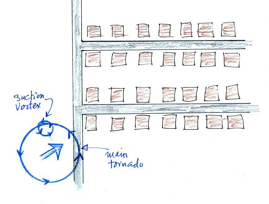
Several levels of damage (F1-F3)
are visible in the
photograph
above. It
was
puzzling initially how some homes could be nearly destroyed while a
home nearby or in between was left with only light damage. One
possible explanation is shown below (from the bottom of p. 164 in the
photocopied ClassNotes.
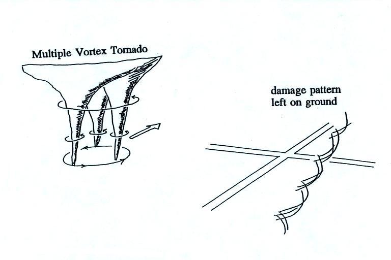
Some
big
strong
tornadoes
may
have
smaller more intense "suction
vortices" that spin around the center of the tornado. Tornado
researchers have actually seen the pattern shown at right
scratched into the ground by the multiple vortices in a strong tornado.
The
sketch above shows a tornado located SW of a neighborhood.
As
the
tornado
sweeps
through
the
neighborhood,
the
suction
vortex
will
rotate
around
the
core of the tornado.
The
homes
marked
in
red
would
be
damaged
severely.
The
others
would receive less damage. Remember that there are multiple
suction vortices in the tornado, but the tornado diameter is probably
larger than shown here.