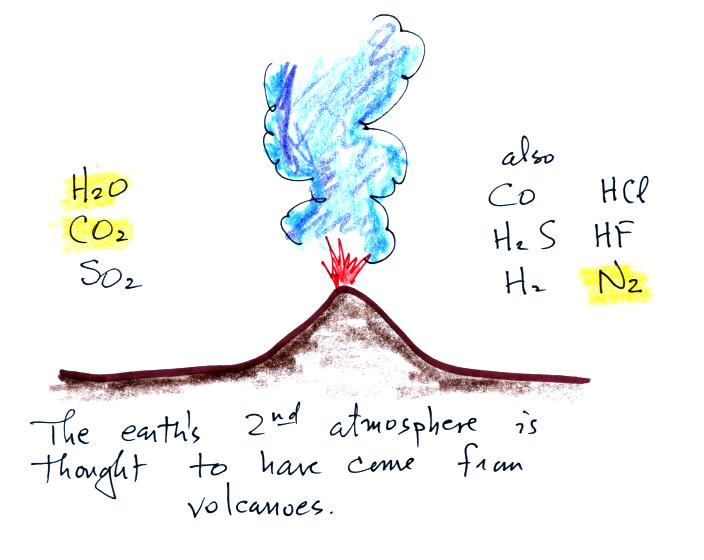
Thursday Aug. 25, 2011
click here to download today's notes in a more printer friendly format

Got to class this morning and found all the lights off and the Gallagher Theater was pitch black.  That meant slowly feeling my way to the front of the room and the light switches (if I only had a cell phone I could have used that as a flashlight).  There was still enough time for three songs from Brandi Carlile ( "Turpentine", "My Song", and "The Story"). 

50 sets of Experiment #1 materials were handed out today (I'll try to bring a few additional materials next Tuesday).  And I have to say you did a good efficient job of picking up the materials.  Signup sheets for the remaining experiments passed out in class.  Names from these signup sheets will be transferred to the online Report Signup Lists.


With Hurricane Irene threatening much of the East Coast, how about a Graphic of the Day (from the National Hurricane Center) in lieu of a Picture of the Day.  And perhaps an easy to remember version of the Saffir-Simpson scale.


The Saffir Simpson scale is used to rate hurricane intensity and damage potential.  The scale runs from 1 to 5.  Hurricanes with a Category 3 rating or above are considered major hurricanes.  Hurricane Irene is currently just barely a Category 3 but, at one point, was expected to intensity to Category 4.  It is also a large storm with hurricane and tropical storm force winds extending out 70 miles and 290 miles, respectively, from the center of the storm.  Winds must reach 75 MPH in order for a hurricane be considered a hurricane (Pt. 2). 

The storm surge is a rise in ocean level as a hurricane approaches a coastline and comes onshore (Pt. 1 above).  This is perhaps the greatest hazard from the hurricane along a coastline.  Note how, for every increase in level, windspeeds increase by about 20 MPH (that's only true on this easy to remember version of the scale).  We'll add the pressure values later in the semester.


We reviewed some of the material in the Tue. Aug. 23 online notes because a lot of students have added this class in the last day or two.  For example, here are the two "jobs" of the dew point temperature.


In Tucson, for much of the year,  dew points fall between 25 and 45 F and the air is dry.  During the summer monsoon the air is moister and dew points usually fall between 55 and 65 F.

Not too long ago the dew point was used to determine the start of the summer monsoon (the summer thunderstorm season) in Tucson.

The term monsoon is often used incorrectly in Tucson to just refer to a thunderstorm.   Monsoon actually refers to a shift in wind direction. 


Most of the year winds blow into Arizona from the west.  This air is relatively dry because the winds originate over relatively cool ocean water and then must blow up and over mountains along the coast.   Later in the semester, we will see that this movement over the mountains dries out the air (it's referred to the rain shadow effect and Arizona is on the dry (rainshadow) side of the mountains). 

During the summer the winds shift and start to come from the south and southeast.  This air is moister.  It is this increase in moisture that then makes thunderstorm development more likely.  Tucson normally gets about half its yearly precipitation during the 2 or 3 summer monsoon months (though we're not doing very well this year).


Meteorologists used to monitor the dew point to determine the start of the summer monsoon.  Since 2008 they made June 15 the official start of the monsoon.


Here's what happened this summer.  The daily average dew point crossed and remained above 54 F for the first time on July 3.  July 3rd was thus the start of the monsoon (using the pre 2008 definition).  Tucson had a nice thunderstorm on July 4 (that finished and moved out of the area before the nighttime fireworks).

The next figure (not shown in class because it's kind of ugly) shows you what the dew point has been doing this summer.  For the most part, once the summer monsoon got started, the dew point has remained fairly high (above 54 F).  Despite this fact, there hasn't been much rain (at least not in Tucson).  This demonstrates that moisture is just one of the ingredients needed for thunderstorm formation.  We'll learn about some of the other factors as we move on in the semester.


A student came up after class and asked about haboobs.  A haboob is a dust storm and is often caused by outflow winds from a thunderstorm.  It's a good and very relevant question because there were some spectacular examples of haboobs observed in the Pheonix area this summer and it's related to the summer monsoon and thunderstorms.  So here's a little additional information on this topic.


This figure shows some of the key features on a thunderstorm.  The flat top of a thunderstorm is called an anvil cloud (Pt. 1).  It forms because the thunderstorm has grown up to the top of the troposphere, the lowest layer in the atmosphere, and is trying to push into the stratosphere.  The stratosphere is very stable which makes it difficult for air to move vertically, it would rather move horizontally.  Lumpy looking clouds are sometimes seen on the bottom edge of the anvil cloud, these are mammatus clouds (Pt. 2). 

Mature thunderstorms, like the one drawn here, have both updrafts and downdrafts (Pt. 3).  The downdraft air reaches the ground (together with any precipitation falling from the storm) and spreads out sideways.  These surface winds created by the downdraft can be very strong, up to 100 MPH, and can cause a lot of damage.  An unusually strong downdraft is sometimes called a "downburst," "macroburst," or a "microburst."  The outward moving surface winds are also called "outflow."

The front edge of the outward moving surface winds is called a "gust front."  Because these winds will often kick up a lot of dust I tell students to remember the term "dust front."  Thunderstorm gust fronts likely produced the dust storms or haboobs that were observed in the Pheonix area this summer.

You'll find some good photographs in the Wikipedia article on haboobs.  Just about a week ago, surface winds from a strong microburst (an intense, narrow thunderstorm downdraft), caused damage on Ina Rd. near I-10 here in Tucson.  Here's a report from the National Weather Surface office in Tucson.  Toward the end of the report you'll find a photograph of the base of the thunderstorm (note the shaft of precipitation falling from the cloud) and photographs of the damage caused by the surface winds (uprooted trees and blown down power lines).  And here are a couple of videos of the July 5th, 2011, Pheonix haboob (video #1, video #2), one of the most spectacular this summer.


Now on to the main topic of the day.  The origin and evolution of our atmosphere.


The atmosphere we have today (mostly nitrogen, oxygen, water vapor, and argon) is very different from the earth's original atmosphere which was mostly hydrogen and helium.  This original atmosphere either escaped (the earth was hot and the gases were moving around with enough speed that they could overcome the pull of the earth's gravity) or was swept into space by the solar wind (click on the link if you are interested in learning more about the solar wind, otherwise don't worry about it). 

With the important exception of oxygen, most of our present atmosphere is though to have come from volcanic eruptions.


Don't worry about remembering all of the gases listed above.  Volcanoes emit a lot of water vapor and carbon dioxide.  As the earth began to cool the water vapor condensed and began to create and fill oceans.  Carbon dioxide dissolved in the oceans and was slowly turned into rock.  Smaller amounts of nitrogen (N2) are emitted by volcanoes.  Nitrogen is relatively unreactive and remained in the air.  Nitrogen concentration built up over time.  We'll learn a little more about sulfur dioxide when we cover air pollutants.

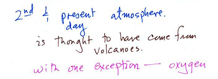
Volcanoes didn't add any of the oxygen that is today's atmosphere.  
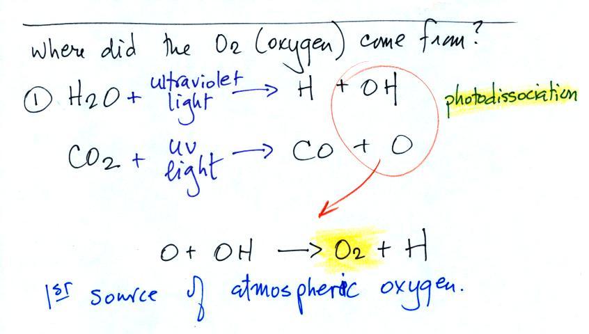
Where did that come from?


The oxygen is thought to have first come from photodissociation of water vapor and carbon dioxide by ultraviolet light (the high energy UV light is able to split the H20 and CO2 molecules into pieces).  The O and OH then react to form O2 and H.

By the way I don't expect you to remember the chemical formulas in the example above.  It's often easier and clearer to show what is happening in a chemical formula than to write it out in words.  If I were to right the equations down, you should be able to interpret them.  It's probably also good to remember that ultraviolet light is capable of breaking molecules apart (I think you'll see the dissociation reactions enough that you won't have any trouble remembering them).


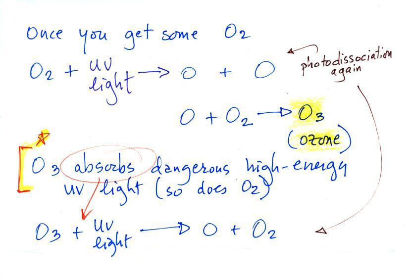
Once molecular oxygen (O2) begins to accumulate in the air UV light can split it apart to make atomic oxygen (O).  The atoms of oxygen can react with molecular oxygen to form ozone (O3). 

Ozone in the atmosphere began to absorb ultraviolet light and life forms could safely move from the oceans (which offered protection from UV light in the absence of ozone) onto land. 


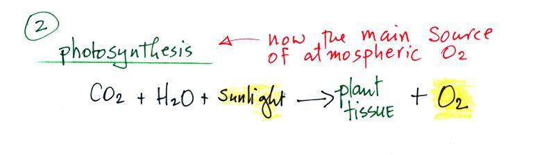
Photosynthesis is the 2nd (photodissociation of CO2 and H2O was the 1st) and now the main source of atmospheric oxygen. 

Note below that combustion is really just the opposite of photosynthesis.


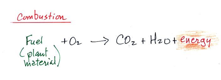
We burn fossil fuels (dead, undecayed plant material) to generate energy.  Water vapor and carbon dioxide are by products.  Combustion is a source of CO2.  We'll see these two equations again when we study the greenhouse effect (COis a greenhouse gas ) and global warming.


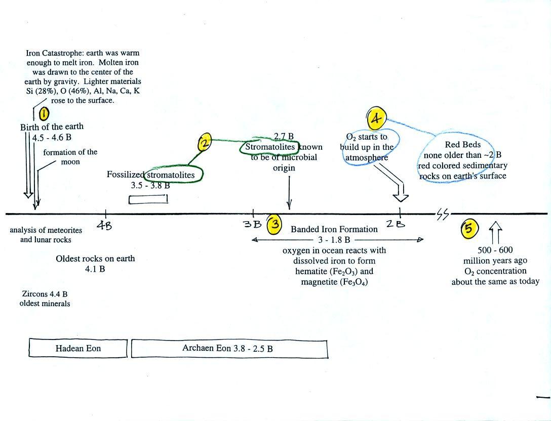
We had a quick look at the following figure (p. 1 in the packet of photocopied ClassNotes) which finished up this section on the origin and evolution of the earth's atmosphere.


This somewhat confusing figure shows some of the important events in the history of the earth and evolution of the atmosphere.  The numbered points were emphasized.
First, Point 1: the earth is thought to be between 4.5 and 4.6 billion years old.  If you want to remember the earth is a few billion years old that is probably close enough.
The iron catastrophe was an important event (but wasn't discussed in class).  Circulation of liquid metal in the core of the earth gives the earth a magnetic field.  The magnetic field deflects the solar wind around the earth.  Remember the solar wind may have swept away the earth's original atmosphere.
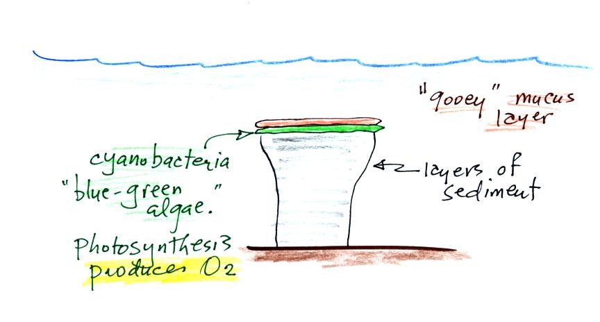
Stromatolites (Point 2) are column-shaped structures made up of layers of sedimentary rock.  They are created by microorganisms living at the top of the stromatolite (I've never actually seen a stromatolite, so this is all based on photographs and written descriptions).  Fossils of the very small microbes (cyanobacteria = blue green algae) have been found in stromatolites as old as 2.7 B years and are some of the earliest records of life on earth.  Much older (3.5 to 3.8 B years old) stromatolites, presumably also produced by microbes, but without microbe fossils, have been found. 


We're learning about stromatolites because the cyanobacteria were able to produce oxygen using photosynthesis.


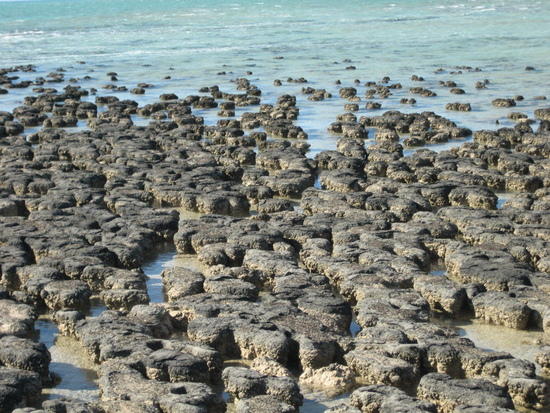
Living stromatolites are found in a few locations today.  The picture above is from Coral Bay Australia, located on the western tip of the continent.  The picture was probably taken at low tide, the stromatolites would normally be covered with ocean water.


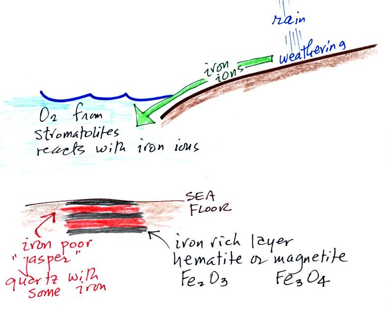
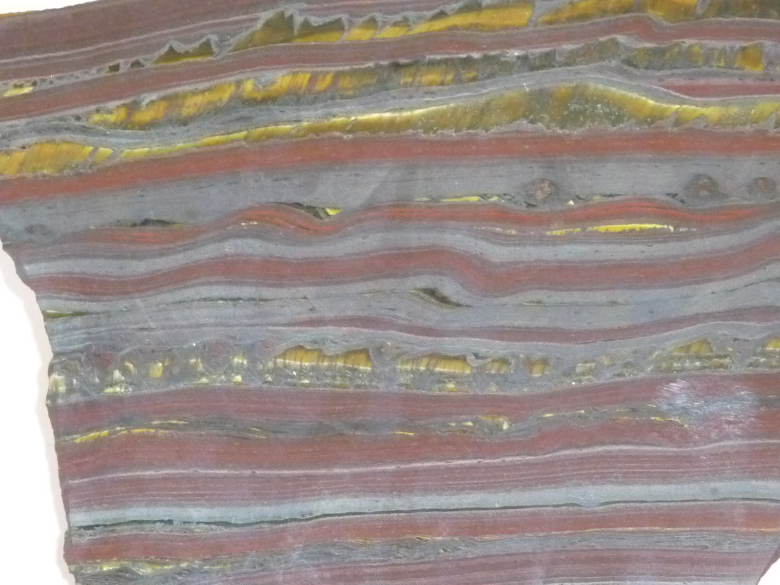
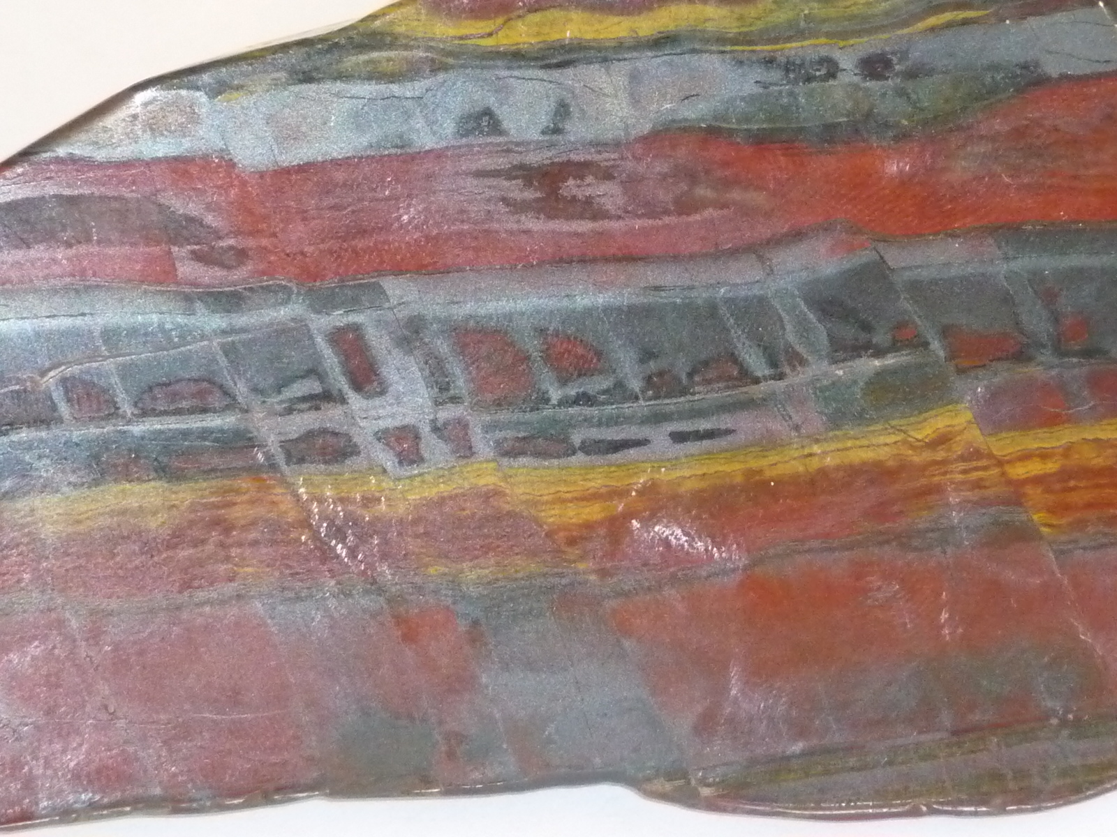
Once cyanobacteria began to produce oxygen in ocean water, the oxygen reacted with dissolved iron (iron ions in the figure below) to form hematite or magnetite.  These two minerals precipitated out of the water to form a layer on the sea bed.


Periodically the oxygen production would decrease or stop (rising oxygen levels might have killed the cyanobacteria or seasonal changes in incoming sunlight might have slowed the photosynthesis).  During these times of low dissolved oxygen concentrations, layers of jasper would form on the ocean bottom.  Eventually the cyanobacteria would recover, begin producing oxygen again, and a new layer of hematite or magnetite would form.  The rocks that resulted, containing alternating layers of black hematite or magnetite and red layers of jasper are known as the banded iron formation (Point 3).  A couple of small polished pieces of banded iron rock (actually "tiger iron", see photos below)  were passed around class (thanks for returning them).   In addition to the red and black layers, the tiger iron contains yellow layers made of fibers of quartz.   The rocks are fairly heavy because they contain a lot of iron, but the most impressive thing about them in my opinion is their age - they are a few billion years old!

Eventually the dissolved iron in the ocean was used up (Point 4 in the timeline figure above).  Oxygen produced by cyanobacteria no longer reacted with iron and was free to move from the ocean into the atmosphere.  Once in the air, the oxygen could react with iron in sediments on the earth's surface.  This produced red colored (rust colored) sedimentary rock.  None of these socalled red beds are older than about 2 B years old.  Thus it appears that a real buildup up oxygen began around 2 B years ago. Oxygen concentrations reached levels that are about the same as today around 500 to 600 years ago (Point 5 in the figure).


Photographs of the two samples of banded iron that are, perhaps, 3 billion years old.