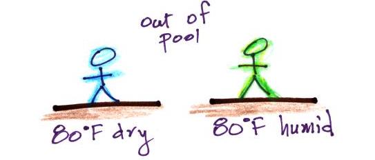
Evaporative
cooling will make you feel cold if
you get
out of a swimming pool on a warm dry day.
You won't feel as cold if the air is humid and the relative humidity is high. Sling psychrometers make use of this difference in cooling to measure relative humidity and dew point.
You won't feel as cold if the air is humid and the relative humidity is high. Sling psychrometers make use of this difference in cooling to measure relative humidity and dew point.
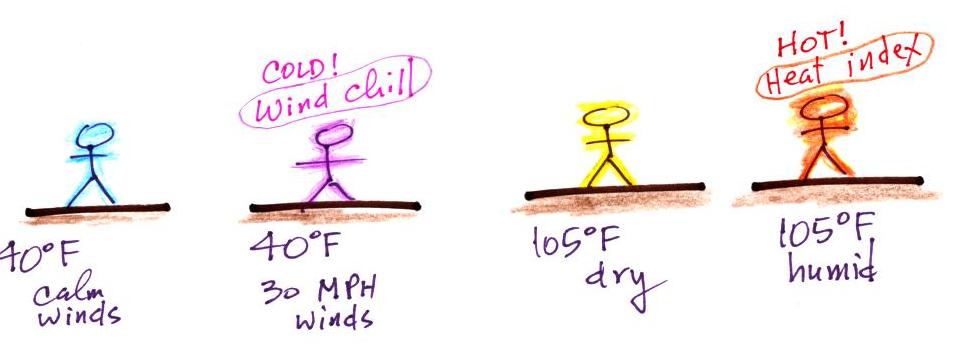
Going back to something we covered
earlier
in the semester. At left in the figure above a
40 F
day with 30 MPH winds will feel colder (because of
increased transport of energy away from your body by convection) than a
40 F
day
with no wind. The wind chill
temperature tells you how much colder it will feel ( a thermometer
would measure the same temperature on both the calm and the windy
day). If your
body isn't able to keep up with the heat loss, you can get hypothermia and
die.
Now something similar but new. Your body tries to stay cool by perspiring. You would feel hot on a dry 105 F day. You'll feel even hotter on a 105 F day with high humidity; your sweat won't evaporate as quickly. The heat index measures how much hotter you'd feel. The combination of heat and high humidity is a serious, potentially deadly, weather hazard because it can cause heatstroke (hyperthermia).
A short homemade video (my first actually) that showed how water vapor would, over time, preferentially condense onto small grains of salt rather than small spheres of glass. The figure below wasn't shown in class.
The following figure is at the bottom of p. 91 in the ClassNotes.
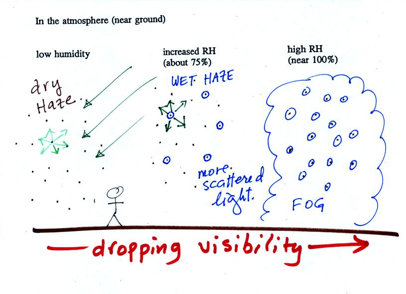
This figure shows how cloud condensation nuclei and increasing relative humidity can affect the appearance of the sky and the visibility.
The air in the left most figure is relatively dry. Even though the condensation nuclei particles are too small to be seen with the human eye you can tell they are there because they scatter sunlight. When you look at the sky you see the deep blue color caused by scattering of sunlight by air molecules mixed together with some white sunlight scattered by the condensation nuclei. This changes the color of the sky from a deep blue to a bluish white color. The more particles there are the whiter the sky becomes. This is called "dry haze." Visibility under these conditions might be a few tens of miles.
The middle picture shows what happens when you drive from the dry southwestern part of the US into the humid southeastern US or the Gulf Coast. One of the first things you would notice is the hazier appearance of the air and a decrease in visibility. Because the relative humidity is high, water vapor begins to condense onto some of the condensation nuclei particles (the hygroscopic nuclei) in the air and forms small water droplets. The water droplets scatter more sunlight than just small particles alone. The increase in the amount of scattered light is what gives the air its hazier appearance. This is called "wet haze." Visibility now might now be 10 miles perhaps a little less.
Finally when the relative humidity increases to 100% fog forms. Fog can cause a severe drop in the visibility. The thickest fog forms in dirty air that contains lots of condensation nuclei. That is part of the reason the Great London Smog of 1952 was so impressive. Visibility was at times just a few feet! We could see this effect in the cloud-in-a-bottle demonstration that was performed next.
Cooling air, changing relative humidity, condensation nuclei, and scattering of light are all involved in this demonstration.
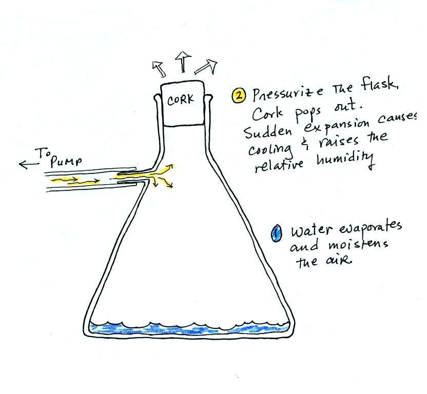
We used a strong, thick-walled, 4 liter flask (vaccum flasks like this are designed to not implode when all of the air is pumped out of them, they aren't designed to not explode when pressurized). There was a little water in the bottom of the flask to moisten the air in the flask. Next we pressurized the air in the flask with a bicycle pump. At some point the pressure blows the cork out of the top of the flask. The air in the flask expands outward and cools. This sudden cooling increases the relative humidity of the moist air in the flask to 100% ( probably more than 100% momentarily ) and water vapor condenses onto cloud condensation nuclei in the air. A very faint cloud became visible at this point.
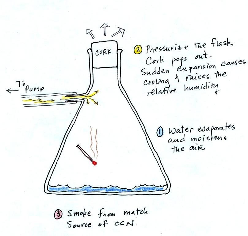
The demonstration was repeated an additional time with one small change. Two burning matches were dropped into the bottle. The smoke from the matches added lots of very small particles, condensation nuclei, to the air in the flask. The same amount of water vapor was available for cloud formation but the cloud that formed this time was quite a bit "thicker" and much easier to see.
This effect has some implications for climate change.
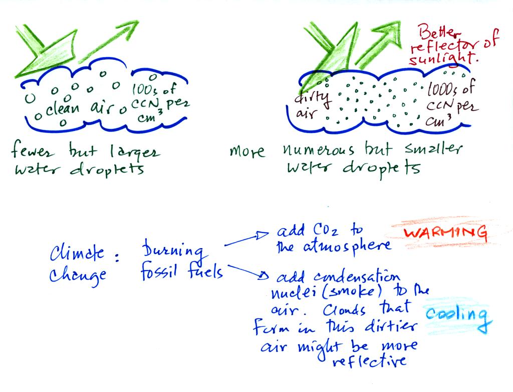
A cloud that forms in dirty air is composed of a large
number of small droplets (right figure above). This cloud is more
reflective
than a cloud that forms in clean air, that is composed of a smaller
number of larger
droplets (left figure).
Combustion of fossil fuels adds carbon dioxide to the atmosphere. There is concern that increasing carbon dioxide concentrations (and other greenhouse gases) will enhance the greenhouse effect and cause global warming. Combustion also adds condensation nuclei to the atmosphere (just like the burning match added smoke to the air in the flask). More condensation nuclei might make it easier for clouds to form, might make the clouds more reflective, and might cause cooling. There is still quite a bit of uncertainty about how clouds might change and how this might affect climate. Remember that clouds are good absorbers of IR radiation and also emit IR radiation.
Clouds are one of the best ways of cleaning the atmosphere
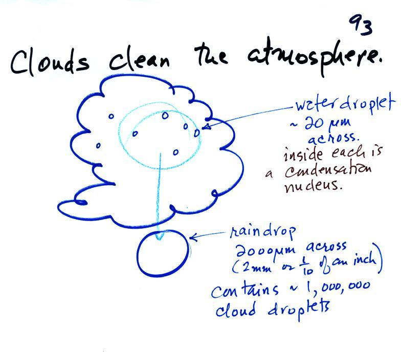
A cloud is composed of small water droplets (diameters of 10 or 20 micrometers) that form on particles ( diameters of perhaps 0.1 or 0.2 micrometers). The droplets "clump" together to form a raindrop (diameters of 1000 or 2000 micrometers which is 1 or 2 millimeters), and the raindrop carries the particles to the ground. A typical raindrop can contain 1 million cloud droplets so a single raindrop can remove a lot of particles from the air. You may have noticed how clear the air seems the day after a rainstorm; distant mountains are crystal clear and the sky has a deep blue color. Gaseous pollutants can dissolve in the water droplets and be carried to the ground by rainfall also. We'll be looking at the formation of precipitation late next week.
Here's a midterm grade summary example (numbers in the example are class averages)
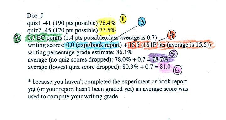
1. You should find your two quiz scores here. The quiz percentage grades are used to compute your overall grade; all the quizzes have the same weight.
2. This is the total number of extra credit points you have earned on the Optional Assignments. You could have earned up to 1.4 pts at this point in the semester. By the end of the semester that total will be at least 3 pts and maybe a little more.
3. If you have turned in an experiment or book report and it has been graded you should see the score here. If there is a 0 here, an average grade of 34 out of 40 has been used by the computer to show the effect of the experiment report on your overall grade. The Expt. #1 and Expt. #2 reports have been graded. The Expt. #1 revised reports haven't been graded yet.
4. This shows the total number of 1S1P pts you have earned so far (the computer in this case uses a 0 in the calculation if you haven't done any 1S1P reports). You should try to earn 45 1S1P pts by the end of the semester. Assignment #2 is currently available. There'll be another assignment after that.
The writing percentage grade is based on both the experiment report grade and the 1S1P pts total. It takes into account the fact that you couldn't have earned all of the 45 1S1P pts at this point in the semester.
5. This is the average that needs to be 90.0% or above in order for you to not have to take the final exam. Note the extra credit points are added on to the quiz + writing grade average.
6. This is the average with the lowest quiz score dropped. This is the grade that would be used together with your Final Exam score to determine your overall grade.
These mid term grade estimates try to give you an idea of the grade you would receive at the end of the semester if you continue to perform as you have done so far. It is possible for you to significantly raise your grade between now and the end of the semester. It is also possible, of course, for your grade to drop.
Please check your grade summary carefully for errors or omissions.
Now something similar but new. Your body tries to stay cool by perspiring. You would feel hot on a dry 105 F day. You'll feel even hotter on a 105 F day with high humidity; your sweat won't evaporate as quickly. The heat index measures how much hotter you'd feel. The combination of heat and high humidity is a serious, potentially deadly, weather hazard because it can cause heatstroke (hyperthermia).
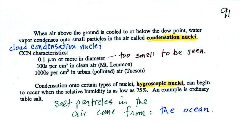
When the
relative humidity in air above the ground (and away from objects on the
ground) reaches 100%, water vapor will condense onto small particles
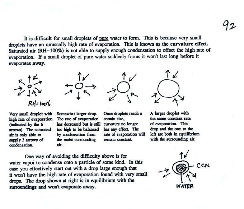
called condensation nuclei. It would be much harder for the water
vapor to just condense and form small droplets of pure water (you can
learn why that is so by reading the
top
of
p. 92 in the
photocopied class notes). There are always lots of CCN (cloud
condensation nuclei in the air) so this isn't an impediment to cloud
formation.
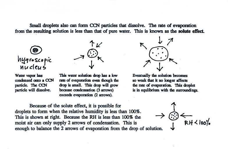
Water vapor will condense onto
certain kinds of condensation
nuclei
even when the relative humidity is below 100% (again you will find some
explanation of this on the bottom of p. 92).
These
are
called
hygroscopic
nuclei. Salt is an example; small particles of salt
mostly come from evaporating drops of ocean water.
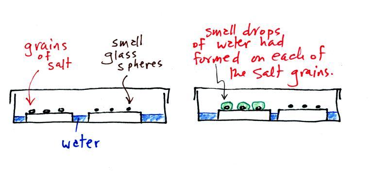
A short homemade video (my first actually) that showed how water vapor would, over time, preferentially condense onto small grains of salt rather than small spheres of glass. The figure below wasn't shown in class.
The start of the video at left
showed the small grains
of
salt were
placed on a platform in a petri dish
containing water. Some small spheres of glass were placed in the
same
dish. After about 1 hour small drops of water had formed around
each
of the grains of salt but not the glass grains (shown above at
right).
In humid parts of the US, water will condense onto the grains of salt in a salt shaker causing them to stick together. Grains of rice apparently absorb moisture which keeps this from happening and allows the salt to flow freely out of the shaker when needed.
In humid parts of the US, water will condense onto the grains of salt in a salt shaker causing them to stick together. Grains of rice apparently absorb moisture which keeps this from happening and allows the salt to flow freely out of the shaker when needed.
The following figure is at the bottom of p. 91 in the ClassNotes.
This figure shows how cloud condensation nuclei and increasing relative humidity can affect the appearance of the sky and the visibility.
The air in the left most figure is relatively dry. Even though the condensation nuclei particles are too small to be seen with the human eye you can tell they are there because they scatter sunlight. When you look at the sky you see the deep blue color caused by scattering of sunlight by air molecules mixed together with some white sunlight scattered by the condensation nuclei. This changes the color of the sky from a deep blue to a bluish white color. The more particles there are the whiter the sky becomes. This is called "dry haze." Visibility under these conditions might be a few tens of miles.
The middle picture shows what happens when you drive from the dry southwestern part of the US into the humid southeastern US or the Gulf Coast. One of the first things you would notice is the hazier appearance of the air and a decrease in visibility. Because the relative humidity is high, water vapor begins to condense onto some of the condensation nuclei particles (the hygroscopic nuclei) in the air and forms small water droplets. The water droplets scatter more sunlight than just small particles alone. The increase in the amount of scattered light is what gives the air its hazier appearance. This is called "wet haze." Visibility now might now be 10 miles perhaps a little less.
Finally when the relative humidity increases to 100% fog forms. Fog can cause a severe drop in the visibility. The thickest fog forms in dirty air that contains lots of condensation nuclei. That is part of the reason the Great London Smog of 1952 was so impressive. Visibility was at times just a few feet! We could see this effect in the cloud-in-a-bottle demonstration that was performed next.
Cooling air, changing relative humidity, condensation nuclei, and scattering of light are all involved in this demonstration.
We used a strong, thick-walled, 4 liter flask (vaccum flasks like this are designed to not implode when all of the air is pumped out of them, they aren't designed to not explode when pressurized). There was a little water in the bottom of the flask to moisten the air in the flask. Next we pressurized the air in the flask with a bicycle pump. At some point the pressure blows the cork out of the top of the flask. The air in the flask expands outward and cools. This sudden cooling increases the relative humidity of the moist air in the flask to 100% ( probably more than 100% momentarily ) and water vapor condenses onto cloud condensation nuclei in the air. A very faint cloud became visible at this point.
The demonstration was repeated an additional time with one small change. Two burning matches were dropped into the bottle. The smoke from the matches added lots of very small particles, condensation nuclei, to the air in the flask. The same amount of water vapor was available for cloud formation but the cloud that formed this time was quite a bit "thicker" and much easier to see.
This effect has some implications for climate change.
Combustion of fossil fuels adds carbon dioxide to the atmosphere. There is concern that increasing carbon dioxide concentrations (and other greenhouse gases) will enhance the greenhouse effect and cause global warming. Combustion also adds condensation nuclei to the atmosphere (just like the burning match added smoke to the air in the flask). More condensation nuclei might make it easier for clouds to form, might make the clouds more reflective, and might cause cooling. There is still quite a bit of uncertainty about how clouds might change and how this might affect climate. Remember that clouds are good absorbers of IR radiation and also emit IR radiation.
Clouds are one of the best ways of cleaning the atmosphere
A cloud is composed of small water droplets (diameters of 10 or 20 micrometers) that form on particles ( diameters of perhaps 0.1 or 0.2 micrometers). The droplets "clump" together to form a raindrop (diameters of 1000 or 2000 micrometers which is 1 or 2 millimeters), and the raindrop carries the particles to the ground. A typical raindrop can contain 1 million cloud droplets so a single raindrop can remove a lot of particles from the air. You may have noticed how clear the air seems the day after a rainstorm; distant mountains are crystal clear and the sky has a deep blue color. Gaseous pollutants can dissolve in the water droplets and be carried to the ground by rainfall also. We'll be looking at the formation of precipitation late next week.
Here's a midterm grade summary example (numbers in the example are class averages)
1. You should find your two quiz scores here. The quiz percentage grades are used to compute your overall grade; all the quizzes have the same weight.
2. This is the total number of extra credit points you have earned on the Optional Assignments. You could have earned up to 1.4 pts at this point in the semester. By the end of the semester that total will be at least 3 pts and maybe a little more.
3. If you have turned in an experiment or book report and it has been graded you should see the score here. If there is a 0 here, an average grade of 34 out of 40 has been used by the computer to show the effect of the experiment report on your overall grade. The Expt. #1 and Expt. #2 reports have been graded. The Expt. #1 revised reports haven't been graded yet.
4. This shows the total number of 1S1P pts you have earned so far (the computer in this case uses a 0 in the calculation if you haven't done any 1S1P reports). You should try to earn 45 1S1P pts by the end of the semester. Assignment #2 is currently available. There'll be another assignment after that.
The writing percentage grade is based on both the experiment report grade and the 1S1P pts total. It takes into account the fact that you couldn't have earned all of the 45 1S1P pts at this point in the semester.
5. This is the average that needs to be 90.0% or above in order for you to not have to take the final exam. Note the extra credit points are added on to the quiz + writing grade average.
6. This is the average with the lowest quiz score dropped. This is the grade that would be used together with your Final Exam score to determine your overall grade.
These mid term grade estimates try to give you an idea of the grade you would receive at the end of the semester if you continue to perform as you have done so far. It is possible for you to significantly raise your grade between now and the end of the semester. It is also possible, of course, for your grade to drop.
Please check your grade summary carefully for errors or omissions.