Tue. Sep. 14, 2010

A couple of songs from the Playing for Change/Song Around the World DVD.  The first was Don't Worry, the second was the best version of Stand By Me that I've ever heard (sorry that my laptop locked up before the end of the song).

Here is the Tue. Sep. 14 PowerPoint presentation in its entirety (note we didn't get past Slide #32)


Here are the figures that were drawn in class to accompany the PowerPoint presentation
The following figure should accompany Slide #5 in the PowerPoint.  It shows development of the geostrophic wind.

We start with some stationary air at Point 1.  The Pressure Gradient Force (the PGF is perpendicular to the contours and points toward low pressure) starts the air moving toward the top of the picture.

Once the air starts to move the CF appears (the CF is perpendicular to the wind and points to the right in the northern hemisphere) and starts to bend the air to the right.  The CF is weak at this point because the wind speed is low.

The wind is blowing a little faster at Point 2, the CF is stronger, the PGF still points toward the top of the picture.

The wind continues to speed up and turn to the right.  Eventually at Point 4 the wind is blowing parallel to the contours lines.  The PGF and CF are equal in strength and point in opposite directions.  They cancel each other out and the net force is now zero.  The wind will continue to blow in a straight line, parallel to the contour lines and at constant speed.

There was a question about the changing strength of the Coriolis force at about this point.


First the CF is perpendicular to the wind.  To the right of the wind (as you look downstream) in the northern hemisphere and to the left in the southern hemisphere.  The CF changes directions at the equator, so the CF must be zero at the equator.  It is strongest at the poles.

We drew in the directions of the PGF and the CF in the figure in Slide #8.


The contours in the following figure were oriented in a north-south direction.  Low pressure is on the left, high pressure on the right.  The winds is blowing from north to the south.  You were supposed to use this information to determine whether this is a northern or southern hemisphere map.


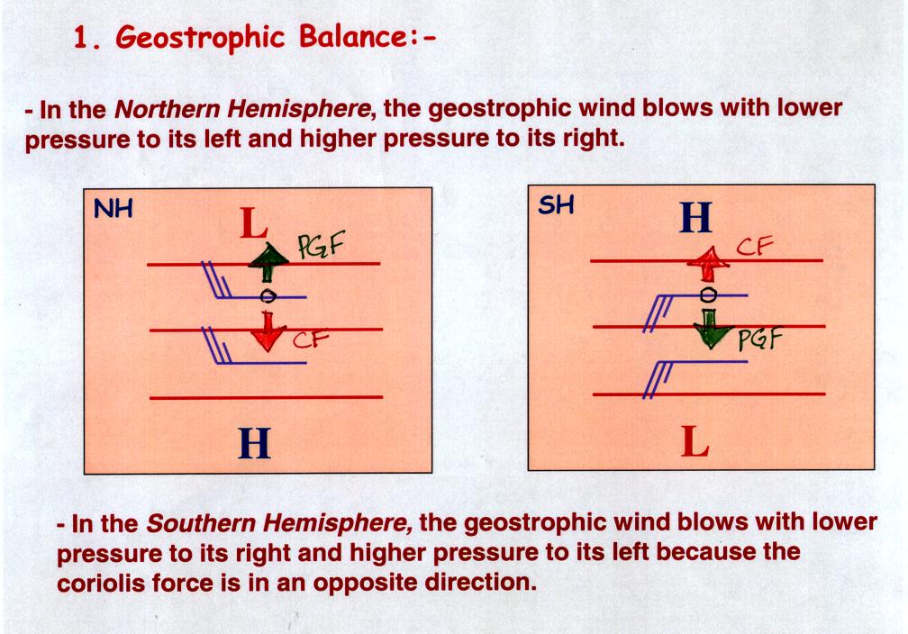
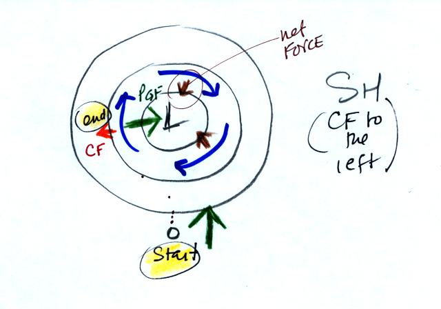
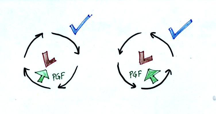
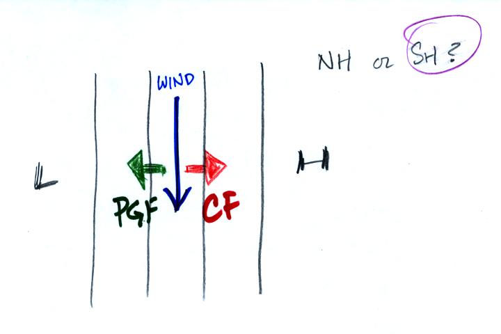
First draw in the PGF (perpendicular to the contours and pointing toward low pressure).  Then the CF must point in the opposite direction and be of equal strength in order to have zero net force.  In this case the CF points to the left of the wind (as you look downstream) so this must be a xouthern hemisphere chart.

This next figure reinforces the point presented on Slide #9 that the speed of the wind is determined by the contour spacing, i.e. by the strength of the PGF.

The contours are widely spaced in the top figure.  This produces a weak PGF and only a weak CF is needed to balance the PGF. In the bottom picture faster winds are needed in the lower figure to produce the stronger CF needed to balance the stronger PGF.

The concept of gradient flow is introduced in Slides 10-12.  In gradient flow winds blow parallel to curved or circular contours.  Since the wind changes direction a net force is needed.

Geostrophic flow is shown at the top for comparison (net force = 0, winds blow in a straight line parallel to the contours at constant speed)

A net inward force is needed to cause winds to blow in a circular path.  It doesn't matter if the wind is spinning around high or low pressure. 

A net force to the right or left of the wind is need to cause the wavy motion in the bottom figure.

The next figure shows the development of winds blowing around a circular upper level center of high pressure in the northern hemisphere.  This accompanies the discussion on Slides 13-15 in the PowerPoint presentation.

The air is stationary at the starting point above.  The PGF (green arrow) starts the air moving outward.  Once the wind starts to blow the CF causes the wind to turn to the right.  Eventually (end), the wind ends up blowing parallel to the contours in a clockwise direction around the high.  The inward pointing CF is stronger than the outward PGF.  The difference between the CF and the PGF gives the inward net force needed to keep the wind blowing in a circular path.

The next figure shows how winds start to blow around upper level low pressure in the northern hemisphere.  This accompanies Slides 16 &17 in the PowerPoint presentation.

Stationary air at the start moves inward and is then bent to the right by the CF.  The wind ends up blowing parallel to the contour lines in a counterclockwise direction.  The inward pointing PGF is stronger than the outward CF.  The net force is inward.

Here's the situation for low pressure in the southern hemisphere


It's very similar.  The only difference is that the CF causes the wind to turn left and end up blowing clockwise around the low pressure.

There are situations where the PGF is much stronger than the CF and the CF can be ignored.  A tornado is an example.  This is discussed on Slides 21-23 in the PowerPoint presentation.  Winds can blow around Low pressure because the PGF points inward.


The wind can spin in either direction in either hemisphere.
Without the CF winds can't spin around High pressure because there is nothing to provide the needed inward force.

You might already have heard that water spins in a different direction when it drains from a sink or a toilet bowl in the southern hemisphere than it does in the northern hemisphere.  You might also have heard that this is due to the Coriolis force or the Coriolis effect. 


There's just an inward pointing PGF, no CF.  Water can spin in either direction in either hemisphere.

Here is an optional homework that I sometimes assign in my sections of NATS 101.


We were starting to run out of time at this point.  Much of the information on Slides 25-32 were condensed onto the following two figures.  We really didn't have time to look at any of Slides 33-42.

We first looked at the effects of friction on surface winds.


We start in Fig. A with upper level winds blowing parallel to straight contours.

In Fig. B we add friction.  Friction always points in a direction opposite the direction of motion and slows down the wind.  Slowing the wind will weaken the CF

In Fig. C the CF is no longer able to balance the PGF.  The stronger PGF causes the wind to blow across the contours toward low pressure.

Finally in Fig. D we have a new balance.  Together the Friction and the CF balance the PGF.  The winds would blow in a straight line at constant speed across the contours toward low pressure.

We had time for one more figure, a summary of much of what we have learned today.

This figure shows surface and upper level winds blowing around centers of high and low pressure in the northern and southern hemisphere.

Pay attention to the direction of the spinning motions.  Surface winds blow across the contours, upper level winds blow parallel to the contours.

Note the distinction between converging and diverging surface winds.  The converging motions cause air to rise in surface centers of low pressure in both the northern and southern hemispheres.  Diverging winds create sinking air motions in surface centers of high pressure.

Rising and sinking air motions are important.  The following figure explains why (note the following figure wasn't shown or discussed in class).

Rising air moves into lower pressure surroudings (pressure decreases with increasing altitude).  The rising air expands and this expansion cools the air.  When you cool moist air enough (to the dew point) clouds can form.  Thus surface centers of low pressure are associated with stormy weather.

Sinking air is compressed as it moves into higher pressure surroundings closer to the ground.  This warms the air and keeps clouds from forming.  Thus you generally find clear skies with surface centers of high pressure.