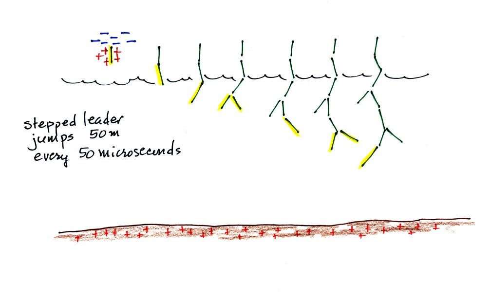
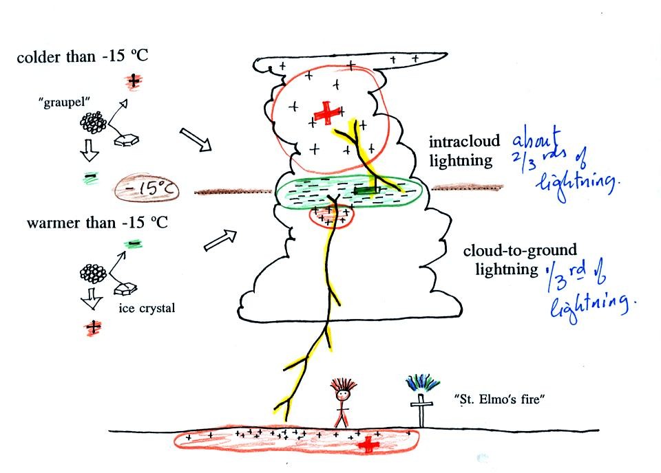
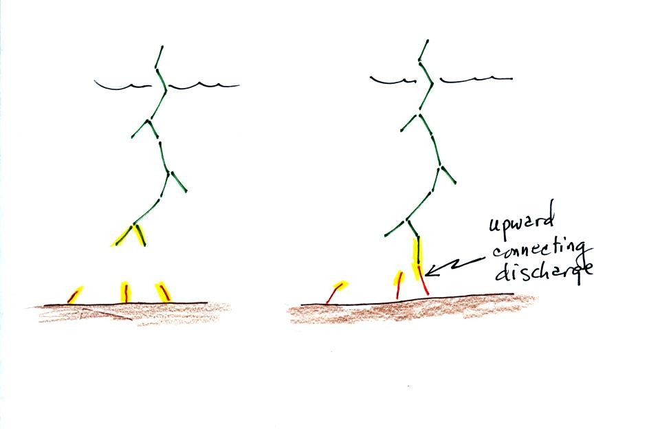
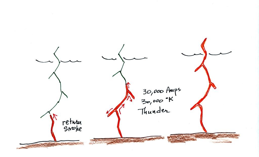
As the leader channel approaches
the ground strong electrical attraction develops between negative
charge in the leader channel and positive charge on the surface of the
ground. Several positively charged sparks develop and move
upward toward the stepped leader. One of these will intercept the
stepped leader and close the connection between negative charge in the
cloud and positive charge on the ground.
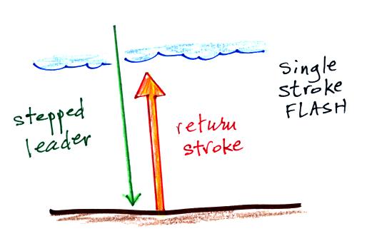
Many cloud-to-ground flashes end at
this point. In
about 50% of cloud to ground discharges,
the stepped leader-upward
discharge-return stroke sequence repeats itself (multiple times) with a
few subtle
differences.
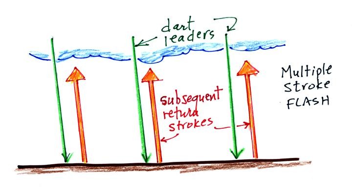
A downward dart leader travels from
the cloud to the
ground. The dart leader doesn't step but travels smoothly and follows
the channel created by the stepped leader (avoiding the
branches). It is followed by a slightly less powerful subsequent
return stroke that travels back up the channel to the cloud.
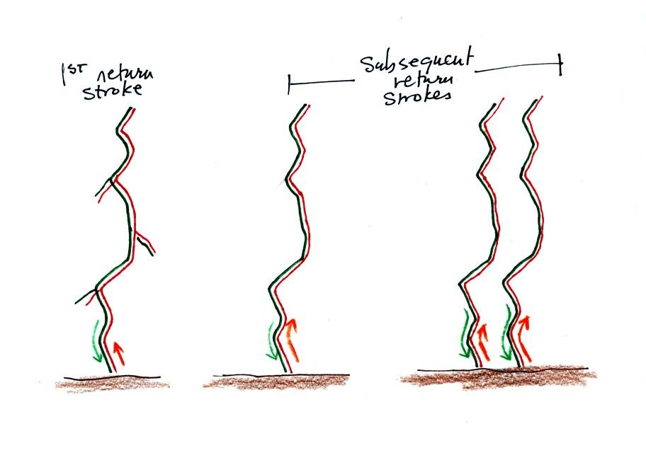
A normal still photograph would
capture the
separate
return strokes
superimposed on each other. If you bumped or moved the camera
during the photograph the separate return strokes would be spread out
on the image.
The image above shows a multiple stroke flash consisting of 4
separate
return strokes. There is enough time between separate return
strokes (around 1/10 th
second) that your eye can
separate the individual flashes of light.
When lightning appears
to flicker you are seeing the separate return strokes in a multiple
stroke flash. The whole flash usually lasts 0.5 to 1 second.
Here's a stepped
leader-upward connecting discharge-return
stroke
animation.
We also watched a fast time resolved video of an actual
stepped leader that is on YouTube
(http://www.youtube.com/watch?v=2XwFF5idD_0)
Here are
some unusual types of lightning.
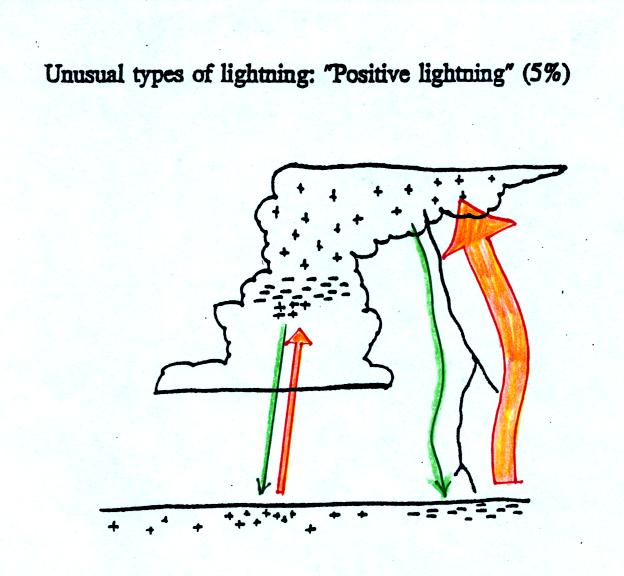
Occasionally a lightning
stroke will travel from the
positive charge
region in the top of the thunderstorm cloud to ground. These
types of strikes are more common at the ends of storms and in winter
storms. This is probably because the top part of the cloud gets
pushed sideways away from the middle and bottom portions of the
cloud. Positive strokes are very powerful. They sometimes
produce an unusually loud and long lasting clap of thunder.

Here's an even rarer form of
lightning. Lightning
sometimes starts at the ground and travels
upward.
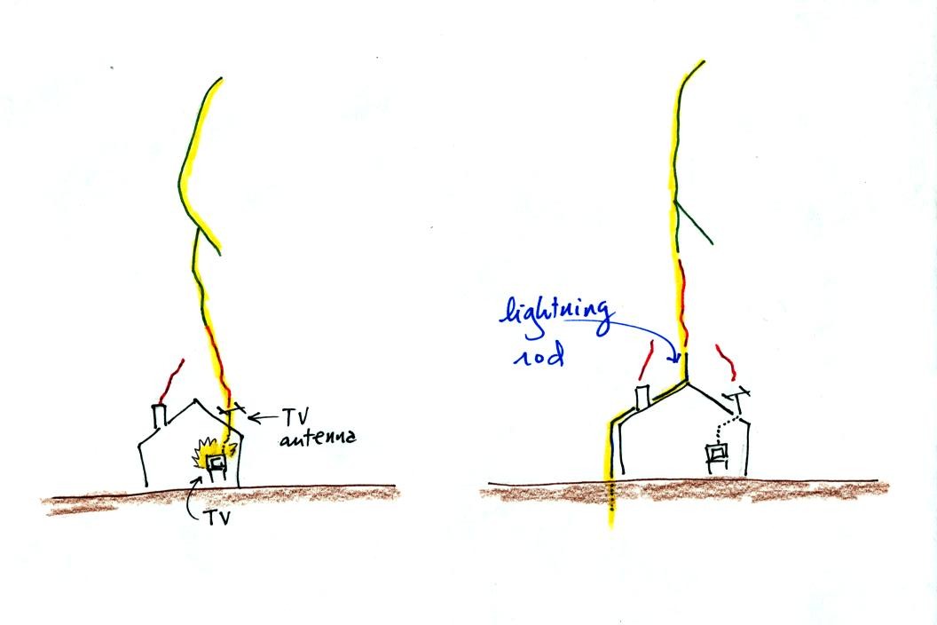
Upward lightning is generally only initiated by mountains and tall
objects such as a skyscraper or a tower of some kind. Note the
discharge is different in another way also. These
discharges are initiated by an upward leader. This is followed by
not by a return stroke but by a more normal downward leader. Once
the 2nd leader reaches the ground, an upward return stroke travels back
up the channel to the cloud.
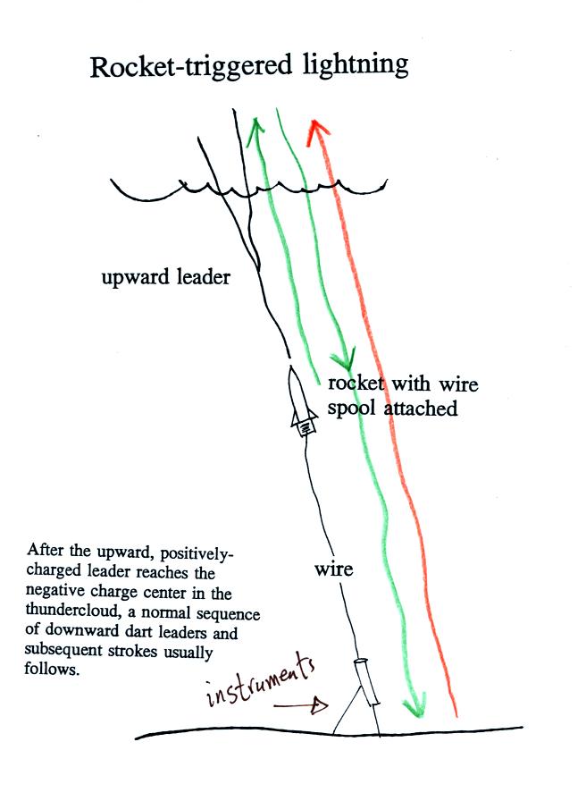
The fact that lightning could begin
with an upward discharge that
begins at the ground lead scientists to develop a technique to trigger
lightning by firing a small
rocket up
toward a thunderstorm. The rocket is connected by a thin wire to
the ground. When the rocket gets 50 to 100 m above the ground
upward lightning will develop off of the top of the wire.
Scientists are able to take closeup photographs and make
measurements
of lightning currents using triggered lightning. Triggered
lightning can also be used to test the operation of lightning
protection devices. A short video showing rocket triggered
lightning experiments being conducted in northern Florida was shown in
class.
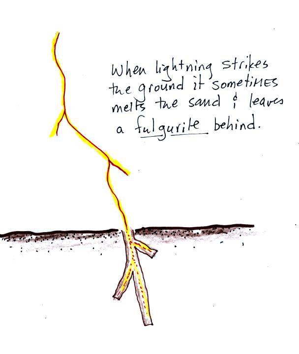
When
lightning strikes the
ground
it will often melt the soil
(especially sandy soil) and leave behind a rootlike structure called a
fulgurite. A
fulgurite is just a narrow (1/2 to 1 inch across) segment of melted
sand (glass). The video showed archaeology students excavating
around the lightning triggering site after the summer's
experiments. They were able to uncover and reveal a very long
(perhaps world record length) fulgurite. A couple of
small pieces of fulgurite were passed around class.
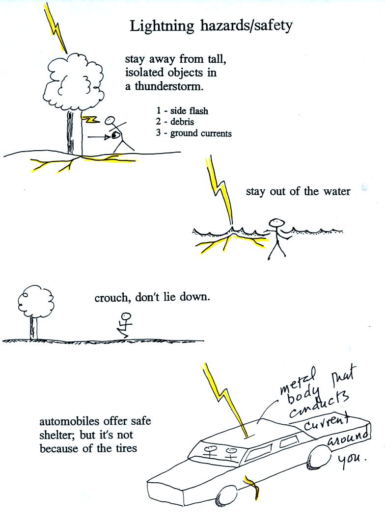
Lightning is a serious weather hazard and kills just under 100
people every year in the United States. We discussed some
lightning safety rules that you should keep in mind during
thundery weather.
Stay
away
from
tall
isolated
objects
during
a
lightning
storm.
You can be hurt or killed just by being close to a lightning strike
even if you're
not struck directly.
An
automobile
with
a
metal
roof and body provides good
protection from
lightning. The lightning current will travel through the metal
and around the passengers inside. The rubber tires really don't
play any role at all. The people in Florida that were
triggering lightning were inside a metal trailer and were perfectly
safe. All of the connections made to equipment outside the
trailer were done using fiber optics, there were no metal wires
entering
or leaving the trailer.
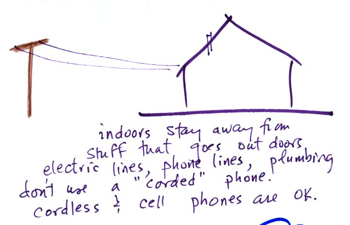
You shouldn't use a corded phone or electrical
appliances
during a lightning storm because lightning currents can follow wires
into your home. Cordless phones and cell phones are safe.
It is also a good idea to stay away from plumbing as much as possible
(don't take a shower during a lightning storm, for example). Vent
pipes that are connected to the plumbing go up to the roof of the
house which puts them in a perfect location to be struck.

