Wednesday Nov. 17, 2010
click here to download today's notes in a
more printer friendly format
A couple of songs from The Ragbirds ("Space"
and "Roar, Claw,
and Bite"). This is a group that a NATS 101 student said I
might like and she was right.
The 1S1P "Record Setting Storm" reports have been graded and were
returned in class today.
The Quiz #4 Study Guide pt. 1 is now
available.
We started today by looking at some
of the conditions that can lead to severe thunderstorm
formation. Severe last
longer, grow bigger, and become stronger than ordinary air mass
thunderstorms.
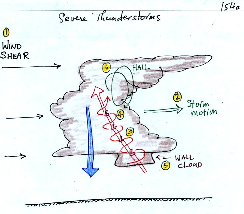
Severe
storms are more likely to form when there is vertical wind shear.
Wind
shear (pt 1) is changing wind direction and/or wind speed with
distance. In
this case, the wind speed is increasing with increasing altitude, this
is vertical wind shear.
A thunderstorm that forms in this kind of an environment
will move at an average of the speeds at the top and bottom of the
cloud (pt.
2).
The thunderstorm will move to the right more rapidly than the air at
the ground
which is where the updraft begins. Rising air that is situated at
the
front bottom edge of the thunderstorm will find itself at the back edge
of the
storm when it reaches the top of the cloud.
This produces a
tilted
updraft (pt. 3). The downdraft is situated at the back of the
ground. The updraft is continually moving to the right and
staying away
from the downdraft. The updraft and downdraft coexist and do not
"get in each others way." If you remember in air mass
thunderstorms, the downdraft gets in the way of the updraft and leads
to dissipation of the storm.
Sometimes
the
tilted
updraft
will
begin to rotate. A rotating
updraft is
called a mesocyclone
(pt. 4). Meso refers to medium size
(thunderstorm size)
and cyclone
means winds spinning around low pressure. Low pressure in the
core of the
mesocyclone creates an inward pointing
pressure
gradient force needed to keep the updraft winds spinning in circular
path (low
pressure also keeps winds spinning in a tornado).
The cloud that
extends
below the cloud base and surrounds the mesocyclone
is
called a wall cloud (pt.
5). The largest and strongest tornadoes
will
generally come from the wall cloud.
Note (pt. 6) that a tilted updraft provides a way of keeping growing
hailstones
inside the cloud. Hailstones get carried up toward the top of the
cloud
where they begin to fall. But they then fall
back into
the strong core of the updraft and get carried back up toward the top
of the
cloud.
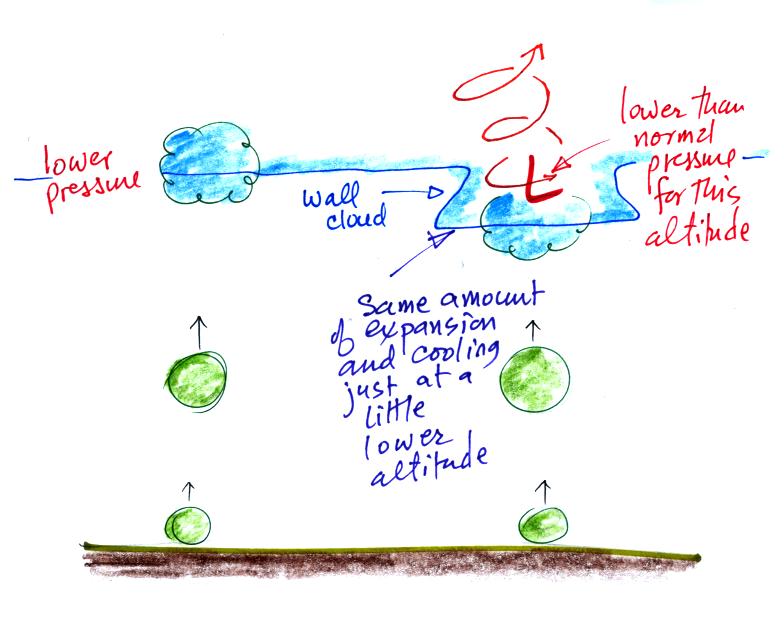
A wall cloud can form a little bit
below the rest of the base of the thunderstorm. The figure above
tries to explain why that is true. Clouds normally form when air
rises, expands, and cools as shown above at left. The rising air
expands because it is moving into lower pressure surroundings at higher
altitude.
At right the air doesn't have to rise to as high an altitude to
experience the same amount of expansion and cooling. This is
because it is moving into the core of the rotating updraft where the
pressure is a little lower than normal for this altitude. Cloud
forms a little bit closer to the ground.
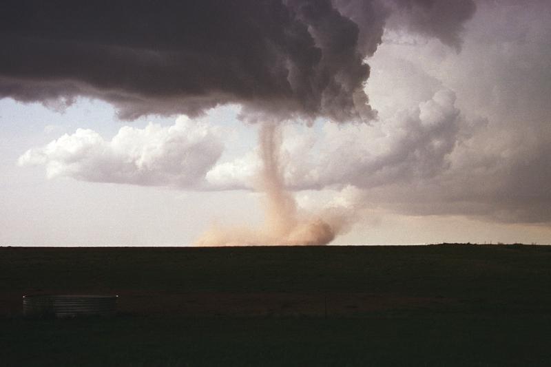
Here's a
pretty nice photograph of a wall cloud and what is probably a
relatively weak tornado (from the
University
Corporation for Atmospheric Research)
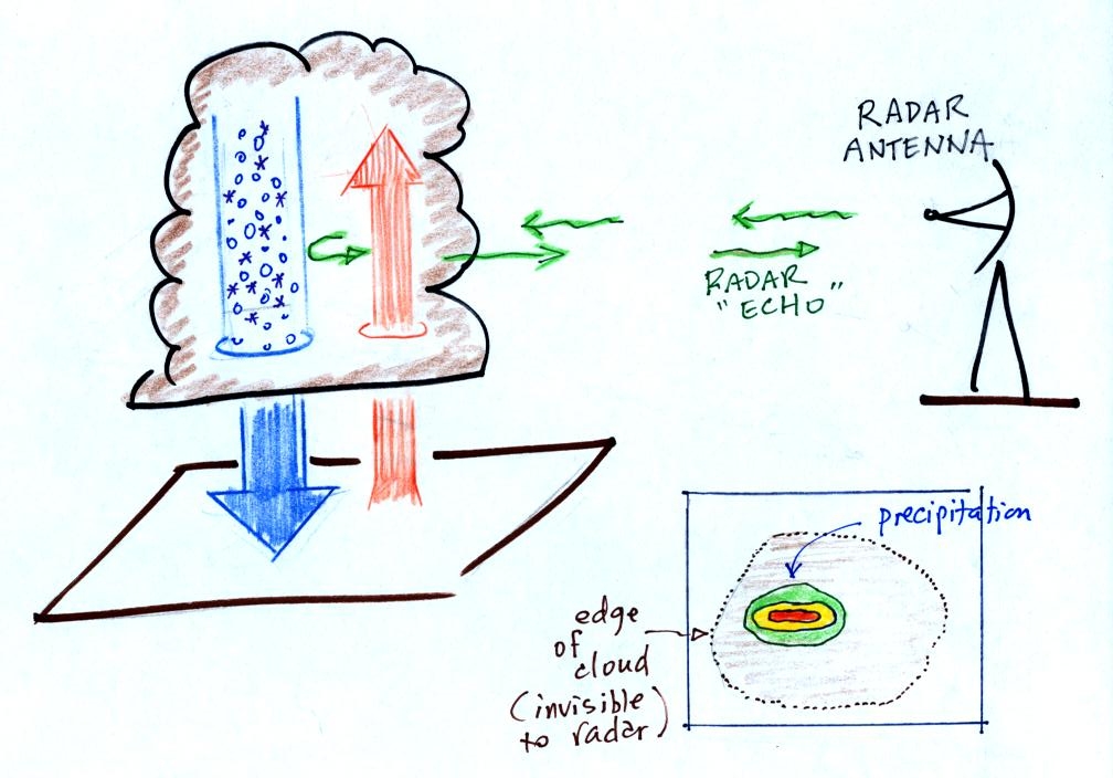
Thunderstorms
with rotating updrafts often have a distinctive radar signature called
a hook echo.
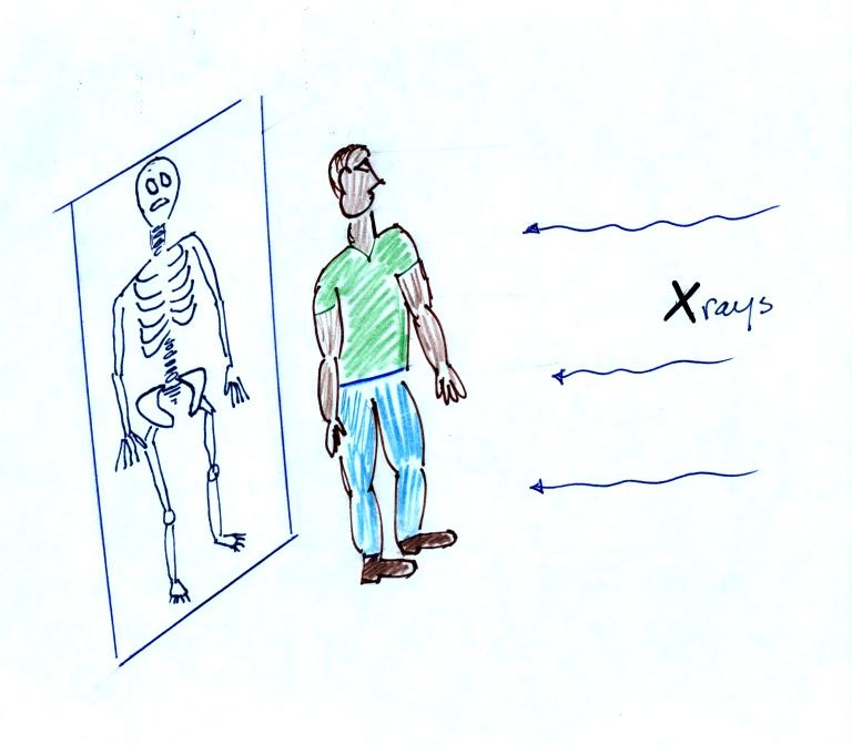
We haven't
discussed weather radar
in this class. In some ways a radar image of a thunderstorm is
like an
X-ray photograph of a human body. The Xrays
pass through the flesh but are partially absorbed by bone.
Xrays reveal the skeletonal
structure inside a body.
The
radio signals
emitted by radar
pass through the cloud itself but are reflected by the much larger
precipitation particles. The intensity of the reflected signal
(the echo) is color coded. Red means an intense reflected signal
and lots of large precipitation particles. The edge of the cloud
isn't normally seen on the radar signal.
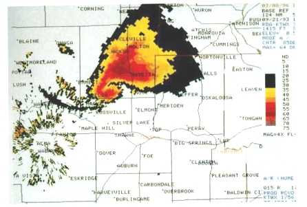
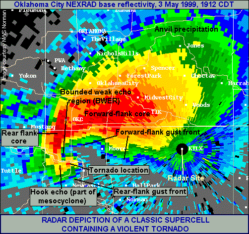
Here are some actual radar images with prominent
hook echoes.
This is
the radar image of a thunderstorm that produced a very strong tornado
that hit Oklahoma
City in May
1999 . The hook echo is visible near the lower left hand
corner of the picture. Winds in the tornado may have
exceeded 300 MPH.
This
seemed like a good place to briefly discuss supercell thunderstorms.
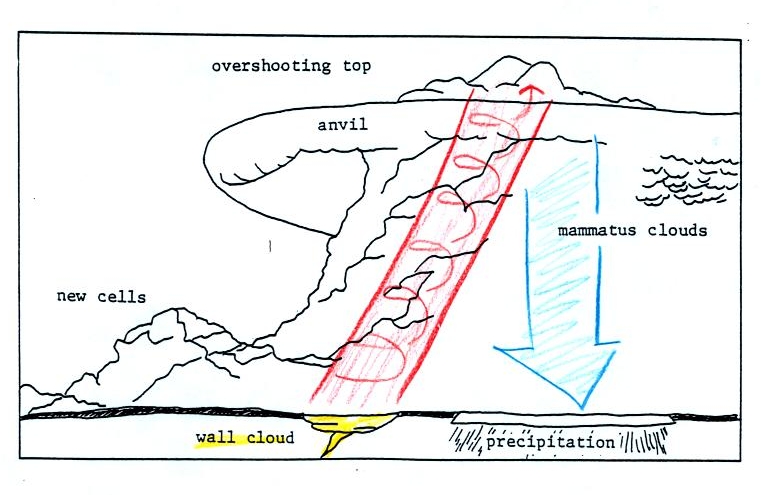
Here is a
relatively simple
drawing showing some of the key features on a supercell
thunderstorm. In a supercell the
rotating
updraft (shown in red above) is strong enough to penetrate into the
stratosphere. This produces the overshooting top or dome feature
above. A wall cloud and a tornado are shown at the bottom of the mesocyclone. In an ordinary thunderstorm
the updraft
is unable to penetrate into the very stable air in the stratosphere and
the
upward moving air just flattens out and forms an anvil. The
flanking line
is a line of new cells trying to form alongside the supercell
thunderstorm.
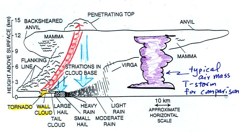
Here
is a second slightly more complicated drawing of a supercell
thunderstorm. A typical air mass thunderstorm (purple) has been
drawn in
for comparison.
A short segment
of video was shown at this point. The video first showed some
good quality video of a close tornado. This was
followed by photographs of
a distant supercell thunderstorm and photographs of the bases of nearby
supercell thunderstorms. Here you could see the spectacular wall
cloud that often forms at the base of these storms. Finally a
computer simluation showed some of the complex motions that form inside
supercell thunderstorms, particularly the tilted rotating updraft.
Next it
was time for some
introductory information on tornadoes.
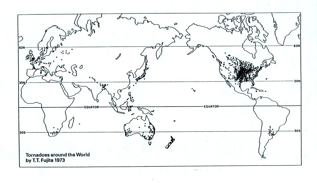
The United
States has more tornadoes in an
average year than
any
other country in the world (over 1000 per year). The
central
US
has
just
the
right
mix
of
meteorological
conditions.
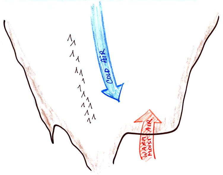
In the spring, cold dry
air can move all the way
from
Canada and collide with
warm moist air
from the Gulf of Mexico to form strong cold fronts and thunderstorms.
Tornadoes
have been
observed in
every state in the US, but tornadoes are most frequent in the central
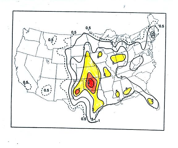
plains, a region referred to as "Tornado Alley" (highlighted in red,
orange, and yellow above). You'll
find this map on p. 161 in the photocopied ClassNotes)
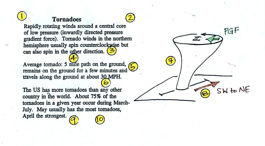
Here are some basic
tornado
characteristics. (the
numbering in the figure above may differ slightly from what we did in
class)
1. About 2/3rds of tornadoes
are F0 or F1 tornadoes (we'll learn about the Fujita scale used to rate
tornado intensity on Thursday) and have spinning
winds of
about 100 MPH or less. Microburst winds can also reach 100
MPH. Microbursts are much more common in Tucson in the summer
than tornadoes and can inflict
the same level of damage.
2. A very strong inwardly directed pressure
gradient force is needed to keep winds spinning in a circular
path. The
PGF is much stronger than the Coriolis Force (CF) and the CF can be
neglected.
The pressure in the center core of a tornado can be 100 mb less than
the pressure in the air outside the tornado. This is a very large
pressure difference in such a short distance.
3. Tornadoes can spin clockwise or
counterclockwise, though
counterclockwise rotation is more common.
4, 5, 6. Tornadoes usually last only a few
minutes, leave a path
on the ground that is a few miles
long, and move at a few 10s of MPH. We will look at an exception
on Friday.
7, 8. Most tornadoes
move from the SW toward the NE. This is because tornado-producing
thunderstorms are often found just ahead of a cold front. Winds
ahead of a cold front often blow from the SW. Most
tornadoes
have
diameters
of
tens
to
a
few
hundred yards but tornadoes with
diameters over a mile have been observed.
9, 10. Tornadoes
are
most
frequent
in
the
Spring.
The
strongest
tornadoes also occur at
that time of year. Tornadoes are most common in the late
afternoon when the atmosphere is most unstable.