The following material was covered in class on Tue. Oct. 9 but,
because it is fairly confusing and takes some time to sort through and
understand, it wasn't on Quiz #2. We might have a vote in class
to determine whether it should be covered on Quiz #3 or not.
Sun path
diagrams are a way of showing the path that you would see the sun
follow during the day. We'll look at how the sun's path changes
during the course of the year at Tucson, and we'll also see how the
sun's path is different at different locations on the globe.
We'll come to understand better why the largest seasonal changes
(biggest differences between summer and winter) are found at high
latitude and why there is very little seasonal change at the equator.
The poles (the South Pole in particular because it is land) are the
coldest locations on earth. The hottest locations on earth aren't
found at the equator as you might expect rather near 30 latitude.
The situation is probably the simplest on the equinoxes, we'll start
there. This is covered on p. 77a in the photocopied Class Notes.
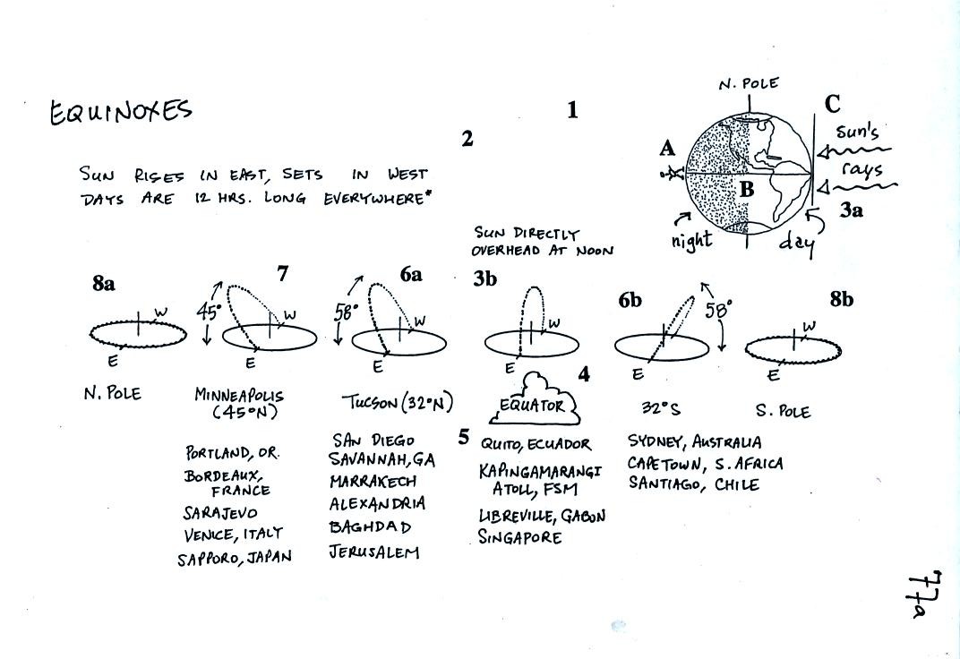
There is a lot of information on this figure. We
worked
through this figure numbered point by numbered point. You'll find
written explanations of each point below and on p. 77b in the
photocopied notes.
Notice first of all that the line separating day from night
passes through the poles. That is how you know this is one of the
equinoxes and not the summer or winter solstice.
1. The
line separating day from night passes through the north and south
poles. As the earth spins on its axis, a person standing anywhere
on the globe will spend exactly half the day on the nighttime side of
the picture and half the day on the daytime side of the picture.
Thus the day and night are both 12 hours long. This is true
everywhere except at the poles. We'll see what happens at the
poles later.
2.
Imagine standing at the equator. At point A you are positioned in
the middle of the nighttime side of the globe; it is midnight at Point
A. 6 hours later you will be standing at Point B where you will
move from night to day; this is sunrise. To see the sun you must
look exactly back along one of the rays of light coming from the
sun. You must turn and look straight east to do this. One
the equinoxes, the sun will rise in the east (not just somewhere in the
east but exactly due east). This only happens on the spring and
fall equinox. The rest of the year the sun will rise south or
north of east.
3. Six
hours later you arrive at Point C; it is noon. Now to see the sun
you must tilt your head and look straight overhead. The sun
passes directly overhead at noon at the equator on the equinoxes.
THe picture above shows the earth viewed from outer space. We
will next look at the sun's path in the sky viewed from the ground
where most of us will spend our entire lives.
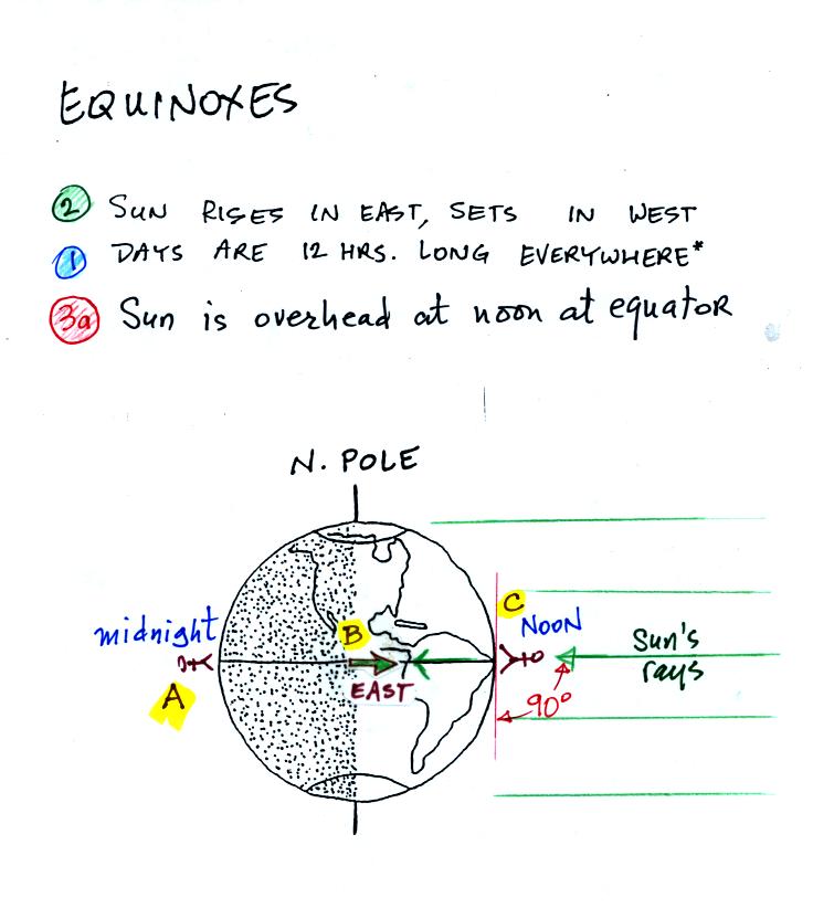
3.
This
shows the path of the sun at the equator. The sun rises in the
east at 6 am, passes
directly overhead at noon, and sets in the west at 6
pm.
4. The
cloud shown next to Point 4 above refers to a band of clouds that
circles the globe at the latitude where the sun passes overhead at
noon. This marks the position of the "intertropical convergence
zone (ITCZ)"; we'll learn more about the ITCZ later in the
semester. You can usually make out this band of clouds on a global
satellite picture. At the present time, just a couple of
weeks after the fall equinox the band of clouds is near the
equator. It
will move south of the equator as we get closer to the winter
solstice. Then it will move back to the equator by next March and
move into the northern hemisphere next summer.
5. A
list of few cities that are located on or very close to the equator.
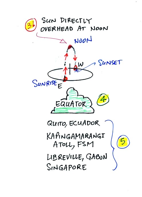
6a.
This sun path diagram shows the path that the
sun follows in the sky on the equinoxes in Tucson (or another city
located at 32o N latitude). The sun rises in the east
(just like
it does elsewhere on the globe) at around 6:30 local time (the precise
time depends on your location within a time zone), reaches its
highest point in the sky (58o above the southern horizon)
just after noon and sets in the west at about 6:30 pm.
Because the sun rises in the east and sets in the west, crossing an
east-west oriented street near sunrise or sunrise can be dangerous
around the times of the equinoxes.

In this case the car driver would have had the sun shining
directly in
his/her eyes and might really not have seen the pedestrian crossing the
street.
6b.
Sydney Australia is located at 32o
S latitude. In
the southern hemisphere the sun rises in the east, travels into the
northern sky and then
sets in the west.
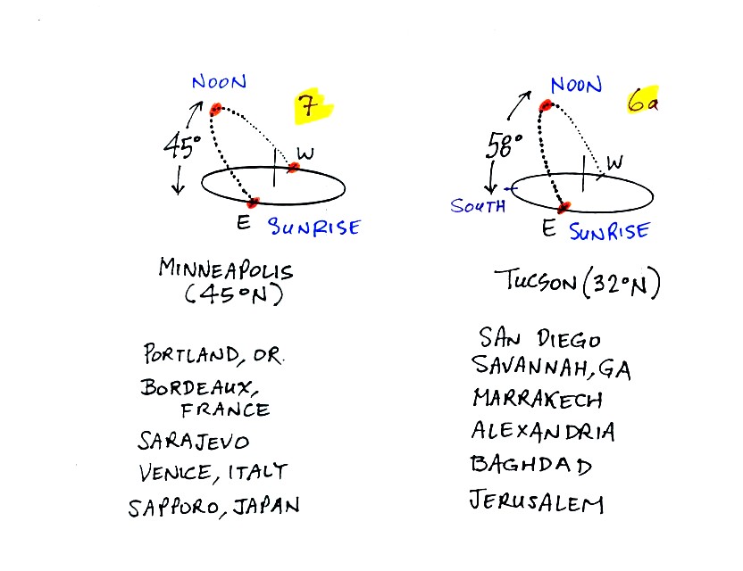
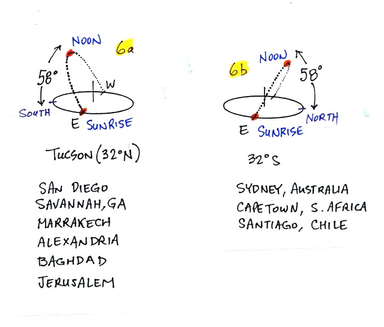
7.
At Minneapolis the sun rises in the east,
doesn't get quite as high in the sky at noon (only 45o above
the
southern horizon) and sets in the wet. Even though the sun shines
for the same amount of time in Minneapolis as it does in Tucson (12
hours), Minneapolis will receive less energy during the day because of
the lower elevation angle. Remember that when the sun is low in
the sky the sun's rays must pass through a longer path of
atmosphere. A larger percentage of the sunlight is absorbed and
reflected. Once this attenuated sunlight reaches the ground it
illuminates a larger area on the ground.
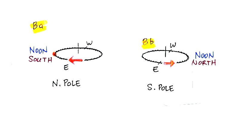
8a.
At the north pole the sun really
doesn't rise or set. At 6 am you would find the sun right on the
horizon in the east. At noon it would be positioned in the
south. The sun
would be visible at midnight in the north.
8b.
The
sun also circles the sky at the horizon at the south pole. It
just
travels in the opposite direction than at the north pole.
The winter
solstice is just over 2 months from now, we'll cover that next.
You'll find a detailed discussion of all the numbered points
above on p. 78b in the photocopied Class Notes.
Rather than go over all of that again we'll review the main
points. The figures below
differ from those shown in class.
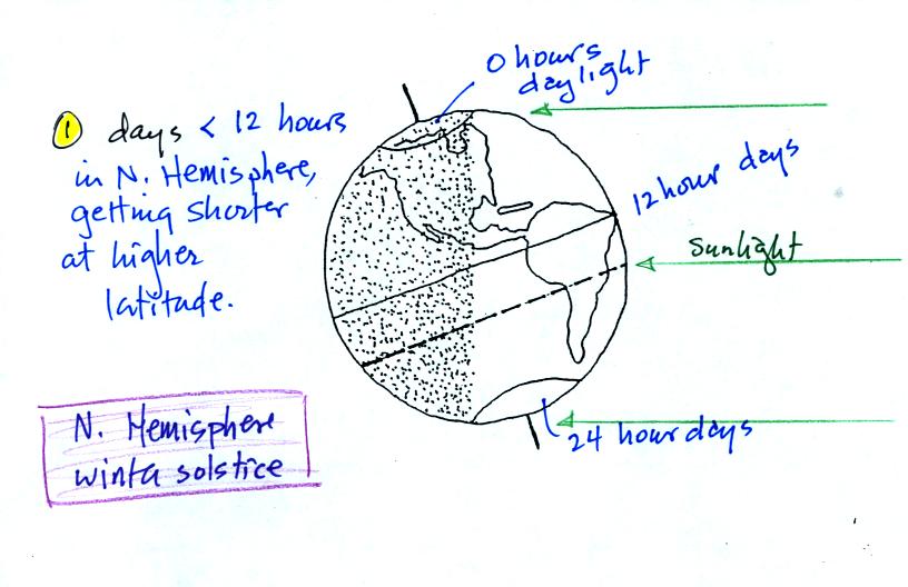
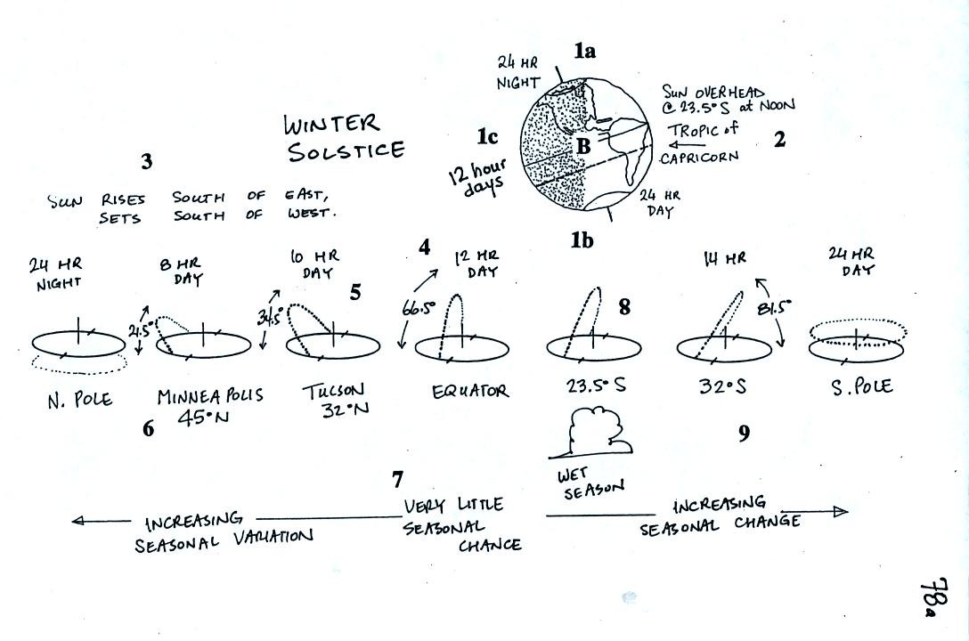
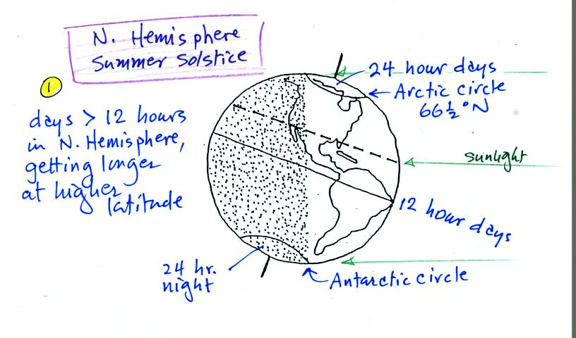
The North Pole is tilted away from the sun. There are
0 hours of daylight, 24 hours of night everywhere north of 66.5 N
latitude (the Arctic Circle). There are 24 hours of daylight
south 66.5 S
latitude (the Antarctic Circle). The equator is halfway between
the poles, the days are
12 hours long at the equator. Days are less than 12 hours long in
the Northern Hemisphere. Days get shorter and shorter as you move
from the equator to higher northern latitude.
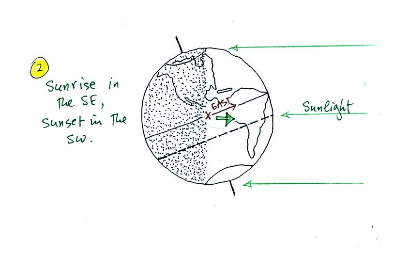
On the winter solstice you need to turn to the southeast to
see the sun
rise. The sun sets in the southwest.
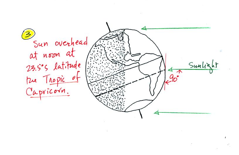
The sun will pass overhead at noon at 23.5 S latitude, at
the Tropic of
Capricorn.
Next we will compare the sun's path in the sky in Tucson on the Winter
Solstice (left figure below) and the Equinox (right figure).
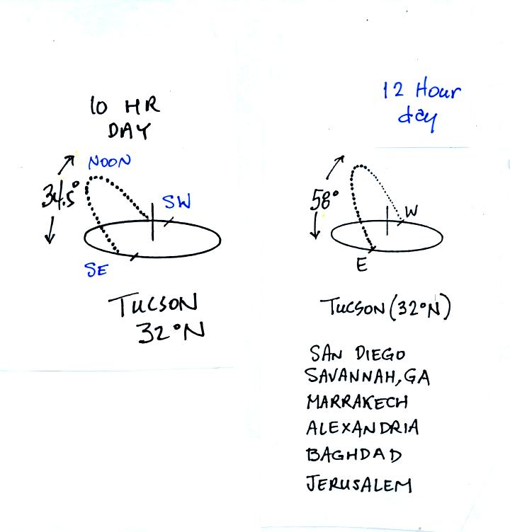
On the equnoxes the days are 12 hours long and the sun rises to about
60 degrees above the southern horizon at noon. On the winter
solstice the days are shorter, 10 hours long, and the sun only manages
to get about 35 degrees above the horizon at noon. The two main
factors (angle of the sun and number of daylight hours) that control
the amount of sunlight energy arriving at the ground are working
together to reduce the energy arriving at the ground. This
reduction in incoming sunlight energy is what causes winter in
Tucson.
The situation on Dec. 21 in Minneapolis is even "worse" (see p. 78a in
the photocopied Class Notes). The days are only 8 hours long and
the sun only gets just over 20 degrees above the horizon at noon.
This brings up another important point:
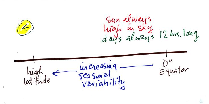
The sun is always pretty high in the sky (at noon) at the
equator; not
always overhead but always pretty high (66 degrees or more). That
coupled with the
fact that days are 12 hours long throughout the year means that there
is very little seasonal change in the amount of sunlight energy
arriving at the equator. Seasonal
variability increases as you move away from the equator toward higher
latitude.
We'll
finish with the summer solstice.
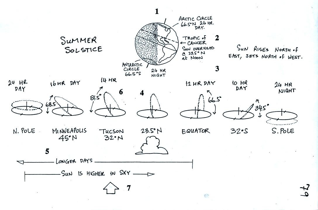
You'll find all the numbered points discussed on p. 80.
Here we'll just review the main points.
The North Pole is tilted toward the sun. There are 24
hours of daylight north of the Arctic Circle. There are 0 hours
of daylight (24 hours of night) south of the Antarctic Circle. At
the equator the days are always 12 hours long.
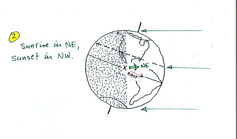
If you look east from position X in the picture you won't
see the sun
because you won't be looking back along the ray of light coming from
the sun. You must turn to the north. The sun rises in the
NE on the summer solstice and sets in the NW.
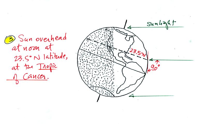
Rays of sunlight strike the globe perpendicularly at 23.5 N
latitude,
the Tropic of Cancer, at noon on the summer solstice.
Now the situation in Tucson on the summer solstice compared to the
equinoxes.
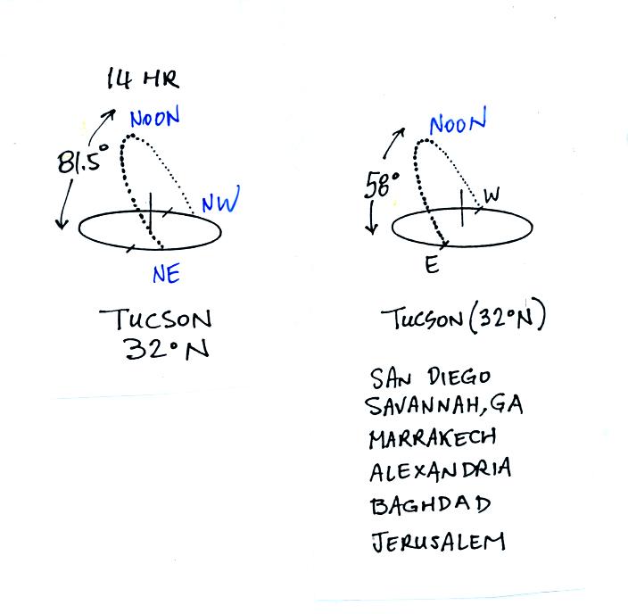
On June 21 the sun rises in the NE and sets in the NW. The sun is
81.5 degrees above the southern horizon at noon, almost overhead.
The days are 14 hours long. There is a lot more sunlight energy
arriving at the ground in summer than on the spring and fall equinoxes.
On the winter solstice we found that the two factors controlling the
amount of sunlight energy arriving at the ground worked together.
As you moved toward higher latitude there was less and less energy
reaching the ground because the days became shorter and the sun was
lower in the sky.
On the summer solstice the two factors don't work together. If
you move from Tucson to Minneapolis, the days become longer but the sun
is lower in the sky. This is shown schematically in the next
figure.
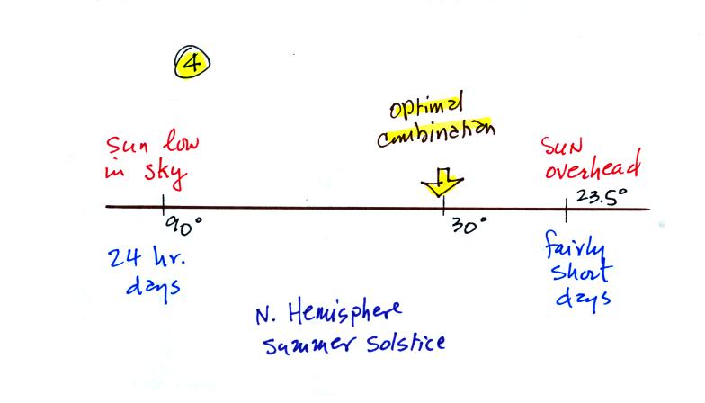
At high latitude the days are long but the sun is low in the sky.
At low latitude (23.5 degrees) the sun is overhead but the days are
shorter (just a little over 12 hours long). At some point in
between these
two extremes there must be an optimal combination of sun angle and
number of daylight hours, a combination that will result in the maximum
amount of sunlight energy arriving at the ground. This "optimum"
location is near 30 degrees latitude. The hottest
locations on earth are found near 30 degrees latitude.
Click here to review this
material on sun path diagrams and the seasons.